BEACH AND COASTAL DUNE DYNAMICS IMPACT ASSESSMENT THE PROPOSED MARINE TELECOMMUNICATIONS CABLE AT YZERFONTEIN, WEST COAST, WESTERN CAPE PROVINCE ...
←
→
Page content transcription
If your browser does not render page correctly, please read the page content below
BEACH AND COASTAL DUNE
                                                   DYNAMICS IMPACT
                                                      ASSESSMENT

                                                THE PROPOSED MARINE
                                                TELECOMMUNICATIONS
                                               CABLE AT YZERFONTEIN,
                                              WEST COAST, WESTERN CAPE
                                               PROVINCE, SOUTH AFRICA

                                              S C Bundy BSc MSc (Pr.Sci. Nat.)
                                              Sustainable Development Projects cc

                                              Compilled for: Acer (Africa) Environmental
                                              Consultants

Yzerfontein Ecomorphological Report: 2AFRICA/West Cable
                                             January    System
                                                      2021      January 2021
                                                            (rev04)

                                              Ref: acer/yzerfontein/00/21
                                                                                    Page 1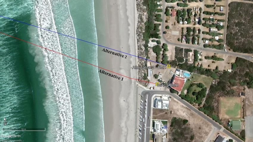
BEACH AND COASTAL DUNE DYNAMICS IMPACT ASSESSMENT

  PROPOSED MARINE TELECOMMUNICATIONS CABLE SYSTEM
      AT YZERFONTEIN, WESTERN CAPE, SOUTH AFRICA

                                       Contents

Executive Summary

1. Introduction………………………………………………………………………………                                               7

2. Project Description………………………………………………………………………                                           9

3. Method……………….………………………………………………………….……….                                                 10

4. Regional Perspective of Site….…………………………………….………………….                                    12

5. Site Evaluations…………….……………………………………………………………                                            16

6. Analysis of impacts……………………………………………………………………...                                         22

7. Conclusion and management recommendations………………………………………                                 26

 Compilation Date                                      January 2021
 Client                                                Acer (Africa) Environmental Consultants
 Compiled by                                           S C Bundy MSc (Pr Sci Nat)
 Company                                               SDP Ecological and Environmental Services
 Contact details                                       P O Box 1016, Ballito, 4420
 Telephone                                             032-9460685
 E mail                                                simon@ecocoast.co.za
 Reviewed by                                           N de Wet BSc Hons.
 Front page image                                      Beach and dune structure at Yzerfontein

Yzerfontein Ecomorphological Report: 2AFRICA/West Cable System January 2021              Page 2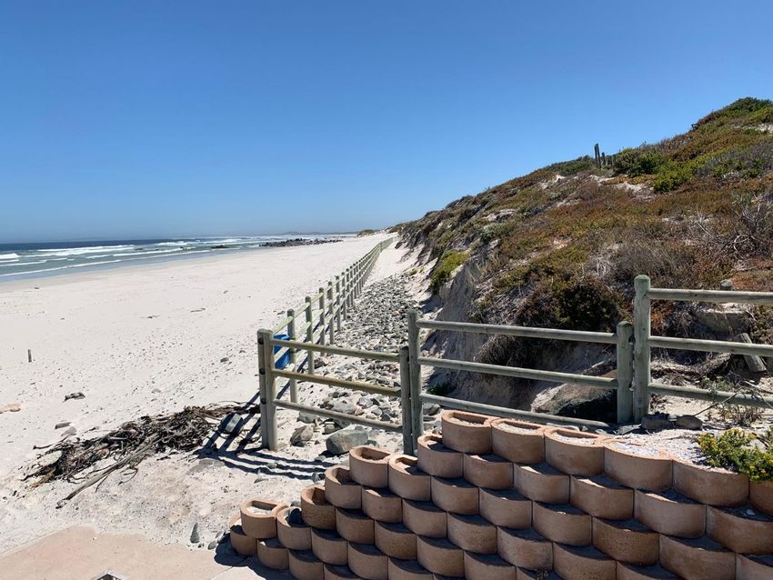
List of Figures

Figure 1                 Regional map                                                             7
Figure 2                 Cable route                                                              9
Figure 3                 Sample points                                                            12
Figure 4                 Wind rose map                                                            13
Figure 5                 Vegetation map                                                           14
Figure 6                 Screening report and CBA map                                             15
Figure 7                 Aerial photograph with relevant features                                 17
Figure 8                 Image of sea wall                                                        18
Figure 9                 Image of landing site at access to beach                                 18
Figure 10                Image of rip rap on dune                                                 19
Figure 11                Comparative aerial imagery from 2010 and 2015                            20
Figure 12                Image of frontal dune scarp                                              22

List of Tables

Table 1                  Impact assessment table                                                  24

Glossary of Terms and Abbreviations

Associes                 Groupings of species, particularly plants commonly found to occur together.
Dissipative              A dissipative beach is a wide beach with a low profile associated with high energy
                         surf zones.
Dune heel                The leeward extreme of a dune
Dune toe                 The seaward extreme of a dune
Eco-morphological        The physical and ecological result of plant and morphological drivers,
Hs                       Significant wave height
Psammo-                  Of dunes
Slack                    A valley or depression with the dune cordon

Yzerfontein Ecomorphological Report: 2AFRICA/West Cable System January 2021                            Page 3
DECLARATION BY THE SPECIALIST

I, Simon C. Bundy, declare that --

    •   I act as the independent specialist in this application;
    •   I do not have and will not have any vested interest (either business, financial, personal or other)
        in the undertaking of the proposed activity, other than remuneration for work performed in
        terms of the EIA Regulations, 2014;
    •   I will perform the work relating to the application in an objective manner, even if this results in
        views and findings that are not favourable to the applicant;
    •   there are no circumstances that may compromise my objectivity in performing such work;
    •   I have expertise in conducting the specialist report relevant to this application, including
        knowledge of the Waste Act and NEMA, regulations and any guidelines that have relevance to
        the proposed activity;
    •   I will comply with the Waste Act and NEMA, regulations and all other applicable legislation;
    •   I have no, and will not engage in, conflicting interests in the undertaking of the activity;
    •   I undertake to disclose to the applicant and the competent authority all material information in
        my possession that reasonably has or may have the potential of influencing - any decision to be
        taken with respect to the application by the competent authority; and - the objectivity of any
        report, plan or document to be prepared by myself for submission to the competent authority;
    •   all the particulars furnished by me in this form are true and correct; and
    •   I am aware that a person is guilty of an offence in terms of Regulation 48 (1) of the EIA
        Regulations, 2014, if that person provides incorrect or misleading information. A person who
        is convicted of an offence in terms of sub regulation 48(1) (a)-(e) is liable to the penalties as
        contemplated in section 49B(1) of the National Environmental Management Act, 1998 (Act
        107 of 1998).

SDP Ecological and Environmental Services

20 April 2021

Yzerfontein Ecomorphological Report: 2AFRICA/West Cable System January 2021                        Page 4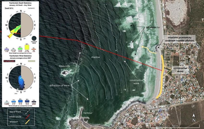
PARTICULARS OF AUTHORS/ECOLOGISTS

NAME Simon Colin Bundy. BSc. MSc Dip Proj Man
DATE OF BIRTH 7 September 1966                             PLACE OF BIRTH: Glasgow, Scotland.
MEMBERSHIP OF PROFESSIONAL BODIES: South African Council of Natural Scientific
Professionals No. 400093/06 – Professional Ecologist; Southern African Association of Aquatic
Scientists
KEY COMPETENCIES AND EXPERIENCE
Simon Bundy has been involved in environmental and development projects and programmes since
1991 at provincial, national and international level, with employment in the municipal, NGO and
private sectors, providing a broad overview and understanding of the function of these sectors. From
a technical specialist perspective, Bundy focusses on coastal and xeric ecological systems. He is
competent in a large number of ecological and analytical methods including multivariate analysis and
canonical analysis. Bundy is competent in wetland delineation and has formulated ecological coastal
set back methodologies for EKZN Wildlife and Department of Environmental Affairs. Bundy acts as
botanical and environmental specialist for Eskom. Based in South Africa, he has engaged in projects
in the Seychelles, Mozambique, Mauritius and Tanzania as well as Rwanda, Lesotho and Zambia.
Within South Africa , Bundy has been involved in a number of large scale mega power projects as
well as the development of residential estates, infrastructure and linear developments in all provinces.
In such projects Bundy has provided both technical support, as well as the undertaking of
rehabilitation programmes.

SELECTED RELEVANT PROJECT EXPERIENCE
Ecological investigations for numerous renewable energy projects, including “Kalbult”, “Dreunberg”,
“jUWI”, “Kenhardt Pv1 - 6”, “Solar Capital 2 and 3” and “Lindes”.
Ecological investigations Tongaat and Illovo Desalination Plants : CSIR –(2013 - 2016)
Ecological investigations and Rehabilitation Planning : Sodwana Bay :iSimanagaliso Wetland Park
Authority – (2014 - 2018)
Ecological evaluation and monitoring: Plastic pellet (nurdles) clean-up MSC Susanna Marine
Pollution Event : West of England Insurance, United Kingdom (2018 - 2020)

PUBLICATIONS
Over a dozen scientific publications, numerous popular articles and contributions to books and
documentaries in local and international journals

__________________________________________________________________________________

NAME Natalie de Wet BSc (Hons)
PROFESSION BSc Biodiversity and Ecology (Hons), Stellenbosch University
DATE OF BIRTH 20 March 1997

KEY COMPETENCIES AND EXPERIENCE
Natalie de Wet is an intern at SDP Ecological and Environmental Services. Her honours thesis
assessed the population genetics of the Critically Endangered Riverine Rabbit Bunolagus
Monticularis. Further course work included research projects on Proteaceae, Sugarbird Promerops
cafer, rocky intertidal communities as well as global change. Natalie has also interned at EnviroPro
where she job-shadowed Environmental Assessment Practitioners and Environmental Control
Officers.

Yzerfontein Ecomorphological Report: 2AFRICA/West Cable System January 2021                      Page 5
EXECUTIVE SUMMARY

The proposed landing of a marine telecommunications cable at Yzerfontein, is the subject of a basic
assessment evaluation in terms of the National Environmental Management Act (107 of 1998). This report
has been compiled to evaluate the bio physical impacts that the laying of such a cable would have on the
various inshore coastal processes at Yzerfontein, as well as to provide recommendations on environmental
management measures to be employed during and following establishment of the cable.

The proposed cable landing site traverses with a portion of a crenulate bay that lies to the north of
Yzerfonteinpunt on “Main Beach”. There are two minor deviations to the cable route at the landing site,
one of which follows an existing concrete pathway to a beach man hole (Alternative 1), and the other
traverses the dune cordon some 45m to the north of the walkway (Alternative 2).

Main Beach and adjacent portions of shoreline are subject to intermittent erosion, partly due to the focus
of incoming waves at a point central to the crenulate bay formation. Intrusion and stabilization of the sand
sharing system of the coast by urban infrastructure has also served to exacerbate such erosion.            The
response to erosion has been to establish a sea wall and other forms of defense, which effectively
dysfunctionalizes the beach – dune interface. These actions, in synchrony with ongoing climate change and
related factors has seen ongoing erosion along the shore where the cable is proposed for landing. The relic
frontal dune, immediately north of the cable landing point is presently an overly steep dune, with
intermittent undercutting by higher tidal inundation.

Given the above, Alternative 1 is the most prudent approach as it does not require excavation of the dune
cordon, as such this route would have low to very low coastal eco-morphological impacts and ramifications.
Sound management during the laying of the cable will see little impact on natural systems at the landing
point. Where disturbance does arise, it is clear that the affected natural areas are of little ecological value,
while measures to remediate any untoward disturbance can be easily implemented. Irrespective of the route
selected, management recommendations in respect of the establishment of the proposed cable routes are:

    1.   The cable should be buried within the beach to a depth >1m below the deflated beach state. While
         this state may be difficult to determine, the presence of a “shelly layer”, or evident differentiation
         in sediment grain diameter is a good indicator of suitable depth of burial within the beach profile.

    2.   If Alternative 2 is selected, the disturbed area of the vegetated dune should be raked back to an
         angle of repose ~ 27°, stabilised using a geofabric and suitably planted with appropriate vegetation.

Yzerfontein Ecomorphological Report: 2AFRICA/West Cable System January 2021                             Page 6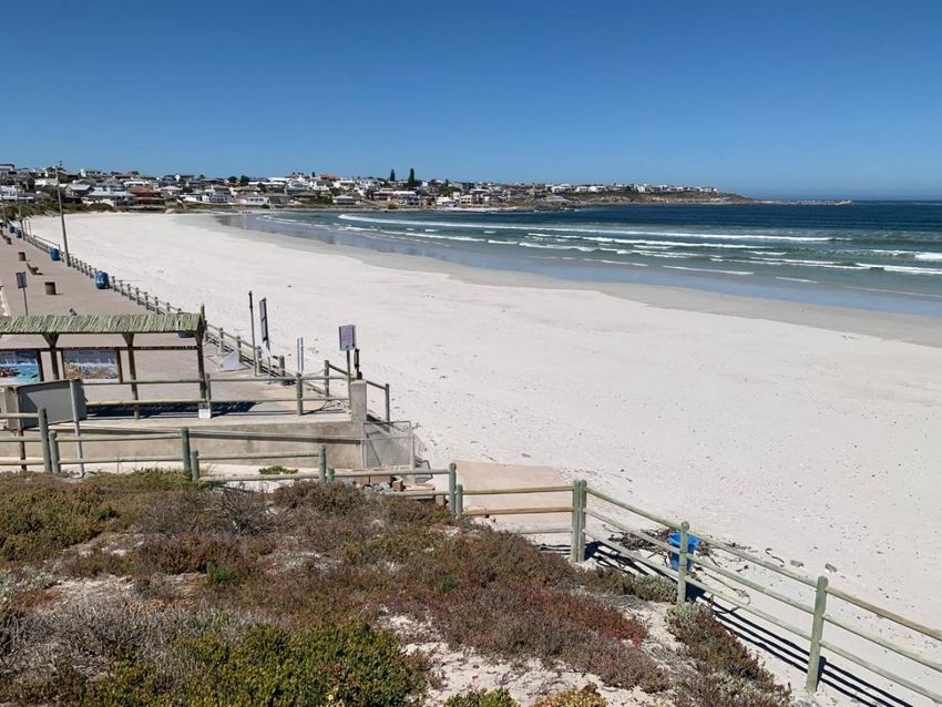
1. INTRODUCTION

Acer (Africa) Environmental Consultants have commenced with an environmental impact assessment
process (through a basic assessment application), to review and obtain authorisation from the National
Department of Environmental Affairs, for the installation of a marine telecommunications cable. The
cable is part of the 2AFRICA/West Cable System linking Africa with Europe and other centres through
submarine cables and thereby improving internet traffic through increased speed and data capacity.
This offshore cable is to be landed at Yzerfontein Main Beach on the West Coast located within the
Swartland Metropolitan Municipal area (Figure 1). Yzerfontein main beach is positioned at 33˚20’
23.11" S / 18° 9'38.51"E and can be accessed from the meeting point of Beach Road and Outer Road.

This report serves to provide a bio-physical overview of the beach and dune cordon within and adjacent
to the proposed landing points and the two alternative cable route alignments proposed for the site. The
investigation has been undertaken utilising various, selected parameters and identifies bio physical
factors associated with the area that may be considered drivers that determine the status and ecological
function of the beach and dune cordon. In addition, the investigation considers the ecological impacts
that may arise within the dune system from the establishment of the cable, the most appropriate routing
for the cable, as well as mitigation and management measures that may be employed during and post
the installation phase.

Yzerfontein Ecomorphological Report: 2AFRICA/West Cable System January 2021                     Page 7
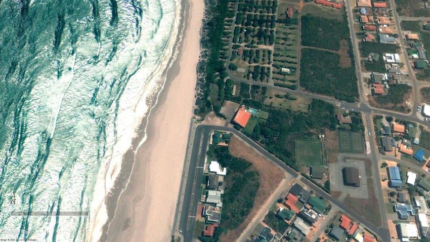
Figure 1. Regional map image of the subject site.

Yzerfontein Ecomorphological Report: 2AFRICA/West Cable System January 2021   Page 8
2. PROJECT DESCRIPTION

Telecommunications company, MTN plan to establish a submarine cable that will land at a point just
north of Yzerfonteinpunt, within the West Coast region.          The cable will effectively improve
international internet traffic via submarine cable to Europe and thereafter other global centres. Two
minor deviations to the route of the cable have been proposed, one of which traverses the sub-tidal,
inter-tidal and beach environment (Alternative 1; Figure 2), while the other traverses similar coastal
zones, but also crosses the dune environment (Alternative 2; Figure 2) and is positioned approximately
45m north of the route. Notably, Alternative 1 would be landed at an anchor block on the beach after
which it would link with an existing duct that is buried under the dune, north of the pedestrian pathway
(Figure 2). Ultimately, the cable will connect with an existing BMH or alternatively another BMH will
be established. The cable will then be routed underground from this point, landwards.

 Figure 2. Image of site of cable landing at Yzerfontein, showing two minor variations or alternative
                                                routes.

To install the cable, plant machinery and excavators will be utilised to establish a trench of
approximately 1- 2m below the prevailing natural ground level. Given the nature of dune and beach
sediments, excavations may be relatively wide, in order to accommodate trenching operations to this

Yzerfontein Ecomorphological Report: 2AFRICA/West Cable System January 2021                     Page 9
depth. The anchor block will form the anchor point for the cable. Excavated material is to be reinstated
over the cable and the necessary “rehabilitation” methods are to be employed.

2.1 Seasonality and limitations

The assessment was undertaken during January 2021, which is representative of a summer period and
generally inflated beach environment. The seasonality is given due consideration in the interpretation
of data. No data or observations for other seasons were available for comparison. Where such data
was required for assessment models, assumptions were made, based on accepted trends and predicable
seasonal changes. This study did not consider antecedent weather conditions and was conducted
during COVID1-19 beach restrictions. `

2.2. Applicable legislation

The National Environmental Management Act (Act no. 107 of 1998)

This Act serves to control the disturbance of land and its utilisation within certain habitats. Legislation
applicable to the proposed activity include Section 19 of Listing Notice 1, which states –
“The infilling or depositing of any material of more than 5 cubic metres into, or the dredging,
excavation, removal or moving of soil, sand, shells, shell grit, pebbles or rock of more than 5 cubic
metres from-
(i) a watercourse;
(ii) the seashore; or
(iii) the littoral active zone, an estuary or a distance of 100 metres inland of the high-water
mark of the sea or an estuary, whichever distance is the greater”

Integrated Coastal Management Amendment Act (36 of 2014)

ICMA presents several principles that relate to sound coastal management practices.               Principles
applicable to the proposed activity include Chapter 7, Section 58, which stipulates the duty of care and
remediation of environmental damage which includes the duty to avoid negative effects on the receiving
environment. As such, this Act applies to any activity that has an adverse effect on the coastal
environment.

     3. METHOD

In the compilation of this eco-morphological report a desktop review of literature and pertinent
information relating to the site was undertaken. Specific consideration was given to aerial imagery of
the shoreline and dune cordon. Desktop investigations included the following:

Yzerfontein Ecomorphological Report: 2AFRICA/West Cable System January 2021                        Page 10
• Review of recent and historical aerial imagery dating from 2000 to 2016.
• Identification and delineation of various plant community associes associated with the frontal
dunes.
• Dominant coastal processes were evaluated using available wave and wind data.
In addition, field reconnaissance was undertaken on 20 January 2021 whereby:
• Specific features within the supra-tidal environment were identified and logged using a Garmin
Montana GPS. It should be noted that access to the beach was restricted at this time, however
pertinent information was collated around the cable landing point.
• Dominant species were identified and recorded at the point of landing and such information
was used in an integrated manner to confirm the influence of coastal processes on the beach
and back of beach environment.
• General observations at each point were made in respect of the gradient of the dune face and
the nature and structure of the vegetation at the beach – dune interface.
• Limited sample data was collected on account of the nature of the site and restrictions relating
to access to the beach. However, data collected from site, allowed for the interpretation of the
coastal processes at the subject site.
Yzerfontein Ecomorphological Report: 2AFRICA/West Cable System January 2021 Page 11Figure 3. Image showing features identified and evaluated at the cable landing point.
4. REGIONAL PERSPECTIVE OF THE SUPRA-TIDAL ENVIRONMENT
Coastal processes in the nearshore and supra-tidal environment are driven by a number of complex bio-
physical processes (Elko 2016). Therefore, changes in wind, wave regimen, climate state, beach
morphology and additional factors influence the eco-morphology of coastal and in particular, dune
systems (Hesp 2012).
The wave climate along the Atlantic coastline of the Western Cape has been described by Roussouw
(1989), as a high energy regime, with the most proximal wave rider buoy in the region, recording a H s
(max) (wave height) of 10.8m with the most frequently occurring wave height being 3m (Joubert and
van Niekerk 2013). Such parameters indicate a coastline subject to significant marine inundation,
accounting for the dissipative beach environments common within the region.
Using wind statistics for Yzerfontein, it is evident that the Yzerfontein coastline is primarily affected
by southerly winds, however these do not necessarily align with the dominant south swell in the region
(Figure 4). This suggests that the area is dominated by a south easterly ground swell, with evident wind
swell playing a secondary role in wave set up. While sediment transport along the coastline of the West
Coast often reflects the movement of significant volumes of sand, the presence of rocky promontories,
inshore rocky shelves and other features serve to alter sediment transport and give rise to regions of
general sediment deprivation. As such, while sediment budgets along the shoreline of the West Coast
may generally reflect an inflated state, some areas may be subject to sediment deficit, particularly where
coastal processes have been subject to interruption by anthropogenic activities such as harbour
construction.
Yzerfontein Ecomorphological Report: 2AFRICA/West Cable System January 2021 Page 12Figure 4. Wind rose for the Yzerfontein region. See also Figure 7. A significant background factor affecting the Western Cape coastline is that of climate change giving rise to increasing storminess, coupled with sea level rise. According to Koeppen Geiger, the Western Cape region is classified as warm temperate: summer dry: summer hot (Csa) region with expectations of increasing aridity, reduced winter rainfall periods, and more severe storm events (www.koeppen- geiger.vu-wien.ac.at). In association with the abovementioned expectations, is the impact of sea level rise, which according to recorded data varies between 0.42 and 1.87 mm/year (Blake et al 2011). The National Oceanographic and Atmospheric Administration (NOAA) identifies a sea level rise rate of 1.94mm/year (https://coast.noaa.gov/digitalcoast/tools/slr), a slightly higher rate of increase than that reported by South African authors. Given the above, inundation along low lying areas of the West Coast is anticipated by authorities. This situation may also give rise to increasing erosion of soft coastlines, in particular dune forms, as well as beach erosion. In turn, saline intrusion into sub-surface, Yzerfontein Ecomorphological Report: 2AFRICA/West Cable System January 2021 Page 13
freshwater systems is likely to have a more latent but significant impact on the state and structure of
coastal dunes.

From an ecological perspective, habitat complexity and species diversity plays a significant role in
determining the state of beach and dune forms (Hesp 2012). Using SANBI data (Mucina and Rutherford
2006), the coastline of the subject area comprises of Cape Seashore vegetation, Langebaan Dune
Strandveld and Saldanha Flat Strandveld (Figure 5). From a habitat conservation perspective, Cape
Seashore vegetation is considered “least threatened”, Langebaan Dune Strandveld is considered
“vulnerable”, and Saldanha Flat Strandveld is considered “endangered”. These habitat types are
severely threatened by urban sprawl, agriculture and the invasion of alien plant species (SANBI 2021).

Figure 5. Map indicating subject site and the vegetation types recorded in the region (SANBI 2006).

Given the above, the Department of Environment, Forestry and Fisheries have identified the subject
area and the greater region around Yzerfontein as being of “very high sensitivity” from a terrestrial
biodiversity perspective (Figure 6, top). Figure 6 also suggests that while some portions of the coastline
may be of low sensitivity, primarily due to urban settlement, the dune cordon and supratidal
environment along the Yzerfontein coastline, remains of very high ecological sensitivity.

Yzerfontein Ecomorphological Report: 2AFRICA/West Cable System January 2021                      Page 14
In addition, the Provincial Conservation Authority considers the Yzerfontein landing point to be of
critical importance from a conservation perspective, as it falls within an Ecological Support Areas
(Figure 6, bottom).
Figure 6. Top) Screening Report Map for the project site showing predicted terrestrial species
sensitivity (Department of Environment, Forestry and Fisheries 2021). Bottom) The extent of Critical
Biodiversity Areas in the vicinity of Yzerfontein cable.
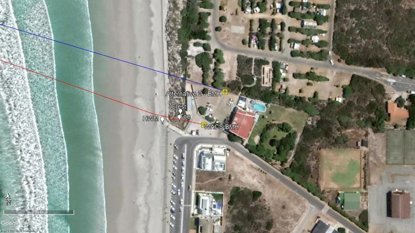
Yzerfontein Ecomorphological Report: 2AFRICA/West Cable System January 2021 Page 155. SITE SPECIFIC REVIEW OF THE SITE The cable landing site is proposed to be at Yzerfontein Main Beach. Main Beach is a wide embayment bound to the south by Yzerfonteinpunt (Figure 7). This deep crenulate bay sweeps northwards, backed by a rocky cliff, devoid of beach in the south, but as one progresses northwards, a steep dune and beach arises. The bay is interspersed with occasional rocky shelves and outcrops that play a significant role in sediment transport dynamics. Inshore circulation patterns and sediment transport processes within the crenulate bay at Yzerfontein are complex and variable (Figure 7). Yzerfonteinpunt, and associated rocky islands and promontories, serve to interrupt sediment transport in the immediate vicinity, as sediment influx through the littoral drift from the south, is captured and diverted offshore by these features. The shoreline and dune cordon at the subject site comprises of a narrow, but dissipative beach, which is backed by a mix of very steep dunes and at some points, rocky cliffs, as well as seawalls and related sea defence structures. Breaker height, wave period and grain size are fundamental drivers of beach state (Short 1981) and it is evident that both the prevailing natural features, in particular the Yzerfonteinpunt and Meeurots (an offshore island feature) are drivers of the state of the shoreline at the proposed point of the cable landing. These features give rise to a sheltered inshore environment under most conditions, which has been further reinforced to establish a small harbour facility. A wave shadow is evident within the bay, where diffracted waves entering the bay undergo destructive interference, that focusses on the opposite shore, just to the north of the cable landing site. However, constructive wave interference is evident and this phenomenon serves to focus incoming wave energy onto the shoreline in and around the cable landing point. This focus sets up an inshore rip current which sees sediment being moved along the beach and offshore at a rocky promontory located just to the north of main access and proposed landing point. As a result, the shoreline around the landing point is subject to erosion. Such erosion has been met by the establishment of a sea wall or sea defence rip rap (Figure 8). Such structures have served to abate erosion, at select points, however they have exacerbated erosion at other points that are not subject to protection (Cooper and Pilkey 2012) and it can be anticipated that further protection measures may be required along the beach to protect infrastructure. Once landed, there are two proposed routes for the 2AFRICA (West) cable across the supratidal environment, these being designated “Alternative 1” and “Alternative 2”. “Alternative 1” is proposed to align with an existing cable landing point. In this instance, the cable would be landed at a beach anchor block, where it would join with an existing duct that runs underneath the dune cordon before reaching the BMH (Figure 9). Yzerfontein Ecomorphological Report: 2AFRICA/West Cable System January 2021 Page 16
Figure 7. Aerial photograph showing features and coastal dynamics at site of cable landing, Yzerfontein.

Yzerfontein Ecomorphological Report: 2AFRICA/West Cable System January 2021                                         Page 17
Figure 8. Seawall to the south of the concrete pathway at “Alternative 1”.
Figure 9. Image across site of “Alternative 1” showing access to the beach. The cable will run
underneath the dune shown in the foreground.
Yzerfontein Ecomorphological Report: 2AFRICA/West Cable System January 2021
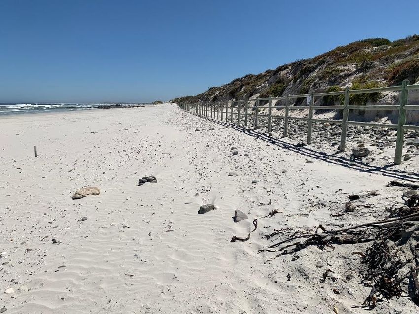
Page 18Further north of the walkway, the seawall and hard panned environment gives way to a natural dune
cordon. This natural dune cordon presents the site for the proposed cable landing route, referred to as
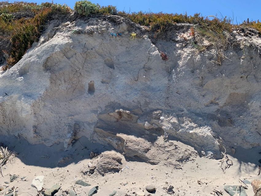
“Alternative 2”. This dune cordon is presently undergoing regression and collapse to form a steep dune
scarp (Figure 10). This failure has been recognised and attempts have been made to abate such erosion,
by establishing an informal rip rap at the base of the dune. The success of such measures is, however,
doubtful. It is also evident that much of the dune cordon at this point has been rendered effectively
dysfunctional through the establishment of urban infrastructure, including parking bays, roadways, and
ablution facilities. As such, it is predicted that “Alternative 2” will have little ecological impacts,
however it will require stringent rehabilitation to ensure the dune cordon is returned to its original state
once excavation for the cable has been performed.
Figure 10. Image showing rip rap on dune toe to the north of cable landing point, where “Alternative
2” is proposed.
Figure 11 below, shows comparative aerial imagery of the landing site in 2015 and 2020. What is
significant in this image is the inflated state of the beach in 2009, particularly to the south of the image,
comparative to the state in 2015 (as indicated by red arrows). This image supports the contention that
the beach is subject to significant periods of inflation and deflation, which evidently has an influence
on the adjacent dune cordon, as shown by the increased encroachment of sands into the dune cordon in
Yzerfontein Ecomorphological Report: 2AFRICA/West Cable System January 2021 Page 192010 (Figure 11). It can therefore be further deduced that beach inflation will be an important factor in
determining the depth of excavation within the back beach and inter-tidal environment.
Figure 11. Comparative aerial imagery of the landing site from 2009 and 2015, highlighting beach
profile and cross shore variation.
Yzerfontein Ecomorphological Report: 2AFRICA/West Cable System January 2021 Page 20From the information above, it can be suggested that:
• Erosion is a significant factor along the portion of coastline proposed for the landing of the
2AFRICA (West) cable.
• The beach profile is extremely variable, with a deflated beach state seeing marine incursion to
the toe of the frontal dune, under high seas.
• Much of the supra-tidal environment and dune cordon have effectively been rendered
dysfunctional by the sea defence systems established along the dune frontage, as well as other
urban infrastructure. However, in terms of the route options, it would be best to avoid
excavating the dune cordon for the landing of the cable, therefore “Alternative 1”, from an
ecological perspective, is more appropriate.
5.1 Ecological aspects
The frontal dune cordon, where not significantly altered by urban development presents typical
Langebaan Dune Strandveld. This veld type is deemed “vulnerable” from a conservation perspective.
The dominant and typical species encountered along the dune include Carpobrotus acinaciformis,
Ehrharta villosa, and Pelargonium fulgidum (Figure 12). At the point of the proposed cable landing,
the dune has been cleared and subject to excavation, effectively placing much of this portion of the dune
in an early seral state, dominated by Carpobrotus spp and Chrysanthemoides incana.
Yzerfontein Ecomorphological Report: 2AFRICA/West Cable System January 2021 Page 21Figure 12. Image of frontal dune scarp with typical vegetation including C. acinaciformis and E.
villosa.
Given the urban context of the site, alteration of the prevailing supra-tidal geomorphology and high
level of disturbance at the proposed site of the cable landing, it is evident that such impacts will continue
to maintain this habitat in an early seral state, while continuing marine driven erosion is likely to further
affect the frontal dune in its entirety. It follows that the implications of further disturbance at the site
would have minimal ecological ramifications from an ecological and conservation perspective.
6. ANALYSIS OF IMPACTS
There are two landing point that have been proposed at Yzerfontein. “Alternative 1” avoids the
excavation of the dune system, therefore reducing the impact on the surrounding environment. Whereas
“Alternative 2” requires excavation to traverse the dune cordon, which will have higher ecological
impacts and will require rehabilitation once the cable has been laid. Therefore, it is evident that the most
prudent approach for the landing of the cable, from the perspective of reduced environmental impact,
would be to follow “Alternative 1”.
Yzerfontein Ecomorphological Report: 2AFRICA/West Cable System January 2021 Page 22A number of minor permutations on routing of the sub-surface cable within the urban context of the
beachfront have been proposed, however these are of little ecological significance. In reviewing the
two proposed landing sites, it can be concluded that:
• The landing site for “Alternative 2” is subject to ongoing erosion and disturbance arising from
natural processes influencing coastal dynamics at this point.
• The abovementioned natural processes have been affected and altered by urban development
and sea defence measures, which in turn have further altered the state of the shoreline and coast
at this point.
• Eco-morphological processes have been disrupted in and around the point of both the cable
landing routes. Although elements of the prevailing habitat form, namely Langebaan Dune
Strandveld, persist, the habitat at this point remains in an early seral state.
From the above, it follows that the impacts associated with “Alternative 1” will have lower coastal eco-
morphological consequences than “Alternative 2”.
Table 1 below summarises the nature and form of impacts for “Alternative 1” and “Alternative 2” that
may arise on the three eco-morphological drivers of coastal systems, namely wind and wave, sediment
transport dynamics and the prevailing biotic or vegetated dune form. These impacts are evaluated to
identify their significance and the status of the impact.
From Table 1, it is clear that irrespective of the route selected, any negative impacts that arise in
response to the establishment of the cable, will be of short duration, evident during the laying of the
cable. Establishment of the cable at a suitable depth, will minimise any likelihood of such impacts
arising over an extended duration.
Yzerfontein Ecomorphological Report: 2AFRICA/West Cable System January 2021 Page 23Table 1. Review of ecological impacts arising from utilisation of the cable alignment route at Yzerfontein.
Cable
Spatial extent
Duration
Probability
Significance
Status
Confidence
2AFICA (West) Description & Mitigation
Yzerfontein Measures
IMPACT OF ALTERNATIVE 1
Alteration of Cable will align approximately shore perpendicular and lie at
drivers of coastal Very point >1m subsurface, effectively having no impact on localized
Local Short term Low Very Low High wind and wave regime. Some minor disruption of inter-tidal
process, (e.g. Wind Low
and supra-tidal wave regime may arise at point during
and wave) construction phase.
Interruption of Some minor perturbation expected during construction, with
sediment transport Local Short term Low Low Low High excavation of beach and intertidal zone. Following cable
establishment, sediment transport regime should rapidly reach
regime state of equilibrium.
Alteration of
Very Avoidance of vegetated, natural dune cordon is evident. Where
habitat/eco- Local Short term Low Low High disturbed, horticultural interventions to stabilize dune may be
Low
morphology practiced.
IMPACT OF ALTERNATIVE 2
Alteration of Cable will align approximately shore perpendicular and lie at
drivers of coastal Very point >1m subsurface, effectively having no impact on localized
Local Short term Low Very Low High wind and wave regime. Some minor disruption of inter-tidal
process, (e.g. Wind Low
and supra-tidal wave regime may arise at point during
and wave) construction phase.
Yzerfontein Ecomorphological Report: 2AFRICA/West Cable System January 2021 Page 24Interruption of Some minor perturbation expected during construction, with
sediment transport Local Short term Low Low Low High excavation of beach and intertidal zone. Following cable
establishment, sediment transport regime should rapidly reach
regime state of equilibrium.
Alteration of
Medium The dune and associated vegetation will be highly disturbed
habitat/eco- Local Medium Medium Medium High during the construction phase. Where disturbed, horticultural
term
morphology interventions to stabilize dune may be practiced.
Spatial Extent: Denotes the affected area, - site, local, regional or national
Duration: The period of time over which the impact will be noted. This may be “long term (greater than the duration of project), moderate or medium term (occurs during the lifetime of the
project) or “short term” (less than the lifetime of the project and primarily during the implementation stage of the project).
Probability: The likelihood of the impact occurring as a result of the project being undertaken. Such probability may be “high”, “moderate” or “low”.
Significance: The nature of the impact in respect to the status quo (i.e. alteration of status quo). Such levels of severity may be “high”, “moderate” or “low”.
Status: This refers to the overall impact determined from the above parameters.
Confidence: An indication of the level of surety that the impacts or the parameters identified, will occur.
Yzerfontein Ecomorphological Report: 2AFRICA/West Cable System January 2021 Page 257. CONCLUSION
The point of the proposed cable landing at Yzerfontein has been shown to be an eroding portion of
coastline that has been subject to various anthropogenic impacts, many of which are designed to
redress the evident erosion. As such the site can be considered to be a highly altered system. It is also
clear that erosion and further disturbance of the system may be exacerbated under a changing climate
and maritime regime, with a vacillating beach environment and further erosion of the frontal dune
anticipated.
Of the two proposed alternative alignments of the sub-surface cable at Yzerfontein, it is evident that
“Alternative 1” is the better approach. “Alternative 2” would require the trenching of portions of the
back beach and dune cordon, in order to allow for the cable to connect with land based infrastructure.
“Alternative 1”, on the other hand, meets with a beach anchor block and joins existing ducts that are
buried under the dune system. Therefore, this approach will have little further impact on the dune cordon
and the associated environment. Notably, the dune cordon where “Alternative 2” is proposed is
currently undergoing rehabilitation. Therefore, if this route is selected, management should ensure
minimal impacts occur on this coastal dune cordon. Therefore, the most prudent point of landing from
an eco-morphological perspective is “Alternative 1”.
Irrespective of the route selected, management interventions should be implemented to minimise
anticipated impacts. These can be summarised as:
1. The cable should be buried within the beach to a depth >1m below the deflated beach state.
While this state may be difficult to determine, the presence of a “shelly layer”, or evident
differentiation in sediment grain diameter is a good indicator of suitable depth within the beach
profile.
2. Where disturbance of the vegetated dune arises, the affected area should be raked back to an
angle of repose ~ 27°, stabilised using a geofabric and suitably planted with appropriate
vegetation.
3. The dune system should be fenced off using shade cloth to prevent any personnel traversing
the dune cordon unnecessarily during the construction phase of the project. The concrete
walkway north of the cable landing should be exclusively used for beach access.
Yzerfontein Ecomorphological Report: 2AFRICA/West Cable System January 2021
Page 26References (cited and uncited) ACER (Africa) Environmental Consultants. 2021. Background Information Document (Appendix 1). Cooper, A., Pilkey, O.H. (Eds.) (2012). Pitfalls of Shoreline Stabilization Selected Case Studies. Springer ISBN 978-94-007-4123-2. Elko, N., Brodie, K., Stockdon, H., Nordstrom, K., Houser, C., McKenna, K., Moore, L., Rosati, J., Ruggiero, P., Thuman, R., Walker, I. (2016). Dune management challenges on developed coasts. Shore & Beach, 84(1). Joubert J.R., van Niekerk, J.L. (2013). South African wave energy resource data: A case study. Mucina, L.M., Rutherford, M. (2006). The vegetation of South Africa, Lesotho and Swaziland. Strelitzia. Rossouw, J. (1989). Design waves for the South African coastline. PhD dissertation, Stellenbosch University. SANBI. (2021). Kirstenbosch Conservatory: The Coastal Fynbos Bed [online] Available at: https://www.sanbi.org/gardens/kirstenboch/seasons/botanical-society-conservatory/kirstenbosch- conservatory-the-coastal-fynbos-bed/ [Accessed 20 January 2021]. Tsoar, H., Levin, N., Porat, N., Maia, L.P., Herrmann, H.J., Tatumi, S., Claudino-Sales, V. (2009). The effect of climate change on the mobility and stability of coastal sand dunes in Ceara State, NE Brazil. Quaternary Research, 71(2): 217-226. Umvoto Africa. (2011). Sea Level Rise and Flood Risk Assessment for a Select Disaster Prone Area Along the Western Cape Coast. Phase 3 Report: West Coast District Municipality Sea Level Rise and Flood Hazard Risk Assessment. Provincial Government of the Western Cape Department of Environmental Affairs and Development Planning: Strategic Environmental Management (First Draft March 2011). Wright, L.D., Short, A.D. (1984). Morphodynamic variability of surf zones and beaches: A synthesis. Marine Geology, 56(4):93-118. Yzerfontein Ecomorphological Report: 2AFRICA/West Cable System January 2021 Page 27
Appendix A: A figure showing the 2 Africa (West) proposed route for the system cable approach.

Yzerfontein Ecomorphological Report: 2AFRICA/West Cable System January 2021              Page 28
You can also read