Screening Report for Appropriate Assessment of mixed-use development, Clongriffin, Dublin 13 - for Gerard Gannon Properties Pádraic Fogarty MSc, MIEMA
←
→
Page content transcription
If your browser does not render page correctly, please read the page content below
1

 Screening Report for Appropriate
    Assessment of mixed-use
development, Clongriffin, Dublin 13

  prepared by OPENFIELD Ecological Services
        for Gerard Gannon Properties

        Pádraic Fogarty MSc, MIEMA

                August 2019

                www.openfield.ie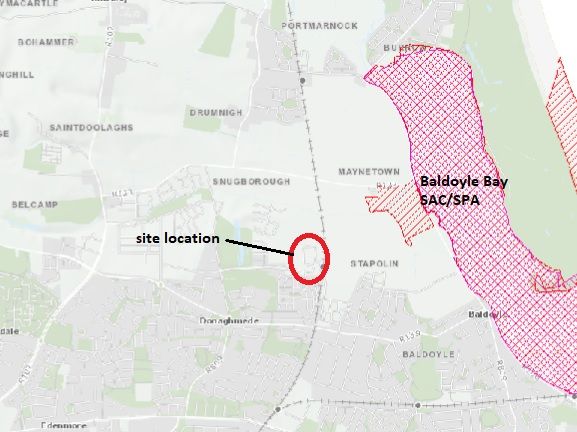
2

1.0    INTRODUCTION

1.1    About OPENFIELD Ecological Services
OPENFIELD Ecological Services is headed by Pádraic Fogarty who has worked for
over 20 years in the environmental field and in 2007 was awarded an MSc from Sligo
Institute of Technology for research into Ecological Impact Assessment (EcIA) in
Ireland. Pádraic has a primary degree in Analytical Science from DCU, and diplomas
in Field Ecology (UCC), Environment and Geography (Open University) and
Environmental Protection (IT Sligo). Since its inception in 2007 OPENFIELD has
carried out numerous EcIAs for Environmental Impact Assessment (EIA), Appropriate
Assessment under the EU Habitats Directive, as well as individual planning
applications. Pádraic is a full member of the Institute of Environmental Management.

1.2    Protection of biodiversity
Biodiversity is a contraction of the words ‘biological diversity’ and describes the
enormous variability in species, habitats and genes that exist on Earth. It is an
integral component of our heritage while also providing food, building materials, fuel
and clothing, maintaining clean air, water, soil fertility and pollinating crops. A study
by the Department of Environment, Heritage and Local Government placed the
economic value of biodiversity to Ireland at €2.6 billion annually (Bullock et al., 2008)
for these ‘ecosystem services’.

All life depends on biodiversity and its current global decline is a major challenge
facing humanity. In 1992, at the Rio Earth Summit, this challenge was recognised by
the United Nations through the Convention on Biological Diversity which has since
been ratified by 193 countries, including Ireland. Its goal to significantly slow down
the rate of biodiversity loss on Earth has been echoed by the European Union, which
set a target date of 2010 for halting the decline. This target was not met but in 2010
in Nagoya, Japan, governments from around the world set about redoubling their
efforts and issued a strategy for 2020 called ‘Living in Harmony with Nature’. In 2011
the Irish Government incorporated the goals set out in this strategy, along with its
commitments to the conservation of biodiversity under national and EU law, in the
second national biodiversity action plan (Dept. of Arts, Heritage and the Gaeltacht,
2011). A third plan was published in 2017.

In Europe, the main policy instruments for conserving biodiversity have been the
Birds Directive of 1979 and the Habitats Directive of 1992, which are transposed into
Irish law through the European Union (Natural Habitats) Regulations SI94/1997 (as
amended by SI233/1998 & SI378/2005). This legislation requires member states to
designate areas of their territory that are important for certain listed habitats and
species other than birds in the case of the Habitats Directive, and species or
significant gatherings of birds in the case of the Birds Directive. These areas are
known as Special Areas of Conservation (SAC) and Special Protection Areas (SPA)
respectively. Together SACs and SPAs form the Natura 2000 network of protected
sites. Unlike traditional nature reserves or national parks, Natura 2000 areas are not
‘fenced-off’ from human activity and are frequently in private ownership. It is the
responsibility of the competent national authority to ensure that ‘favourable
conservation status’ exists for their SACs and SPAs including that Article 6(3) of the
Habitats Directive is met. Article 6(3) requires that an ‘appropriate assessment’ (AA)
be carried out for those areas where projects, plans or proposals are likely to have an
3

effect. In some cases this is obvious from the start, for instance where a road is to
pass through a designated area. However, where this is not the case, a preliminary
screening must first be carried out to determine whether or not the full AA is required.

1.3    Purpose of this Report
This document provides for a screening of a mixed-use development in Clongriffin,
Dublin 13, and its potential effects in relation to Natura 2000 sites (SACs and SPAs).
The project is described thus, as per the planning application:

The lands subject to this application form part of a wider masterplan development
proposal for Clongriffin which provides for a total of 1,950 residential units and
c.22,727.5sq.m. of commercial development. The masterplan lands are divided into
three separate planning applications, in accordance with the legislative provisions of
the SHD process, such that two of which are SHD applications whilst the third
application is being lodged to Dublin City Council.

The proposed 1,950 residential units and c.22,727.5 sq.m. are provided across 15
no. Blocks (Blocks 3, 4, 5, 6, 8, 11, 13, 14, 15, 17, 25, 26, 27, 28 & 29) which range
in height and with a mix of 715 no. 1 bed units, 49 no. studios, 1,073 no. 2 bed
units and 113 no. three bed units. Of the 1,950 units proposed, 1,130 units are
proposed as Build to Rent units with 820 units proposed as Build To Sell/
Social/Private Tenure units. The overall 3 no. applications also provide for
22,727.5 sq.m. of commercial development including c. 30 no. retail units, 10 floors
of offices, 1 no. community room, 1 no. men’s shed, 3 no. creche facilities, 1 no. 8
screen cinema, 1 no. commercial gym, 7 no. cafes/ restaurants, in addition to the
4,335.1 sq.m. of residential support amenities/facilities (e.g. residents meeting
rooms, resident’s gym, resident’s cinema room, etc.) proposed across all blocks. The
development also includes car parking, bicycle parking, landscaping including
playgrounds, public open space parks, utilisation of existing infrastructure and all
associated works necessary to facilitate the development.

This document will assess whether effects to the Natura 2000 network are likely
occur as a result of the operation phase of this project (there will be no construction
phase). It will determine whether these effects are likely to be significant, and if so,
will recommend appropriate mitigation measures.

1.4    Methodology
The assessment was carried out in accordance with the following methodologies and
guidelines:

1.     ‘Assessment of plans and projects significantly affecting Natura 2000 sites.
       Methodological guidance on the provisions of Article 6(3) and (4) of the
       Habitats Directive 92/43/EEC’ (Oxford Brookes, 2001). Annex 2 of this
       document sets out an assessment template that is used in this report.
2.     ‘Appropriate Assessment of Plans and Projects in Ireland. Guidance for
       Planning Authorities’ (DOEHLG 2009).

Note: Reference from this point forth to the ‘site’ indicates the development
site and not the SAC or SPA.
4 In accordance with the above-mentioned guidance notes, the following steps are followed: Step 1: Analysis of the SAC/SPA This involves assessing the current status of the SAC/SPA and underlying trends affecting it. This is done through a combination of literature review, site survey, and consultation with relevant stakeholders where necessary. Step 2: Analysis of the proposed development Identifying aspects of the project that may affect the SAC/SPA Step 3: Analysis of other plans and projects Identifying aspects of other plans or projects that may act ‘in combination’ with the proposed development to affect the integrity of the SAC/SPA Step 4: Determination of significance Determination whether any of these effects, either alone or in combination with other plans and projects, will be significant. The AA process is an iterative one where the report actively identifies potential effects, the project is then modified to avoid or mitigate these effects, and then the new project design is re-assessed until such point as no significant effects are predicted to occur. It is important to note that any AA, or screening for AA, is carried out by the competent authority (in this case Fingal Council) and this screening report has been prepared in order to aid that decision.
5

2.0    Step 1 – Analysis of the Natura 2000 network

2.1    Site location and extent
The development site is located to the west of the Dublin to Belfast railway line and
to the north of Dublin City. This location is shown in figure 1 which also shows its
position in relation to nearby water courses.

Figure 1 – Location of development site at Clongriffin (red circle) showing proximity to
Natura 2000 areas. SACs are shown in tan while SPAs are shown in lime green (from
www.npws.ie )

There is no prescribed radius around a site for determining what Natura 2000 sites
should be studied. This is determined by the zone of influence of the project although
a preliminary radius of 2km is usually examined (IEA, 1995). Figure 1 shows this
area and as can be seen there are number of Natura 2000 sites within this
approximate radius. Water courses drain to Baldoyle Bay, which is a SPA and SAC.
In addition to these European designations Baldoyle Bay is also recognised as a
wetland of international importance under the RAMSAR Convention (site 25/10/88). It
is also a proposed Natural Heritage Area, a designation under national legislation.

EPA mapping shows that the Mayne River flows a short distance to the north of the
site boundary and this discharges into Baldoyle Bay. The site is within an area which
has seen extensive residential development in recent years and this can be seen in
recent aerial photography as shown in figure 2.

A site visit was carried out for this study on October 11th 2018. Habitats are described
here in accordance with standard classifications (Fossitt, 2000). All areas are
composed of a combination of spoil and bare ground – ED2 and recolonising bare
6

ground – ED3. This is characteristic of highly disturbed ground and is not of high
ecological value or in any way associated with habitats or species for which SACs or
SPAs are normally designated.

There are no alien invasive plant species as listed on Schedule 3 of SI No. 477 of
2011. There are no water courses or drainage ditches which could provide direct
pathway to the Mayne River.

Figure 2 – Indicative location and extent of the Clongriffin site. The boundary of the
Baldoyle Bay SAC and SPA is approximately 1.2km to the east at its nearest point.
7
2.2 Natura 2000 Sites
The SAC and SPA in Baldoyle are connected to the project via the Mayne River.
Wastewater from the development will pass to the municipal sewer for Dublin City at
Ringsend, and the point of discharge from this facility is also within a number of
SACs and SPAs in Dublin Bay.
2.2.1 Baldoyle Bay SAC (code: 0199)
This SAC is the estuary of the Sluice and the Mayne Rivers that is largely enclosed
by a sand spit that stretches from Portmarnock to Howth. At low tide it has large
areas of exposed mud and sediment that support rich invertebrate communities.
There are a number of habitats here that are listed in the EU’s Habitats Directive
Annex I while there are two plants recorded from the Bay that are protected under
the Flora Protection Order: Borrer’s Saltmarsh-grass Puccinellia fasciculata and
Meadow Barley Hordeum secalinum.
The reasons why the bay falls under the SAC designation are set out in the qualifying
interests. They are either habitat types listed in Annex I or species listed in Annex II
of the Habitats Directive. This information is provided by the National Parks and
Wildlife Service (NPWS) and is shown in table 1 below. In this case the SAC is
designated only for protected habitat types.
Table 1 – Qualifying interests for the Baldoyle Bay SAC (from NPWS)
Code Habitats
1140 Mudflats and sandflats not covered by seawater at low tide
1310 Salicornia and other annuals colonizing mud and sand
1330 Atlantic salt meadows
1410 Mediterranean salt meadows
Tidal mudflats (1140). This is an intertidal habitat characterised by fine silt and
sediment. Most of the area in Ireland is of favourable status however water
quality and fishing activity, including aquaculture, are negatively affecting some
areas.
Salicornia mudflats (1310): This is a pioneer saltmarsh community and so is
associated with intertidal areas. It is dependant upon a supply of fresh, bare mud
and can be promoted by damage to other salt marsh habitats. It is chiefly
threatened by the advance of the alien invasive Cordgrass Spartina anglica.
Erosion can be destructive but in many cases this is a natural process.
Atlantic and Mediterranean salt meadows (1330 & 1410): these are intertidal
habitats that differ somewhat in their vegetation composition. They are dynamic
habitats that depend upon processes of erosion, sedimentation and colonisation
by a typical suite of salt-tolerant organisms. The main pressures are invasion by
the non-native Spartina anglica and overgrazing by cattle and sheep.
2.2.2 Baldoyle Bay SPA (site codes: 4016)
Estuarine habitats are some of the most productive in the world and the nutrients that
are deposited here fuel primary and secondary production (levels in the food chain)
that in turn provide food for internationally significant numbers of wintering birds
(Little, 2000). It had a mean of 5,780 birds between the winters of 2006/07 and
2010/11 (Crowe et al., 2012). Specifically it has a number of species which are8
‘features of interest’ of the SPA, along with ‘wetlands and waterbirds’. Table 2 details
these.
Table 2 – Features of Interest for the Baldoyle Bay SPA (from NPWS)
Species Status1
Branta bernicula hrota Light-bellied brent goose Amber
Charadrius hiaticula Ringed plover Green
Limosa lapponica Bar-tailed godwit Amber
Pluvialis apricaria Golden plover Red
Pluvialis squatarola Grey plover Amber
Tadorna tadorna Shelduck Amber
Wetlands & Waterbirds
Light-bellied Brent Goose. There has been a 67% increase in the distribution of
this goose which winters throughout the Irish coast. The light-bellied subspecies
found in Ireland breeds predominantly in the Canadian Arctic.
Ringed Plover. This bird is a common sight around the Irish coast where it is
resident. They breed on stony beaches but also, more recently, on cut-away bog
in the midlands.
Bar-tailed Godwit. These wetland wading birds do not breed in Ireland but are
found throughout the littoral zone during winter months. They prefer estuaries
where there are areas of soft mud and sediments on which to feed.
Golden Plover. In winter these birds are recorded across the midlands and
coastal regions. They breed only in suitable upland habitat in the north-west.
Wintering abundance in Ireland has changed little in recent years although it is
estimated that half of its breeding range has been lost in the last 40 years.
Grey Plover. These birds do not breed in Ireland but winter throughout coastal
estuaries and wetlands. Its population and distribution is considered to be stable.
Shelduck. The largest of our ducks, Shelduck both breed and winter around the
coasts with some isolate stations inland. Its population and range is considered
stable.
2.2.3 Natura areas in Dublin Bay
The South Dublin Bay and River Tolka Estuary SPA (site code: 4024); and the South
Dublin Bay SAC (0210) are considered to fall within the zone of influence as they are
within the hydrological catchment of the site.
Table 3 – Features of interest for the South Dublin Bay & River Tolka Estuary SPA (EU
code in square parenthesis)
South Dublin Bay and Tolka Estuary SPA
Light-bellied Brent Goose (Branta bernicla hrota) [A046]
Oystercatcher (Haematopus ostralegus) [A130]
Ringed Plover (Charadrius hiaticula) [A137]
Grey Plover (Pluvialis squatarola) [A140]
Knot (Calidris canutus) [A143]
Sanderling (Calidris alba) [A144]
Dunlin (Calidris alpina) [A149]
1
Birds of Conservation Concern in Ireland. Colhoun & Cummins, 20139
Bar-tailed Godwit (Limosa lapponica) [A157]
Redshank (Tringa totanus) [A162]
Black-headed Gull (Croicocephalus ridibundus) [A179]
Roseate Tern (Sterna dougallii) [A192]
Common Tern (Sterna hirundo) [A193]
Arctic Tern (Sterna paradisaea) [A194]
Wetlands & Waterbirds [A999]
The South Dublin Bay and Tolka Estuary SPA (side code: 4024) is largely
coincident with the South Dublin Bay SAC boundary with the exception of the Tolka
Estuary. These designations encompass all of the intertidal areas in Dublin Bay from
south of Bull Island to the pier in Dun Laoghaire. Wintering birds in particular are
attracted to these areas in great number as they shelter from harsh conditions further
north and avail of the available food supply within sands and soft sediments. Table 1
lists the features of interest for both of the SPAs.
Light-bellied Brent Goose. There has been a 67% increase in the distribution of
this goose which winters throughout the Irish coast. The light-bellied subspecies
found in Ireland breeds predominantly in the Canadian Arctic.
Sanderling. This small bird breeds in the high Arctic and winters in Ireland along
sandy beaches and sandbars. Its wintering distribution has increased by 21% in
the previous 30 years.
Dunlin. Although widespread and stable in number during the winter season, the
Irish breeding population has collapsed by nearly 70% in 40 years. Breeding is
now confined to just seven sites in the north and west as habitat in former nesting
areas has been degraded.
Knot. These small wading birds do not breed in Ireland but gather in coastal
wetlands in winter. Their numbers have increased dramatically since the mid-
1990s although the reasons for this are unclear.
Black-headed Gull. Widespread and abundant in winter these gulls are
nevertheless considered to be in decline. The reasons behind this are unclear but
may relate to the loss of safe nesting sites, drainage, food depletion and increase
predation.
Ringed Plover. This bird is a common sight around the Irish coast where it is
resident. They breed on stony beaches but also, more recently, on cut-away bog
in the midlands.
Oystercatcher. Predominantly coastal in habit Oystercatchers are resident birds
whose numbers continue to expand in Ireland.
Bar-tailed Godwit. These wetland wading birds do not breed in Ireland but are
found throughout the littoral zone during winter months. They prefer estuaries
where there are areas of soft mud and sediments on which to feed.
Grey Plover. These birds do not breed in Ireland but winter throughout coastal
estuaries and wetlands. Its population and distribution is considered to be stable.
Roseate Tern. This tern breeds at only a few stations along Ireland’s east coast.
Most of these are in decline although at Dublin their colony is increasing.
Common Tern. This summer visitor nests along the coast and on islands in the
largest lakes. Its breeding range has halved in Ireland since the 1968-1972
period.
Arctic Tern. These long-distance travellers predominantly breed in coastal areas
of Ireland. They have suffered from predation by invasive mink and are declining
in much of their range.10
Redshank. Once common breeders throughout the peatlands and wet
grasslands of the midlands Redshanks have undergone a 55% decline in
distribution in the past 40 years. Agricultural intensification, drainage of wetlands
and predation are the chief drivers of this change.
Bird counts from BirdWatch Ireland are taken from Dublin Bay as a whole and are not
specific to any particular portion of the Bay. Dublin Bay is recognised as an
internationally important site for water birds as it supports over 20,000 individuals.
Table 4 shows the most recent count data available2.
Table 4 – Annual count data for Dublin Bay from the Irish Wetland Birds Survey
(IWeBS)
Year 2010/11 2011/12 2012/13 2013/14 2014/15 Mean
Count 27,931 30,725 30,021 35,878 33,486 31,608
There were also internationally important populations of particular birds recorded in
Dublin Bay (i.e. over 1% of the world population): Light-bellied brent geese Branta
bernicula hrota; Black-tailed godwit Limosa limosa; Knot Calidris canutus and Bar-
tailed godwit L. lapponica.
The South Dublin Bay SAC (side code: 0210) is concentrated on the intertidal area
of Sandymount Strand. It has one qualifying interest which is mudflats and sandflats
not covered by seawater at low tide. Tidal mudflats (habitat code: 1140) is an
intertidal habitat characterised by fine silt and sediment. Most of the area in Ireland is
of favourable status however water quality and fishing activity, including aquaculture,
are negatively affecting some areas. At a national scale, it is assessed as of
‘intermediate’ status (NPWS, 2013).
The North Dublin Bay SAC (site code: 0206) is focussed on the sand spit on the
North Bull island. The qualifying interests for it are shown in table 5. The status of the
habitat is also given and this is an assessment of its range, area, structure and
function, and future prospects on a national level and not within the SAC itself.
Table 5 – Qualifying interests for the North Dublin Bay SAC
Habitat/Species Status3
Mudflats and sandflats not covered by seawater at low tide Intermediate
Salicornia and other annuals colonizing mud and sand Intermediate
Atlantic salt meadows Intermediate
Mediterranean salt meadows Intermediate
Annual vegetation of drift lines Intermediate
Embryonic shifting dunes Intermediate
Shifting dunes along the shoreline with Ammophila arenaria
Intermediate
(white dunes)
Fixed coastal dunes with herbaceous vegetation (grey dunes) Bad
Humid dune slacks Intermediate
2
https://f1.caspio.com/dp.asp?AppKey=f4db3000060acbd80db9403f857c
3NPWS. 2013. The Status of EU Protected Habitats and Species in Ireland. Habitat Assessments
Volume 2. Version 1.0. Unpublished Report, National Parks & Wildlife Services. Department of Arts,
Heritage and the Gaeltacht, Dublin, Ireland.11
Petalophyllum ralfsii Petalwort Good
Shifting dunes along the shoreline with Ammophila arenaria (white dunes)
(2120). These are the second stage in dune formation and depend upon the
stabilising effects of Marram Grass. The presence of the grass traps additional
sand, thus growing the dunes. They are threatened by erosion, climate change,
coastal flooding and built development.
Fixed coastal dunes with herbaceous vegetation (grey dunes) (2130). These
are more stable dune systems, typically located on the landward side of the
mobile dunes. They have a more or less permanent, and complete covering of
vegetation, the quality of which depends on local hydrology and grazing regimes.
They are the most endangered of the dune habitat types and are under pressure
from built developments such as golf courses and caravan parks, over-grazing,
under-grazing and invasive species.
Humid dune slacks (2190). These are wet, nutrient enriched (relatively)
depressions that are found been dune ridges. During winter months or wet
weather these can flood and water levels are maintained by a soil layer or
saltwater intrusion in the groundwater. There are found around the coast within
the larger dune systems.
Petalwort (1395). There are 30 extant populations of this small green liverwort,
predominantly along the Atlantic seaboard but also with one in Dublin. It grows
within sand dune systems and can attain high populations locally.
Whether any of these SACs or SPAs is likely to be affected must be measured
against their ‘conservation objectives’. Specific conservation objectives have been
set for all of these areas.
Specific conservation objectives have been set for mudflats in the South Dublin Bay
SAC (NPWS, 2013) and for all qualifying interests the North Dublin Bay SAC (NPWS,
2013). The objectives relate to habitat area, community extent, community structure
and community distribution within the qualifying interest. There is no objective in
relation to water quality.
For qualifying interests in the South Dublin Bay other than mudflats, generic
conservation objectives are available and are stated as:
To maintain or restore the favourable conservation condition of the Annexed
habitats for which the SAC has been selected.
In a generic sense ‘favourable conservation status’ of a habitat is achieved when:
• its natural range, and area it covers within that range, are stable or increasing, and
• the specific structure and functions which are necessary for its long‐term
maintenance exist and are likely to continue to exist for the foreseeable future, and
• the conservation status of its typical species is favourable.
While the ‘favourable conservation status’ of a species is achieved when:
• population dynamics data on the species concerned indicate that it is maintaining
itself on a long‐term basis as a viable component of its natural habitats, and
• the natural range of the species is neither being reduced nor is likely to be reduced
for the foreseeable future, and
• there is, and will probably continue to be, a sufficiently large habitat to maintain its
populations on a long‐term basis.12 For the South Dublin Bay & Tolka Estuary SPA and the North Bull Island SPA the conservations objectives for each bird species relates to maintaining a population trend that is stable or increasing and maintaining the current distribution in time and space (NPWS, 2015a & b). 2.3 Literature Review As can be seen from figures 1 and 2, the site is not located within or directly adjacent to any area designated for nature conservation. It is situated approximately 2.1km from the boundary of the Baldoyle Bay SAC and SPA. The site is situated within the catchment of the Mayne River, which flows approximately 280m to the north of the boundary. The River Mayne is a relatively short water course that rises to the east of Dublin airport and enters the Irish Sea at Baldoyle. The Environmental Protection Agency maintains one monitoring station, at the Wellfield Bridge, and here ecological conditions were most recently (2016) assessed as ‘poor’. Under the Water Framework Directive the overall status of the Mayne catchment has been assessed as of ‘poor’ status. This indicates point or diffuse pollution sources, or other ecological problems such as obstructions. The ecological quality of the transitional water body at Baldoyle Bay has been assessed as ‘eutrophic’, indicting ‘bad’ status. Dublin Bay is currently assessed as ‘good status’. 2.4 Consultation Because of the low ecological sensitivity of this site no third-party consultation was carried out. 2.5 Trends affecting the SAC/SPA There are no management plans for the designated areas in Baldoyle Bay however some work has been done to determine the site-specific trends or threats to their conservation status. Tables 6 & 7 shows the most recent bird count data from Baldoyle Bay and these show that while numbers fluctuate from one year to the next, positive or negative trends are not clear. These data are likely to mask variations between species present and as table 2 shows there are a number of species here that are of high and medium conservation concern (red and amber lists). However a link between water quality and bird numbers cannot be established. In fact, the discharge of nutrient effluent from artificial fertilisers and poorly treated sewage can promote primary production that in turn provides food for wintering and resident birds in bays and estuaries (Nairn & O’Halloran eds., 2012). Table 6 – Bird count data from the winters of 2005/06 – 2009/10 (Crowe et al., 2011; Boland & Crowe, 2006) 01/02 02/03 03/04 04/05 05/06 06/07 07/08 08/09 09/10 10/11 8,891 6,825 4,290 4,626 4,196 5,927 5,544 5,766 5,884 -
13

Table 7– Baldyole Bay bird count data (Irish Wetland Bird Survey)
 Year        2010/11     2011/12      2012/13      2013/14      2014/15     Mean
 Number      N/A         N/A          N/A          6,459        3,994       5,227

The status of features of interest in the Bladoyle Bay SPA has been assessed
(NPWS, 2012c). Of those species with unfavourable status in the SPA, Ringed
Plover and Bar-tailed Godwit have exhibited losses at Baldoyle Bay while the
national population remains stable or has increased. It is therefore reasonable to
assume that local factors are leading to declines. The NPWS list a number of factors
that may be contributing to this including human disturbance (walkers with or without
dogs) and nutrient enrichment (pollution). The latter effect is exhibited by algal mats,
typically Sea-lettuce Ulva sp. which covers the sediment surface at low tide. This is
good for those species which feed on Sea-lettuce but bad for those which cannot
reach their favoured prey under the mats.

Water quality in the catchment is monitored by the Environmental Protection Agency
(EPA) which maintains a regular assessment programme. At the monitoring point
along the Mayne, which enters Baldoyle Bay, site water quality has most recently
been determined to be ‘poor status’. Meanwhile the trophic status of Baldoyle Bay
has been assessed as ‘eutrophic’ (from www.epa.ie).

Pollution may be a factor in the poor status of Bar-tailed Godwit and Ringed Plover at
Baldoyle Bay due to reasons already described.

3.0     Step 2 – Analysis of the Project
This application is for the construction of a mixed-use development along with all
associated services as described under section 1.3.

The construction phase will see site preparation followed by a construction phase
using standard building materials.

There is currently no attenuation of surface water and rain falling on the site
percolates to the ground. The subject lands are served by an existing storm water
drainage system approved and constructed under the Clongriffin parent planning
Reg. Ref. 0132/02. The surface water sewers constructed under the parent planning
permission discharge to the attenuation pond at the northeast of the Clongriffin
scheme before discharging to the Mayne River at a controlled rate of 249 l/s, as
permitted under the parent planning permission.

Foul and surface drainage infrastructure will be entirely separate. Wastewater from
the proposed development will be sent to the wastewater treatment plant at
Ringsend in Dublin. Emissions from the plant are currently not in compliance with the
Urban Wastewater Treatment Directive. Irish Water, the authority in charge of the
wastewater treatment network, has prioritised the enhancement of the Ringsend
plant in its Proposed Capital Investment Programme 2014-2016. In February 2018
Irish Water announced proposals to upgrade the Ringsend plant and apply for
planning permission for a new plant in north County Dublin. This will see improved
treatment standards and will increase network capacity by 50%, with a target
completion date of 2023.
14

Figure 3 – Proposed development layout
15

4.0    Step 3 – Analysis of Other Plans and Projects
Individual impacts from one-off developments or plans may not in themselves be
significant. However, these may become significant when combined with similar,
multiple impacts elsewhere. These are sometimes known as cumulative impacts but
in AA terminology are referred to as ‘in combination’ effects.

In terms of the conservation objectives of the SACs and SPAs identified in section
2.2, maintaining the extent and condition of important habitats and species
populations is vital.

The catchment of the Mayne River has been substantially transformed in the past
15-20 years from farmland to built development. The area is currently a combination
of open park spaces, with significant built development including residential and
retail uses.

The cumulative effects of this type of urban growth can arise from replacing
permeable ground with hard surfaces. This can result in increased risk of flooding
and deterioration of water quality, primarily from the run-off of particulate matter and
hydrocarbon residues (Mason, 1996). To combat this effect the Greater Dublin
Strategic Drainage Study was published in 2005. This aims to ensure that new
developments integrate sustainable drainage systems (SUDS) to maintain natural, or
‘green field’ rates of surface water run-off while also improving water quality in rivers.
This development is fully complaint with these SUDS principles. As there will be no
change in the extent of hard surfacing, this development will result in a slight positive
impact to surface water.

The first River Basin Management Plan (RBMP) was published under the EU’s Water
Framework Directive in 2010. This set out to attain ‘good ecological status’ of all
water bodies by 2027 at the latest. It included a ‘programme of measures’ that was to
address point or diffuse pressures on water quality. The Mayne River is currently
assessed as ‘poor’ while Baldoyle Bay is ‘eutrophic’. Under the second RBMP 2018-
2021 the Mayne River is identified as one of 190 ‘priority areas for action’.

This project can be seen in combination with continued suburban style development
in Clongriffin (and indeed across the Dublin region). This is planned for under
relevant development plans, such as the Dublin City Development Plan 2016-2022.
The planning authority has carried out an AA and concluded that the implementation
of this plan would not result in significant effects to Natura 2000 areas.

The growth of population in the Dublin area is placing pressure on wastewater
treatment infrastructure and plans are underway to increase capacity at Ringsend as
well as development new treatment facilities in the north of the county, as detailed in
the Fingal County Development Plan. Current compliance issues are not believed to
be resulting in significant effects to Natura 2000 areas in Dublin Bay.
16

5.0     Step 4: Determination of Significance

5.1     Impact prediction
Under Article 6 of the Habitats Directive the term ‘significance’ is taken to mean an
effect on the SAC or SPA as measured against the relevant conservation objective.
Unlike Environmental Impact Assessment for instance, there are no degrees of
significance and where an effect is determined to be significant mitigation or
avoidance measures must be considered.

In order for an impact to occur there must be a pathway between the development
(the source) and the SAC or SPA (the receptor). Where a pathway does not exist
then an impact cannot occur.

The subject site is not located within, or directly adjacent to any SAC or SPA.
However a pathway for impacts exists via surface water to the Baldoyle Bay
SAC/SPA and wastewater to Natura 2000 areas in Dublin Bay.

The development will not result in direct impacts to habitats within any designated
area, either through habitat removal or disturbance.

Site specific conservation objectives have been set for the SAC and SPA in both
Baldoyle Bay and Dublin Bay. None of these objectives relates to water quality.
Pollution is in any case undesirable and this development should not infringe upon
efforts to enhance water quality under the Water Framework Directive.

Following on from steps 1 – 3 of this process a number of specific impacts are
considered:

5.1.1   Habitat loss

This development is will not result in the loss of semi-natural habitats connected to
Natura 2000 areas.

5.1.2   Habitat disturbance

No habitats will be disturbed within or directly connected to Natura 2000 areas.

Indirect disturbance via amenity pressures on coastal areas is unlikely to arise from
this project due to the nature of the works and their distance to Natura areas.

5.1.4   Pollution during normal operation

The use of accepted SUDS techniques in the design of the project has ensured that
negative effects to water quality cannot arise from surface water run-off. Even in the
absence of these measures, significant effects are not likely to arise as sediment is
not a pollutant in a coastal/intertidal context. Bays and estuaries rely on vast
quantities of sediment for the normal functioning.

There is a pathway from the site wastewater water flows to Dublin Bay via the
Ringsend wastewater treatment plant. While the issues at Ringsend wastewater
treatment plant are being dealt with in the medium term evidence suggests that some
nutrient enrichment is benefiting wintering birds for which SPAs have been
designated in Dublin Bay (Nairn & O’Hallaran eds, 2012). Additional loading to this
17

plant arising from the operation of this project are not considered to be significant
based on two points:

1.     There is no evidence that pollution through nutrient input is affecting the
conservation objectives of the South Dublin Bay and River Tolka Estuary SPA.
Indeed water quality in the bay is currently assessed as ‘good’.

2.      Accepting that pollution is undesirable, regardless of the conservation
objectives of the SPA, and would be contrary to the aims of the Water Framework
Directive, then the upgrading works at Ringsend wastewater treatment plant will
address future capacity demand.

5.1.5   Abstraction

The Liffey Lower WMU states that 100% of its catchment is affected by abstraction.
Freshwater for this development originates from the reservoirs along the River Liffey
in Co. Kildare, which are also located at Leixlip. There is no pathway between this
abstraction point and any Natura 2000 area. As such water that is abstracted for this
plant cannot impact upon Natura areas. This impact is therefore not significant.

5.1.6   Light and noise

The project will result in no additional noise or artificial lighting and given the urban
context of this development, this impact can be considered to be not significant.

6.0     Conclusion and Finding of No Significant Effects
This proposed development is not located within or directly adjacent to any SAC or
SPA but pathways do exist to a number of these areas. An assessment of the
aspects of this project has shown that significant negative effects are not likely to
occur to these areas either alone or in combination with other plans and projects.
18

7.0    REFERENCES
Bullock C., Kretch C. & Candon E. 2008. The Economic and Social Aspects of
Biodiversity. Stationary Office.

Colhoun K. & Cummins S. 2013. Birds of Conservation Concern in Ireland 2014 –
2019. Irish Birds. Volume 9 Number 4 pg523-541.

Council Directive 92/43/EEC of 21 May 1992 on the conservation of natural habitats
and of wild fauna and flora

Council Directive 97/11/EEC of 3rd March 1997 amending Directive 85/337/EEC on
the assessment of the effects of certain public and private projects on the
environment

Crowe O., Boland H. & Walsh A. 2012. Irish Wetland Bird Survey: results of
waterbird monitoring in Ireland in 2010/11. Irish Birds Volume 9 Number 3 pg397-
410.

Department of Arts, Heritage and the Gaeltacht. 2011. Actions for Biodiversity
2011 – 2016. Ireland’s National Biodiversity Plan.

Department of Environment, Heritage and Local Government. 2009. Appropriate
Assessment of Plans and Projects in Ireland. Guidance for Planning Authorities’

DG Environment. 2003. Interpretation Manual of European Union Habitats.
European Commission.

Fossitt J. 2000. A Guide to Habitats in Ireland. Heritage Council.

Institute of Environmental Assessment, 1995. Guidelines for Baseline Ecological

Little C. 2000. The Biology of Soft Shores and Estuaries. Oxford University Press.

Mason C.F. 1996. Biology of Freshwater Pollution. Longman

Nairn R. & O’Halloran J. Editors. 2012. Bird Habitats in Ireland. The Collins Press.

NPWS. 2000. Baldoyle Bay Special Area of Conservation: Site Synopsis.

NPWS. 2003. Baldoyle Bay Special Protection Area: Site Synopsis Report.

NPWS. 2012a. Conservation Objectives: Baldoyle Bay SAC 000199. Version 1.0.
National Parks and Wildlife Service, Department of Arts, Heritage and the Gaeltacht.

NPWS. 2012b. Baldoyle Bay SPA Conservation Objectives Supporting Document.
Version 1.

NPWS. 2013. Conservation Objectives: Baldoyle Bay SPA 004016. Version 1.
National Parks and Wildlife Service, Department of Arts, Heritage and the
Gaeltacht

Oxford Brookes University. 2001. Assessment of plans and projects significantly
affecting Natura 2000 sites. Methodological guidance on the provisions of Article 6(3)
19

and (4) of the Habitats Directive 92/43/EEC. European Commission, Environment
DG.

Tomankova, I. et al. 2013. Chlorophyll-a concentrations and macroinvertebrate
declines coincide with the collapse of overwintering diving duck populations in a large
eutrophic lake. Freshwater Biology doi:10.1111/fwb.12261.
You can also read