West QE2 - MAJOR AREA STRUCTURE PLAN - (West of Highway Queen Elizabeth II) - The City of Red Deer
←
→
Page content transcription
If your browser does not render page correctly, please read the page content below
West QE2
(West of Highway Queen Elizabeth II)

- MAJOR AREA STRUCTURE PLAN -
            Bylaw No. 3398-2007
         Amendment No. 3398/A-2009
         Amendment No. 3398/A-2019

             December 2007
          Amended February 2010
          Amended May 27, 2019
CITY OF RED DEER
                                                             WEST QE2
                                        MAJOR AREA STRUCTURE PLAN

Table of Contents

 1.0   INTRODUCTION ................................................................................................................................. 1
       1.1 AREA LOCATION..................................................................................................................................... 1
       1.2 ENABLING LEGISLATION ........................................................................................................................ 1
       1.3 BACKGROUND ....................................................................................................................................... 1
       1.4 PLANNING FRAMEWORK ....................................................................................................................... 3
           1.4.1 City of Red Deer Strategic Plan ................................................................................................... 3
           1.4.2 County – City Intermunicipal Development Plan ........................................................................ 3
           1.4.3 Municipal Development Plan ...................................................................................................... 3
           1.4.4 Area Structure Plans .................................................................................................................... 3
           1.4.5 Land Use Bylaw ........................................................................................................................... 3
           1.4.6 Additional Policies for Industrial Planning .................................................................................. 3
 2.0   PLAN VISION ..................................................................................................................................... 5
       2.1 PLAN GOAL ............................................................................................................................................ 5
       2.2 PLAN OBJECTIVES .................................................................................................................................. 5
 3.0   EXISTING SITE CHARACTERISTICS ....................................................................................................... 6
       3.1 TREE AND WETLAND NATURAL HABITAT AREAS .................................................................................. 6
       3.2 NATURAL RESOURCE EXTRACTION AND LANDFILLS ............................................................................. 7
           3.2.1 Natural Resource Extraction ....................................................................................................... 7
           3.2.2 Landfills........................................................................................................................................ 7
       3.3 EXISTING ZONING AND LAND USE ......................................................................................................... 9
 4.0   DEVELOPMENT CONCEPT ................................................................................................................ 10
       4.1 LAND USE ............................................................................................................................................. 10
           4.1.1 Industrial and Business Services................................................................................................ 10
           4.1.2 Vehicle, Recreational Vehicle, and Machinery Dealerships District ......................................... 10
           4.1.3 Green Infrastructure and Eco-Industrial Park ........................................................................... 13
           4.1.4 Commercial ............................................................................................................................... 13
       4.2 DEVELOPMENT STANDARDS ............................................................................................................... 14
           4.2.1 Major Entry Area Landscaping Requirements .......................................................................... 14
           4.2.2 Interface Treatment of Adjacent Lands .................................................................................... 15
       4.3 VEHICLE AND PEDESTRIAN CIRCULATION ........................................................................................... 15
           4.3.1 Trail System ............................................................................................................................... 15
           4.3.2 Transit ........................................................................................................................................ 15
           4.3.3 Roadways .................................................................................................................................. 15
       4.4 PUBLIC OPEN SPACE ............................................................................................................................ 19
       4.5 EMERGENCY SERVICES ........................................................................................................................ 21
       4.6 LAND USE STATISTICS .......................................................................................................................... 21
 5.0   MUNICIPAL UTILITY SERVICES .......................................................................................................... 23
       5.1 STORM WATER DRAINAGE .................................................................................................................. 23
       5.2 SANITARY SEWER ................................................................................................................................. 23
       5.3 WATER DISTRIBUTION ......................................................................................................................... 28
       5.4 POWER DISTRIBUTION ........................................................................................................................ 28
       5.5 NATURAL GAS ...................................................................................................................................... 28
 6.0   PLAN IMPLEMENTATION ................................................................................................................. 31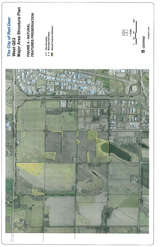
6.1 DEVELOPMENT PHASING .................................................................................................................... 31
     6.2 AREA STRUCTURE PLANS ..................................................................................................................... 31
     6.3 AMENDMENTS TO THIS PLAN ............................................................................................................. 31
          6.3.1 Future Planning ......................................................................................................................... 31
     6.4 BURNT LAKE AREA STRUCTURE PLAN ................................................................................................. 32
     6.5 PLAN REVIEW ....................................................................................................................................... 32
APPENDICIES .............................................................................................................................................. 33
     APPENDIX 1 – NATURAL FEATURES ............................................................................................................ 33

LIST OF FIGURES

Figure 1: Plan Area
Figure 2: Resource Extraction
Figure 3: Land Use Concept
Figure 4: Natural Features Preservation
Figure 5A: Catchment Delineation & Storm Water Servicing
Figure 5B: Overall Storm Water Concept
Figure 5C: Storm Main Servicing Concept
Figure 6: Sanitary Servicing Concept
Figure 7: Water Servicing Concept
Figure 8: Electrical Servicing Concept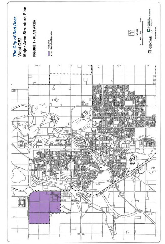
CITY OF RED DEER

WEST QE2
MAJOR AREA STRUCTURE PLAN

1.0 INTRODUCTION

1.1    AREA LOCATION

       The West QE2 area consists of 8 quarter sections, totalling approximately 503.7 ha (1,245 acres)
       of land. The area is located in the north west quadrant of Red Deer, situated west of Queen
       Elizabeth II Highway (formerly Provincial Highway No. 2) and south of Highway 11A. The area is
       shown in Figure 1 - Plan Area. In 2007, these lands were annexed by the City of Red Deer from
       Red Deer County as part of an annexation application seeking areas for new industrial growth for
       the city. The subject lands are presently held by several different owners. Primary access into
       the area is from Highway 11A.

1.2    ENABLING LEGISLATION

       This plan is intended as a major area structure plan for the lands within the West QE2 area. A
       major area structure plan (MASP) is a generalized plan, typically covering several quarter
       sections of land. Major area structure plans are prepared by The City of Red Deer to set broad
       planning direction for the specified area of land. The plans are broader in nature than an
       individual industrial or neighbourhood area structure plan as MASPs cover several
       neighbourhoods or several quarter sections of development. MASPs identify only major roads
       such as expressways and arterial roadways and general categories of land use such as
       commercial, industrial, residential, school sites, and major parks. More detailed planning dealing
       with matters such as local roads or specific land use districts is carried out at the neighbourhood
       or industrial area structure plan level.

       The West QE2 Major Area Structure Plan has been adopted by The City as a statutory plan in
       accordance with Section 633 of the Municipal Government Act.

1.3    BACKGROUND

       Prior to annexation in 2007, the lands in the plan area were within the jurisdiction of Red Deer
       County. At that time they were included within the Burnt Lake Area Structure Plan (adopted by
       Red Deer County Council in March 2000). The Burnt Lake Area Structure Plan provided for
       industrial land uses. However, in 2007 following annexation, the City of Red Deer adopted the
       West QE2 MASP. As a result of the approval of this plan by The City of Red Deer, the lands
       contained within it are no longer governed by Red Deer County’s Burnt Lake Area Structure Plan.

       In order to address evolving land use and transportation considerations, amendments to the
       West QE2 MASP were proposed in 2009. Amendments specific to evolving land use were
       proposed in 2019.

West QE2 Major Area Structure Plan                                                               1
May 2019
West QE2 Major Area Structure Plan   2
May 2019
1.4    PLANNING FRAMEWORK

       The West QE2 Major Area Structure Plan is one of a series of inter-related planning documents
       adopted by the City of Red Deer. These plans include:

       1.4.1   City of Red Deer Strategic Plan
               The City of Red Deer Strategic Plan is adopted to provide long term municipal direction in
               all aspects of city services. It serves as the basis for municipal programs and services.
               The 2009-2011 plan includes a vision, mission statement, and goals. The objectives of
               the plan and strategies for achieving the plan were brought forward to Council for
               approval in 2009.

       1.4.2   County – City Intermunicipal Development Plan
               Intermunicipal planning provides for any two or more neighbouring municipalities to jointly
               plan for growth and development such as future land uses, roads, and services. An
               Intermunicipal Development Plan (IDP) must establish a process for dispute resolution as
               well as for administration of the plan. In October 1999, the City and County councils
               adopted their first Intermunicipal Development Plan. The IDP was reviewed in 2007 and a
               new plan was adopted by both councils. The current IDP includes areas of land
               surrounding the city which have now been annexed into the city’s jurisdiction and which
               are now contained within the West QE2 MASP. This document complies with the IDP.

       1.4.3   Municipal Development Plan
               Under the Municipal Government Act, the City is required to adopt a Municipal
               Development Plan (MDP). The City adopted the current MDP in 2008. The Municipal
               Development Plan provides generalized land use policies for future land use, provision of
               servicing, and facilities such as roads as well as proposed phasing of development.

       1.4.4   Area Structure Plans
               The West QE2 is one of three Major Area Structure Plans adopted within the city; the
               others include the Northwest Major Area Structure Plan and the East Hill Major Area
               Structure Plan. These plans cover several quarter sections of land. Neighbourhood
               Area Structure plans (including industrial area structure plans) are adopted under each of
               these Major Area Structure Plans.

       1.4.5   Land Use Bylaw
               The Land Use Bylaw divides the city into districts and regulates the use of land and
               development. The Land Use Bylaw implements the policies and goals outlined in the
               Municipal Development Plan and any area structure plans.

       1.4.6   Additional Policies for Industrial Planning

               In addition to the Land Use Bylaw and statutory and strategic plans, The City of Red Deer
               has specific policies relating to industrial planning. These policies include Industrial
               Planning Guidelines & Standards. In addition, ecological profiles are prepared for all
               neighbourhoods or areas prior to development including areas intended for industrial
               development.

               The City of Red Deer Industrial Planning Guidelines & Standards provides guidelines and
               standards based on Smart Growth principles for the planning and design of industrial
               areas including land use, roadways, servicing, the natural environment and heritage, and
               safety. This document provides the requirements for industrial ASPs and the subdivision
               approval process.

West QE2 Major Area Structure Plan                                                               3
May 2019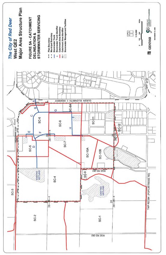
The West QE2 area is part of the Regional Ecological Profile - Proposed Industrial Lands
               and Associated Natural Areas (2005/2007). This report provides a detailed overview of
               natural environmental features within the plan area along with recommendations for their
               preservation. The document is designed to identify and recommend regional preservation
               priorities for natural habitat that may be impacted by development in the proposed area.
               The document offers strategies for the incorporation and use of natural habitat as a green
               resource or green infrastructure.

West QE2 Major Area Structure Plan                                                              4
May 2019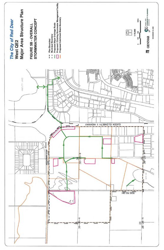
2.0 PLAN VISION

2.1    PLAN GOAL

       The goal of the West QE2 Major Area Structure Plan is to provide a framework for the orderly
       and efficient development of lands within the City of Red Deer west of the Queen Elizabeth II
       Highway. Lands are to be developed in a sustainable manner which fosters economic
       development, social wellbeing, and a high quality built and natural environment.

2.2    PLAN OBJECTIVES

       The following objectives support the goal:

          i)   To plan for the provision of an adequate supply of lots for industrial land uses and
               complimentary commercial land uses consistent with planning, environmental, and market
               requirements;
          ii) To facilitate the establishment of locations for highly desirable business and employment
               opportunities;
          iii) To provide a planning, infrastructure and service framework for the subdivision of
               industrial lots in a manner that promotes economic, social, and ecological sustainability;
          iv) To preserve and protect special natural features (natural capital) in the plan area;
          v) To acknowledge and respect the intent of the existing Red Deer County land use plans
               while planning for a sustainable future for the City of Red Deer and to acknowledge and
               respect existing development within the plan area.

       In pursuing these goal and objectives, the plan compiles with The City’s Industrial Area Planning
       Guidelines & Standards. Furthermore, the plan attempts to address environmentally sustainable
       principles and best management practices including ecological conservation, management of the
       city’s ecological footprint, the use of green infrastructure, and efforts to work towards regional
       conservation.

West QE2 Major Area Structure Plan                                                              5
May 2019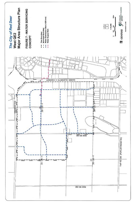
3.0 EXISTING SITE CHARACTERISTICS

3.1    TREE AND WETLAND NATURAL HABITAT AREAS

       The topography of the plan area consists of generally flat land, with a marked rise towards the
       west boundary of the plan area. Most of the undeveloped land in the plan area has been used
       primarily for agricultural purposes with limited vegetation and small tree stands remaining. Water
       courses, wetlands and a variety of natural areas, including treed areas or other vegetation growth
       and escarpment exist within the plan area.

       In preparing this plan The City’s Ecospace (Natural Habitat) Management Plan which is updated
       regularly to preserve and enhance Red Deer’s natural environment through careful community
       planning, as well as the more detailed Regional Ecological Profile – Proposed Industrial Lands &
       Associated Natural Areas (2005/2007) were consulted. Appendix 1, Natural Features, illustrates
       the location of the natural features in the area at the time that the regional eco-space profile was
       prepared. At the time of the regional ecological profile the identified tree stands were generally
       comprised of good quality vegetation. As well, at that time, seasonal streams following the
       natural contours of the land were also evident in the West QE2 area.

       In addition, two major wetlands are located in the plan area – one which straddles the northerly
       boundary and one which straddles the southerly boundary (Cameo Lake) of the plan area. The
       primary function of wetlands, as noted in the regional profile, is the provision of natural catchment
       and cleansing areas to conserve and protect ground water. The wetlands in this area may
       experience wetter or drier phases and short term changes or undulations in water levels. This is
       normal. Wetland wildlife and vegetation will affect and be affected by water level changes. Any
       development within these areas shall conform to the policies of Alberta Environment’s Wetland
       Restoration/Compensation Policy.

       The natural areas in the West QE2 MASP include lands which serve as drainage areas or natural
       features serving as wildlife corridors and significant reserves of biodiversity. These preservation
       focus areas are identified to flag their presence and significance and to develop strategies for
       their preservation. The preferred strategy is to preserve these focus areas intact as natural
       features. Alternately, where it is not possible to preserve them as natural areas, it is suggested
       that they be blended with constructed components for storm water drainage or within roadways.

       Focus preservation areas identified in Appendix 1 are the following:

       W1      -   this wetland is a permanent pond/lake. It is a probable wildlife movement/staging
                   area. It also contributes to flood and erosion control and the long-term maintenance of
                   the hydrological regime within and beyond its boundaries;
       W2      -   this wetland is a semi-permanent pond which contributes to flood and erosion control;
       W3      -   this wetland is a semi-permanent pond surrounded by shrubs and trees;
       T       -   small and large tree stands, and shelter belts that provide wildlife habitat and/or
                   corridors, some of which may be remnants of the original aspen parkland that have
                   been left intact as part of the evolving agricultural landscape.

       It is the general intent of this plan to attempt to preserve the tree stands, shelter belts and
       wetlands identified in the regional ecological profile for preservation focus to as great an extent
       as is possible based on the development concept and based on what is remaining as of the date
       of the adoption of this plan. This will be achieved by designating the selected areas (shown in
       Figure 3) as municipal reserve or environmental reserve.
West QE2 Major Area Structure Plan                                                                 6
May 2019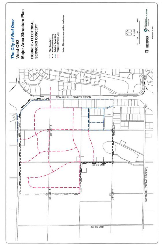
Based on the report Wetland Ecological Assessment (2005) prepared by Westhoff Engineering
       Resources Inc. all the wetlands in the plan area have wide riparian zones which are very
       sensitive and have high ecological value. Therefore a wide buffer free of construction should be
       left around the wetlands. The report indicated that there is also the opportunity to incorporate the
       wetlands into the storm water management plan.

3.2    NATURAL RESOURCE EXTRACTION AND LANDFILLS

       3.2.1   Natural Resource Extraction

               Subsurface activity/extraction of oil and gas is occurring in the West QE2 area. Figure 2
               identifies active and abandoned oil and gas wells and pipelines. The required setbacks
               from these wells and pipelines, as prescribed by the Energy Resources Conservation
               Board (ERCB) for Alberta, will be detailed in Phase 1 site assessments, which will be
               submitted as part of any subsequent industrial area structure plan (IASP).

               In the detailed planning and design for each development phase, the IASP will
               incorporate any required setbacks in any one of a number of ways: as part of a public
               utility lot, as part of municipal reserve (but not necessarily included as part of the required
               10% municipal reserve dedication), within road right of way, or as easements across
               industrial land, subject to approval by the City.

               The relatively large lot sizes in an industrial area means that some of the required pipeline
               and well setbacks could potentially be accommodated within utility easements. This
               category of utility easement remains within the private property; however, development on
               the easement is restricted.

               The City’s policy with regard to future oil and gas extraction facilities is outlined in the
               Municipal Development Plan.

       3.2.2   Landfills

               To the best of our knowledge there are no landfill sites within the plan area. A Phase 1
               Environmental Site Assessment for each development phase will provide additional
               information on landfill sites should any be discovered.

               As per the Province of Alberta Subdivision and Development Regulation, a 450-metre
               development setback is required from any active landfill site and a 300-metre
               development setback is required from any inactive or closed landfill site. This setback
               applies to subdivision or development for a school, hospital, food establishment or
               residential (including commercial accommodation) use. The City may apply to Alberta
               Environment to reclassify dry landfill sites, based on case by case requests supported
               with geotechnical evidence.

West QE2 Major Area Structure Plan                                                                   7
May 2019
West QE2 Major Area Structure Plan 8 May 2019
3.3    EXISTING ZONING AND LAND USE

       The plan area and adjacent lands are predominantly used for agriculture, agricultural business,
       light industry and residential (scattered farmsteads and first-parcel-out dwelling units). The West
       QE2 Major Area Structure Plan recognizes the existing designations and land uses on lands
       adjacent to the plan area within Red Deer County, and proposes compatible land uses. Where
       there is a potential incompatibility, such as between the proposed industrial land uses and the
       proposed golf course community on the N ½ of Section 26-38-28-4, the plan proposes buffering
       measures to mitigate potential adverse land use impacts.

       Prior to annexation, and therefore prior to the original adoption of this MASP, the lands within the
       plan area were designated under the Red Deer County Land Use Bylaw within the Ag
       (Agricultural), BSI (Business Service Industrial) and MI (Medium Industrial) Districts.

West QE2 Major Area Structure Plan                                                                9
May 2019
4.0 DEVELOPMENT CONCEPT
4.1 LAND USE
All future subdivision and development within the plan area shall conform to the land use concept
illustrated in Figure 3. The land use concept is based on current and anticipated industrial market
trends, the objectives of this plan, as well as relevant principles contained in the City’s Municipal
Development Plan, Industrial Area Planning Guidelines & Standards and The City of Red Deer
2004 Growth Study.
4.1.1 Industrial and Business Services
The majority of land within the plan area is designated for industrial use, which includes,
but is not limited to: oilfield activities, industrial support services, manufacturing,
processing, warehousing, and distribution. Properties within this use category are
designated into the I1 Industrial (Business Services) District or the I2 Industrial (Heavy
Industrial) District depending on the probability of nuisance factors as described in the
Land Use Bylaw. Within the West QE2 area all I2 Districts shall maintain a setback
distance of:
400 metres from Provincial Highways 11A and the Queen Elizabeth II.
100 metres from any arterial roadway
100 metres from the plan boundary, where the plan abuts an area other than that
proposed or developed for industrial uses
Parcels within the I2 District shall not abut any eco-industrial parks, however they may be
located adjacent to one another where they are separated by a roadway, berm or other
land use.
4.1.2 Vehicle, Recreational Vehicle, and Machinery Dealerships District
Parcels located along Highway QEII have higher than the usual visibility given the volume
of traffic passing by on the highway. While the West QE2 area is intended as an
industrial area, it is recognized that not all industrial uses require this amount of exposure.
On the other hand, it has been suggested that many commercial land uses (specifically
vehicle, recreational vehicle, and machinery dealerships) do require moderate to highly
visible locations. In considering the most appropriate use of the parcels along Highway
QEII, many needs and issues had to be considered as these related to both industrial and
vehicle sales related land uses.
Review of traffic considerations, development needs, current development levels and
pressures, and the mitigation and prevention of conflict between land uses were all key
components in looking at future land use in this location. In brief, planning and traffic
engineering research indicated that parcels along Highway QEII are highly visible allowing
the type of marketing opportunities required by vehicle dealers. It was also
acknowledged that some of the properties are already operating as dealerships. Under I1
zoning, these businesses would be non-conforming. Further, studies indicated that
vehicle and machinery sales and service uses in the area can be supported through
roadway enhancements and should not cause excessive conflict with other land uses in
the area if restricted to specific locations.
West QE2 Major Area Structure Plan 10
May 2019Therefore, specific parcels adjacent to the Highway QEII, as identified on Figure 3, have
been designated for a specialized land use district which will build upon the key locational
attributes of these parcels. This specialized district allows for the continued operation of
the land uses which are existing at present (where development has already occurred),
but also allows for the development of automobile dealerships and vehicle sales/service
including recreational vehicles, heavy machinery and trucks, cars and automotive
vehicles, as well as trailer sales and service.
The district will be implemented through the use of direct control zoning (a Direct Control
or DC District). Additional detail regarding this district will be contained in future IASPs.
Since the time this Plan was adopted, the direct control district, DC (24), has been
replaced with the I1B/AD district which combined the DC (24) and I1 district uses and
regulations (Bylaw 3357/N-2019). The intent of this amendment was to reflect the current
market demands and expand the number of considered uses in this area while being
compatible with the neighbouring I1 district uses.
West QE2 Major Area Structure Plan 11
May 2019West QE2 Major Area Structure Plan 12 May 2019
4.1.3   Green Infrastructure and Eco-Industrial Park

               Green Infrastructure

               Typically, industrial areas are expected to contain higher concentrations of heavy
               equipment, heavy truck traffic, emissions, noise, or other pollutants in a confined area
               than most other districts within the city. These factors can negatively impact air quality.
               Therefore, the increased planting of vegetation throughout existing industrial areas and/or
               the preservation and integration of existing vegetation in new industrial developments is a
               current “green infrastructure” concept. Green infrastructure refers to the incorporation and
               use of natural capital features as functional infrastructure components. Examples include
               using a wetland as a component of the storm water management system to improve the
               quality of storm water runoff, or planting trees and shrubs for improving air quality.
               Existing vegetation in new industrial areas should be considered a valuable natural asset
               and should be preserved wherever possible. Section 4.4 of this plan provides more
               information on the use of green infrastructure within the plan area.

               Eco-industrial Park

               Another emerging idea in the green infrastructure category is the concept of an eco-
               industrial park. Due to the common uses and volume of materials produced in a confined
               area, an industrial park offers potential for companies to work closely together to help
               recycle or reuse products, pool resources, and reduce environmental impacts through
               green building standards. An eco-industrial park is an industrial park where these inter-
               relationships are identified and promoted through developing cooperative design and
               operational plans for the whole industrial park. An example is the reuse of one company’s
               by-products by another company.

               Within the plan area, a portion of the developable lands within the NE ¼ Section 35-38-
               28-4, the NW ¼ Section 36-38-28-4 and the NW ¼ Section 25-38-28-4 are designated for
               eco-industrial park development. Since additional studies are required to develop a
               market strategy, confirm potential tenants, and pursue possible grants, The City and/or
               private developers/landowners will further explore this concept when subsequent IASPs
               are submitted for approval of the detailed design of these quarter sections. Any IASP
               accommodating an identified eco-industrial park within the MASP shall contain policies
               fostering the industry intent and principles of eco-industrial park development.

               The West QE2 Major Area Structure Plan strongly supports eco-industrial development,
               however, once additional research is conducted on this concept and based on what this
               research may demonstrate; Council could consider altering, refining, or changing the
               scale/size of the eco-industrial area if necessary in some specific locations. Such a
               decision would be made at the Industrial Area Structure Plan (IASP) level and would be
               informed by landowner and public input, administrative consideration, eco-industrial and
               tenant research, area market conditions, and merit of alterative development concepts.

       4.1.4   Commercial

               There is an existing commercial development on Highway 11, south of the plan area
               within Red Deer County, providing limited commercial services to residents and
               employees within this area. The County’s Burnt Lake Area Structure Plan envisions that
               this commercial node expand to offer a wider range of services. In addition, a full range
               of commercial services is available throughout the city of Red Deer albeit that most of
West QE2 Major Area Structure Plan                                                                13
May 2019
these services are located approximately 4 kilometres or further from the plan area. As
the West QE2 area becomes more developed and plans to house additional employees,
more commercial services will be demanded and in closer range. Therefore, this plan
provides for some additional commercial land uses within its boundaries.
At present, some limited commercial development can be accommodated within the I1
Industrial (Business Service) District as this district allows service stations, restaurants,
and industrial support services. The intent of limiting the amount and scope of commercial
use within the I1 district is to ensure that industrial areas do not compete with the
established and future commercial retail areas of the city. In addition, the commercial
limitations ensure that industrial land uses remain the focus in the district. However,
given the projection that there will be multiple new jobs created in the West QE2 area and
given the location of the industrial park across major highways from the city’s main
commercial areas, it is prudent to plan for an additional, limited range of commercial
opportunities within the West QE2 area.
Therefore, two commercial sites of approximately 2.0 hectares each in size are provided
along the main arterial roadway within the plan area. These sites will provide the full
range of commercial facilities and services anticipated to be in demand from the
population employed within the plan area. Commercial uses may include, but not be
limited to, banking, convenience stores, dining, and dry cleaning. The two commercial
sites are intended primarily to provide services to the area’s daytime population, but it is
expected that some traffic and customers may be drawn from Highway 11A.
One additional commercial site of up to 2 hectares to serve the needs of the local
employment base could be considered within the central portion of the West QE2 Major
Area Structure Plan at the time of preparation of an Industrial Area Structure Plan (IASP).
Impacts on adjacent landowners and land uses, the transportation system, and servicing,
market demand, and access must be assessed through the IASP to determine the
suitability of the proposed commercial site.
4.2 DEVELOPMENT STANDARDS
4.2.1 Major Entry Area Landscaping Requirements
The lands within this MASP are situated at the junction of two major provincial highways,
Highway 11A and Queen Elizabeth II Highway (Highway QEII). This junction serves as a
key entrance point into the city of Red Deer and Red Deer Region. Therefore, The City of
Red Deer and Red Deer County are undertaking a regional initiative to encourage
consistent landscaping and upgraded development standards along Highway QEII and
other along entrance ways into the city.
While the study is not yet complete, it is expected that land adjacent to major highways
leading into the City of Red Deer (such as the Highway QEII, 11 or 11A) will be
designated as major entry points into the city. Further, the study is likely to introduce
increased standards applicable to developments on lands adjacent to major entry points
which may include increased landscaping, architectural, site, and signage standards. In
order to ensure that the intent of major entry area site requirements are met, all primary
buildings located upon lots adjacent to Highway 11A or Highway QEII shall provide to The
City an elevation fronting Highway QEII prior to development.
West QE2 Major Area Structure Plan 14
May 20194.2.2 Interface Treatment of Adjacent Lands
A 20-metre wide buffer strip is proposed along the plan boundary where industrial uses
interface with agricultural and/or residential uses, including the E ¼ Section 35-38-28-4.
Buffer strips will accommodate a landscaped berm between 2.5 and 4.0 metres high,
except where the conservation of natural features precludes the construction of a berm
(e.g. the tree stand adjacent to the buffer strip on part of the E ½ of Section 35-38-28-4).
Where adjacent lands are developed or are proposed for development as industrial land a
berm would not be required.
4.3 VEHICLE AND PEDESTRIAN CIRCULATION
The plan area is predominantly industrial with some commercial/commercial type land uses. In
order to accommodate the traffic flows associated with these types of land use, a planned
system of trails, transit routes, and roadways will effectively manage transportation activity
patterns. All planned trails, roadways and transit routes are to be constructed according to City of
Red Deer Engineering Design Guidelines and Industrial Area Planning Guidelines & Standards to
ensure a fully integrated, consistent and safe circulation system.
Access to country residential parcels shall be via the local road network. Direct access from any
arterial or collector road to residential properties shall not be permitted.
4.3.1 Trail System
The three main arterial roadways will accommodate 3.0 metre wide trails within the road
right-of-way to provide an east-west and two north-south pedestrian linkages through the
plan area. Along shelter belts and treed parks in the NW ¼ Section 25-38-28-4 the
arterial trail will be constructed outside of the road right-of-way and within the park as a
separate pathway where possible while preserving the existing tree stands.
In addition to these major trails, there are opportunities for informal trails to develop along
any of the buffer strips and linear parks and within the larger treed park sites. It is
particularly appropriate for such a trail to develop from the wetland in the north portion of
the plan area to Cameo Lake in the south portion of the plan area. Further consideration
must be given at the time of subdivision to establish a system of linear parks, buffers and
public utility lots that facilitates a direct linkage.
The proposed trails, illustrated on Figure 3, and sidewalks will be provided at the
standards contained in the Trails & Pathways Master Plan.
Interpretive features, in accordance with City standards and requirements, will be required
at the north wetland and Cameo Lake. These features shall be explored/required within
the applicable subsequent industrial area structure plan.
4.3.2 Transit
The arterial and collector road structure is suitable to accommodate public transit service.
In general, the viability of service within the plan area will be subject to need/usage
projections and may also depend on partnerships with area businesses.
4.3.3 Roadways
West QE2 Major Area Structure Plan 15
May 2019The three classes of roadways contained within the West QE2 Major Area Structure Plan
are described below. All local roadways will be identified within the land use concept of
any subsequent industrial area structure plans.
(a) Arterial Roadways
Arterial roadways provide for the movement of large volumes of traffic, including
truck and transit routes. Arterial roads also accommodate pedestrian trails, by
connecting major areas of traffic generation within the City. The plan provides for
divided and undivided arterial roadways. As efficient flow of traffic is the primary
function of this classification of roadway, direct industrial lot access is not permitted
to/from an arterial roadway. Subject to the approval of The City a right in/ right out
site access to a large lot may be permitted. Such access shall include a deceleration
lane along the arterial road.
All-turn intersections onto divided arterials are provided at 400 metre intervals to
effectively channel traffic from the major collector network.
As described in paragraph 4.3.1, identified arterial roadways shall accommodate
major 3.0 metre wide trails. In addition, arterial roadways will form the designated
Dangerous Goods Routes. The collector and local roads within the West QE2 area
will form supplemental routes.
(b) Collector Roadways
Designated collector roadways are identified on Figure 3. Typically a collector
roadway provides direct frontage access to abutting land uses, provides public
parking on both sides, accommodates snow storage, serves as a transit route and,
where required by The City, provides sidewalks.
However, as described previously, the MASP establishes a direct control district
(DC24) to allow for vehicle, recreational vehicle, and machinery dealerships along
the east boundary of the plan area. To prevent or lessen any potential traffic
conflicts and ensure compatibility for dealerships, which are a unique use being
situated in what is a primarily industrial area, some variation of these typical
practises will be necessary for roadways serving the Direct Control area.
Specifically, it is the intention of this MASP to restrict parking along the collector
road serving the dealerships.
The alignment of collector roadways proposed on Figure 3 is based on the standard
of 400 metre minimum intersection spacing onto arterial roadways and 800 metre
intersection spacing onto expressways, as well as the requirement for collector
street linkages between adjacent quarter sections without creating opportunities for
shortcutting.
Sidewalks (1.5 metres in width) will be constructed along one side of collector
roadways as required.
In 2019 the DC (24) was replaced with the I1B/AD district which combined the DC
(24) and I1 district uses and regulations (Bylaw 3357/N-2019).
(c) Highways
West QE2 Major Area Structure Plan 16
May 2019Provincial highways are intended to serve a large volume of faster moving traffic.
One of their primarily purposes is to serve as thoroughfares for vehicles using the
highway as a means to travel through Red Deer for other destinations. Highways
move both passengers and goods, and may also be referred to as freeways or
expressways. Roads in this category tend to have restrictive access standards,
minimum intersection spacing or grade-separated intersections at specified
locations. The Queen Elizabeth II Highway (Highway 2) adjacent to the east
boundary of the plan area is categorized as a freeway. Numerous provincial
standards/restrictions apply to this freeway.
Highway 11A, adjacent to the north boundary of the plan area, is considered an
expressway. The expressway classification of road reflects the highest level of
urban roadway function. On expressways, minimum intersection spacing is 800
metres.
Figure 3 illustrates the regional transportation routes including highways relative to
the plan area and identifies the accesses off highways – Highway 11/67 Street in
the south and Highway 11A/81 Street in the north.
West QE2 Major Area Structure Plan 17
May 2019West QE2 Major Area Structure Plan 18 May 2019
4.4 PUBLIC OPEN SPACE
Public open space within the plan area is made up of the natural areas being preserved for
conservation and public access purposes and public utility lots intended to facilitate servicing but
also available in some cases for public access.
(a) Public Utility Lots
Public utility lots are lands set aside for surface, underground or overhead infrastructure. This
infrastructure could include such things as electric transmission lines, well sites, oil/gas pipelines,
storm water detention ponds or water reservoirs are identified on Figure 3. Their primary
purpose is to facilitate servicing of land (or in the case of oil and gas pipeline, subsurface
resource extraction). However, these corridors or lots are often left as open space which can
then serve as public open space.
(b) Natural Areas
Natural areas include lands such as drainage areas or wetland areas that qualify for
environmental reserve dedication under the Municipal Government Act, as well as areas which
do not qualify such as tree stands, but that are deemed environmentally significant. Natural areas
in West QE2 are identified on Appendix 1.
The wetlands identified in Figure 4 shall be incorporated into storm water management facilities.
Where wetlands are to be removed, their removal will be subject to the compensation
requirements in place through Alberta Environment’s Wetland Restoration/Compensation Policy.
Figure 3 illustrates the location of proposed roadways, public utility lots, municipal reserve lots
and environmental reserves relative to the actual location of those natural features that are to be
preserved (as confirmed by the aerial photography).
(i) Potential Environmental Reserve
Based on the information provided in Figure 4, the development concept in Figure 3 identifies
those natural areas which, with reasonable certainty and without having conducted a complete
site analysis, qualify for environmental reserve dedication in accordance with the Municipal
Government Act. Reasonable certainty is based on the existence of, for example, a natural
drainage course or a wetland that consists of a permanent or semi-permanent pond.
Based on the report Wetland Ecological Assessment (2005) prepared by Westhoff Engineering
Resources Inc., the wetlands in the plan area have wide riparian zones which are very sensitive
and have high ecological value, and therefore a wide buffer free of construction should be left
around the wetlands. The report indicated that there is also the opportunity to incorporate the
wetlands into the storm water management plan.
Lands that are dedicated as environmental reserves are excluded from the net developable area.
The following areas are identified as future environmental reserve dedication:
That portion of the wetland (semi-permanent pond) that is located on the NE ¼ Section
35-38-28-4 including a suitable setback around it to prevent pollution and ensure public
access.
The portion of Cameo Lake that is located within the plan area on the NW ¼ Section 25-
38-28-4 including a suitable setback around it.
West QE2 Major Area Structure Plan 19
May 2019The detailed setbacks required around these natural features will be determined through a Phase
1 Environmental Site Assessments undertaken at the time of more detailed planning and prior to
subdivision of these development phases.
Other areas not identified on Figure 3 may also qualify for environmental reserve dedication
based on site assessment at more detailed levels of planning for subsequent development
phases.
(ii) Other Natural Areas
The preservation of natural features, where deemed appropriate, that do not qualify as
environmental reserve will require any one or a combination of the following strategies:
1) The natural areas are included as part of the required 10% municipal reserve
dedication;
2) The natural areas are included as part of municipal reserve dedication in excess
of the required 10%; and/or
3) Funds are identified by The City or group with an interest in conservation to
purchase and preserve the natural areas.
The following areas contain natural features that do not qualify as environmental reserve under
the Municipal Government Act but are conservation-worthy:
On the NW ¼ Section 25-38-28-4:
1) The pipeline right-of-way on the north section line incorporates a shelter belt and will
in part be dedicated as municipal reserve.
2) Attached to the above mentioned shelter belt is a tree stand that will be preserved
within municipal reserve.
3) The east-west linear park (located mid-quarter section) consisting of municipal
reserve incorporates a tree stand.
4) A large tree stand in the east centre portion of the quarter section will be
incorporated into municipal reserve.
On the NE ¼ Section 35-38-28-4:
5) A portion of a large tree stand straddling the NW and NE ¼ Sections 35-38-28-4 is
proposed to be incorporated into municipal reserve as part of a buffer strip
separating agricultural and industrial land uses.
6) Municipal reserve dedication in the southeast corner of the quarter section
incorporates a portion of a shelter belt.
On the NW ¼ Section 36-38-28-4:
7) Tree stand within a shelter belt located on the east side of the quarter section is
expected to be retained within the public utility lot or within the proposed commercial
node.
On the SW ¼ Section 36-38-28-4:
West QE2 Major Area Structure Plan 20
May 20198) A large tree stand in the northwest portion of the quarter section is incorporated into
municipal reserve.
9) A portion of the shelter belt along the centre section line may be incorporated as
municipal reserve.
(c) Buffer Strips, Parkettes and Linear Parks
Buffer strips, parkettes and linear parks may be developed on municipal reserve lots. Municipal
reserve lots that contain the natural capital listed in 4.3 (b) (ii) above will be left in a natural state.
Municipal reserve lots may combine active and passive recreation along with a trail.
(d) Municipal Reserve Dedication
Based on the requirements of the Municipal Government Act, and the City’s Municipal
Development Plan, each quarter section of land within the West QE2 MASP must provide 10%
municipal reserve dedication. This dedication can take the form of: land dedication, cash in lieu
of land, or a combination of the two. Those quarter sections with less than 10% of the land
identified as municipal reserve will be required to provide cash in lieu of land.
The total land area in the Major Area Structure Plan is 503.7 hectares. Once the identified
Environmental Reserve of 22.4 hectares is subtracted the total area is 481.3 hectares.
Therefore, for the Major Area Structure Plan area, 48.13 hectares of land (or cash-in-lieu or a
combination of the two) will be owing as municipal reserve. Each Industrial Area Structure Plan
in the area will be required to identify how reserve requirements within its boundaries will be
addressed.
4.5 EMERGENCY SERVICES
The plan area will be served by Emergency Services Station No. 5 within the Johnstone Crossing
neighbourhood. This station is in close proximity to the plan area to enable a large majority of the
responses to fall within The City’s planning guideline for a four minute travel time to a fire or
medical emergency for the first arriving, fully staffed vehicle (90 percent of the time).
4.6 LAND USE STATISTICS
The following table illustrates general land use statistics for the plan area. Considering the large
size of the land base encompassed by the MASP boundary, the statistics in Table 1 should only
be used for general comparison rather than specific referencing purposes. More detailed and
precise land use calculations, which are better suited to referencing purposes, will be included
within any subsequent industrial area structure plan.
Table 1: Land Use Statistics
LAND USE CATEGORY/COMPONENT AREA (ha +/-) % OF DEVELOPABLE AREA
Plan Area 503.7 100.0%
Emergency Services Site - -
Arterial Road Widening - -
West QE2 Major Area Structure Plan 21
May 2019LAND USE CATEGORY/COMPONENT AREA (ha +/-) % OF DEVELOPABLE AREA
Environmental Reserve 22.4 4.4%
Land Use Districts/Land Uses 387.9 77.0%
Industrial & Business Services 299.4 59.4%
Eco-Industrial Parks 47.0 9.4%
Commercial 4.5 0.9%
Combined Industrial (Business Service) and automobile
36.9 7.3%
dealerships
Roadways 49.3 9.8%
Arterials 24.6 4.9%
Collectors 24.7 4.9%
Open Space 44.1 8.8
Municipal Reserve 25.1 5.0*
Public Utilities 19.0 3.8
*Monies-in-lieu will be provided by the developer where 10% dedication of the parcel as municipal reserve land is not
achieved.
West QE2 Major Area Structure Plan 22
May 20195.0 MUNICIPAL UTILITY SERVICES
The development of the West QE2 area relies on appropriate servicing. Servicing includes storm
water drainage, sanitary sewer, water distribution, power, and natural gas services. Sustainable
development principles encourage the combining of natural features with servicing requirements
- often referred to as green infrastructure. Examples include the Michener area storm ponds on
the East Hill that have combined storm water management with an existing wetland to create a
multi-purpose facility with storm drainage and natural interpretative functions.
Therefore, the ecological profile for the plan area must be considered when developing servicing
plans for the consideration of potential multi-purpose features.
A portion of the plan area was subdivided and partially developed prior to completion of this
MASP, specifically within the NE ¼ Section 25-38-27-4 (sometimes referred to as “The Sullivan
Quarter”). Drainage, power, gas and telecomm services have been provided to these areas, but
water and sanitary sewer services were not. However, right of ways have been provided for
future service routes. If and when the City or the property owners decide that these services
should be provided, a Local Improvement process would be initiated to apportion the construction
costs to the benefiting property owners.
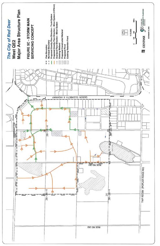
5.1 STORM WATER DRAINAGE
The West QE2 Major Area Structure Plan has been divided into separate storm drainage basins,
each with its own designed system of gathering surface water runoff as shown on Figures 5A, 5B
and 5C. The City has adopted a policy of restricting direct storm water discharges into the creeks
and river in order to limit potential damage associated with increased rates of runoff from urban
developments. The restrictions are imposed through the use of a storm water collection system
that incorporates water retention and detention facilities for the area. A number of “dry-ponds”
are designated for the plan area.
The City will also support alternative methods of storm water management, including the
incorporation of natural marshes or wetlands into the overall storm water system (i.e. green
infrastructure) where this can be accomplished without causing concerns for potential flooding.
5.2 SANITARY SEWER
The sanitary sewer system, shown on Figure 6, is divided into two drainage basins. This
collection system is designed to use a combination of sewage lift stations and gravity trunk mains
to direct all sewage to the highway crossings then to the wastewater treatment plant located at
the north end of the City along the river.
As new development occurs, the extension of existing trunk mains will permit all areas within the
boundaries of the West QE2 Major Area Structure Plan to be serviced. By over-sizing certain
mains areas outside the plan area can also be serviced.
West QE2 Major Area Structure Plan 23
May 2019West QE2 Major Area Structure Plan 24 May 2019
West QE2 Major Area Structure Plan   25
May 2019
West QE2 Major Area Structure Plan   26
May 2019
West QE2 Major Area Structure Plan   27
May 2019
5.3    WATER DISTRIBUTION

       The City of Red Deer obtains raw water from the Red Deer River. Water treatment is
       accomplished with two plants located at the river. The City’s water distribution system for the plan
       area consists of a combination of water pressure zones, booster pump stations, water reservoirs,
       and trunk mains to adequately distribute water to meet industrial and fire flow demands, as
       illustrated in Figure 7.

       Currently, the water distribution system presented in Figure 7 has sufficient storage capacity to
       serve the area in the event that maintenance on the main supply main is required. In the future,
       a secondary water connection to the West QEII area will be provided to serve lands within future
       annexation phases, but at this time there is adequate capacity for water distribution.

5.4    POWER DISTRIBUTION

       The servicing for the planed area will be transferred from Fortis Alberta to the Electric, Light, and
       Power Department (EL&P) of The City of Red Deer in 2010.

       EL&P will service the area with lines crossing Highway QEII from the Edgar Industrial Park. A
       potential electrical servicing concept is illustrated in Figure 8.

5.5    NATURAL GAS

       Natural gas servicing ultimately will extend from the south portion of the plan area. ATCO Gas
       has a gate station located within SE ¼ Section 25-38-28-4 and has extended their mains through
       NE ¼ Section 25-38-28-4.

       Development of the early phases is intended to be within the north portion of the plan area. This
       may present complications as ATCO Gas will require extensions of its mains through the SE ¼
       Section 36-38-28-4 to do so. This may be accommodated by using temporary alternate
       arrangements from existing small distribution systems within the area.

       In addition, there are existing lines in the plan area that would likely be able to be abandoned as
       development proceeds. Any servicing conflict would be examined in detail once phasing and
       development plans are finalized.

West QE2 Major Area Structure Plan                                                                 28
May 2019
West QE2 Major Area Structure Plan 29 May 2019
West QE2 Major Area Structure Plan   30
May 2019
6.0 PLAN IMPLEMENTATION

6.1    DEVELOPMENT PHASING

       This plan acknowledges that there is some existing development within the plan area. With
       regard to phasing of new development within the West QE2 MASP, development will occur in a
       logical, efficient manner. Phasing will consider existing infrastructure and services. Detailed
       phases of development will be illustrated within subsequent ASPs. In general, development of
       the plan area will commence in the northeast portion of the plan area and progress in a westerly
       and southerly manner.

6.2    AREA STRUCTURE PLANS

       The objectives of the West QE2 Major Area Structure Plan shall be implemented by further
       industrial area structure plans, with the exception of development presently accommodated within
       a County approved structure plan or outline plan existing prior to October 2007 (i.e. Burnt Lake
       Commercial Development NE ¼ 25-38-28-W4). As new quarter sections are being considered
       for future development, the developer is required to undertake an IASP which will include
       additional detail for the next development phase(s). Such detail will include:

           1)     a Phase 1 Environmental Site Assessment;
           2)     a layout of local roadways;
           3)     a servicing study; and
           4)     a development phasing plan.

       All subsequent area structure plans shall be prepared in accordance with the City of Red Deer’s
       Industrial Area Planning Guidelines & Standards.

6.3    AMENDMENTS TO THIS PLAN

       All plan amendments shall be prepared in accordance with the Industrial Area Planning
       Guidelines & Standards and shall follow the process outlined in the Municipal Government Act
       and the City's Industrial Area Planning Guidelines & Standards.

       Provided the intent of the Plan is maintained, minor adjustments to proposed land use
       boundaries or roadway and servicing alignments, etc. may be incorporated where necessary
       without amendment to this Plan.

       6.3.1    Future Planning

                Land use districts shall be in accordance with an Industrial Area Structure Plan. Parcels
                within the NE ¼ Section 25-38-28-4 may be exempt from requiring the preparation of an
                IASP prior to rezoning.

                Any rezoning requests for parcels within NE ¼ Section 25-38-28-4 shall be subject to
                review by Parkland Community Planning Services. The proposed land use shall be
                reviewed to ensure that the intent of the West QE2 MASP is maintained.

West QE2 Major Area Structure Plan                                                              31
May 2019
You can also read