ORANGE COUNTY PLANNING DIVISION - Orange County ...
←
→
Page content transcription
If your browser does not render page correctly, please read the page content below

ORANGE COUNTY
PLANNING DIVISION

2021-2 TAB 11a
AMENDMENT
2021-2-A-2-1
2010 - 2030 COMPREHENSIVE PLAN

BOARD OF COUNTY
COMMISSIONERS

SEPTEMBER 14, 2021
TRANSMITTAL PUBLIC HEARING

PREPARED BY:
ORANGE COUNTY COMMUNITY, ENVIRONMENTAL
AND DEVELOPMENT SERVICES

PLANNING DIVISION
COMPREHENSIVE PLANNING SECTION
Interoffice Memorandum
O~E
C~Y
GOVERNMENT
FLORID    ,\

  September 14, 2021

  TO:              Mayor Jerry L. Demings
                   -AND-
                   County Commissioners (BCC)
  FROM:           Alberto A. Vargas, MArch., Manager, Planning   Division~I
  THROUGH:        Jon V. Weiss, P.E., Director                         l.._,(· ~
                  Planning, Environmental, and Development Services Department

  SUBJECT:        2021-2 Regular Cycle Comprehensive Plan
                  Amendment 2021-2-A-2-1 (Grassmere)
                  Board of County Commissioners (BCC) Transmittal Public Hearing

  2021-2 Regular Cycle Comprehensive Plan Amendment 2021-2-A-2-1 is scheduled for a
  BCC transmittal public hearing on September 14, 2021. This amendment was heard by
  the Planning and Zoning Commission (PZC)/Local Planning Agency (LPA) at a transmittal
  public hearing on August 19, 2021.
  The report is also available under the Amendment Cycle section of the County's
  Comprehensive Planning webpage. See:
  http://www.orangecounMI .net/PlanningDevelopment/ComprehensivePlanning .aspx.
  The above-referenced 2021-2 Regular Cycle Amendment scheduled for consideration on
  September 14 entails a privately-initiated Future Land Use Map Amendment located in
  District 2. The privately-initiated map amendment involves a change to the Future Land
  Use Map (FLUM) for a property over 10 acres in size.
  Following the BCC transmittal public hearing, the proposed amendment will be
  transmitted to the Florida Department of Economic Opportunity (DEO) and other State
  agencies for review and comment. Staff expects to receive comments from DEO and/or
  the other State agencies in October 2021. Pursuant to 163.3184, Florida Statutes, the
  proposed amendment must be adopted within 180 days of receipt of the comment letter.
  The adoption hearings are tentatively scheduled before the LPA on November 18, 2021,
  and before the BCC on December 14, 2021.
  Any questions concerning this document should be directed to Alberto A. Vargas, MArch,
  Manager, Planning Division, at (407) 836-5802 or Alberto.Vargas@ocfl.net or Greg
  Golgowski, AICP, Chief Planner, Comprehensive Planning Section, at (407) 836-5624 or
  Gregory.Golgowski@ocfl.net.
2021-2 Regular Cycle Amendment 2021-2-A-2-1
BCC Transmittal Public Hearing
September 14, 2021
Page 2

AAV/sw
Enc: 2021-2 Regular Cycle Amendment 2021-2-A-2-1
     BCC Transmittal Staff Report

c:    Christopher R. Testerman, AICP, Deputy County Administrator
      Joel Prinsell, Deputy County Attorney
      Whitney Evers, Assistant County Attorney
      Roberta Alfonso, Assistant County Attorney
      Gregory Golgowski, AICP, Chief Planner, Planning Division
      Olan D. Hill, AICP, Assistant Manager, Planning Division
      Eric P. Raasch, AICP, Planning Administrator, Planning Division
      Read File
TABLE OF CONTENTS
INTRODUCTION ..............................................................................................................................Tab 1
REGULAR CYCLE AMENDMENT ..................................................................................................... Tab 2
  Privately‐Initiated Regular Cycle Future Land Use Map (FLUM) Amendment
    Amendment                                                                                                                             Page
      1.    2021‐2‐A‐2‐1                                                                                                                    1
                                            Rural Settlement 1/1 (RS 1/1) to Rural Settlement Low Density
            Grassmere PD
                                            (RSLD 2/1)

Community Meeting Summary………………………………………………………………………………………………………...Tab 3
Facilities Analysis……………………………………………………………………………………………………………………………..Tab 4
Transportation Analysis…………………………………………………………………………………………………………………...Tab 5
Environmental Analysis………………………………………………………………………………………………………………….…Tab 6

    BCC Transmittal                                                      1                                              September 14, 2021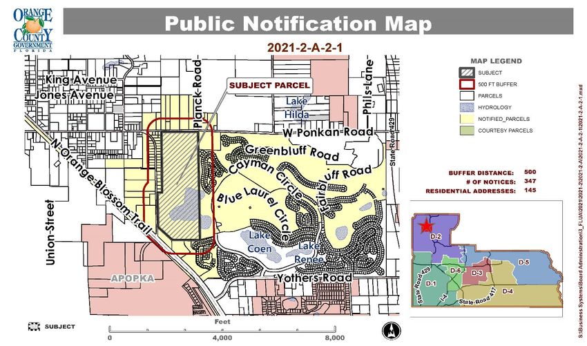
2021-2 Regular Cycle State-Expedited Review Comprehensive Plan Amendment
                                                                                                                    Privately-Initiated Future Land Use Map Amendment

                                      Concurrent Rezoning or                                                                                              General Location /                      Future Land Use Map Designation Future Land Use Map Designation           Zoning Map             Zoning Map
            Amendment Number                                        Owner                   Agent                      Tax ID Number(s)                                                                                                                                                                                  Acreage            Project Planner     Staff Rec          LPA Rec
                                        Substantial Change                                                                                                   Comments                                          FROM:                            TO:                      Designation FROM:       Designation TO:

                       District 5
                                                                                                                                                           2523 Junction Rd.;
                                                                                                                                                       Generally located north of
                                                                                                                                                        N. Orange Blossom Trl.                                                                                                                     PD (Planned
                                                                                    Thomas R. Sullivan, C/O                                                                                                                               Rural Settlement Low Density       PD (Planned                           124.08 gross ac./99.26                                       Do not Transmit
        2021-2-A-2-1 (Grassmere PD)          Expected          ECP Grassmere, LLC                                26-20-27-0000-00-020 (portion of)        east of Junction Rd.,                           Rural Settlement 1/1 (RS 1/1)                                                            Development                              Chris DeManche    Do not Transmit
                                                                                      GrayRobinson, P.A.                                                                                                                                            (RSLD 2/1)           Development District)                      net developable ac.                                              (6-0)
                                                                                                                                                              south of W.                                                                                                                            District)
                                                                                                                                                        Ponkan Rd., and west of
                                                                                                                                                              Cayman Cir.

                                                                                    ABBREVIATIONS INDEX: IND-Industrial; C-Commercial; O-Office; LDR-Low Density Residential; LMDR-Low-Medium Density Residential; MDR-Medium Density Residential; HDR-High Density Residential; PD-Planned Development; EDU-Educational; CONS-
                                                                                    Wetland/Conservation; PR/OS-Parks/Recreation/Open Space; OS-Open Space; R-Rural/Agricultural; RS-Rural Settlement; RS 1/1-Rural Settlement 1/1; RS 1/2-Rural Settlement 1/2; RSLD 2/1-Rural Settlement Low Density; GC-Growth Center; LP-Lake Pickett; PD-Planned
                                        ABBREVIATIONS INDEX:
                                                                                    Development; USA-Urban Service Area; WB-Water Body; CP-Comprehensive Plan; FLUM-Future Land Use Map; FLUE-Future Land Use Element; TRAN-Transportation Element; GOPS-Goals, Objectives, and Policies; OBJ-Objective; A-2-Farmland Rural District; R-CE-Country
                                                                                    Estate District; RCE-5-Rural Country Estate Residential District; PD-Planned Development District; PD-RP-Planned Development-Regulating Plan; PD-RS-Planned Development-Rural Settlment; SR-State Road; AC-Acres

Updated on 9/10/2021                                                                                                                                       2021-2-A-2-1 Regular Cycle State Expedited Amendment - Summary Chart                                                                                                                                                           Pg. 1 of 1
2021 SECOND REGULAR CYCLE
              AMENDMENT TO THE 2010-2030
                 COMPREHENSIVE PLAN
              TRANSMITTAL PUBLIC HEARING

INTRODUCTION
This is the Board of County Commissioners (BCC) transmittal staff report for the Second
Regular Cycle Amendment 2021-2-A-2-1 to the Future Land Use Map (FLUM) and
Comprehensive Plan (CP). This amendment was heard by the Local Planning Agency
(LPA) during a transmittal public hearing held on August 19, 2021, and will go before the
BCC for a transmittal public hearing on September 14, 2021.

The above-referenced 2021-2 Regular Cycle Amendment entails a privately-initiated map
amendment located in District 2. Since this is the transmittal stage for this amendment,
there will be a second round of public hearings for adoption after the Florida Department
of Economic Opportunity (DEO) and other State agencies complete their review of the
proposed amendment and provide comments, expected in October 2021. Adoption public
hearings are tentatively scheduled before the LPA on November 18, 2021 and the BCC
on December 14, 2021.

Once the Regular Cycle amendment has been adopted by the BCC, it will become
effective 31 days after DEO notifies the County that the plan amendment package is
complete. This amendment is expected to become effective in January 2022, provided no
challenges are brought forth for the amendment.

Any questions concerning this document should be directed to Alberto A. Vargas, MArch.,
Manager, Planning Division, at (407) 836-5802 or Alberto.Vargas@ocfl.net, or Gregory
Golgowski, AICP, Chief Planner, Comprehensive Planning Section, at (407) 836-5624 or
Gregory.Golgowski@ocfl.net.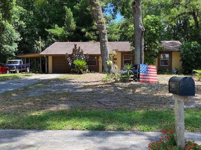
Orange County Planning Division                                               BCC Transmittal Staff Report
Chris DeManche, Project Planner                                                 Amendment 2021‐2‐A‐2‐1

                                                                                            Applicant/Owner:
                                                                                            Thomas R Sullivan, P.A.,
                                                                                            GrayRobinson, P.A./ECP
                                                                                            Grassmere, LLC
                                                                                            Location: Generally
                                                                                            located north of N.
                                                                                            Orange Blossom Trail,
                                                                                            east of Junction Road,
                                                                                            south of W.Ponkan
                                                                                            Road, and west of
                                                                                            Cayman Circle
                                                                                            Existing Use:
                                                                                            Undeveloped land
                                                                                            Parcel ID Numbers:
                                                                                            26‐20‐27‐0000‐00‐020
                                                                                            (portion of)
                                                                                            Tract Size: 124.08 gross
                                                                                            acres (99.26 net acres)

 +The following meetings and hearings have been held    Project Information
 for this proposal:

                                                        Request: Rural Settlement 1/1 (RS 1/1) to Rural Settlement Low
 Report/Public Hearing               Outcome
                                                        Density Residential (RSLD 2/1)

                             Virtual Community          Proposed Development Program: Up to 179 single‐family
       Community Meeting
                             meeting 4 residents in     detached dwelling units.
       May 18, 2021          attendance ‐ Neutral
                             Recommend Do Not           Public Facilities and Services: Please the see Public Facilities
       Staff Report
                             Transmit                   Analysis Appendix for specific analysis on each public facility.
       LPA Transmittal       Recommend Do Not           Environmental: The site is located within the geographical
       August 19, 2021       Transmit (6‐0)             limits of the Wekiva Study Area, as established by the Wekiva
                                                        Parkway and Protection Act.
                                                        Schools: Capacity is currently not available for the proposed
       BCC Transmittal          September 14, 2021
                                                        179 single‐family detached dwelling units, but expected to be
                                                        relieved at the elementary and middle school levels in 2022.
       State Agency                                     Transportation: The subject property is not located within the
                                  Octoberr 2021
       Comments                                         County’s Alternative Mobility Area or located along a
                                                        backlogged/constrained facility or multimodal corridor. The
                                                        proposed use will generate 177 pm peak hour trips resulting in a
       LPA Adoption             November 18, 2021
                                                        net increase of 76 pm peak hour trips.

                                                        Concurrent Rezoning: A Change Determination Review request is
       BCC Adoption             December 14, 2021       expected and will be considered with the proposed future land
                                                        use map amendment at Adoption.

September 14, 2021                           Commission District 2                                        Page | 1
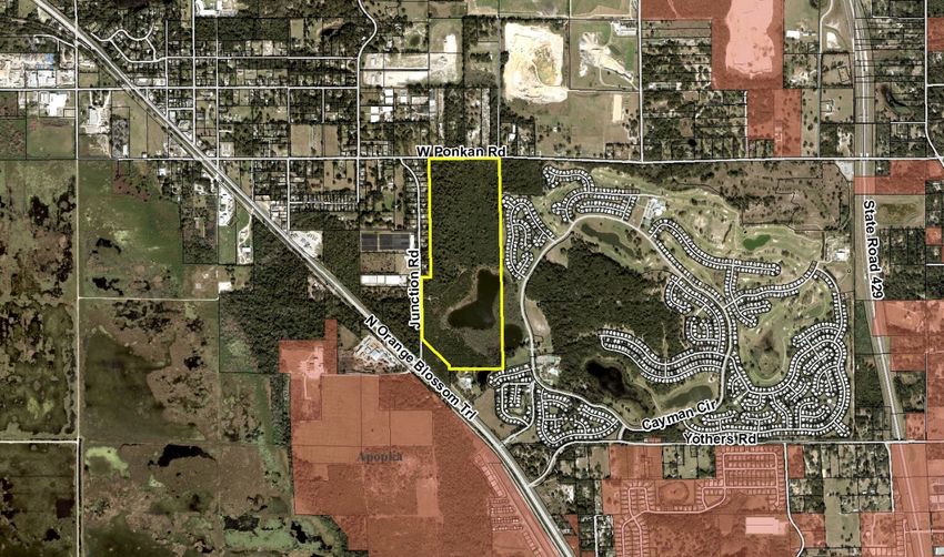
Orange County Planning Division                           BCC Transmittal Staff Report
Chris DeManche, Project Planner                             Amendment 2021‐2‐A‐2‐1

AERIAL

September 14, 2021                Commission District 2                      Page | 2
Orange County Planning Division                           BCC Transmittal Staff Report
Chris DeManche, Project Planner                             Amendment 2021‐2‐A‐2‐1

FUTURE LAND USE ‐ CURRENT
                                                                         Current Future Land
                                                                         Use Designation:
                                                                         Rural Settlement 1/1
                                                                         (RS 1/1)

                                                                         Rural Settlement
                                                                         Boundary Line:

FUTURE LAND USE ‐ PROPOSED
                                                                         Proposed Future Land
                                                                         Use Designation:
                                                                         Rural Settlement Low
                                                                         Density (RSLD 2/1)

                                                                         Rural Settlement
                                                                         Boundary Line:

September 14, 2021                Commission District 2                       Page | 3
Orange County Planning Division                           BCC Transmittal Staff Report
Chris DeManche, Project Planner                             Amendment 2021‐2‐A‐2‐1

ZONING – CURRENT
                                                                       Current Zoning District:
                                                                       PD (Planned
                                                                       Development District)
                                                                       Existing Uses:
                                                                       North: Single‐family
                                                                       detached dwelling
                                                                       units/vacant parcels

                                                                       South: Vacant parcel,
                                                                       church and mobile
                                                                       homes.

                                                                       East: Mobile homes
                                                                       (Zellwood Station)

                                                                       West: Single‐family
                                                                       detached dwelling units,
                                                                       vacant parcels

September 14, 2021                Commission District 2                       Page | 4
Orange County Planning Division BCC Transmittal Staff Report
Chris DeManche, Project Planner Amendment 2021‐2‐A‐2‐1
Staff Recommendation
Future Land Use Map Amendment 2021‐2‐A‐2‐1: Make a finding that the information contained
in the application for the proposed amendment is not sufficiently complete; that the proposed
amendment does not have the potential to be found in compliance, as defined by Section
163.3184(1)(b), Florida Statutes; and recommend to the Board of County Commissioners that
Amendment 2021‐2‐A‐2‐1 NOT BE TRANSMITTED to the state reviewing agencies.
Analysis
1. Background Development Program
The applicant, Thomas Sullivan, representing ECP Grassmere, LLC., has requested to change the
Future Land Use Map (FLUM) designation of the 124.08 gross acre site from Rural Settlement 1/1 (RS
1/1) to Rural Settlement Low Density (RSLD 2/1).
The subject property is located at 2523 Junction Road, north of N. Orange Blossom Trail, east of
Junction Road, south of W. Ponkan Road, and west of Cayman Circle. Surrounding properties include
vacant parcels, single‐family detached dwelling units, a manufactured home community (Zellwood
Station), and a church.
The subject property is located within the Zellwood Rural Settlement and is part of the Zellwood
Preservation District. The basis for rural settlements is to recognize existing communities within the
Rural Service Area which are the focal point of rural activity. The Zellwood Rural Settlement is
characterized as a rural town, with residential and neighborhood‐serving commercial uses generally
concentrated in the area bounded by King Avenue, N. Orange Blossom Trail, West Ponkan Road, and
Round Lake Road.
The Zellwood Preservation District represents an existing historical and cohesive residential
community. The boundaries of the preservation district coincide with the boundaries of the Zellwood
Rural Settlement. In order to voluntarily annex any property or properties located within the Zellwood
Preservation District, the Orange County Charter, Sec. 505 provides that:
Voluntary annexation in a preservation district may occur only if it is approved by a majority of
the board of county commissioners after an advertised public hearing and by a majority of the
registered electors residing within the boundaries of the preservation district in which the
property or properties lie and voting on the question. The vote by the registered electors
residing within the preservation district shall be conducted in accordance with Florida laws
pertaining to annexation elections, and the board of county commissioners may adopt
regulations and procedures to implement this method of voluntary annexation.
The subject property is vacant and consists of 99.26 acres of developable land and approximately
24.82 acres of wetlands. The project site represents a portion of an overall parcel comprised of 129.08
acres. The 5.00 acres not subject to the requested FLUM amendment are located contiguous to, and
south of the project site along N. Orange Blossom Trail, and were approved for a land use designation
change from Rural Settlement 1/1 (RS 1/1) to Commercial (C) Rural Settlement (RS) as part of FLUM
Amendment 2019‐2‐S‐2‐5, approved by the Board of County Commissioners on February 11, 2020.
September 14, 2021 Commission District 2 Page | 5Orange County Planning Division BCC Transmittal Staff Report Chris DeManche, Project Planner Amendment 2021‐2‐A‐2‐1 The subject property is zoned P‐D (Planned Development) as part of the Grassmere Reserve PD Land Use Plan (LUP). The LUP for the entire PD was approved for a total of 100 single‐family dwelling units at a density of 1 dwelling unit per acre on 101 net developable acres. The subject property was subsequently approved for a Preliminary Subdivision Plan (PSP‐19‐07‐244) consisting of 98 single‐ family dwelling units on 99.26 net developable acres by the Board of County Commissioners on April 21, 2020. The proposed RSLD 2/1 future land use designation is intended to recognize existing development patterns and rural and suburban lots at 2 DU/AC. The applicant is proposing to increase the total number of single‐family detached dwelling units from 98 to 179. Community Meeting In lieu of a traditional in‐person community meeting, a virtual community meeting was held on the evening of May 18, 2021. A total of 347 notices were mailed to properties within a 500‐foot radius of the project site. The community meeting discussion centered on the applicant’s proposed plan to amend the site’s future land use designation from RS 1/1 to RSLD 2/1, in order to increase the total number of single‐family detached dwelling units from 98 to 179. A total of four members of the public attended, all of whom appeared to reside within the vicinity of the project site. The applicant presented graphics detailing the subdivision layout of the approved preliminary subdivision plan (PSP‐ 19‐07‐244) for 98 dwelling units, and a graphic delineating a proposed subdivision layout for 179 dwelling units. Questions from the public included a range of topics that included concerns over site connection to water/sewer from the City of Apopka, the location and number of access points for the site, the estimated price range and market sector of the housing project, and the presence of natural and enhanced buffering on the site. Overall, the attendees did not express support for or against the proposed FLUM amendment. The tone of the meeting was neutral. 2. Future Land Use Map Amendment Analysis Consistency The requested FLUM amendment appears to be inconsistent with the applicable Goals, Objectives, and Policies of the Comprehensive Plan. The subject property is located within the Zellwood Station Rural Settlement. As mentioned above, the applicant is seeking the (RSLD 2/1) FLUM designation in order to increase the number of single‐family detached dwelling units from 98 to 179. Staff finds the request inconsistent with Future Land Use Element Policy FLU1.1.4 H, which presents Future Land Use designations that are available for use in Rural Settlements. The requested designation of Rural Settlement Low Density (RSLD 2/1) is intended to recognise existing development patterns and rural and suburban lots at 2 DU/AC. However, this category may be suited for new residential projects abutting urban development in adjacent municipalities. The subject property does not abut urban development in an adjacent municipality. Therefore the request for a density increase is inconsistent with the Comprehensive Plan. September 14, 2021 Commission District 2 Page | 6
Orange County Planning Division                                           BCC Transmittal Staff Report
Chris DeManche, Project Planner                                             Amendment 2021‐2‐A‐2‐1

   Staff finds the request inconsistent with Future Land Use Element OBJ FLU6.2, which states Rural
   Settlements provide for a rural residential lifestyle, and were intended to recognize and preserve
   existing development patterns at the time the Comprehensive Plan was adopted in 1991. The
   proposed increase in density from one dwelling unit per acre to two dwelling units per acre does not
   preserve the rural residential lifestyle intended by the creation of Rural Settlement or the existing
   development patterns at the time of the Comprehensive Plan’s adoption in 1991.

   Staff finds the request inconsistent with Future Land Use Element Policy FLU6.2.2, which states every
   effort shall be made to preserve the existing character of the Christmas, Clarcona, Gotha, Tangerine,
   and Zellwood Rural Settlements as part of Orange County's heritage and historic preservation. The
   proposed density increase associated with the RSLD 2/1 designation would disrupt the existing
   character and neighborhood development patterns of the Zellwood Rural Settlement. The majority of
   properties adjacent to or within close proximity of the project site maintain future land use
   designations of a similar or lower density than the current future land use designation of the site.
   Parcels located to the west maintain the RS 1/1 (1 du/ac) designation, while parcels to the north
   maintain the Rural/Agricultural (1 du/10ac) designation. The only exception to these nearby density
   allowances is the Zellwood Station PD located east of the project site. The Zellwood Station PD is
   located within the Zellwood Station Rural Settlement and Zellwood Station Preservation District, and
   is largely comprised of manufactured homes and includes a golf course and substantial open space
   areas. The site maintains future land use designations of Low Density Residential (LDR) (4 du/ac) and
   Parks and Recreation/Open Space (PR/OS). Zellwood Station was approved for residential
   development entitlements beginning on October 30, 1973, prior to the adoption of the Orange County
   Comprehensive Plan in 1991 and the subsequent creation of Rural Settlements, which recognize and
   preserve communities that existed prior to the Comprehensive Plan. The Zellwood Station PD is
   approved for a total of 2021 units at a density of 2.6 dwelling units per acre. The presence of existing
   higher density developments within Rural Settlements such as the Zellwood Station PD that predates
   the County Comprehensive Plan, should not serve as an impetus for the allowance of new higher
   density development to occur within Rural Settlements.

   Staffs finds the request inconsistent with Future Land Use Element Policy FLU6.2.5, which states the
   permitted densities and intensities of land use within the Rural Settlements shall maintain their rural
   character. Factors to be considered shall include lot size, open space and views, tree canopy, building
   location and orientation, and compatibility with existing land uses. Density and Floor Area Ratio (FAR)
   calculation shall be defined as the language specified in Future Land Use Element Policy FLU1.1.2(B).
   The proposed FLUM amendment would allow for the density of the project site per acre to double,
   and would thus impact the existing rural character of the Zellwood Rural Settlement.
   The proposed FLUM amendment is inconsistent with Future Land Use Element Policy FLU6.2.8, which
   states residential development in a Rural Settlement may be permitted up to two (2) dwelling units
   per acre in limited areas that are adjacent to higher density or intensity urban development located
   in adjacent municipal jurisdictions, provided site design standards are provided to ensure
   compatibility with the Rural Settlement. This provision is intended to serve as a buffer and transition.
   The Future Land Use designation of Rural Settlement Low Density Residential shall be restricted to no
   more than 2 DU/AC. Parcels greater than 25 Acres must be approved as a PD. Higher density shall only
   be recognized if it applies to parcels developed prior to the adoption of the Comprehensive Plan
   (1991), are otherwise vested from compliance with the Plan’s defined densities or involve parcels that
   are adjacent to higher density or intensity urban development located in adjacent municipal
   jurisdictions. Adjacency requires a minimum of 25% contiguity of the property line. Such increased

September 14, 2021                      Commission District 2                                    Page | 7
Orange County Planning Division                                           BCC Transmittal Staff Report
Chris DeManche, Project Planner                                             Amendment 2021‐2‐A‐2‐1

   density shall not be an impetus for the provision of central services within Rural Settlements. The
   project site is not located adjacent to higher density or intensity urban development located in an
   adjacent municipal jurisdiction. The project site is adjacent to a single parcel located to the south and
   across N. Orange Blossom Trail in the City of Apopka. That parcel totals 9.86 acres in size and is
   improved with only one single‐family detached dwelling unit. Additionally, the project site does not
   meet the 25% contiguity requirement, as it only maintains a limited contiguity of 6.7% with this parcel
   located in the City of Apopka.
   Compatibility
   Future Land Use Element Policy FLU8.2.1 requires land use changes be compatible with existing
   development and the development trend in the area. The proposed FLUM amendment would result
   in an increase to the project site’s density to allow up to two dwelling units per acre. This density
   increase is not compatible with existing development and the development trend in the areas within
   close proximity of the project site. The only existing development within close proximity of the project
   site with a comparable density level is the Zellwood Station PD. As noted previously, the Zellwood
   Station PD is approved for a density of 2.6 dwelling units per acre and 2021 lots. These approvals
   predate the inception of the County Comprehensive Plan in 1991. The presence of Zellwood Station
   does not serve as an impetus to permit additional higher density development and is not supported
   by any specific Comprehensive Plan policy for properties located within Rural Settlements.
   Future Land Use Element Policy FLU8.2.11 states compatibility may not necessarily be determined to
   be a land use that is identical to those uses that surround it. Other factors may be considered, such
   as the design attributes of the project, its urban form, the physical integration of a project and its
   function in the broader community, as well its contribution toward the Goals and Objectives in the
   CP. The CP shall specifically allow for such a balance of considerations to occur. The proposed FLUM
   amendment to RSLD 2/1 does not contribute to toward the Goals and Objectives in the
   Comprehensive Plan. Furthermore, the request is not compatible with the specific criteria outlined in
   Future Land Use Element Policy FLU6.2.8, allowing up to two (2) dwelling units per acre in limited
   areas that are adjacent to higher density or intensity urban development located in adjacent
   municipal jurisdictions. The lack of existing higher density and intensity urban development on
   adjacent properties located within the City of Apopka, and the site’s limited contiguity of 6.7% does
   not meet the adjacency requirement of 25% contiguity.
   Per Open Space Element Policy OS1.3.4, all new residential developments located entirely or partially
   in the Wekiva Study Area are required to cluster to the maximum extent feasible to preserve open
   space which, as mandated in Open Space Element Policy OS1.3.2, shall exclude water bodies,
   wetlands, residential lots, street rights‐of‐way, parking lots, impervious surfaces, and active
   recreation areas. Minimum required open space may include permeable stormwater management
   areas using Best Management Practices. The minimum required quantity of open space within a
   development site shall be calculated over the net developable area of a parcel, which is defined as
   the total area of a parcel less wetlands and natural water bodies. Non‐developable areas, including
   wetlands and natural water bodies, are recognized as protected features but shall not be credited
   toward the minimum open space requirement.
   The subject property is located within the Wekiva Study Area, and as stipulated in Open Space
   Element Policy OS1.3.6(B)(3), development with densities greater than one unit per acre (1du/ac) in
   a development with an overall size greater than 100 acres (a density and acreage applicable to the
   requested amendment)– open space shall be 70% or greater.

September 14, 2021                      Commission District 2                                     Page | 8
Orange County Planning Division                                               BCC Transmittal Staff Report
Chris DeManche, Project Planner                                                 Amendment 2021‐2‐A‐2‐1

   Division Comments: Environmental, Public Facilities, and Services
   Environmental: The site is located within the geographical limits of the Wekiva Study Area, as
   established by the Wekiva Parkway and Protection Act, Section 369.316 F.S. Special area regulations
   apply. Regulations include, but are not limited to: septic tank criteria, open space requirements,
   stormwater treatment, upland preservation, setbacks related to karst features and the watershed,
   and aquifer vulnerability. These requirements may reduce the total net developable acreage. In
   addition to the state regulations, local policies are included in the Orange County Comprehensive Plan
   2010‐2030, Future Land Use Element (but not limited to) Objective FLU6.6 Wekiva and the related
   policies.
   Conservation Area Determination ‐ The project site was included in a completed Orange County
   Conservation Area Determination CAD‐19‐03‐038 with a certified wetland boundary survey approved
   by the Environmental Protection Division on August 9, 2019 to expire August 9, 2024. The lake and
   edge wetlands are classified as a Class I wetland/surface water and cover 23.07 acres.

   Conservation Area Impacts ‐ Any wetland encroachments will require submittal of an application for
   a Conservation Impact Permit to the Orange County Environmental Protection Division as outlined in
   Chapter 15, Article X Wetland Conservation Areas.

   Wekiva Study Area wetland buffers ‐ This site requires 50‐foot wetland buffers. All plans shall show a
   50‐foot wetland buffer (alternative protections may also be considered) located landward of the
   approved wetland line with natural vegetation retained. Wetland buffers will be labeled “50‐foot
   Undisturbed Natural Buffer”. Comprehensive Plan Goal C2 policy C2.2.1 An upland buffer a minimum
   of 25 feet and an average of 50 feet shall be required for all Class I, Class II or Class III wetland systems/
   conservation areas.

   Clearing Limitation ‐ No construction, clearing, filling, alteration or grading is allowed within or
   immediately adjacent to a conservation area (wetland or wetland buffer) without first obtaining a
   wetland impact permit approved by the county and obtaining other applicable jurisdictional agency
   permits.

   Lake Boundary – In addition the approved wetland boundary survey line, all plans shall depict and
   label Lake Grassmere and indicate the Normal High‐Water Elevation (NHWE) of 113.08 feet (NAVD).

   Watercraft Restriction – Lake Grassmere shall be limited to non‐motorized watercraft per previous
   reviews of the DRC in response to public comments.

   Conservation Easement/Tracts ‐ All conservation areas (as defined in Chapter 15 Orange County Code)
   and their wetland setbacks shall be designated as conservation easements according to Orange
   County Code Chapter 34‐152(f)(1)b. Designate the ownership / maintenance by the Home Owner’s
   Association and the development rights dedicated to Orange County.

   Water Quality Protection Design ‐ A pollution abatement swale upland of the Lake Grassmere
   lakeshore wetland buffer and the direction of drainage shall be shown on all plans in that area. Areas
   that drain away from the lakeshore do not require a swale. The swale shall be labeled as a pollution
   abatement easement and included in the Tract/Easement Data Table on the PSP or DP.

September 14, 2021                        Commission District 2                                       Page | 9
Orange County Planning Division                                           BCC Transmittal Staff Report
Chris DeManche, Project Planner                                             Amendment 2021‐2‐A‐2‐1

   Stormwater Runoff ‐ All development is required to treat stormwater runoff for pollution abatement
   purposes. Discharge that flows directly into wetlands or surface waters without pretreatment is
   prohibited. Reference Orange County Code Sections 30‐277 and 30‐278.

   Habitat Protection ‐ Development of the subject property shall comply with all state and federal
   regulations regarding wildlife and plants listed as endangered, threatened, or species of special
   concern. The applicant is responsible for determining the presence of listed species and obtaining
   any required habitat permits from the U.S. Fish and Wildlife Service (USFWS) and/or the Florida Fish
   & Wildlife Conservation Commission (FWC). Previous gopher tortoise permitting status needs to
   coordinated with the FWC.

   Existing Dock ‐ Renovation of the deteriorated existing dock will require additional permitting, contact
   the Environmental Protection Division of Orange County. Approval of this request does not constitute
   approval of a permit for the construction of an overlook dock or other similar structure within the
   wetland or below the normal high‐water elevation. In accordance with Chapter 15, Article IX,
   Construction of Boat Dock Ordinance, the boat dock requires additional permitting and action by the
   Board of County Commissioners.

   Solid Waste Management Facility Proximity ‐ The county comprehensive policy plan states: “The
   County shall not support the siting of developments at urban residential densities that would be
   adversely impacted by existing solid waste management activities.” This site is within one‐half mile
   south of an existing Class III landfill from which odor complaints have been received. The covenants,
   conditions, and restrictions (CC&Rs) shall contain notification of the proximity to an existing landfill
   and reported odor complaints.

   Prior Agricultural Use Documentation ‐ This property has a prior agricultural land use that may have
   resulted in soil and/or groundwater contamination due to due to spillage of petroleum products,
   fertilizer, pesticide or herbicide. A Phase I Environmental Site Assessment (ESA) report dated February
   26, 2019 was submitted with the preliminary subdivision plan that revealed no Recognized
   Environmental Conditions (RECs). It stated that, while no Recognized Environmental Conditions (RECs)
   were identified, there is a non‐REC Business Environmental Risk of historic agricultural use for citrus
   crop production and tree farming operations over several decades. The project is partially located
   within one of several zones associated with ethylene dibromide (EDB) groundwater contamination,
   therefore pursuant to Chapter 62‐524, F.A.C. New Potable Water Well Permitting, any new potable
   wells constructed are required to comply with the regulatory guidelines. Irrigation wells shall use
   reclaimed water if available to avoid using local groundwater.

   No activity will be permitted on the site that may disturb, influence or interfere with: areas of soil or
   groundwater contamination, any remediation activities, or within the hydrological zone of influence
   of any contaminated area, unless prior approval has been obtained through Florida Department of
   Environmental Protection (FDEP) and such approval has been provided to the Environmental
   Protection Division (EPD) of Orange County. An owner/operator who exacerbates any existing
   contamination or does not properly dispose of any excavated contaminated media may become liable
   for some portion of the contamination pursuant to the provisions in section 376.308, F.S.

September 14, 2021                      Commission District 2                                   Page | 10
Orange County Planning Division                                           BCC Transmittal Staff Report
Chris DeManche, Project Planner                                             Amendment 2021‐2‐A‐2‐1

   Adjacent Uses – This site has a wildlife animal facility adjacent to the north, and other adjacent uses
   include an active vegetative mulch processing facility to the southwest across US 441, two landfills
   (Class III construction, demolition and vegetative debris) are within one‐half mile to the north, a large
   soil excavation operation is 0.3 miles to the north, and landscape nurseries are located to the west.
   These facilities may periodically create odors, noise, and/or dust depending upon weather and
   operational circumstances.

   Managed Land Proximity ‐ The Lake Apopka Restoration Area is located approximately 0.5 miles west.
   The applicant / owner has an affirmative obligation to expressly notify potential purchasers, builders,
   and/or tenants of this development, through an appropriate mechanism, including a conspicuous
   note on the plat and/or a recorded restrictive covenant, as applicable, that the adjacent land use
   includes publicly managed property. The notice shall indicate that the adjacent property will require
   the use of resource management practices that may result in periodic temporary conditions that may
   limit outdoor activities. These practices will include, but not be limited to, ecological burning,
   pesticide and herbicide usage, exotic plant and animal removal, usage of heavy equipment and
   machinery, and other practices as may be deemed necessary for proper resource management.

   This review does not release the applicant from complying with all other Federal, State, and Local
   rules and regulations. If this review conflicts with those of any other Agency, Department or Division,
   the permittee must comply with the most stringent requirements.

   Schools: The applicant submitted a formal school capacity determination to OCPS (OC‐21‐021).
   Capacity is not available for the proposed 179 single‐family dwelling units. Each school serving
   students within the geographic area of the project site is currently over capacity. The proposal would
   contribute students that would take these schools further over their capacities by the following:
   Zellwood Elementary School (11 seats), Wolf Lake Middle School (8 seats), and Apopka High School
   (11 seats). However, Zellwood Elementary and Wolf Lake Middle School are currently scheduled for
   relief from overcapacity, including the project’s contributions, in 2022.

                                    Analysis of Proposed Development
    Students Generated                    15.471                7.695                       10.611
    Adjusted Utilization                 111.8%                144.0%                       107.9%
    PASS/FAIL                              FAIL*                FAIL*                        FAIL
    Number of Seats to Mitigate           11.471                7.695                       10.611

   *School scheduled for relief in 2022.

   Transportation:
   Land Use Scenario                        PM Pk.           % New Trips              New PM Pk.
                                            Hr. Trips           Trips                  Hr. Trips
   Existing Use: 98 SF d/u’s                101                 100%                      101
   Proposed Use: Up to 179 SF d/u’s          177                100%                      177
   Net New Trips (Proposed Development less Allowable Development): 76

   Future Roadway Network
   Road Agreements: None

September 14, 2021                      Commission District 2                                   Page | 11
Orange County Planning Division BCC Transmittal Staff Report
Chris DeManche, Project Planner Amendment 2021‐2‐A‐2‐1
Planned and Programmed Roadway Improvements: The LRTP includes the planned extension and
expansion of Sadler Road from Orange Blossom Trail Road to Rock Springs Road. The improvement is
listed as a partnership road and is not currently funded for any phase of improvement
Right of Way Requirements: None
Summary
The applicant is requesting to change 124.08 acres from RS 1/1 to RSLD 2/1 to increase density to
allow for up to an additional 81 single family detached dwelling units for a total of 179 single family
detached dwelling units.
Analysis of the project trips from the currently approved under future land use versus the proposed
use indicates that the proposed development will result in an increase in the number of pm peak trips
and therefore impact the area roadways. However, based on the Concurrency Management System
Database, several roadways within the project impact area operate at acceptable levels of service
and capacity is available to be encumbered.
The subject property is not located within the County’s Alternative Mobility Area.
The subject property is not located along a backlogged/constrained facility or multimodal
corridor.
The allowable development based on the approved future land use will generate 101 pm peak
hour trips.
The proposed use will generate 177 pm peak hour trips resulting in a net increase of 76 pm peak
hour trips.
The subject property is located northeast of Orange Blossom Trail and W. Ponkan Road. Based on
the Concurrency Management System (CMS) database dated February 25, 2021, one roadway
currently operates at Level of Service F and capacity is not available to be encumbered. All other
roadway segments within the project impact area operate at acceptable levels of service. This
information is dated and is subject to change.
An analysis of existing conditions reveals that all roadway segments within the study area are
currently operating at adequate LOS.
Analysis of projected conditions 2025 base conditions indicates that the segment of Orange
Blossom Trail from W. Ponkan Road to Sadler Road is projected to be deficient due to background
traffic growth. The proposed FLU amendment is not considered significant on the deficient
roadway segment.
Analysis of projected conditions 2040 base conditions indicates that the segments of Orange
Blossom Trail from the Western Beltway to Sadler Road are projected to be deficient due to
background traffic growth. The proposed FLU amendment is not considered significant on the
deficient roadway segment.
The development will undergo further evaluation and will be required to mitigate capacity
deficiencies on the transportation network in accordance with the requirements of the Orange
County Concurrency Management System.
Final permitting of any development on this site will be subject to review and approval under capacity
constraints of the county’s Transportation Concurrency Management System. Such approval will not
exclude the possibility of a proportionate share payment in order to mitigate any transportation
deficiencies. Finally, to ensure that there are no revisions to the proposed development beyond the
September 14, 2021 Commission District 2 Page | 12Orange County Planning Division BCC Transmittal Staff Report
Chris DeManche, Project Planner Amendment 2021‐2‐A‐2‐1
analyzed use, the land use will be noted on the County’s Future Land Use Map or as a text amendment
to the Comprehensive Policy Plan.
Utilities
The subject site is located in the City of Apopka’s potable water, wastewater and reclaimed water
service areas.
3. Policy References
Future Land Use Element
OBJ FLU6.2 RURAL SETTLEMENTS. Rural Settlements provide for a rural residential lifestyle.
In some instances, Rural Settlements allow a transition of rural areas adjacent to
the Urban Service Area while avoiding development in active agricultural areas.
Rural Settlements were intended to recognize and preserve existing development
patterns at the time the Comprehensive Plan was adopted in 1991. The creation
of Rural Settlements recognized the need to maintain agricultural areas and rural
uses in the Rural Service Area, while providing for rural communities.
FLU6.2.1 The following Rural Settlements shall be designated on the Future Land Use Map
to meet the desire for a rural lifestyle. No new Rural Settlements or expansions
to the existing Rural Settlement boundaries shall occur.
Rural Settlements
Bithlo North Christmas
Bridle Path Otter Lake
Christmas Paradise Heights
Clarcona Rainbow Ridge
Corner Lake Sunflower Trail/Seaward
Plantation
Gotha Tangerine
Lake Avalon Tildenville
Lake Hart/Lake Wedgefield
Whippoorwill
Lake Mary Jane West Windermere
Lake Pickett Zellwood
North Zellwood Station
Apopka/Wekiva
Rural Settlements were implemented to recognize communities that existed at
the time of the 1991 Comprehensive Policy Plan adoption. The intent of the
prohibition of expansions of existing or the creation of new rural settlements is
to focus development within the County’s Urban Service Area and discourage the
proliferation of extended Rural Settlement boundaries. In addition, this policy will
September 14, 2021 Commission District 2 Page | 13Orange County Planning Division BCC Transmittal Staff Report
Chris DeManche, Project Planner Amendment 2021‐2‐A‐2‐1
allow time for vacant and committed lands within existing Rural Settlements to
develop as a means of satisfying this style of living.
FLU6.2.2 Every effort shall be made to preserve the existing character of the Christmas,
Clarcona, Gotha, Tangerine, and Zellwood Rural Settlements as part of Orange
County's heritage and historic preservation. Rural Settlements may be designated
as Preservation Districts for the purposes of municipal annexation pursuant to
the Orange County Charter, Article V.
FLU6.2.5 The permitted densities and intensities of land use within the Rural Settlements
shall maintain their rural character. Factors to be considered shall include lot size,
open space and views, tree canopy, building location and orientation, and
compatibility with existing land uses. Density and Floor Area Ratio (FAR)
calculation shall be defined as the language specified in Future Land Use Element
Policy FLU1.1.2(B).
FLU6.2.6 The Future Land Use Map shall reflect the permitted densities of development
within the Rural Settlements. Clustering of units with dedicated open space shall
be allowed so long as the overall density does not exceed that specified on the
Future Land Use Map. Density and Floor Area Ratio (FAR) calculations shall be
defined as the language specified in the Future Land Use Element Policy
FLU1.1.2(B). (Added 8/92, Ord. 92‐24; Amended 8/93, Ord. 93‐19; Amended
6/10, Ord. 10‐07, Policy 1.1.11)
Clustering shall be supported to maintain the rural character through
preservation of open space and lot layout and design. Generally recognized and
accepted conservation subdivisions can be used where they minimize impacts on
areas with rural character provided their use is consistent with the overall intent
of Rural Settlement boundaries.
Clustering, with permanent protection of open space, shall be encouraged or
required for all new development and redevelopment within the Wekiva Study
Area, based on location, i.e., Urban Service Area, Rural Service Area, Rural
Settlement, Growth Center and overall project acreage. The County shall evaluate
incentives to further the implementation of open space preservation and
maximum impervious surface ratios and include these in the Land Development
Code.
FLU6.2.8 Residential development in a Rural Settlement may be permitted up to two (2)
dwelling units per acre in limited areas that are adjacent to higher density or
intensity urban development located in adjacent municipal jurisdictions,
provided site design standards are provided to ensure compatibility with the
Rural Settlement. This provision is intended to serve as a buffer and transition.
The Future Land Use designation of Rural Settlement Low Density Residential
shall be restricted to no more than 2 DU/AC. Parcels greater than 25 Acres must
be approved as a PD. Higher density shall only be considered if existing or vested
development. Adjacency requires a minimum of 25% contiguity. Such increased
September 14, 2021 Commission District 2 Page | 14Orange County Planning Division BCC Transmittal Staff Report
Chris DeManche, Project Planner Amendment 2021‐2‐A‐2‐1
density shall not be an impetus for the provision of central services within Rural
Settlements.
OBJ FLU8.2 COMPATIBILITY. Compatibility will continue to be the fundamental consideration
in all land use and zoning decisions. For purposes of this objective, the following
polices shall guide regulatory decisions that involve differing land uses.
FLU8.2.1 Land use changes shall be required to be compatible with the existing
development and development trend in the area. Performance restrictions
and/or conditions may be placed on property through the appropriate
development order to ensure compatibility. No restrictions or conditions shall be
placed on a Future Land Use Map change.
FLU8.2.2 Continuous stretches of similar housing types and density of units shall be
avoided. A diverse mix of uses and housing types shall be promoted.
Open Space Element
OBJ OS1.3 Orange County shall protect the Wekiva Springshed and its natural resources by
maximizing preserved open space within the Wekiva Study Area.
OS1.3.2 Open space within the Wekiva Study Area (WSA) and Wekiva River Protection
Ordinance area shall be defined as the land area that remains undeveloped or
minimally developed, such as trails and boardwalks, as part of a natural resource
preserve or passive recreation area and shall include land preserved for
conservation purposes. Within a development site, the County shall require that
a minimum quantity of developable area remain preserved, which shall represent
the minimum open space requirement.
A. The minimum required open space shall exclude water bodies, wetlands,
residential lots, street rights‐of‐way, parking lots, impervious surfaces, and active
recreation areas.
B. Minimum required open space may include permeable stormwater
management areas using Best Management Practices.
C. Golf courses shall be generally excluded with the exception that areas of a golf
course outside of the regularly maintained fairways that are naturally vegetated
and not subject to chemical application may be credited toward the minimum
open space requirement.
D. The minimum required quantity of open space within a development site shall
be calculated over the net developable area of a parcel, which is defined as the
total area of a parcel less wetlands and natural water bodies. Non‐developable
areas, including wetlands and natural water bodies, are recognized as protected
features but shall not be credited toward the minimum open space requirement.
OS1.3.4 A. Development and redevelopment within the Wekiva Study Area shall provide
as much open space as possible. All new residential subdivisions or developments
that may be located entirely or partially within the Wekiva Study Area are
required to cluster to the maximum extent feasible to preserve open space. Such
clustering is intended to be density neutral, and lot sizes may be adjusted as
needed to accommodate preserved open space. Priority for open space
September 14, 2021 Commission District 2 Page | 15Orange County Planning Division BCC Transmittal Staff Report
Chris DeManche, Project Planner Amendment 2021‐2‐A‐2‐1
protection shall be given to the following resources required to be protected by
the Wekiva Parkway and Protection Act:
1. the most effective recharge areas;
2. karst features; and
3. sensitive natural habitats including Longleaf Pine, Sand Hill, Sand Pine, and
Xeric Oak Scrub vegetative communities.
B. The purposes of “open space design” within a development are to minimize
site disturbance, reduce land development costs, reduce infrastructure costs,
provide more cost‐effective and efficient site infrastructure, provide better
management of facilities, and permanently protect open space while remaining
density and intensity neutral. The Land Development Code shall include
requirements and incentives for open space/conservation subdivision design
including minimum open space requirements, maximum lot size and design
standards. (Amended 6/10, Ord. 10‐07)
C. Open space shall be primarily larger, contiguous parcels rather than in linear
strips to encourage maintenance of rural views, lifestyles, and economies and
shall be comprised mainly of existing undisturbed natural areas. To the extent
possible, preserved open space shall be used to create corridors and larger
parcels more suitable for nature‐based recreation, low‐intensity agriculture,
silviculture, aquifer recharge protection, or wildlife and habitat management, so
that remnant open space areas are not created that are unusable or function as
private open space to only a small percentage of the development. If a project is
located next to off‐site open space whose primary function is conservation of
natural resources, connection of open space with compatible functions is
required. “Compatible” means similar or complementary such as uplands
adjacent to wetlands or isolated wetlands within flatwoods or scrub areas.
(Amended 6/10, Ord. 10‐ 07)
D. Open space property shall be preserved through publicly recorded, permanent
conservation easements or similar legal instruments to preclude future
development or further subdivision of the land while ensuring maintenance of
and appropriate access to the open space areas in perpetuity. Preserved areas
shall be owned in common by a property owners’ association, a public agency, a
land trust, or another appropriate entity. This open space shall be used for
conservation, aquifer recharge protection, passive recreation, low intensity
agriculture, or silviculture. Agriculture and silviculture operations shall adhere to
the appropriate BMPs as adopted by the Florida Department of Agriculture and
Consumer Services.
E. Limited structures for common use or under common ownership may be
allowed within the open space preserve areas, areas other than wetlands,
conservation mitigation areas, conservation easements or wetland protective
buffers. Homeowners’ personal property and residential accessory structures
shall be prohibited. Individual potable water wells shall be allowed in open space
areas adjacent to homes if site conditions warrant and allow such.
September 14, 2021 Commission District 2 Page | 16Orange County Planning Division BCC Transmittal Staff Report
Chris DeManche, Project Planner Amendment 2021‐2‐A‐2‐1
OS1.3.6(B)(3) Residential land uses in existing Rural Settlements. Within all areas in the
Wekiva Study Area designated as Rural Settlement, minimum lot size shall be
determined by the availability of water and sewer services. Within any such
development, any sensitive resource elements shall be permanently protected.
The following standards shall apply:
* * *
3) Development with densities greater than one unit per acre (1du/ac) in a
development with an overall size greater than 100 acres – open space shall be
70% or greater.
September 14, 2021 Commission District 2 Page | 17Orange County Planning Division BCC Transmittal Staff Report Chris DeManche, Project Planner Amendment 2021‐2‐A‐2‐1 Site Photos Subject Site ‐ Undeveloped Subject Site – Undeveloped North of Subject Site – Single‐Family North of Subject Site – Vacant Parcel Dwellings September 14, 2021 Commission District 2 Page | 18
Orange County Planning Division                                 BCC Transmittal Staff Report
Chris DeManche, Project Planner                                   Amendment 2021‐2‐A‐2‐1

 South of Subject Site – Church                 South of Subject Site – Vacant Parcel

 East of Subject Site – Zellwood Station        East of Subject Site – Zellwood Station

September 14, 2021                  Commission District 2                          Page | 19
Orange County Planning Division                                  BCC Transmittal Staff Report
Chris DeManche, Project Planner                                    Amendment 2021‐2‐A‐2‐1

 West of Subject Site – Single‐Family Dwellings   West of Subject Site‐ Single‐Family Dwellings

September 14, 2021                  Commission District 2                            Page | 20
Orange County Planning Division                           BCC Transmittal Staff Report
Chris DeManche, Project Planner                             Amendment 2021‐2‐A‐2‐1

     Notification Area:
     500’ buffer
     347 notices sent

September 14, 2021                Commission District 2                     Page | 21
Community Meeting Memorandum
DATE: May 18, 2021
TO: Greg Golgowski, Chief Planner, Planning Division
FROM: Chris DeManche, Planner III
SUBJECT: Amendment 2021-2-A-2-1 – Community Meeting Notes
C: Project file
Location of Project: 2523 Junction Drive, north of N. Orange Blossom Trail, east of Junction Road,
south of W. Ponkan Road, and west of Cayman Circle.
Meeting Date and Location: May 18, 2020 at 6:00 pm (Virtual Meeting)
Attendance:
District Commissioner Daniel Vanegas, aide to District 2 Commissioner Christine Moore
Orange County staff Chris DeManche and Nick Thalmueller, Planning Division
Applicant team Thomas Sullivan, Jason Mahoney, Frank Bombeeck
Property owner ECP Grassmere, LLC
Residents 347 notices sent; 4 residents in attendance
Overview of Project: The applicant, Thomas Sullivan, representing ECP Grassmere, LLC., has
requested to change the Future Land Use Map (FLUM) designation of the 124.08 gross acre site
from Rural Settlement 1/1 (RS 1/1) to Rural Settlement Low Density (RSLD 2/1). The applicant is
proposing to increase the total number of single-family detached dwelling units from 98 to 179.
Meeting Summary: In lieu of a traditional in-person community meeting, a virtual community
meeting was held on the evening of May 18, 2021. A total of 347 notices were mailed to properties
within a 500-foot radius of the project site. The community meeting discussion centered on the
applicant’s proposed plan to amend the site’s future land use designation from RS 1/1 to RSLD
2/1, in order to increase the total number of single-family detached dwelling units from 98 to 179.
A total of four members of the public attended, all of whom appeared to reside within the vicinity
of the project site. The applicant presented graphics detailing the subdivision layout of the
approved preliminary subdivision plan (PSP-19-07-244) for 98 dwelling units, and a graphic
delineating a proposed subdivision layout for 179 dwelling units.
Questions from the public included a range of topics that included concerns over site connection
to water/sewer from the City of Apopka, the location and number of access points for the site,
the estimated price range and market sector of the housing project, and the presence of natural
and enhanced buffering on the site.
Overall, the attendees did not express support for or against the proposed FLUM amendment.
The tone of the meeting was neutral.
-1-You can also read