Charnwood Landscape Sensitivity
        Assessment

           July 2021
←
→
Page content transcription
If your browser does not render page correctly, please read the page content below
Charnwood Landscape Sensitivity
Assessment
July 2021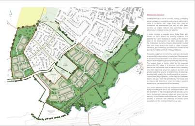
Introduction
This report presents a landscape sensitivity assessment of a number of sites considered
for development as part of the preparation of the Charnwood Local Plan 2021–2037. Its
purpose is to consider the landscape sensitivity of sites, and ways that significant adverse
impacts can be mitigated. The recommended mitigation measures have informed the Pre-
Submission Draft Charnwood Local Plan.
The report has been prepared by officers at Charnwood Borough Council and was
produced over the period 2019 to 2021.
The sites that have been considered in this report were submitted to the Council for
consideration for development as part of the regularly reviewed Strategic Housing and
Employment land Availability Assessment (SHELAA).
This assessment draws from other evidence that the Council has commissioned to inform
the initial site assessment work carried out as part of the Sustainability Appraisal of the
Local Plan:
Landscape Sensitivity Assessment of SHELAA Sites (2019) prepared by Land Use
Consultants (LUC):
www.charnwood.gov.uk/files/documents/landscape_sensitivity_assessment_of_shl
aa_sites_march_2019/Landscape%20Sensitivity%20Assessment%20of%20SHLAA
%20Sites%20%28March%202019%29.pdf
Landscape Capacity and Sensitivity Study Addendum (2021) prepared by LUC:
www.charnwood.gov.uk/files/documents/charnwood_landscape_capacity_and_sen
sitivity_assessment_addendum_2021/Charnwood%20Landscape%20Sensitivity202
1%20%281%29.pdf#Charnwood%20Landscape%20Capacity%20and%20Sensitivit
y%20Assessment%20Addendum%202021
Green Wedges, Urban Fringe, Green Infrastructure, Enhancement Zones and
Areas of Local Separation Methodology and Assessment Findings Report (2016)
prepared by Arup: www.charnwood.gov.uk/greenwedge_als
The assessment follows the principles in the National Planning Policy Framework (NPPF)
which states that significant adverse impacts on these objectives should be avoided and,
wherever possible, alternative options which reduce or eliminate such impacts should be
pursued.
The assessment for each site summarises the main landscape features, identifies those
aspects which are vulnerable to change as a result of housing development and
recommends mitigation measures. The recommendations for mitigation measures have
informed the preparation of the Pre-Submission Draft Charnwood Local Plan in terms of
site specific policies as well as informing the capacity and parts of the site that are capable
of development without giving rise to significant adverse impacts.
1
Sites Included for Assessment

The sites included in this assessment are those that have been assessed to have medium-
high landscape sensitivity by the Landscape Sensitivity Assessments undertaken by LUC
and those that fall within an Area of Local Separation or Green Wedge.

Not all sites falling into these categories are included in this assessment and this is either
because a site was discounted from further investigation due to other matters, the
assessments undertaken to inform the Draft Local Plan were sufficient, or because the
landscape mitigation measures were considered in the round with other issues through
technical exchanges with site promoters.

The sites assessed in this report are the following:

PSH027 Land at Bull in the Hollow, Loughborough,

PSH144 Land at Gynsills Lane, Anstey,

PSH189 Barkby Thorpe Lane, Thurmaston,

PSH261 Homefield Road, Sileby,

PSH467 Land off Watermead Lane. Loughborough,

PSH108 Quorn Lodge

PSH387 High Leys Manor Farm, Anstey

PSH389 Groby Road, Anstey,

PSH460 Land at Parkview Nursery, Anstey,

PSH463 Cliffe Road, Birstall,

PSH474 Cossington Road, Sileby,

PSH483 Land south of Ashby Road, Shepshed,

PSH495 Small Ingleberry Road, Shepshed

                                              2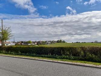
PSH027 and PSE451 - Bull in the Hollow Farm, Leicester Road, Loughborough

DESCRIPTION

PSH027 lies east of the A6, on the main approach into Loughborough. The landform
gently slopes toward the Soar River. The site is bounded on the north by Charnwood
Water Reservoir Lake and woodland, a locally designated wildlife priority habitat. The site
is scrubby to the west with a peri-urban /suburban feel, is more rural arable to centre and
east. The north-eastern wooded area is part of the Local Wildlife Site.

There is a definite sense of leaving the settlement moving southward along this stretch of
the A6 and more so moving east along the Public Right of Way (PROW) K32, towards the
Grand Union Canal at Woodthorpe Bridge. This PROW forms the southern edge of the
site.

Views to and from are filtered when moving east along PROW K32 and there is an
awareness of the proximity of new housing to the north east of Quorn and the north of
Barrow.

PSE451 is a very small field within PSH027, enclosed by tall hedgerows, comprising of
archery clubhouse and stores and immediate grassed area to the east which until recently
had been used as an archery target range, as stated above flanked to the south by the
PROW K32, to the east by an open expansive arable field. The farmstead itself abuts to
the southeast, fronting on to the A6. The site is introverted and contained, with views in
and out occluded, except for very brief glimpses along PROW K32.

DEVELOPMENT PROPOSAL

No development proposals submitted at time of writing.

LOCAL PLAN EVIDENCE FINDINGS

The Landscape Sensitivity Assessment of SHLAA Sites (March 2019) assessed the wider
area of land, PSH027, as part of a composite assessment with four other sites. It
evaluated the landscape sensitivity of PSH027, to 2-3 storey residential housing, to be
low-moderate sensitivity.

                                            3
The Charnwood Landscape Capacity and Sensitivity Assessment Addendum Report
(February 2021) assessed the site PSE451 as having low to moderate sensitivity, to
employment developments, noting there were no significant variations in landscape
sensitivity within the site.
Both sites lie within a proposed Area of Local Separation between Loughborough and
Quorn, previously designated as a Green Wedge in the Borough of Charnwood Local Plan
(2004) and identified for consideration for an Area of Local Separation in the Local Plan
Core Strategy (2015).
The proposed Area of Local Separation was evaluated in the Green Wedges, Urban
Green Infrastructure Enhancement Zones and Areas of Local Separation Report (March
2016). The Loughborough/Quorn Proposed Area of Local Separation is identified as
PALS-1 in the report, which scored the whole of PALS-1 area as ‘weak’ for its purpose.
The report states it “would provide a less critical gap between Loughborough and Quorn”
due to scale and lack of inter-visibility between settlements. While this is the case, the site
itself does have some inter-visibility of Quorn as evidenced by walking along the PROW
K32. PSH027 is to the north part of PALS-1 and for this area is says it has “limited visual
and functional connectivity with surrounding settlements and greater linkages with the
wider countryside”. It concludes it plays a “lesser role in preventing coalescence between
settlements”. At the time of the assessment there were no extension opportunities
identified.
KEY LANDSCAPE FEATURES
The key landscape features that would be sensitive to change:
the physical and perceptual separation between Loughborough and Quorn and
Barrow;
the rural setting the landscape provides to Loughborough;
the long distance views from the site across the Soar Valley; and
trees and hedgerow.
CONCLUSION
The site contributes to the separation between Loughborough and Quorn. The eastern
portion of the site contributes to the landscape setting of Loughborough, as seen from the
Woodthorpe Bridge and from glimpse views from the A6.
The development of the PSH027 would result in a moderate reduction in separation; and
this would not be significant to the function of the proposed Area of Local Separation,
providing mitigation through design ensures built form is not visible from A6.
PSE451 is of less significance for the purpose of the proposed Area of Local Separation.
Should this site be developed for housing, the following mitigation principles should be
followed:
4
retain and enhance existing hedgerow and groupings of trees;
avoid high ground which might otherwise result is prominent housing visible from A6
from where there is visibility of built from of Quorn;
make spatial allowance for high canopy tree species to break up built form to
maintain the sense of separation between Loughborough and Barrow; and
avoid elevated/sloping land where built form would be visually prominent within the
wider landscape.
5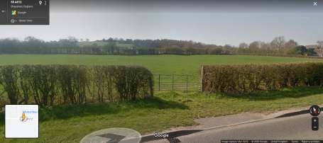
PSH108 Quorn Lodge, Loughborough

DESCRIPTION

The site is rural farmland characterised by wood pasture, an historic form of pasture, which
lies to the south-eastern edge of Loughborough. Wood pasture is a valuable part of the
UK’s natural and historic environment. Sheep currently graze. It presents as a rural
pastoral scene. The landform is relatively flat, with very minor gradients. The western
perimeter is generously screened by the A6 corridor wooded verge and the Great Central
Railway (GCR) embankment vegetation. The eastern perimeter is partially screened by
hedgerow.

This is a rich and well treed rural landscape which feels relatively cut off from the
settlement of Loughborough notwithstanding the proximity of new housing which lies to the
east of the GC railway.

This historic map illustrates pastoral tree distribution. When compared with present day
aerial photography we see how tree distribution has declined.

                                             6
DEVELOPMENT PROPOSAL
No development proposals submitted at time of writing.
LOCAL PLAN EVIDENCE FINDINGS
The Landscape Sensitivity Assessment of SHLAA Sites (March 2019) assessed PSH108
as part of a composite assessment with four other sites southeast of Loughborough. It
evaluated the landscape sensitivity, for 2-3 storey residential housing, to be low-moderate
sensitivity. In notes on variations in landscape sensitivity, it acknowledges that the site has
weaker association with Loughborough.
The site falls within a proposed Area of Local Separation between Loughborough and
Quorn, previously designated as a Green Wedge in the Borough of Charnwood Local Plan
(2004) and identified for consideration for an Area of Local Separation in the Local Plan
Core Strategy (2015).
The proposed Area of Local Separation was evaluated in the Green Wedges, Urban
Green Infrastructure Enhancement Zones and Areas of Local Separation Report (March
2016). The Loughborough/Quorn Proposed Area of Local Separation is identified as
PALS-1 in the report, which scored the whole of PALS-1 area as ‘weak’ for its purpose.
KEY LANDSCAPE FEATURES
The key landscape features that would be sensitive to change:
the sense of separation between Loughborough and neighbouring settlements;
the rural setting the landscape provides to existing settlement;
the setting that the landscape provides to heritage features including historic
farmhouses;
frequent trees and hedgerows including pastoral trees;
open pastoral character; and
tranquillity - aural and visual.
CONCLUSION
The site is less important as a separation area between Loughborough and Woodthorpe
because it lies to the northeast and Loughborough advances toward Woodthorpe from the
north and northwest. Both the GCR and the A6004 are strong linear barriers. The site has
much greater importance as physical and perceptual separation between Loughborough
and Quorn. This is because it is currently free of built form; it presents and appears as a
secluded wood pasture visible as a filtered view moving into Loughborough via the A6 with
more open views from the new housing to the northeast.
Development of the site would not influence separation between Loughborough and
Woodthorpe. It would though advance the settlement edge of Loughborough toward
Quorn. This would be both physical and perceptual.
7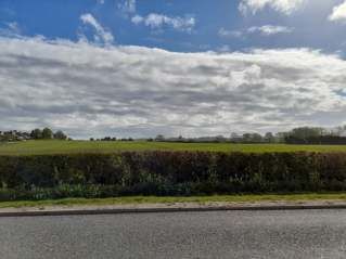
Physical separation: The land lies between Loughborough and Quorn and is strongly rural
in character. The southern tip of the site lies only 398m from the settlement edge of Quorn.

Perceptual separation: As one travels southward along the routes to the east and west of
the site there is a sense of having left Loughborough and of being in a rural area. On
travelling from the A6 or Quorn toward Loughborough there is a sense of being close to,
but on the outskirts of both settlements. There would be no direct inter-visibility from the
site of Loughborough and Quorn. However, there is visibility from the new housing at
Farley Way and from the site to the new housing which although physically separated by
the barrier of the railway is perceived as adjacent.

On the basis of development of 2 storey dwellings, development of any part of this site
would advance the settlement edge toward Quorn and would be visible from moving
vantages along the A6. This would result in Quorn and Loughborough being perceived as
merged.

Due to alteration or removal of the landscape characteristics of wood pasture and erosion
of settlement separation it is unlikely that any amount of new housing development could
be accommodated on the site without significant adverse landscape impacts.

Mitigation in terms of low single-story standard dwellings to the southern portion of the site
is unlikely to eliminate or reduce harm to the landscape character and settlement
separation.

                                              8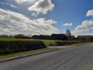
PSH389 Land off Groby Road (north and south)
DESCRIPTION
The site is comprised of two extensive areas of land north and south of Groby Road, to the
south-southwest of Anstey. The first south of Groby Road wraps around the cemetery.
The second is immediately north of Groby Road comprising two fields.
The sites are comprised of medium to large scale arable fields which form the upper valley
slopes of the Rothley Brook valley. It is a strongly rural landscape yet close to the
settlement. Historically many existing hedges were recorded in this area in the 1884
mapping and represent significant assets worthy of enhanced protection.
The arable fields are bounded by low maintained hedgerow with occasional trees. . The
landform rises northward from the brook, with the land to the north of Groby Road being
more prominent. . The southern portion provides a sense of separation for Anstey and
Groby and Leicester. Views, from the north of Groby Road portion and upper southern
portions, are extensive to the south toward Glenfrith beyond the A46 corridor and west
toward Groby. Skyline intrusions include pylons supporting major High Voltage powerlines
following the course of the brook to the south of the southern portion and two wind turbines
to the west of the northern portion. Public Right of Way (PROW) J70 traverses the
southern portion in a NW to SE axis and PROW J72 bisects the northern portion in a
broadly W to E axis.
Experientially the aural tranquillity is impacted by A46 noise and visual tranquillity by
pylons. The perception is of an open rural expansive landscape with a sense of being able
to get out of the settlement and experience rural qualities to a moderate degree.
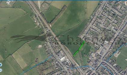
9DEVELOPMENT PROPOSAL
The site promoters submitted promotion material including a landscape appraisal by Golby
and Luck and a masterplan for the sites north and south of Groby Road in December
2019.
The broad outline was for housing with green infrastructure across both sites with green
infrastructure mainly to the outer edge of the site, west of the north of Groby Road site and
south of the south of Groby Road site.
This was revised by a fresh submission in November 2020 giving a more detailed
illustration of possible housing numbers and this iteration included part of PSH 388 (see
next section).
10LOCAL PLAN EVIDENCE FINDINGS
The Landscape Sensitivity Assessment of SHLAA Sites (March 2019) assessed a broad
area of land which included PSH389. It evaluated the landscape sensitivity to 2-3 storey
residential housing to be moderate sensitivity. .
The southern site, south of Groby Road is located within the Leicester (Beaumont
Leys)/Birstall/Thurcaston/ Anstey/Cropston Green Wedge designated in the Borough of
Charnwood Local Plan (2004) and retained in the Local Plan Core Strategy (2015).
A review of Green Wedges was reported in the Green Wedges, Urban Fringe Green
Infrastructure Enhancement Zones and Areas of Local Separation Report (March 2016).
The site falls within GW-1 and reflects the defined characteristics and function of a Green
Wedge. There are no zones of weakness identified within the site and it functions strongly
for a recreational resource.
The northern site assessed is identified in the report as part of an Urban Fringe Green
Infrastructure Enhancement Zone (GIEZ-3). The report finds GIEZ-3 scores moderate for
purpose, and recommends improving pedestrian links between Anstey, Cropston,
Thurcaston and the wider environmental assets of Bradgate Country Park and the
Charnwood Regional Forest. It also recommends diversification of land use immediately
adjacent to settlements to enhance the provision of accessible open space.
KEY LANDSCAPE FEATURES
The key landscape features that would be sensitive to change:
rising prominent landform;
strong rural character;
hedgerow and trees; and
separation of settlements.
CONCLUSION
The southern site actively aids in preventing the coalescence of Anstey with Leicester and
Anstey with Groby. It meets the wider purpose of the Green Wedge to a strong extent. It
provides a green lung for Anstey in that area and is publicly accessible by a network of
PROW which strongly connects it to Groby. It links directly to the Rothley Valley and to
PROW J71 which links south Anstey to Leicester. The site provides informal recreation
opportunities and is adjacent to a cemetery for quiet contemplation. It is a significant and
integral part of the Green Wedge.
The northern site also has some value in providing separation between Groby and Anstey.
Development of this site would advance the settlement edge of Anstey closer to Groby.
Built form would overlook the southern site and impact on views beyond the Green
Wedge. It is traversed by PROW J70 and J72. The north of Groby Road site would be
more visually screened and easier to mitigate for developing due to intervening hedgerow.
11Development would be visually prominent and would erode the sense of separation for the
south of Groby Road site.
The sites are bounded by defensible and readily recognisable boundary features. If
developed, the resultant boundary changes for PSH389 would affect the extent to which
the Green Wedge meets its purpose in that Anstey would be seen to advance towards
Leicester and to a lesser extent toward Groby. The land south of Groby Road functions
clearly as a physical and perceptual gap. Reduction in the width of this gap would erode its
integrity as it would be clearly visible from Glenfrith housing and associated open spaces.
Development would be visually prominent and would erode sense of separation.
Mitigation of development should incorporate:
retention of hedgerows especially hedgerow trees;
enhancing the tree planting with high canopy species to be managed to attain
unrestricted high canopy - this would help break up built from and provide
intervening vegetated backdrop;
extending existing recreational routes to create an integrated Green Infrastructure
network facilitating linkages between settlements, along brooks and recreational
destinations e.g. Bradgate Park; and
enhancing the functions of Green Wedge for settlement separation, distinctive
identity and landscape setting;
12PSH387 & Part of PSH388 High Leys Farm/Manor Farm
DESCRIPTION
The site is comprised of two areas of land northwest of Anstey. The first PSH387 is a
single field to the west of Green Farm Court (PSH387) and the second includes the four
fields that extends from it northwest up to the access drive off Bradgate Road for Anstey
High Leys Farm (the southern part of PSH388).
The sites are comprised of medium pasture to large scale arable fields. It is a strongly rural
landscape yet close to the settlement. Historically many existing hedges were recorded in
this area in the 1884 mapping and represent significant assets worthy of enhanced
protection.
The field boundaries of PSH387 are very well treed. The landform rises northward with
fields adjacent to the access for High Leys Farm sits on the brow of the hill and is
prominent. Skyline intrusions across the site are high voltage overhead power lines and
include two wind turbines to the west. Public Right of Way (PROW) J72 bisects in a
broadly W to E axis.
Experientially visual tranquillity is impacted by the wind turbines. .
West Anstey in Leicester 1884-1886 mapping
13DEVELOPMENT PROPOSAL
The site promoters submitted promotion material including a masterplan in November
2020 setting out a joint concept incorporating the preceding section site PSH389 with
these sites giving a more detailed illustration of possible housing numbers in this
assessment.
LOCAL PLAN EVIDENCE FINDINGS
The Landscape Sensitivity Assessment of SHLAA Sites (March 2019) assessed a broad
area of land which included PSH387 and PSH388. It evaluated the landscape sensitivity to
2-3 storey residential housing to be moderate sensitivity. It noted that higher ground of
PSH388 to have sensitivity of moderate to high and that development for that portion
would “be out of keeping with the existing settlement of Anstey and would be visually
prominent in the wider landscape and visible in skylines”.
The Charnwood Landscape Capacity and Sensitivity Assessment Addendum Report
(February 2021) assessed the whole of PSH388. It identified an overall medium sensitivity
for 2-3 storey housing. However, for form, density and identity and setting of existing
settlements, the report highlighted the site had medium high sensitivities to this criterion.
A review of Green Wedges was reported in the Green Wedges, Urban Fringe Green
Infrastructure Enhancement Zones and Areas of Local Separation Report (March 2016).
The northern portion of PSH388abuts the southern edge of the Newtown Linford/Anstey
Area of Local Separation designated in the Borough of Charnwood Local Plan (2004) and
retained in the Local Plan Core Strategy (2015).
The Newtown Linford/Anstey Area of Local Separation is identified as ALS-M in the Green
Wedges, Urban Green Infrastructure Enhancement Zones and Areas of Local Separation
Report (March 2016). The ALS-M has a purpose score of ‘moderate’ and there are no
zones of weakness identified. ALS-M plays an important role in maintaining separation
between Newtown Linford and Anstey.
PSH387 and the part of PSH388 assessed are identified in the report as part of an Urban
Fringe Green Infrastructure Enhancement Zone (GIEZ-3). The report finds GIEZ-3 scores
moderate for purpose, and recommends improving pedestrian links between Anstey,
Cropston, Thurcaston and the wider environmental assets of Bradgate Country Park and
the Charnwood Regional Forest. It also recommends diversification of land use
immediately adjacent to settlements to enhance the provision of accessible open space.
KEY LANDSCAPE FEATURES
The key landscape features that would be sensitive to change:
rising prominent landform;
strong rural character;
hedgerow and trees, some of which may be veterans; and
14 separation of settlements.
CONCLUSION
The southern portion of PSH388 would not extend Anstey northward but would create a
stronger linear edge in a NE to SW axis with the access road to Anstey High Leys and
extend the north-western Anstey settlement edge westward. This would be noticeable from
Bradgate Park and for glimpsed views from Bradgate Road. The brook which traverses to
the south of the site, in a NW to SE axis provides opportunities for green infrastructure
network development and potential link to the PROW J72 which lies to the south.
Site PSH 387 being more visually screened possesses good scope for on-site mitigation
along all boundaries such that any development here could be easily accommodated and
contained. Retention of field trees would be important as part of the landscape mitigation.
The PROW J72 is close to the eastern boundary and brook to the western boundary
provide opportunities for green infrastructure network development which could help
integrate with any potential development of the southern portion of PSH388.
The sites are bounded by defensible and readily recognisable boundary features. If
developed, development may be visually prominent for PSH388 and would erode the
perceptual sense of separation between Anstey and Newtown Linford.
Mitigation of development should incorporate:
retention of hedgerows especially hedgerow trees;
enhancing the tree planting especially with high canopy species to be managed to
attain unrestricted high canopy - this would help break up built from and provide
intervening vegetated backdrop;
extending recreational off existing routes to create an integrated Green
Infrastructure network facilitating linkages between settlements, along brooks and
recreational destinations e.g. Bradgate Park;
enhancing the functions of Green Wedge for settlement separation, distinctive
identity and landscape setting; and
careful siting of new built form to minimise the impact on separation of Newtown
Linford and on views from the north
15PSH460 Park View Nursery Site off Gynsill Lane, Glenfield
DESCRIPTION
The site, a slightly domed brownfield former nursery, lies to the rear of existing houses on
Gynsill Lane and is located within Anstey Parish although is closer to Glenfield, Leicester.
There is no direct sense of it being part of Anstey and it is more likely to have stronger
visual association with Leicester. The land to the west, in Blaby District, has recently been
developed. It is accessed from Gynsill Lane via a private track.
The site, a small grass field including a pond, is enclosed by mature hedgerow of high
canopy trees and has an intimate characteristic. The land to the north east is woodland.
Visually the site is contained with no direct visibility from the southern edge of the
settlement of Anstey to the north of A46. Nor is there visibility from Gynsill Lane. The site
is experienced as secluded and set apart. A Public Right of Way (PROW) J70 runs along
to the east of the site beyond the adjacent wooded land. The PROW terminates SE of the
site within a hedgerow at the boundary to Leicester City. Beyond which lies vestigial parts
of the Leicester Frith farmland and modern housing. To the north it links across Gynsill
Lane towards Groby and Anstey.
Historic Leicester 1903-1904 mapping indicating the land was either woodland or orchard.
16DEVELOPMENT PROPOSALS
No development proposals submitted at time of writing.
LOCAL PLAN EVIDENCE FINDINGS
The Charnwood Landscape Capacity and Sensitivity Assessment Addendum Report
(February 2021) assessed this site as having low sensitivity, noting there were no
significant variations in landscape sensitivity within the site.
It did not reference the Green Wedge function of the site; though it recommended under
‘Opportunities for mitigation or landscape enhancement’ that future development should
amongst other things “retain the sense of separation between settlements to protect their
distinct identities.”
It noted mature hedgerow boundaries surrounding the sites and the deciduous woodland
adjacent to the west as key landscape sensitivities which contribute to the natural
character of the landscape and enhance the local landscape structure.
The site is located within the Beaumont Leys/Glenfrith/Anstey/Groby Green Wedge
designated in the Borough of Charnwood Local Plan (2004) and retained in the Local Plan
Core Strategy (2015).
A review of Green Wedges was undertaken in the Green Wedges, Urban Fringe Green
Infrastructure Enhancement Zones and Areas of Local Separation Report (March 2016).
The site is within the area identified as GW-1A in the report, forming its SW tip, on the
boundary with Blaby District. The report recommended the designation GW-1 be largely
retained, including the land covered by this site.
KEY LANDSCAPE FEATURES
The key landscape features that would be sensitive to change:
mature hedgerow boundaries;
deciduous woodland adjacent to the west; and
role in supporting the functions of the Green Wedge.
CONCLUSION
The site does not perform as a significant part of the Green Wedge and does not make
any significant contribution to the sense of separation from Leicester to the south and
Anstey to the north. The site is secluded in nature and has new housing immediately to
the west and existing housing on Gynsill Lane to the north.
Should this site be developed for housing, the following mitigation principles should be
followed:
17 preserving and enhancing the existing pond area; and
preserving the hedgerow within a wider buffer corridor, which will aid provision of
wildlife movement and, if developed as a green route, could aide connection to
PROW J70 and thereby to the landscape beyond.
18PSH463 Land off Cliffe Road (South of Greengate Road), Birstall
DESCRIPTION
The landscape is gently rolling with the southern field dipping toward the Great Central
Railway and very gentle gradient from bisecting hedgerow to northern tip. It is in
agricultural arable land-use. The site is secluded by being enclosed by relatively tall well-
developed hedgerow and is bisected east to west into two by another hedgerow. There is
a small copse of mature trees within the upper portion.
The site is only directly accessible by a field gate off Greengate Lane. There are two other
potential points of access though from Henson road and Cliffe Road, albeit this is heavily
vegetated for an informal pedestrian access.
The site is bounded to the east by substantial hedgerow along the length of the Great
Central Railway which forms a definitive barrier from Birstall settlement. A Public Right of
Way (PROW) access over the railway via a footbridge slices through the lower wider
portion from east to west, other routes are beaten informal tracks along the hedgerows.
The southwestern portion affords views of Birstall to south and east and to industrial zones
of Leicester to the west and some to the uplands beyond.
Perceptually, it feels secluded due to its enclosed rural characteristics.
19PROW access is via a footbridge. It is accessible informally via a field gate off Greengate
Lane and Henson Road and potentially could be from Cliffe Road.
DEVELOPMENT PROPOSALS
No development proposals submitted at time of writing.
LOCAL PLAN EVIDENCE FINDINGS
The Charnwood Landscape Capacity and Sensitivity Assessment Addendum Report
(February 2021) assessed the site as having overall low sensitivity, noting there were no
significant variations in landscape sensitivity within the site.
However, it noted key landscape sensitivities as:
Mature hedgerows and in-field trees, which contribute to the natural character of the
landscape.
The proximity to the Great Central Railway Site of Nature Conservation Interest
containing mature deciduous woodland.
The recreational value of the public footpath crossing the site.
It did not reference the Green Wedge function of the site though it did note that “the area
plays some part in the sense of separation between the settlement edge of Birstall and the
business park (within Leicester City) to the west”.
The site is located within the Leicester (Beaumont Leys)/Birstall/Thurcaston/
Anstey/Cropston Green Wedge designated in the Borough of Charnwood Local Plan
(2004) and retained in the Local Plan Core Strategy (2015).
A review of Green Wedges was reported in the Green Wedges, Urban Fringe Green
Infrastructure Enhancement Zones and Areas of Local Separation Report (March 2016).
The report identified the site as GW-1 (C) and stated in their report that it performed “less
strongly against the Green Wedge purpose”. The report caveated their conclusion by
20saying it “should be retained pending further work by Leicester city council, recognising the
importance of this area as part of a cross-boundary strategic designation”.
KEY LANDSCAPE FEATURES
The key landscape features that would be sensitive to change:
the physical and perceptual separation between Birstall and Leicester City;
mature hedgerows and in-field trees; and
the proximity to the Great Central Railway Site of Nature Conservation Interest
containing mature deciduous woodland.
CONCLUSION
The two fields contribute to the sense of settlement separation between Birstall and
Leicester.
A limited area could be developed in the south eastern corner where topography would
reduce the impact of development on settlement identity.
Should development take place on this site and its surroundings it will be essential to plan
green infrastructure in a coordinated manner with developments in Leicester City.
Mitigation measures for this site should include:
preserving the hedgerow and TPO zones within a wider buffer corridor to aid
provision of wildlife movement and, if developed as a green route, this could aide
connection to existing PROW and thereby to the landscape beyond;
preserving and enhancing the Great Central Railway woodland corridor; and
preserving and enhancing the recreational value of the public footpath crossing the
site.
It will be important to work closely with Leicester City as they progress their local plan to
understand how the effects settlement identify and other functions of Green Wedge can be
satisfactorily mitigated.
21PSH474 Land off Cossington Road, Sileby
DESCRIPTION
The site occupies the land between Sileby and Cossington, to the east of the Cossington
road, adjacent to Brook Farm. It is typical for the character area of the Soar floodplain, a
large open field gently rising toward the east. As viewed and experienced from Sileby the
site is seen and experienced as rural and in agricultural use.
While the Midland Mainline railway embankment presents a physical barrier on the east,
the landscape visually connects north-eastward beyond. The field is in arable cultivation
and is mostly bounded by hedgerows; generally low and regularly managed. The southern
edge to the field forms a boundary with Brook Farm farmstead and Derrys Nurseries. This
is dominated by conifer trees which densely screen views of the nurseries as well as of
Cossington to the south. The associated brook flows from the southeast corner along the
irregular boundary then cuts in through Derrys Nurseries.
The Brook Farm Farmstead and tree cover effectively screens off views of Cossington for
various points along Cossington Road and as seen through the hedge line at Molyneux
Drive, Sileby. The fields to the west of the road confirm the rural characteristic of the
scene. The spatial quality from the edge of Cossington to the nursery is confined and
enclosed with little sense
of another settlement
beyond.
Exposed rural:urban
interface –
northernboundary of site
abutting Sileby
22View across site to the east
showing landform. To right of
frame the railway
embankment is visible as well
as tree cover of the
landscape beyond.
View across site toward
Brook Farm and the northern
flank of Derrys Nurseries. To
left of frame glimpsed
through the trees rising
landform of the landscape
beyond can be seen.
The site has a strong open connection with Sileby which presents a hard urban edge to its
northern boundary characterised by a random mix of irregular sequences of low clipped
hedges and close boarded fencing of varying height and occasional trees predominate to
the east. Sileby, itself has sprawled from its historic core to the northeast, east and west
along its B roads while the more compact settlement of Cossington has grown from its
historic core slightly to the east and north. The Grade II listed Brook Farm building
historically had a closer physical association to Cossington and the brook.
There are no direct views of the site or of Sileby from the edge of Cossington at the
Cossington road sign position. Here the spatial quality is confined and enclosed with little
sense of another settlement beyond. The land to the east of the road is used as a plant
nursery with an ancillary timber yard conveying a peri-urban characteristic. Views of Sileby
23and the western edge of the site only become apparent when approaching the entry sign
for Sileby at the boundary of village, between the nursery and Brook Farm.
Glimpsed views of the site can be seen from the Public Right of Way (PROW) through the
fields on the west of the road toward the site. There are extensive views across the fields
toward the rocky uplands of the Charnwood Forest. Views of the site are filtered between
the trees. The experience is that of being within a rural countryside setting on the outskirts
of the village though there is a strong visual connection with Sileby.
There are currently no public or permissive rights of way, though there is a farm track from
the field gate across the site to the east.
Its open expansive character gives a moderate feeling of being in the countryside albeit
close to two settlements.
DEVELOPMENT PROPOSAL
There is currently an outline planning application P/21/0491/2 Land east of Cossington
Road, Sileby for up to 170 dwellings with all matters reserved other than access together
with associated landscaping and other infrastructure.
The applicant provided the following documents in support of the application:
Illustrative Masterplan, Golby & Luck, February 2021
Landscape and Visual Impact Assessment, Golby & Luck, February 2021
Arboricultural Assessment, FPCR, February 2021
While this is an outline application with layout and landscape reserved, the indicative
masterplan gives a worked example of how the developer envisages delivering
development. In this worked example the proposal essentially sets out to provide built
form to the northern sector and a series of compartmentalised open spaces to the
southern sector as a mitigation measure.
LOCAL PLAN EVIDENCE FINDINGS
The Charnwood Landscape Capacity and Sensitivity Assessment Addendum Report
(February 2021) assessed this site as having low to moderate sensitivity for 2-3 storey
24residential housing development, noting there were no significant variations in landscape
sensitivity within the site.
The site forms part of the Area of Local Separation between Sileby and Cossington
designated in the Borough of Charnwood Local Plan (2004) and retained in the Local Plan
Core Strategy (2015).
The landscape sensitivity assessment identifies the role of the site in separation as
significant; evaluating this under the criteria for form, density, identity and setting of
existing settlement/ development; but this assessment was not intended to provide a full
assessment of the Area of Local Separation.
The separation role was, however, evaluated in the Green Wedges, Urban Green
Infrastructure Enhancement Zones and Areas of Local Separation Report (March 2016).
The Sileby/Cossington Area of Local Separation is identified as ALS-D in the report. ALS-
D has a purpose score of ‘moderate’ in the report, which sets out that it provides the gap
between Sileby and Cossington, preventing further ribbon development along Cossington
Road and ensuring that the integrity of the gap is maintained.
KEY LANDSCAPE FEATURES
The key landscape features that would be sensitive to change:
the sense of separation between Sileby and Cossington settlements;
the rural setting the landscape provides to the existing settlement; and
the setting of the grade II farmstead heritage.
CONCLUSION
The settlement edges of Sileby and Cossington are physically very close, yet there
remains a clear sense of separation provided by the Area of Local Separation. The site is
the entire eastern portion of the Area of Local Separation.
The landform of the site as it rises to the east makes it prominent and particularly sensitive
to change. The site is the last significant area of open rural landscape between the two
settlements of Sileby and Cossington.
Development of this site would have a substantial and critical effect on the purpose of the
Area of Local Separation. Development of the site would irrevocably alter the larger more
significant eastern part of Area of Local Separation, changing the land use nature and
characteristic from open rural agriculture to urban housing and urban green space. The
erosion of the Area of Local Separation cannot be mitigated satisfactorily.
25PSH483 Land South of Ashby Road, Shepshed
DESCRIPTION
The site is a rectilinear peri-urban field extending southward off Ashby Road on the
southern edge of Shepshed. The ground rises up toward the southern hedgerow. Morley
Hill and Quarry Reserve, a Regionally Important Geological Site, forms a prominent low
backdrop to the south. The field is bounded by hedgerows with sparse tree cover mainly to
the south and southwest. The site is of little historic significance and has always been part
of the local field system. There are no special features of note.
DEVELOPMENT PROPOSALS
No development proposals submitted at time of writing.
LOCAL PLAN EVIDENCE FINDINGS
The Landscape Sensitivity Assessment of SHLAA Sites (March 2019) assessed a site
PSH436, which PSH483 falls within, as part of a wider composite assessment of 13 sites,
all bar one of which lie to the south of Ashby Road. It evaluated the landscape sensitivity
to 2-3 storey residential housing to be low-moderate sensitivity. It noted no variation on
sensitivity for PSH436 but noted an increased sensitivity for PSH322 which lies south
26southwest of PSH436 and PSH405 which lies south southeast of the site, both due to their
rising slopes and more visually prominent landform.
The Charnwood Landscape Capacity and Sensitivity Assessment Addendum Report
(February 2021) assessed the site, PHS483 on its own. It confirmed it as having low-
moderate sensitivity for 2-3 storey housing, noting there were no significant variations in
landscape sensitivity within the site.
KEY LANDSCAPE FEATURES
The key landscape features that would be sensitive to change:
views south toward hills and woodland of the Charnwood Forest;
rising landform; and
hedgerows.
CONCLUSION
Development mitigation would require retention of hedgerows with enhancement plus the
provision for high canopy strategic tree planting to break up built form for distant views.
Any development should also open up and frame distant views to the hill and woodlands
which are strong attributes of the Charnwood Forest.
Development should be low density with generous wood pasture parkland to reflect being
in the Charnwood Forest.
27PSH495 Ingleberry Road, Shepshed
DESCRIPTION
This is a rectangular rural agricultural field to the south of Shepshed bounded on the north
by Iveshead Lane sharing a boundary with similar fields to the west and east. To the north
northwest lies Morley Quarry reserve. It has an undulating rising landform toward Ives
Head Hill to the south.
DEVELOPMENT PROPOSAL
No development proposals submitted at time of writing.
LOCAL PLAN EVIDENCE FINDINGS
The Charnwood Landscape Capacity and Sensitivity Assessment Addendum Report
(February 2021) assessed this site. It assessed the landscape sensitivity for 2-3 storey
housing to be moderate-high, noting there were no significant variations in landscape
sensitivity within the site.
The assessment concluded that “development of the sloping site has potential to be
visually prominent and distract from the wider views of Ives Head Hill”.
28KEY LANDSCAPE FEATURES
The key landscape features that would be sensitive to change:
views and visual character especially of Iveshead Hill and northward of the Trent
Valley;
the rural agricultural characteristic, its intactness and separation from Shepshed;
the sloping landform and its connection to the Charnwood Forest;
low hedgerows and occasional trees; and
characteristic and experiential quality of Iveshead Lane.
CONCLUSION
Development of this site would not be possible to mitigate due to the disconnection from
the settlement and its rising prominent landform.
Any development would require access off Iveshead Lane, a rural lane. This would have
adverse effect on its rural character and require loss or erosion of hedgerows.
29PSH144 Gynsill Lane Capacity
DESCRIPTION
The site lies between Gynsill lane, Anstey Lane (A5630) and substantial hedgerow lines
which form the administrative boundaries of Blaby District to south west and Leicester city
to the south.
In terms of national landscape character it is part of the Trent Washlands, while regionally,
it is part of the Charnwood Forest. The local character is sloping undulating agricultural
field system with mature hedgerow. A Public Right of Way (PROW) J70 runs along the
western boundary then veers South East terminating at the edge of the open space north
of Glenfrith housing areas. This PROW provides active links out from Leicester city toward
Groby, Anstey and Bradgate Park.
Existing land use is agricultural with northern and western fields forming a secluded
pastoral landscape undulating varied gradient and small scale to the north, given over to
cattle or sheep grazing. The larger scale fields to the south are used for arable crops. The
land is better draining and rises from the hedgerow at southern end of the Park Pale
toward Leicester. It feels remote from Gynsill Lane and more so from Anstey with closer
association to the edge of Leicester.
The main vegetation consisting of mature trees is found mainly along the boundary
hedgerows for each field and some isolated and scattered groups of trees.
The site used to include a nationally registered ancient oak ATI Id #2574 of national
significance having a recorded girth of 9m, arguably the most significant tree within the
Borough of Charnwood; and several veteran ash trees but these have been lost due to
injudicious tree felling. The site includes an historic park pale of local significance.
Historically, the small fields to the north were wooded pasture in character while the larger
southern fields were enclosed by tall mature hedgerow well-endowed with high canopy
trees.
30Mapping Leicester 1884-1886
DEVELOPMENT PROPOSALS
A concept masterplan for the site for the land south of Gynsill Lane, West of Anstey Lane
and Anstey Pastures, Leicester was prepared in November 2020. The proposals seek to
yield a miniaturised concept of green infrastructure ‘wedges’ or corridors based on existing
hedgerows and other key landscape features between neighbourhood character zones of
housing. However this would both physically and perceptually diminish the current
separation between settlements and erode the Green Wedge function. The scale
reference for these micro ‘Green Wedges’ is not appropriate for the intention of the Green
Wedge.
LOCAL PLAN EVIDENCE FINDINGS
The Charnwood Landscape Sensitivity of SHLAA Sites Report (March 2019) assessed the
site as having medium overall sensitivity. The assessment notes that
“The site makes a strong contribution to the sense of separation between the suburbs of
Leicester to the south and Anstey to the north. And notes the site fall within a Green
Wedge”
The site is located within the Leicester (Beaumont Leys)/Birstall/Thurcaston/
Anstey/Cropston Green Wedge designated in the Borough of Charnwood Local Plan
(2004) and retained in the Local Plan Core Strategy (2015).
A review of Green Wedges was reported in the Green Wedges, Urban Fringe Green
Infrastructure Enhancement Zones and Areas of Local Separation Report (March 2016).
The site is identified as GW-1 in the report and recommended the designation be largely
retained. However it recommended that Zones of Weakness GW-1(A) to the south and
east of A46 be considered for removal. The review identified that that the Green Wedge as
a whole (which also extends to Thurcaston and Cropston) performed moderately against
three purposes of Green Wedge and performed strongly as for the purpose of providing a
recreational resource.
31KEY LANDSCAPE FEATURES
The key landscape features that would be sensitive to change:
the physical and perceptual separation between Anstey and Leicester City;
relationship of urban edge to surrounding countryside;
Public Rights of Way through the site to wider area;
mature hedgerows, copses and in-field trees; and
Park Pale
CONCLUSION
The site has been found to perform moderately in preventing the merging of settlements;
however separation is not visually perceptible from either side the A46. In contrast, the
visual connection is demonstrably strong between the site and Groby Lane and vice versa.
The site does perform as a significant part of the Green Wedge and makes a significant
contribution to the sense of separation from Leicester to the south and Anstey to the north.
Development of the site poses very significant challenges in terms of safeguarding the
functions of Green Wedge however should the site be developed, the following mitigation
measures should be considered:
preserving the existing vegetation principally the hedgerows, copses scattered and
isolated trees, particularly on north facing slopes;
providing of wide green corridors including the enhancement of PROW to form a
green corridor extending south to Glenfield and to the Glenfrith green space north of
existing housing;
retaining the northern pastures as wood pasture and locate development south of
and lower than the principal ridge; retaining and protecting the stumps of the lost
ancient and veteran trees in situ. retain and preserve the park pale and its
grassland setting; and
providing of high canopy tree planting both to the northern edge and to break up
built form.
32PSH189 Land off Barkby Thorpe Lane
DESCRIPTION
The site consists of 4 arable fields and three smaller pasture fields to the north, all
bounded to the east by the Midland Mainline railway to the north by Barkby land, the west
by large supermarket and housing and the south by a trailer home site, Inglenook Park
and Barkby Thorpe Lane.
The fields are in arable cultivation and mainly enclosed by low hedging, post and wire or
fencing. The landform has a gentle slope toward the railway. Trees are sparse in the
hedgerow, though a row of trees bisects the site in an east west axis and from a small
triangular copse in them western midsection. There is a copse on the northern field.
Views into the site are glimpsed through the southern hedge and from Barkby Lane from
the bridges both to the north and south east. The hedgerow along Barkby Lane is quite tall
and dense for about half its length, after this there are good expansive views across the
site. The trees give it a wooded quality to the site which aid in screening.
Glimpsed view across trailer home to the site beyond
33View across trailer home from Barkby Thorpe Lane
View east ward along Barkby Thorpe lane
34DEVELOPMENT PROPOSAL
There is an outline proposal for two small development schemes one to the north west
corner incorporating the two pasture fields and the copse and the other in the south
eastern corner adjacent to the trailer home park.
These indicative outline schemes will in both cases be highly visible and close off the view
of the residual fields of the site. There is however a proposed new link road associated
with the Northeast Leicester Sustainable Urban Extension which will more significantly
impact the area and form a visual and physical barrier.
LOCAL PLAN EVIDENCE FINDINGS
The Landscape Sensitivity Assessment of SHLAA Sites (March 2019) assessed a broad
area of land which included PSH189 northeast of the caravan site as part of a composite
assessment with two other sites. It evaluated the landscape sensitivity to 2-3 storey
residential housing to be moderate sensitivity. It noted no significant variation in sensitivity
across the sites.
The Charnwood Landscape Capacity and Sensitivity Assessment Addendum Report
(February 2021) focused on and assessed the site, PHS189 on its own. It confirmed it as
having moderate sensitivity for 2-3 storey housing, noting there were no significant
variations in landscape sensitivity within the site.
The site was located within the Syston/Thurmaston (east of Melton Road) Green Wedge)
designated in the Borough of Charnwood Local Plan (2004) but not carried forward by the
35Charnwood Local Plan Core Strategy (2015). The Core Strategy stated that areas
previously identified as Green Wedge would be considered as Areas of Local Separation.
A review of Green Wedges was reported in the Green Wedges, Urban Fringe Green
Infrastructure Enhancement Zones and Areas of Local Separation Report (March 2016).
The area is identified as ALS-L and the boundary review recommendation “is that the area
of land to the west of ALS-L and north of Barkby Lane (currently part of GW-3) should be
included within ALS-L” because it is currently “not performing the strategic role of a Green
Wedge, the southern boundary of this area would follow Barkby Lane”. The area covered
by PSH189 would be fall within the area recommended to be within the new Area of Local
Separation.
KEY LANDSCAPE FEATURES
The key landscape features that would be sensitive to change:
settlement separation;
trees and copse; and
views to the east.
CONCLUSION
The impact of the new link road and proposed residential development associated with the
North of Leicester Sustainable Urban Extension, which is subject to outline planning
application, would be to lessen its rural characteristic and obscure the expansive view to
the east. Development would be prominent. The site currently separates Syston from
Thurmaston. This separation will be further defined by the proposed new link road. It does
not appear to play an important role in separation of Thurmaston from Barkby due largely
to the intervening presence of a housing cluster to the east.
The site will largely be dominated by the link road which will take the majority of land and it
would require a degree of mitigation in terms of woodland planting to either side. This will
provide a definitive physical barrier.
Should this site be developed for housing, the following mitigation principles should be
followed:
woodland planting either side of the proposed link road;
housing developments to the north and south of the link road ought to response
positively to their respective settlements identity while enhancing design standards;
trees western edge of the site along the west of the Midland Mainline railway,
should be enhanced, providing linear green corridors as public / permissive rights of
ways;
the copse to the north and the east and west treed axis should be retained and
enhanced; and
provision for amenity green space with high canopy tree planting.
36PSH261 Homefield Road, Sileby
DESCRIPTION
The site is pasture used currently to graze sheep, and is comprised of several fields
bounded by hedgerows, plus a central one of which is under Tree Preservation Order. The
landform is that of a shallow dome with gradient rising from entrance off Homefield Road
then falling more steeply from the centre hedgerow toward the Midland Mainline railway to
the west, more steeply to the north and less steeply to the south. The western boundary
abuts with the cutting for the railway line which provides a substantial physical barrier.
There is a Public Right of Way to the lower southern corner linking it to the town centre. In
terms of landscape character, it is an example of upper gravel slopes of the Soar Valley.
This prominent dome of land provides extensive long distance views for the central,
eastern and northern portions out to ward the north. It is largely visually contained to the
west by hedgerow, while to the south and east they are contained by existing built form.
There are long distance views to the south and southwest over the settlement. There are
localised views in and out of the site from Homefield road and from Highbridge. Key
features of the skyline include the church tower. There are some filtered views from Slash
Lane and Mountsorrel Lane and the Soar river walkway. Views from Barrow Road are
obscured by the railway embankment and dense vegetation. Similarly views from Melton
Road are largely obscured by vegetation and landform.
37Views across site toward the Charnwood Forest upland from field entrance off Homefield
road
Historically it was used as pasture and wood pasture. Historic mapping for Leicester 1884-
1886 shows surveyed trees present for the eastern position.
38DEVELOPMENT PROPOSALS
A planning application P/21/0535/2 for a residential development comprising the erection
of 55 dwellings with associated infrastructure, access, landscaping and public open space
has been received in March 2021.
LOCAL PLAN EVIDENCE FINDINGS
The Landscape Sensitivity Assessment of SHLAA Sites March 2019 produced by LUC
assessed a broad area of land which included PSH261 west of the settlement as part of a
composite assessment with four other sites. It evaluated the landscape sensitivity to 2-3
storey residential housing to be low-moderate sensitivity. It noted no significant variation in
sensitivity across the sites.
The site is south of the Sileby/Barrow upon Soar Area of Local Separation designated in
the Borough of Charnwood Local Plan (2004) and retained in the Local Plan Core Strategy
(2015). A review of Areas of Local Separation was reported in the Green Wedges, Urban
Fringe Green Infrastructure Enhancement Zones and Areas of Local Separation Report
(March 2016). The report identified the Area of Local Separation as ALS-E and scored it
as moderate for purpose of maintaining separation between Sileby and Barrow. No zone
of weakness was identified. The site is partially in an area considered to be an extension
opportunity area by the report. The report in its boundary review identified an opportunity
for an extension of ALS-E to the south and east to ensure wider integrity of the gap is
maintained.
KEY LANDSCAPE FEATURES
The key landscape features that would be sensitive to change:
settlement separation between Sileby and Barrow upon Soar;
domed and sloping landform;
hedgerow;
TPO hedgerow trees; and
open vistas- long distance views.
Setting to Sileby Conservation Area
Area of Local Separation
CONCLUSION
In terms of the function of the site as Area of Local Separation, it is not important
physically but has got some value for perceptual visual separation from views outwards.
Even along Melton Road both vegetation and landform occlude sight of the site.
Development of the site would be a minor adverse impact on perceptual visual separation
but would be nil/ insignificant for physical separation. Preserving the hedgerows within
wider buffer corridors will aid provision of wildlife movement. Any development would be
perceived as infill development in the context of the settlement. Mitigation measures for
this site should include:
39You can also read