A Distribution Model for the Green Iguana, Iguana iguana (Linnaeus, 1758) (Reptilia: Iguanidae), in Puerto Rico1 - USDA
←
→
Page content transcription
If your browser does not render page correctly, please read the page content below
Life: The Excitement of Biology 7(4) ……………………………….….……………………… 181

        A Distribution Model for the Green Iguana, Iguana iguana
          (Linnaeus, 1758) (Reptilia: Iguanidae), in Puerto Rico 1
                  Carlos Andrés Rodríguez Gómez 2, Rafael L. Joglar 3,
                      Mariano Solórzano 4, and William A. Gould4

Abstract: In Puerto Rico, the Green Iguana, Iguana iguana, is considered an introduced
and invasive species responsible for annual losses estimated in millions of dollars to local
governmental and private sectors. The purpose of this study was to use GAP analyses to
generate habitat distribution models for Green Iguanas in Puerto Rico. The two models had
79.7% and 88.4% predictability, respectively. The second model, which included road
corridors as a habitat widely known to be used by iguanas for dispersal, basking, and
mating displays, might have overestimated the Green Iguana’s distribution. The use of one
model over the other should be evaluated on a case-by-case basis, depending on habitat
type. These habitat modeling and mapping efforts should be repeated periodically as new
distributional records are obtained and the land-cover changes to provide land managers an
updated distribution of this species in the islands.

Keywords: Green Iguana, distribution, invasive species, land cover, PRGAP analysis

                                   Introduction
     Seldomly are there simple solutions that provide for the control of invasive
species, more so now in our globalized economy. Global anthropogenic activities
have led to the creation of novel environments and introductions of alien species
that interact with native species, thus creating novel ecosystems (Lugo et al.
2012). Understanding Invasive Alien Species (IAS) requires research at multiple
scales and the efficient dissemination of data (Strayer 2012). Modeling and
mapping the geographic distributions of IAS and habitat suitability has important
implications for their management (Corsi et al. 2000, Brotons et al. 2004,
Bolongie 2008). Projecting species distributions is crucial for the eradication or
control of IAS, particularly if they are invading critical areas of conservation,
infrastructural, and agricultural importance (Gassó et al. 2012). Furthermore,
using key environmental factors for the target species to model its distributions
can lead researchers and land managers to a better understanding of how

1
  Submitted on January 22, 2020. Accepted on February 20, 2020, Last revisions received on February
  24, 2020.
2
  Para La Naturaleza, a Unit of the Puerto Rico Conservation Trust, PO Box 9023554, San Juan, Puerto
  Rico 00902-3554. Corresponding author; e-mail: ca.rodriguezgomez@gmail.com ;
  ca.rodriguezgomez@yahoo.es .
3
  Department of Biology, University of Puerto Rico, PO Box 23360, San Juan, Puerto Rico 00931-
  3360. E-mail: rjoglar@gmail.com .
4
  USDA Forest Service, International Institute of Tropical Forestry, Río Piedras, Puerto Rico 00926-
  1119. Emails: mariano.solorzano@gmail.com, william.a.gould@usda.gov .

                          DOI: 10.9784/LEB7(4) RodriguezGomez.01
            Electronically available on February 25, 2020. Mailed on February 25, 2020.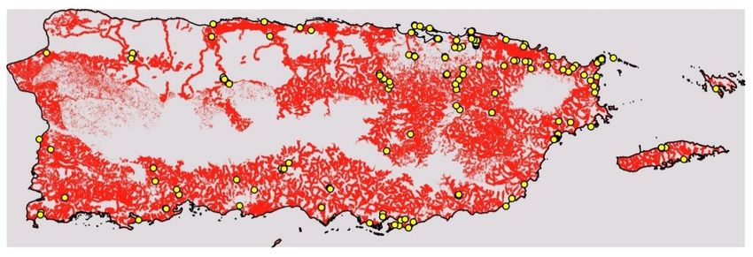
Life: The Excitement of Biology 7(4) ……………………………….….……………………… 182

underlying environmental factors at the local and landscape levels influence
distribution and dispersal into new regions (McPherson and Jetz 2007). With such
knowledge, managers are better able to determine where an invasive species could
disperse and to dedicate resources toward eradication of populations that have not
become established (Townsend and Vieglais 2001, Gibson et al. 2004, Gassó et
al. 2012)
     The genus Iguana is widely distributed in subtropical and tropical America.
Two species are currently recognized. The Lesser Antillean Iguana, Iguana
delicatissima Laurenti, 1768 (Reptilia: Iguanidae) is confined to the Lesser
Antilles, whereas the Green Iguana, Iguana iguana (Linnaeus, 1758), has the
widest distribution of all American iguanians (Etheridge 1982), with a native
range extending from Mexico to Paraguay and Brazil and into some of the Lesser
Antilles (Buckley et al. 2016, Henderson and Powell 2009, Savage 2002, and
Rivero 1998). Genetic studies of green iguanas have demonstrated that it is a
complex of at least two species, with evidence of cryptic lineages (Bock and
McCracken 1988, Stephen et al. 2013, Vuillaume et al. 2015, Breuil et al. 2019).
The latter also has been widely introduced, with accidental or intentional release
responsible for populations in the Antilles, including Puerto Rico, Dominican
Republic, Grand Cayman, southern Florida, and even some Pacific islands
(Falcón et al. 2013). In Puerto Rico, Green Iguana populations have expanded to
the point that they have become a nuisance, costing millions of dollars in damage
to infrastructure and agriculture (López-Torres et al. 2011, Falcón et al. 2012).
     Understanding IAS at regional and local scales is of extreme importance in
our globalized world (Meyerson and Mooney 2007). Nevertheless, few studies
have projected Green Iguana distributions at either local or regional levels, only
Falcón et al. (2012 and 2013) have considered current and potential distributions
of Green Iguanas outside their native range. Falcón et al. (2012) evaluated the risk
of spread of Green Iguanas in the Greater Caribbean Basin using the maximum
entropy niche-modeling algorithm (MaxEnt) to predict the potential distribution
using temperature and precipitation as predictor variables. This model had a high
predictive capability, predicting suitable habitats for iguanas in southern and
central coastal Florida and throughout the Caribbean Basin. Falcón et al. (2013),
using the same methodology, predicted a high climatic suitability for Green
Iguanas on many Pacific Islands, including those where the species has already
become established.
     To date, a model predicting current and potential distribution of Green
Iguanas in Puerto Rico has not been developed. Falcón et al. (2012) predicted
highly suitable areas for the species, especially along the coast, but their model
was based on temperature and precipitation data alone and did not consider
confirmed sightings. A model that considers crucial habitats for Green Iguanas
based on behavior, daily and seasonal needs, and confirmed geo-referenced
sightings is lacking. To meet the need of a more robust distribution model for
Green Iguanas, we employed the methodologies of the Puerto Rico Gap Analysis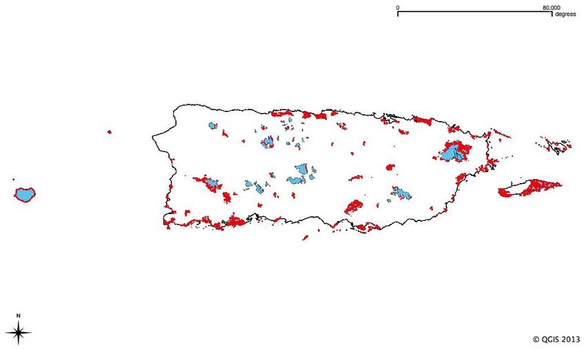
Life: The Excitement of Biology 7(4) ……………………………….….……………………… 183

Project (PRGAP) (Gould et al. 2008) to generate a distribution model for Green
Iguanas in Puerto Rico, using crucial habitats based the extensive literature
regarding the species’ natural history and presence data gathered in the field.

                                      Methods
     Presence Data for Iguana iguana. We gathered 173 data points in 48 of 78
municipalities in Puerto Rico from 16 December 2010 through 1 February 2011
and on 25 July 2011, using a Garmin 76CSx to mark and store the coordinates for
localities where Green Iguanas were present. We traveled by car along the major
roads in both the highlands and lowlands of Puerto Rico and, because iguanas are
known to frequent riparian habitats, we focused on rivers, artificial lakes, lagoons,
estuaries, mangrove forests, and protected areas. When a Green Iguana was
observed (alive or road-killed), we stopped and thoroughly searched for more
individuals in the area. If we were near a sighted individual, we marked its
position as a confirmed point. If the iguana was farther away, we marked the point
where we were and recorded an approximate distance and direction to the
individual. Later, using Google Earth 2011, aided by the general direction and
distance recorded in the field, we entered a new point marked as confirmed
presence.
     PRGAP Hexagon map: Iguana iguana presence. The PRGAP analysis
project uses a grid of hexagons (Figure 1) with an area of 24 km2 (Gould et al.
2008). Confirmed hexagons were based on points gathered in 2011. With the aid
of Facebook, we created an event called “I have Green Iguanas in my community”
with the purpose of confirming which communities close to areas already
confirmed, had Green Iguanas and which did not, in the process confirming the
presence of Green Iguanas in 30 municipalities. In addition, we called seven
mayoral offices and municipal government agencies in Aguada, Aguas Buenas,
Arroyo, Añasco, Barceloneta, Cataño, and Río Grande, which were not
exhaustively visited in our field trips, asking if they knew of any trouble with
Green Iguanas. Hexagons categorized as having a probable Green Iguana
presence were classified using our knowledge of the species’ habitat preferences
and requirements.
     Variables used to build the model. Variables selected to build the Green
Iguana distribution model for Puerto Rico were based on Savage (2002), who
noted that these lizards prefer riparian vegetation and gallery forests preferably
near water to elevations as high as 500 m above sea level. From the literature
(Bock et al 1998, Rand et al. 1989) and our experience in the field, we know that
Green Iguanas, especially females, can migrate as far as three kilometers to find
suitable nesting sites during the egg-laying season.
     The GIS layers used for this project were provided by the GIS lab of the
United States Forest Service, International Institute of Tropical Forestry (USFS-
IITF). The first layer was the PRGAP land cover map, from which we selected
only 50 of 70 land cover types thought to be crucial for Green Iguana survival
(Table 1).
Figure 1. Green Iguana distribution displayed on a map of Puerto Rico with 24-km2 hexagon grid. This map shows confirmed, and
probable hexagons based on points gathered in the field and expert opinion for the Green Iguana. Hexagons with probable Green
Life: The Excitement of Biology 7(4) ……………………………….….……………………… 184
Iguana presence are colored yellow. Hexagons with confirmed iguana presence are colored brown.Life: The Excitement of Biology 7(4) ……………………………….….……………………… 185
Table 1. Habitat types from the land cover map of the PRGAP analysis. These habitat types
were selected considering the daily and seasonal needs of Green Iguanas in Puerto Rico.
Iguana needs (Daily[D],
Habitat Type Description Seasonal [S], Transitional
[T])
Mature secondary lowland dry alluvial semi deciduous
D
forest
Young secondary lowland dry alluvial semi deciduous
D
forest
Lowland dry alluvial shrubland and woodland D
Mature secondary lowland dry limestone evergreen
D
forest
Mature secondary lowland dry limestone semi
D
deciduous forest
Young secondary lowland dry limestone semi
D
deciduous forest
Lowland dry limestone woodland and shrubland D
Lowland dry limestone shrubland D
Lowland dry cactus shrubland D
Coastal dwarf woodland and shrubland D
Lowland dry limestone cliffside semi deciduous forest D
Lowland dry limestone cliffside shrubland and
D
woodland
Mature secondary lowland dry non-calcareous semi
D
deciduous forest
Young secondary lowland dry non-calcareous semi
D
deciduous forest
Lowland dry non-calcareous shrubland and woodland D
Abandoned dry forest plantation D
Mature secondary lowland moist alluvial evergreen
D
forest
Young secondary lowland moist alluvial evergreen
D
forest
Lowland moist alluvial shrubland and woodland D
Mature secondary moist limestone evergreen and semi
D
deciduous forest
Young secondary moist limestone evergreen and semi
D
deciduous forest
Moist limestone shrubland and woodland D
Mature secondary lowland moist non-calcareous
D
evergreen forestLife: The Excitement of Biology 7(4) ……………………………….….……………………… 186
Young secondary lowland moist non-calcareous
D
evergreen forest
Lowland moist non-calcareous shrubland and
D
woodland
Lowland moist abandoned and active coffee
D
plantations
Mangrove forest and shrubland D
Freshwater Pterocarpus swamp D
Lowland dry riparian forest D
Lowland dry riparian shrubland and woodland D
Lowland moist riparian forest D
Lowland moist riparian shrubland and woodland D
Dry grasslands and pastures S
Dry cactus grassland and shrubland S
Fine to coarse sandy beaches, mixed sand and gravel
S
beaches
Riparian and other natural barrens S
Artificial barrens S and T
Moist grasslands and pastures T
Emergent herbaceous non-saline wetlands T
Emergent herbaceous saline wetlands T
Seasonally flooded herbaceous non-saline wetlands T
Seasonally flooded herbaceous saline wetlands T
Hay and row crops T
Woody agriculture and plantations: Palm plantations T
Rocky cliffs and shelves T
Salt and mudflats T
Salt production T
Freshwater T
Saltwater T
Aquiculture T
From our observations in the field and evidence from literature (e.g., Savage
2002, Meshaka et al. 2007, Krysko et al. 2007, López-Torres et al. 2011), daily
needs for all Green Iguana age classes include: (1) perching sites for
thermoregulation, displaying, and escape; (2) food items on the ground or inLife: The Excitement of Biology 7(4) ……………………………….….……………………… 187
surrounding vegetation; and (3) water for drinking, thermoregulation, and escape.
Seasonally, Green Iguanas require additional microhabitats, and they vary among
age classes. During the mating season from December to early March (López-
Torres et al. 2011), dominant males will compete and defend perch sites that are
both conspicuous to other iguanas and meet as many of the daily needs,
particularly those of females (Dugan 1982), as possible. During the nesting and
egg-laying season, from February to May (López-Torres et al. 2011), females
migrate as far as 3 km to find suitable nesting sites in Panama (Montgomery et al.
1973) and up to 1.5 km in Fajardo, Puerto Rico (Rodriguez-Gómez, personal
observation). Transitional needs include the habitats that separate the essential
daily and seasonal habitats.
Based on daily, seasonal, and transitional needs, we divided PRGAP land
cover types into three corresponding categories (Table 1). The daily-needs
category includes all lowland mature and secondary forests, woodlands, as well
as shrublands on limestone, non-calcareous, alluvial soils, and all riparian forests,
woodlands, and shrublands, mangroves, and Pterocarpus forests. The seasonal-
needs category includes all fine-to-course sandy beaches, riparian, natural, and
artificial barrens, as well as dry pastures. The transitional-needs category includes
roads, bodies of water, barrens, mud and salt flats, wet and dry pastures,
agricultural lands, as well as cliffs and shelves.
Another variable important in determining the distribution of Green Iguanas
was the presence of bodies of water. Using a hydrology map modified at the
USFS-IITF Lab, we identified all bodies of water, including creeks and rivers,
channels, lagoons, and artificial lakes, and added a buffer zone of 300 m
surrounding all bodies of water and the Puerto Rican coastline to the model on the
assumption that iguanas occupy habitats farther from the water’s edge and that
especially females engage in extensive migrations.
We delimited as suitable only the habitats that complied with iguana needs
(i.e. daily, seasonal or transitional) and proximity to bodies of water, at elevations
of ≤ 500 m above sea level (Figure 2). Although iguanas occur at elevations to
1000 m in Colombia (e.g., Etheridge 1982, Henderson and Powell 2009) and
iguanas have been observed along the shore of an artificial lake at an elevation >
500 m in the Carite National Forest in Puerto Rico (Rafael L. Joglar, personal
communication), we found no iguanas at elevations ≥ 500 m during our field
surveys. This should not be construed as a statement that iguanas do not occur at
higher elevations, only that they are less abundant there and that such localities
are unlikely to support dense populations.
In addition, we considered in one model only, all roads plus a buffer zone of
50 m, since many Puerto Rican roads are bordered by forest or vegetation
fragments and are used by Green Iguanas as suitable habitat as well as corridors
during migration. The problem with this layer was that it also includes developed
areas along the road, many of which are not necessarily suitable for iguanas.
Consequently, it might overestimate the presence of suitable habitats. To generateLife: The Excitement of Biology 7(4) ……………………………….….……………………… 188
our final model, we combined maps showing land-cover types, bodies of water,
elevations ≤ 500 m, and the presence and probable-presence hexagons.
Data analysis. We analyzed our data and constructed the final model using
ESRI-ArcGIS 10 and Quantum GIS 1.5.0. To test for differences in predictability
between the Green Iguana distribution models excluding and including roads, we
used chi-square tests in PAST statistics (2001) and Stat Plus: Mac (2009). For
statistical tests, alphas = 0.05. We also conducted an additional analysis to
determine how many of the 95 terrestrial protected areas of Puerto Rico were
predicted to have Green Iguanas and how many of those were confirmed in the
field.
Results
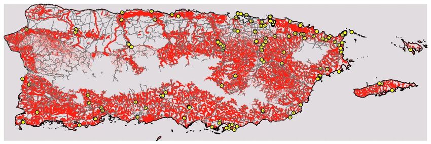
The distribution model that excluded roads (Figure 3) shows a potential range
throughout most of Puerto Rico and the islands of Vieques, Culebra, and adjacent
keys, with concentrations mostly in suitable habitats surrounding watersheds. In
areas of high urban density (San Juan metro area, Caguas, Ponce), Green Iguanas
are predicted to occur in vegetation patches (e.g., parks) and adjacent to bodies of
water. Green Iguana distribution, however, is patchy in the northwestern
limestone formations. The model including roads (Figure 4) was generally
similar, differing primarily in having a few more corridors (corresponding to
roads) deemed habitable.
Model 1 (no roads) correctly predicted 137 of 172 confirmed Green Iguana
presence points, an accuracy of 79.7%. The points not confirmed by this model
were either in high-density urban areas or in roadside vegetation, two variables
not considered by this model. Model 2 (with roads) successfully predicted 152 of
172 presence points, an accuracy of 88.4%.
When we tested, the null hypothesis was that predictive ability was
independent of the model used, the null hypothesis was rejected. The alternate
hypothesis, that predictive ability was related to the model used, revealed a
statistically significant difference between the predictive abilities of the models
(χ2 = 4.8695, p = 0.027336, df = 1), with the model including roads more efficient
in predicting Green Iguana distribution where the presence of the species had been
confirmed during field surveys.Figure 2. Map of Puerto Rico detailing the elevational distribution of Green Iguanas. Areas colored in light pink represent elevations equal
Life: The Excitement of Biology 7(4) ……………………………….….……………………… 189
to or below 500m above sea level. Areas in white represent areas above 500m above sea level, which are possibly without Green Iguanas.Figure 3. Model 1 for Green Iguana distribution in Puerto Rico. Yellow filled in circles represent confirmed GPS points with Green Iguana
presence. Proposed Green Iguana distribution is represented in red.
Life: The Excitement of Biology 7(4) ……………………………….….……………………… 190Figure 4. Model 2 for Green Iguana distribution in Puerto Rico. Yellow filled in circles represent confirmed GPS points with Green Iguana
presence. Proposed Green Iguana distribution is represented in red and grey. The grey lines represent roads and roadside habitats.
Life: The Excitement of Biology 7(4) ……………………………….….……………………… 191Figure 5. Map of Puerto Rico’s protected areas with probable Green Iguana presence. Areas in Blue represent all of Puerto Rico’s protected
Life: The Excitement of Biology 7(4) ……………………………….….……………………… 192
areas. The portions in red represent the protected areas where iguanas are predicted to be present with model 1.Life: The Excitement of Biology 7(4) ……………………………….….……………………… 193
Discussion
Both models were very efficient in predicting potential Green Iguana
distribution in Puerto Rico, with that including roads having a slightly greater
predictive ability. The inclusion of roads in the model has its pros and cons. Harris
(1982) documented a phenomenon he termed “highway madness” in Green
Iguanas of northern Colombia and Rodda (1990) described a similar pattern in
Venezuela, both noting that the attractiveness of roads accounts for a high
incidence of road-killed iguanas. Roadsides seem to be ideal nesting sites for
females, but also offer vantage points for males to display and thermoregulate.
In Puerto Rico, hundreds of road-killed Green Iguanas are seen along the
roads during the mating and egg-laying seasons. On 8 April 2009, we counted 36
road-killed Green Iguanas (mostly gravid females) on one side of a 13-km stretch
of highway. Field surveys indicate that Green Iguanas use roadsides and adjacent
habitats for perching, thermoregulation, displaying, courtship, and nesting. Roads
also appear to serve as both barriers and corridors. Roads as barriers fragment
habitats, but in doing so create edges, similar to habitats along rivers, mangroves,
and lakes, used by iguanas (Carlo and García-Quijano 2008). However, we also
think that roads and the adjacent fragmented habitats provide an extensive
corridor system for the movement, migration, and possible dispersal into new
habitats in Puerto Rico. More research on the effect of roads on Green Iguana
populations in Puerto Rico may warrant attention, for example differences in
population density and habitat use along roadside habitats in the reproductive
season versus the non-reproductive season.
Although the model including roads efficiently predicts Green Iguana
distribution in Puerto Rico, it might overestimate available habitats and thus
numbers of iguanas. Not all roadsides contain crucial habitats as many roads are
bordered by intensely developed urban areas uninhabitable by iguanas.
Consequently, because of the possibility of falsely predicting the presence of
Green Iguanas in many urban areas, we are inclined to prefer the model that
excludes roads. Future models should incorporate fine-scale analyses that
differentiate between different kinds of roads or perhaps a preference for one
model over the other should be determined by a consideration of roadside
conditions.
Regardless, both models indicate that Green Iguanas are widely distributed
throughout Puerto Rico. Even more impressive is the realization that 86.3%
(82/95) of Puerto Rico’s protected areas are intersected by the distribution model
excluding roads. That iguanas were not predicted to occur in protected areas at
elevations > 500 meters was to be expected since the model was limited to
elevations ≤ 500 m, but what we did not expect was finding protected areas at
elevations < 500 m without Green Iguanas. Particularly interesting was the fact
that all but one of these lowland protected areas, excepting Servidumbre de
Conservación Montes Oscuros, were concentrated in the northwestern limestone
region of Puerto Rico. These limestone formations, characterized by vast caveLife: The Excitement of Biology 7(4) ……………………………….….……………………… 194
systems and subterranean rivers, possibly limiting the extent of extensive riparian
corridors, supports unique habitats exploited by native and endemic flora and
fauna. This region is also under constant threat from development. As a
consequence, a high concentration of protected areas in this region serve to protect
species like the critically endangered Puerto Rican Parrot, Amazona vittata
Boddaert, 1783; the Puerto Rican Boa, Chilabothrus inornatus (Reinhardt, 1843);
and are sites of efforts to reintroduce depleted populations of the Puerto Rican
Crested Toad, Peltophryne lemur Cope, 1869. The models not predicting the
presence of Green Iguanas in these protected areas should not be interpreted to
imply that they are not present (although suboptimal habitat probably limits
numbers). Nevertheless, for a region of such high conservation importance, this
may be a good sign. Federal, state, and private land managers should pay special
attention to the possible dispersal of Green Iguanas into the regions of Puerto Rico
and apply their limited available resources to develop clear objectives regarding
the management of this species.
The models presented herein should be useful for land managers, who can
determine what crucial habitats exist for Green Iguanas in a given protected area
and use that information to make important decisions regarding where to survey
Green Iguana populations and where to most effectively control the populations
(e.g., nesting sites). Nevertheless, we would consider including mean annual
precipitation and temperature into the Green Iguana distribution models. High
population densities and reproductive season in Puerto Rico appear to be
correlated with temperature (López-Torres et al. 2011), so including temperature
and precipitation layers into our models should enhance their predictive ability.
In the future, we also propose increasing the elevational buffer to 1000 m and
analyzing the extended suite of variables using MaxEnt (as in Falcón et al. 2012,
2013).
Acknowledgements
We want to thank Sebastian G. Rodríguez, Stephanie M. Rodríguez, Mariely Rodríguez Medina,
and Mario Cancel for help in gathering Green Iguana presence data. We also thank the municipal
mayoral and emergency management offices of the Commonwealth of Puerto Rico for providing
useful information on the presence of iguanas in their communities. We also want to thank Dr. Robert
Powell for his insightful comments and opinions on this paper. The University of Puerto Rico, Río
Piedras Campus provided funding via the Puerto Rico Louis Stokes Alliance for Minority Participation
-Bridge to the Doctorate Scholarship (Grant number: HRD-0601843), Department of Biology
Formative Academic Experiences Program and the Dean of Graduate Studies and Research - Golf
Tournament Scholarship. We also are immensely thankful to the USFS-International Institute of
Tropical Forestry GIS lab for expert advice and for the use of equipment and software. All research at
the USDA International Institute of Tropical Forestry was done in collaboration with the University
of Puerto Rico.
Literature Cited
Belongie, C. 2008. Using GIS to Create a Gray Wolf Habitat Suitability Model and to Assess Wolf
Pack Ranges in the Western Upper Peninsula of Michigan. Volume 10. Papers in Resource
Analysis. 15pp. Saint Mary’s University of Minnesota Central Services Press. Winona,
Minnesota, USA. Retrieved on February 22, 2020 from http://www.gis.smumn.edu,
http://www2.smumn.edu/ra/gis/gradprojects/belongiec.pdfLife: The Excitement of Biology 7(4) ……………………………….….……………………… 195
Bock, B. C. and G. F. McCracken. 1988. Genetic structure and variability in the Green Iguana (Iguana
iguana). Journal of Herpetology 22(3): 316–322. https://doi.org/10.2307/1564155
Bock, B. C., V. P. Páez, and S. A. Rand. 1998. Temperaturas del suelo atípicas en áreas de anidación
de la iguana verde (Iguana iguana) en Colombia y Panamá. Crónica Forestal y del Medio
Ambiente13(1):55-70.
Breuil, M., B. Vuillaume, D. Schikorski, U. Krauss, M. N. Morton, P. Haynes, J. C. Daltry, E. Corry,
G. Gaymes, J. Gaymes, N. Bech, M. Jelic, and F. Grandjean. 2019. A story of nasal horns: Two
new subspecies of Iguana Laurenti, 1768 (Squamata, Iguanidae) in Saint Lucia, St Vincent &
the Grenadines, and Grenada (southern Lesser Antilles). Zootaxa 4608: 201–232.
https://doi.org/10.11646/zootaxa.4608.2.1
Brotons, L., W. Thuiller, M. B. Araújo, and H. Hirzel. 2004. Presence-absence versus presence-only
modeling methods for predicting bird habitat suitability. Ecography 27:437–448.
https://doi.org/10.1111/j.0906-7590.2004.03764.x
Carlo, T. A. and C. G. Garía-Quijano. 2008 (September 20). Assessing ecosystem and cultural impacts
of the Green Iguana (Iguana iguana) invasion in the San Juan Bay Estuary (SJBE) in Puerto
Rico. Unpublished Final Report for SJBE.
Corsi, F., J. de Leeuw, and A. K. Skidmore. 2000. Modeling species distribution with GIS. pp. 320-
339. In, Boitani, L., and T. K. Fuller (Editors). Research Techniques in Animal Ecology:
Controversies and Consequences. Columbia University Press. New York, NY, USA. 442 pp.
Dugan, B. 1982 The mating behavior of the Green Iguana, Iguana iguana. pp. 320-339. In, Burghardt,
G. M. and A. S. Rand (Editors). Iguanas of the World: Their Behavior, Ecology, and
Conservation. Noyes Series in Animal Behavior, Ecology, Conservation and Management. Park
Ridge, New Jersey, USA. 474 pp.
Etheridge, R. 1982. Checklist of the iguanine and Malagasy iguanid lizards. pp. 7-37. In, Burghardt,
G. M. and A. S. Rand (Editors). Iguanas of the World: Their Behavior, Ecology, and
Conservation. Noyes Series in Animal Behavior, Ecology, Conservation and Management. Park
Ridge, New Jersey, USA. 474 pp.
Falcón, W., J. D. Ackerman, and C. C. Daehler. 2012 (September). March of the Green Iguana: Non-
native distribution and predicted geographic range of Iguana iguana in the greater Caribbean
region. IRCF (International Reptile Conservation Foundation) Reptiles and Amphibians10(3):
150–160. https://www.researchgate.net/publication/231521613_March_of_the_green_iguana_Non-
native_distribution_and_predicted_geographic_range_of_Iguana_iguana_in_the_Greater_Caribbean
_Region
Falcón, W., J. D. Ackerman, W. Recart, and C. Daehler. 2013. Biology and impacts of Pacific island
invasive Species. 10. Iguana iguana, the Green Iguana. Pacific Science 67(2):157-186.
https://doi.org/10.2984/67.2.2
Gassó, N., W. Thuiller, J. Pino, and M. Vilà. 2012. Potential distribution range of invasive plant
species in Spain. NeoBiota 12: 25 – 40. https://doi.org/10.3897/neobiota.12.2341
Gibson, L. A., B. A. Wilson, D. M. Cahill, and J. Hill. 2004. Spatial prediction of rufous bristlebird
habitat in a coastal heathland: a GIS – based approach. Journal of Applied Ecology 41:213-223.
https://doi.org/10.1111/j.0021-8901.2004.00896.x
Gould, W. A., C. Alarcón, B. Fevold, M. E. Jiménez, M. Martinuzzi, G. Dotts, M. Quiñonez, M.
Solórzano, and E. Ventosa. 2008. The Puerto Rico Gap Analysis Project. Volume 1. Landcover,
Vertebrate Species, Distributions and Land Stewardship. United States Department of
Agriculture. Forest Service. General Technical Report. International Institute of Tropical
Forestry General Technical Report IITF-GTR-39. 165 pp. Published
online. https://doi.org/10.2737/IITF-GTR-39
Harris, D. M. 1982. The phenology, growth, and survival of the Green Iguana, Iguana iguana pp. 150-
161. In, Burghardt, G. M. and A. S. Rand (Editors). Iguanas of the World: Their Behavior,
Ecology, and Conservation. Noyes Series in Animal Behavior, Ecology, Conservation and
Management. Park Ridge, New Jersey, USA. 474 pp.
Henderson, R. W. and R. Powell. 2009. Natural History of West Indian Reptiles and Amphibians.
University Press of Florida. Gainesville, Florida. USA. 528 pp.
Buckley, L. J., K. De Queiroz, T. D. Grant, B. D. Hollingsworth, J. B. Iverson, S. A. Pasachnik, andLife: The Excitement of Biology 7(4) ……………………………….….……………………… 196
C. L. Stephen (Iguana Taxonomy Working Group). 2016. A checklist of the Iguanas of the World
(Iguanidae; Iguaninae). In, Iverson, J. B., T. D. Grant, C. R. Knapp, and S. A. Pasachnik
(Editors). Iguanas: Biology, Systematics, and Conservation. Herpetological Conservation and
Biology 11 (Monograph 6):4-46. http://www.herpconbio.org/Volume_11/Monograph_6/2-
Iguana_Taxonomy_Working_Group_2016.pdf
Krysko, K. L., K. M. Enge, E. M. Donlan, J. C. Seitz, and E. A. Golden. 2007. Distribution, natural
history and impacts of the introduced Green Iguana (Iguana iguana) in Florida. Iguana 14(3):
142-151.
López-Torres, A. L., H. J. Claudio-Hernández, C. A. Rodríguez-Gómez, A. V. Longo, and R. L.
Joglar. 2011. Green Iguanas (Iguana iguana) in Puerto Rico: is it time for management?
Biological Invasions 14(1):3 –45. https://doi.org/10.1007/s10530-011-0057-0
Lugo, A. E. and J. M. Wunderle Jr. 2012 Natural mixing of species: novel plant – animal communities
on Caribbean Islands. Animal Conservation 15:233-241.https://doi.org/10.1111/j.1469-
1795.2012.00523.x
McPherson, J. M. and W. Jetz. 2007. Effects of species’ ecology on the accuracy of distribution
models. Ecography 30:135–151. https://doi.org/10.1111/j.0906-7590.2007.04823.x
Meshaka Jr., W. E., H. T. Smith, E. Golden, J. A. Moore, S. Fitchet, E. M. Cowan, R. M. Engeman,
and S. R. Sekscienski. 2007. Green Iguanas (Iguana iguana): The unintended consequence of
sound wildlife management practices in a South Florida. Herpetological Conservation and
Biology 2:149–156.
Meyerson, L. and H. A. Mooney. 2007. Invasive alien species in an era of globalization. Frontiers in
Ecology and the Environment 5(4):199–208.
https://doi.org/10.1890/15409295(2007)5[199:IASIAE]2.0.CO;2
Montgomery, G. G. 1973. Post-nesting movements of iguanas from a nesting aggregation. Copeia
3:620–622. https://doi.org/10.2307/1443141
Rand, A. S., E. Font, D. Ramos, D. I. Werner, and B. C. Bock. 1989. Home range in Green Iguanas
(Iguana iguana) in Panama. Copeia 1989(1):217–221. https://doi.org/10.2307/1445631
Rivero, J. A. 1998. Los Anfibios y Reptiles de Puerto Rico. Segunda Edición Revisada. The
Amphibians and Reptiles of Puerto Rico. Editorial de la Universidad de Puerto Rico. San Juan,
Puerto Rico. 510 pp.
Rodda, G. H. and A. Grajal. 1990. The nesting behavior of the Green Iguana, Iguana iguana in the
llanos of Venezuela. Amphibia-Reptilia 11: 31–39. https://doi.org/10.1163/156853890X00294
Savage, J. M. 2002. The Amphibians and Reptiles of Costa Rica: A Herpetofauna between Two
Continents, between Two Seas. The University of Chicago Press. Chicago, Illinois, USA. 934
pp.
Stephen, C. L., V. H. Reynoso, W. S. Collet, C. R. Hasban, and J. W. Breinholt. 2013. Geographical
structure and cryptic lineages within common green iguanas, Iguana iguana. Journal of
Biogeography 40:50–62. https://doi.org/10.1111/j.1365-2699.2012.02780.x
Strayer, D. L. 2012. Eight questions about invasions and ecosystem functioning. Ecology Letters
15(10):1199-1210. https://doi.org/10.1111/j.1461-0248.2012.01817.x
Townsend–Peterson, A. and D. A. Vieglais. 2001 Predicting species invasions using ecological niche
modeling: new approaches from bioinformatics attack a pressing problem. BioScience
51(5):363–371. https://doi.org/10.1641/0006-3568(2001)051[0363:PSIUEN]2.0.CO;2
Vuillaume, B., V. Valette, O. Lepais, F. Grandjean, and M. Breuil. 2015. Genetic evidence of
hybridization between the endangered native species Iguana delicatissima and the invasive
Iguana iguana (Reptilia, Iguanidae) in the Lesser Antilles: Management implications. PLoS One
10(6).e0127575. https://doi.org/10.1371/journal.pone.0127575You can also read


