2020 Biographies HSRP FAC Panel Members - NOAA ...
←
→
Page content transcription
If your browser does not render page correctly, please read the page content below
Updated Oct 27, 2020

2020 Biographies HSRP FAC Panel Members
HSRP voting members                                  PAGE
Dr. Qassim Abdullah                                  2
Capt. Anuj Chopra                                    2
Mr. Sean M. Duffy, Sr.                               3
Dr. Nicole Elko                                      4
Mr. Lindsay Gee                                      4
Ms. Deanne Hargrave                                  5
Mr. Edward Kelly                                     5
Capt. Ann Kinner                                     6
Dr. David F. Maune                                   7
Capt. Anne McIntyre                                  8
Captain (ret. USCG) Ed Page                          8
Capt. Salvatore Rassello                             8
Mr. Edward J. Saade                                  9
Ms. Julie Thomas                                     10
Mr. Gary Thompson                                    11

HSRP non-voting members
Capt. (NOAA, Ret.) Andrew A. Armstrong III           12
Ms. Juliana P. Blackwell                             13
Mr. Richard Edwing                                   13
Dr. Larry Mayer                                      14

Designated Federal Official
Rear Admiral Shepard M. Smith                        15

Dr. Qassim Abdullah
Dr. Qassim Abdullah, Vice President and Chief Scientist, Woolpert, Inc., Adjunct Professor,
Penn State and UMBC

                                 Dr. Qassim Abdullah is a scientist with more than 40 years of
                                 combined industrial, research and development (R&D), and
                                 academic experience in analytical photogrammetry, digital remote
                                 sensing, and civil and surveying engineering. His current
                                 responsibilities include designing and managing strategic programs
                                 to develop and implement new remote sensing technologies focused
                                 on meeting the evolving needs of geospatial users. He is the Chief
                                 Scientist for Woolpert Geospatial Services and a member of the
                                 Woolpert Labs R&D team. He serves as an adjunct professor at the
                                 University of Maryland, and at Penn State, where he teaches
                                 graduate courses on unmanned aircraft systems (UAS),
                                 photogrammetry and remote sensing. He evaluated and introduced a
Geiger-mode and single photon lidar to the geospatial industry while leading Woolpert research
activities surrounding UAS sensor calibration and workflow development. He publishes a monthly
column, “Mapping Matters,” in the American Society for Photogrammetry and Remote Sensing
(ASPRS) journal, PE&RS and has several prestigious awards from ASPRS such as the Life Time
Achievement Award and the Photogrammetric Fairchild award. He co-authored the new “Positional
Accuracy Standards for Digital Geospatial Data”. Dr. Abdullah is a certified photogrammetrist and
licensed professional surveyor and mapper in Florida, Oregon, Virginia and South Carolina. He is
also a certified thermographer through the FLIR Infrared Training Center and a Certified GEOINT
Professional in Remote Sensing and Imagery Analysis (CGP-R) through the United States Geospatial
Intelligence Foundation (USGIF). Dr. Abdullah obtained his doctorate and master degrees in
photogrammetry from the Civil Engineering Department at the University of Washington in Seattle.

                                    Capt. Anuj Chopra
Capt. Anuj Chopra, Vice President - Americas, RightShip

                                     With over 30 years maritime experience both at sea and
                                     onshore, Capt. Chopra drives business development, leads the
                                     vetting team, and fosters industry and customer relations in the
                                     Americas region focused on risk management for the maritime
                                     industry. Rightship’s mission is to improve the safety and
                                     environmental sustainability of the maritime industry. He is the
                                     regional business head, leading the vetting team in assessment
                                     and management of risk associated with vessel operations,
                                     liaising with entities to improve maritime and environmental risk
                                     management for the industry, liaising with ports for incentivizing
                                     sustainable shipping, and ensuring business regulatory
                                     compliance. He formerly served in risk management roles for
                                     the Anglo-Eastern Group, a company with 545 ships including
                                       Page 2 of 15
170 in the U.S. where he served as the President with operational responsibility for risk evaluation,
assessment and mitigation, and as the U.S. representative handling fleet operations. Capt. Chopra
began his seafaring career as a deck cadet working his way up to Captain and holds a
Commonwealth Extra Masters Certificate of Competency, and Shipping Management from the Indian
Institute of Management, Ahmedabad. He serves on the following: fellow, The Nautical Institute, and
chairman of the U.S. Gulf Branch; as a supporter of seafarer welfare, he’s an Ambassador for the
Sailor Society; member, Board of Directors of the Houston International Seafarers Center; President,
the Industry Advisory Board for the Supply Chain and Logistics Technology Degree at the University
of Houston; and member, Board of Directors (and Treasurer) of NAMEPA – North American Marine
Environment Protection Association.

                                   Mr. Sean M. Duffy, Sr.
Mr. Sean M. Duffy, Sr., Executive Director, Big River Coalition

                                   Mr. Duffy directs the Big River Coalition which is committed to
                                   protecting maritime commerce across the Mississippi River and
                                   Tributaries (MRT). He leads the Coalition which focuses on
                                   maximizing transportation efficiencies on the deep-draft ship channel
                                   from Baton Rouge to the Gulf of Mexico with a dedicated focus on
                                   channel maintenance. The Big River Coalition is at the forefront of
                                   efforts to deepen the Mississippi River Ship Channel to 50 feet. He
                                   spearheads the visions of the future of the MRT to ensure that
                                   systematic approaches protect maritime trade by maintaining fully
                                   authorized channel dimensions while also updating and maintaining
                                   navigation infrastructure, specifically the locks and dams along the
                                   MRT. The Big River Coalition missions are focused on securing
                                   increased funding from the Harbor Maintenance Tax and the Inland
Users Fuel Tax, efforts to deepen the Lower Mississippi River to 50 feet and to increase the beneficial
use of dredge material or “sediment recycling.” Mr. Duffy also serves as an Executive Vice President /
Maritime Advocate for the parent company the New Orleans Steamship Association d.b.a. Louisiana
Maritime Association. Mr. Duffy is a proponent for local industry specializing in advocating on Capitol
Hill to secure supplemental funds for maintenance dredging and waterway maintenance. Previous
employment experiences include various management positions, Boarding Agent, Deckhand,
Stevedore General Superintendent and Marine Surveyor. Mr. Duffy is familiar with obstacles faced by
the maritime industry, both nationally and those specific to Louisiana, and has been recognized for
his efforts on coastal restoration through maintenance dredging.

                                        Dr. Nicole Elko
Dr. Nicole Elko, Science Director, American Shore and Beach Preservation Association
(ASBPA), Executive Director of the South Carolina Beach Advocates, and President of Elko Coastal
Consulting

Dr. Nicole Elko is one of the three civilian members of the U.S. Army Corps of Engineers’ Coastal
Engineering Research Board (CERB). She received her Ph.D. (Geology) from the University of South

                                         Page 3 of 15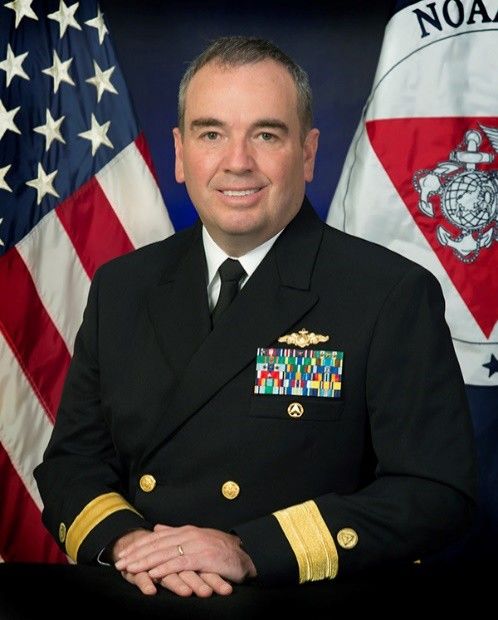
Florida after working with the USGS Coastal Marine Geology Program, and while serving as the
coastal coordinator for Pinellas County, FL. Dr. Elko has 20 years of experience in coastal resource
management and has managed or assisted with more than 20 beach preservation projects along the
                                          U.S. Southeast and Gulf coasts. She works with various State
                                          and Federal agencies to communicate the coastal resilience
                                          needs of local communities. Dr. Elko has co-authored a book
                                          on coastal management, numerous technical reports, and 16
                                          journal publications, including The Future of Nearshore
                                          Processes Research, a seminal report that provides a
                                          research vision developed by the nearshore community. At
                                          ASBPA, Dr. Elko helps provide science-based guidance to
                                          Congress, Federal and State agencies, and local communities
                                          on national coastal resilience challenges. She serves a co-
                                          Executive Director for the grass-roots U.S. Coastal Research
                                          Program. Regionally, Dr. Elko serves on South Carolina
Governor McMaster’s Floodwater Commission, and the Southeast Coastal Ocean Observing
Regional Association (SECOORA) Science Committee. Her business provides hydrographic
surveying, coastal research and advocacy services. Dr. Elko teaches a “Beaches 101” training course
to regulators and elected officials in the Carolinas.

                                       Mr. Lindsay Gee
Mr. Lindsay Gee, Mapping and Science Coordinator, Ocean Exploration Trust

                                  Mr. Lindsay Gee joined the Ocean Exploration Trust and coordinates
                                  the science and mapping activities conducted on the E/V Nautilus.
                                  He has four decades of broad experience working in the international
                                  hydrographic surveying and ocean mapping industry. This
                                  experience ranged from working at a national hydrographic service,
                                  then consulting in the broader offshore industry, and leading a small
                                  innovative company providing software and services to the
                                  international hydrographic industry. His roles included conducting
                                  and managing operational hydrographic surveys for nautical
                                  charting, client representation for geodetic and geo-hazard surveys
                                  in the oil and gas industry, through to leading a team in development
of software applications to support hydrographic surveying and ocean mapping. During the latter 15
years he built a deep understanding and expertise in guiding the transfer of technology from research
at partner ocean mapping research institutions, and leading the development of an agile company to
successfully interpret industry requirements and trends. His most recent consulting was focused on
the technology used in the ocean mapping industry, and the strategic planning and business
development required to identify and transition innovative technology to products, services and
solutions for general operational use. Mr. Gee is affiliated with the Hydrographic Society of America,
Surveying and Spatial Sciences Institute, Australasian Hydrographic Society, Marine Technology
Society and American Geophysical Union.

                                         Page 4 of 15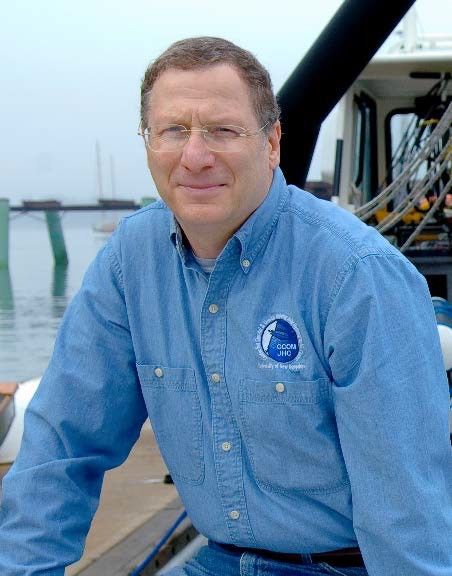
Ms. Deanne Hargrave
Ms. Deanne Hargrave, Geoscience Manager, Atlantic Shores Offshore Wind LLC

                                  Ms. Hargrave is planning, executing and delivering technically
                                  complex and logistically challenging offshore geophysical projects for
                                  Atlantic Shores Offshore Wind LLC, a joint venture with Shell and
                                  EDF Renewables. Over the past 20 years, she has conducted
                                  numerous shallow hazard surveys, geotechnical investigations, seep
                                  surveys, and navigational positioning projects at worldwide locations.
                                  Deanne strives to anticipate industry technical requirements, interpret
                                  regulatory trends, and adopt innovative technologies. She began her
                                  career in 1998 as a geotechnical engineer conducting onshore
                                  investigations with GeoEngineers. Beginning in 2004, she was project
                                  manager and party chief for offshore geophysical and geotechnical
                                  investigations throughout Alaska and was instrumental in creating
                                  Geo LLC, a company specializing in shallow hazard surveys for the oil
and gas industry. In 2011, after acquisition of Geo LLC by Fugro, she was promoted to Operations
Manager for Fugro Geo Services - Alaska, supervising technical personnel, implementing quality,
health, safety and environmental management systems, and managing operations/logistics for large
offshore projects in Alaska, Caribbean, Brazil, and New Zealand. In 2014, she joined Shell in Alaska
to deliver seabed clearance/geotechnical investigations and environmental baseline surveys. Deanne
was responsible for implementing Shell’s multi-year Marine Mammal Monitoring and Mitigation
Program, including an industry-leading underwater sound source verification program, and improved
logistics and operational efficiency by managing project risks and collaborating with stakeholders.
She also successfully identified two innovative methods for completing subsea construction activities
necessary in Arctic waters. She completed a B.S. in Civil Engineering at Gonzaga University,
continuing education in Arctic Engineering and Project Management at the University of Alaska
Anchorage, and is a Professional Engineer licensed in Alaska and Texas.

                                  Mr. Edward (Ed) J. Kelly
Mr. Edward Kelly, Executive Director, Maritime Association of the Port of New York/New
Jersey

Mr. Kelly is the Executive Director of the Maritime Association of the Port of New York/New Jersey.
Founded in 1873, the Maritime Association has a proud history of serving as a Maritime Exchange,
industry association, and general advocate of the Maritime-related activities of the tri-state Port. Ed is
responsible for managing the activities of the Association and developing the enhanced safety,
security, ecological sanctity, and economic viability of the many maritime – related industries in the
Port. Ed held a series of senior executive level positions in the Liner business including: President
and CEO of Cho Yang (America), Inc.; Senior Vice President of Inchcape Shipping Services;
President and CEO of Nippon Liner Systems (USA); and Executive Vice President of Y.S. Line
(USA). He provided executive level consulting services to firms such as Maher Terminals, Inc.; The
Port Authority of New York and New Jersey; Deutche Afrika Line; Paul F. Richardson Associates; the

                                          Page 5 of 15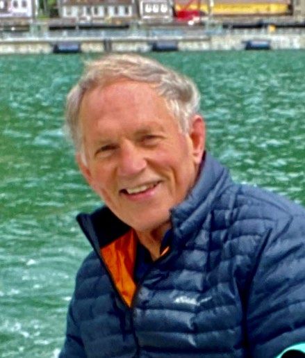
Maritime Association of the Port of New York; and Strachan Shipping
                             Agency. Ed had managed the Transportation, Logistics, and
                             Management Division of the Global Maritime and Transportation School
                             of the U.S. Merchant Marine Academy at Kings Point, New York. Ed
                             has devoted many years as a Director of the New York Shipping
                             Association, the Carriers Container Council, the USMX, and the
                             Steamship Operators Intermodal Committee and served on joint labor
                             /management committees and trust funds. He is the President of the
                             Maritime Information Service of North America (MISNA), Vice President
                             of the National Association of Maritime Organizations (NAMO), Vice
                             Chairman of the Mid Atlantic Regional Association Coastal Ocean
                             Observing System (MARACOOS), a Director of the United Seaman’s
                             Service, and a Director of the Urban Assembly School of Global Trade
and Transport. He was named as a member of New York City’s Mayoral Maritime Advisory Board. A
graduate of the U.S. Merchant Marine Academy, he sailed as a deck officer on U.S. Flag ships. Ed
completed an MBA at Pace University and has a certificate in Intermodal Transportation from the
FDR Institute. He received an award for Outstanding Professional Achievement from the Kings Point
Alumni Association and in 2009, the Journal of Commerce named Ed to their Leadership Roll in the
Global Logistics Industry.

                                       Capt. Ann Kinner
Capt. Ann Kinner, Owner, Seabreeze Books and Charts, and Chair, San Diego Harbor
Safety Committee, San Diego, CA

                                          Capt. Ann Kinner owns and manages Seabreeze Books and
                                          Charts in San Diego, California, which provides navigation
                                          tools and publications to all sectors of the maritime community,
                                          as well as charts provided by hydrographic services from
                                          Canada, Mexico, France, the British Admiralty, NOAA, NGA,
                                          and offers digital navigation products from Nobeltec and C-
                                          Map for use on a variety of on-board systems and personal
                                          computers. In addition to instructing boaters in the operations
                                          and systems of sail and power vessels, she worked with
                                          TowBoat/US as the primary watch-stander and rescue boat
                                          driver in San Diego. Her nearly 15 years with the Coast Guard
                                          Auxiliary and more than three decades of teaching all things
boating give her a broad perspective on the needs, curiosities, and varied interests of the recreational
and professional boating communities. She was appointed to the San Diego Harbor Safety
Committee, and has served as the Chair since July 2016. Frequently called upon to speak to boating
associations, she assisted with navigational guidance for the CUBAR powerboat rally from San Diego
to La Paz, Baja California, and was a speaker and instructor for the annual Women’s Sailing
Convention in Newport Beach. Capt. Kinner grew up sailing in Narragansett Bay, Rhode Island. She
has a lifetime love of the ocean, is a live-aboard boater, experienced on sail and power boats - both
simple and high-tech, and is familiar with harbors from Ensenada to Santa Barbara.

                                          Page 6 of 15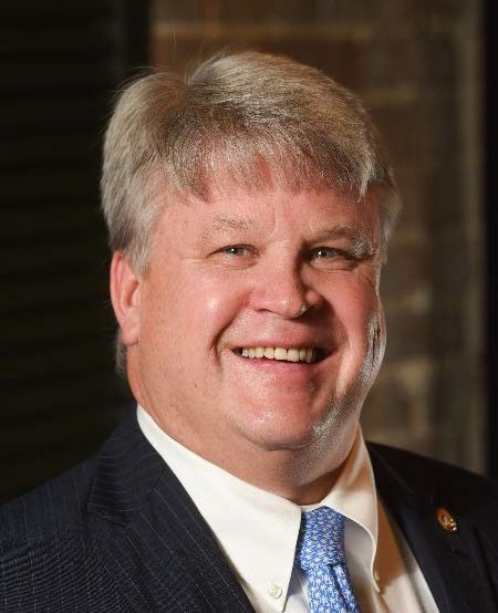
Dr. David Maune
Dr. David F. Maune, PhD, CP, CFM, PSM, PS, GS, SP
Associate Vice President and Senior Remote Sensing project manager, Dewberry Engineers,
Inc.
                                    Dr. David Maune manages major geospatial products and
                                    services contracts with the U.S. Geological Survey (USGS) and
                                    the National Oceanographic and Atmospheric Administration
                                    (NOAA) – both the National Geodetic Survey (NGS) and the
                                    Office for Coastal Management (OCM). He earned his MS and
                                    PhD degrees in geodesy and photogrammetry from The Ohio
                                    State University. He authored and co-authored major positional
                                    accuracy standards, guidelines and specifications published by
                                    the Federal Emergency Management Agency (FEMA), the
                                    National Digital Elevation Program (NDEP), and the American
                                    Society for Photogrammetry and Remote Sensing (ASPRS),
                                    including the ASPRS Positional Accuracy Standards for Digital
Geospatial Data (2014). He is a specialist in topographic mapping and elevation data and is the editor
of three editions of ASPRS’s “Digital Elevation Model Technologies and Applications: The DEM
“Users Manual”. For NOAA, he authored the National Height Modernization Study, Report to
Congress, on how to modernize the national height system. For USGS, he authored the National
Enhanced Elevation Assessment that served as the blueprint for the 3D Elevation Program (3DEP)
which focuses on standardized lidar mapping nationwide. For the U.S. Army Corps of Engineers
(USACE), he authored EM 1110-1-1000, Photogrammetric and Lidar Mapping (2015). He managed
Dewberry’s statewide mapping of Alaska with airborne interferometric synthetic aperture radar
(IFSAR) to satisfy urgent requirements for aviation safety and to help the state and federal agencies
to manage the vast natural resources in America’s Last Frontier. He is a retired U.S. Army Colonel,
and served as Director, U.S. Army Topographic Engineering Center (TEC). He is an ASPRS Fellow
and charter member of the National Geospatial Advisory Committee (NGAC); an ASPRS Certified
Photogrammetrist (CP); and an ASFPM Certified Floodplain Manager (CFM). His recent awards
include: 2016 ASPRS Photogrammetric Award; and the 2018 Outstanding Personal Achievement in
Lidar Award from the International LiDAR Mapping Forum (ILMF).

                                      Captain Anne McIntyre
                         Captain Anne McIntyre, Business Manager, San Francisco Bar
                         Pilots

                         Capt. Anne L. McIntyre is a 1988 deck officer graduate of the California
                         Maritime Academy. Upon graduation she was hired by Chevron Shipping
                         Co. and served 8 years in both sea-going and shore-based positions. In
                         1996, she was selected by the Oregon Board of Maritime Pilots to become
                         the first woman Columbia River Pilot. During her tenure as a Pilot, she has
                         served in a number of management positions including Administrative Pilot,
                         Commissioner, Oregon Board of Maritime Pilots and Vice Chair of the Lower
                         Columbia River Harbor Safety Committee. In 2013, she earned a MS in
                                         Page 7 of 15
Transportation and Engineering Management, also from the California Maritime Academy where she
is an active member of the CMA Alumni Association. In 2020, she retired as a Columbia River Pilot
and charted a new course as Business Director for the San Francisco Bar Pilots. In her spare time
she enjoys sailing, reading, as well as a variety of snow and water sports and viticulture.

                             Captain (ret. USCG) Ed Page
Captain Ed Page, U.S. Coast Guard (Retired), Executive Director, Marine Exchange of
Alaska

                                 A 1972 graduate of the U.S. Coast Guard Academy, Captain Page
                                 sailed on Coast Guard vessels sailing Atlantic, Pacific and Alaska
                                 waters followed by assignments in marine safety, environmental
                                 protection and search and rescue. Later in his Coast Guard career he
                                 held positions as Chief of Environmental Protection during the Exxon
                                 Valdez oil spill response, as Captain of the Port for Los Angeles-Long
                                 Beach and as Chief of Marine Safety and Environmental Protection for
                                 Coast Guard Pacific Area. After retiring from the Coast Guard in 2001
                                 he established the non-profit Marine Exchange of Alaska and led the
                                 development of an extensive Automatic Identification System (AIS) for
                                 Alaska comprised of over 130 AIS receivers extending throughout
                                 Southeast Alaska, the Aleutian Islands and the Arctic. This vessel
tracking system is used and largely funded by the Coast Guard, the State of Alaska and the maritime
industry. With assistance from the Alaska Ocean Observing System (AOOS) he has implemented the
installation of environmental stations at over 50 locations in Alaska that transmit weather data to
mariners over the AIS network and via the internet. He also engaged the Marine Exchange in a
Cooperative Research and Development Agreement with the Coast Guard R&D Center to develop an
Arctic, Next Generation Navigational Safety Information System that is providing the capability to
communicate information on the location of dynamic marine protected areas and safety information to
vessels using AIS. Ed is an avid kayaker and sailor and lives in Juneau with his wife Barbara.

                              Captain Salvatore Rassello
Captain Salvatore Rassello, Director, Nautical Operations, Carnival Cruise Lines (retired)

                               Captain Rassello served as Captain on Carnival Cruise line ships
                               (2006-2014) and as Nautical Director (2014 -2020) for the shore-side
                               marine operations at the Company headquarters in Miami. He has
                               expertise in maritime operations related to navigation, as a vessel
                               operator, in port operations at the corporate level, and port
                               administration. As Fleet Captain for Corporate Maritime Quality
                               Assurance, he has background in maritime safety culture and
                               knowledge of corporate and industry standards. He represented the
                               cruise industry as a member of the Cruise Lines International
                               Association’s (CLIA) Navigation & Hydrographic Working Group and
                               Operations Working Group, comprised of representatives from the
                                         Page 8 of 15
major ocean-going cruise lines. His geographic expertise is the Caribbean Sea, Gulf of Mexico, north
and central Atlantic Ocean, and east Pacific Ocean. He represented CCL at CSMART Governance
committee and all other nautical related trainings at the Corporate Maritime Training Center
(CSMART) in the Netherlands. He is certified in Maritime (BRM/ECDIS), Bridge Resource
Management/Electronic Navigation and Marine Incident Investigation Certified and Deputy Director
for the Company SIRP (Ship Incident Response Plan). Education and Qualifications: Francesco
Caracciolo Maritime Academy, Italy. Licensed Ocean Going Master by the Italian Maritime Ministry of
Transportation and IMO Certified. Licensed Instructor for Firefighting, PSSR, and Personal Survival
Techniques. Certified: Ship’s Security Officer; Trainer for BRM/ECDIS; Marine Accident Incident
Investigator.

                        Mr. Edward Saade, HSRP Co-Chair
Mr. Edward J. Saade, Group Director Americas, President USA, Fugro Inc.

                                Edward J. Saade has 40+ years of Hydrographic, Coastal Zone
                                Management, Geospatial Survey and Ocean Engineering experience.
                                Since 2014, Mr. Saade has been serving as Americas Regional
                                Director for the Fugro Marine Division and in June of 2015 was
                                promoted to the President of Fugro (USA) Inc., serving Fugro in both
                                capacities. His responsibilities include the management of the largest
                                of Fugro’s Regional Divisions, overseeing a staff of 1200, operating
                                from eleven primary offices located from Alaska and Canada to Brazil,
                                with multiple offices in the USA, Mexico, Colombia and Trinidad and
                                Tobago; operating in virtually every country in the Region. He has
                                overseen the expansion of Fugro’s capabilities to become the world
                                leader in hydrographic LiDAR, multi-beam and backscatter data
                                acquisition and mapping techniques for charting, Coastal Zone and
                                Essential Fish Habitat analysis. These techniques have been directly
applied to the offshore oil and gas and construction industries and a wide variety of national
hydrographic offices including NOAA, CHS (Canada), GCS (Kingdom of Saudi Arabia, RAN
(Australia) and SHOM (France). He has been actively involved in high resolution geophysical survey
data acquisition and interpretation programs, both domestically and overseas. He holds a bachelor’s
degree in geology from the University of California, Santa Barbara, and completed Ph.D. courses and
research in marine geophysics at the Hawaii Institute of Geophysics. Mr. Saade is a California
Professional Geophysicist, and has authored/coauthored over 70 reports and studies related to
seafloor geology and sub-bottom conditions. He is the HSRP chair.

                                     Ms. Julie Thomas
Ms. Julie Thomas, Senior Advisor, Southern California Coastal Observing System
(SCCOOS) and the Coastal Data Information Program (CDIP) Scripps Institution of
Oceanography, La Jolla, CA (retired)

Since 1976, Julie Thomas worked at the Scripps Institution of Oceanography, and during the last
several years, served as the Program Manager and Principal Investigator for the Coastal Data
                                         Page 9 of 15
Information Program (CDIP). She also served as the Executive Director for the Southern California
Coastal Ocean Observing System (SCCOOS) from 2009 to 2018. She is now serving in an Advisory
capacity for both of the above mentioned programs. She worked with a breadth of projects. She has
                               been an advocate for sustained funding for real-time monitoring and
                               model validation, working closely with many federal agencies, in
                               particular the US Army Corps of Engineers (USACE) and NOAA. She
                               has worked closely with many of the coastal USACE whose projects
                               are dependent upon high quality, long-term wave data, realizing that
                               this long term history is critical in infrastructure design and repair.
                               Through the State of California, she has obtained sustained project
                               funding, working closely with the recreational and commercial maritime
                               community, including the Coast Guard and state Oil Spill Prevention
                               and Response agencies. At the local and regional level, she is engaged
                               with coastal issues, particularly those that are affected by energetic
                               wave action, providing data for infrastructure design, shoreline change
and sea level rise. Ms. Thomas has extensive outreach experience. She has focused on listening to
comments from the maritime users/operators, spent many hours walking the fishing docks with
nautical chart in hand, discussing the best location for a buoy deployment, and attending the maritime
industry meetings to help resolve their concerns. Her priority is to maintain standards for collecting
and disseminating high quality data, assure that these data are curated and archived at the NOAA
National Centers for Environmental Information (NCEI), and advocate for the integration and
communication of information that helps ensure safety, economic and environmental resilience, and
the sustainable use of coastal oceans. She is the co-chair of HSRP.

                                   Mr. Gary Thompson
Mr. Gary Thompson, Chief, North Carolina Geodetic Survey

Mr. Thompson has worked for the North Carolina Geodetic Survey (NCGS), which is the agency
responsible for developing and maintaining North Carolina’s official survey base, since 1977. As
                               Section Chief since 1994, he has been continually modernizing the
                               agency to keep up with advances and spatial data needs in the
                               engineering, surveying, mapping, and scientific fields. He put the
                               agency’s modernized technologies, expertise, and quality control to the
                               test while on the research team that conducted Light Detection and
                               Ranging (LiDAR) aerial mapping research projects with NASA. He
                               incorporated the results of those projects in to practice while on the
                               program management team that completed the engineering and
                               surveying project that produced a statewide set of Digital Flood
                               Insurance Rate Maps (DRIRMs) for North Carolina. Mr. Thompson
                               promulgates outreach and technological transfer by conducting
workshops with engineers and surveyors and by serving on two college advisory boards. During his
career, he has participated in numerous state and national professional organizations and has
managed/coordinated national and state conferences. He authored and co-authored numerous
articles and issue papers on floodplain mapping and LiDAR technology. He is a former member of the
Accreditation Board for Engineering and Technology (ABET) Applied and Natural Science
                                         Page 10 of 15
Accreditation Commission and currently serves on the National Geospatial Advisory Committee
(NGAC), National Space-Based Positioning, Navigation, and Timing Advisory Board, and continues to
conduct seminars throughout the state on a wide variety of topics important to the engineering and
surveying professions.
Page 11 of 15Biographies HSRP Non-Voting Members
Capt. (NOAA, Ret.) Andy Armstrong
Capt. (NOAA, Ret.) Andrew A. Armstrong III, Co-Director, NOAA/University of New
Hampshire Joint Hydrographic Center, NOS, NOAA
Andrew Armstrong is Co-Director of the NOAA/University of New
Hampshire Joint Hydrographic Center where leads NOAA’s role in the
research, mapping, and educational programs of the Center. He is the
Bathymetric Data Acquisition team leader for the U.S. Interagency
Extended Continental Shelf Task Project where he has been
responsible for mapping nearly 875,000 square nautical miles of the
seafloor in the Arctic Ocean, the U.S. Pacific Islands, and along the
U.S. Atlantic and Pacific margins. Andy joined the NOAA
Commissioned Officer Corps in 1974, following 4 years of
commissioned service in the U.S. Navy. He retired from the NOAA
Corps in 2001, continuing with NOAA as Co-Director of the Joint
Hydrographic Center in a civil service capacity. Throughout his NOAA career, he has specialized in
hydrographic surveying and seafloor mapping. He has served on several NOAA hydrographic ships
and field parties, conducting hydrographic and bathymetric surveys in Alaska and Hawaii, along the
Pacific, Atlantic, Gulf of Mexico coasts, and in the Great Lakes. He served as commanding officer of
NOAA Ship Peirce and NOAA Ship Whiting, and as chief of NOAA’s Hydrographic Surveys Division.
He has a B.S. in geology from Tulane University and an M.S. in technical management from The
Johns Hopkins University.
Ms. Juliana P. Blackwell
Ms. Juliana P. Blackwell, Director, National Geodetic Survey, NOS, NOAA
Ms. Juliana P. Blackwell is the Director of NOAA's National Geodetic
Survey (NGS). As Director, she is responsible for the financial,
administrative and programmatic performance of NGS, the lead federal
agency for positioning activities in the Nation. She oversees the
management and delivery of the National Spatial Reference System
(NSRS), the nation’s consistent coordinate system for latitude,
longitude, height, shoreline, gravity measurements and shoreline
information throughout the United States. The NSRS supports a wide
range of important activities including mapping and charting, navigation,
flood risk determination, transportation, land use and ecosystem
management. Ms. Blackwell serves as Chair of the Federal Geodetic
Control Subcommittee of the Federal Geographic Data Committee,
exercising government-wide leadership in the development and
Page 12 of 15improvement of geodetic surveying specifications, methods, instrumentation, and data transfers. She
is a member of NOAA’s Hydrographic Services Review Panel, a federal advisory committee providing
advice to the NOAA Administrator on matters related to hydrographic services. She represents NOAA
on the interagency Alaska Mapping Executive Committee and the 3D Elevation Program Executive
Forum. A graduate of Tufts University, Ms. Blackwell earned a Bachelor of Science degree in
mathematics. She received a master's in business administration from the University of Maryland's
Robert H. Smith School of Business.
Mr. Richard Edwing
Mr. Richard Edwing, Director, Center for Operational Oceanographic Products and
Services, NOS, NOAA
Richard Edwing is the director of NOAA’s Center for Operational
Oceanographic Products and Services (CO-OPS), the nation’s
authoritative source for accurate, reliable and timely water-level and
current measurements. In his role, he oversees and continues to
improve this 24-hour a day operation to provide mariners, coastal
managers, and many other users with real-time data on ocean
conditions along America’s 95,000-mile coastline. Edwing’s career
with NOAA spans four decades with much of that time spent
advancing NOAA’s navigation services mission to provide the nation
with up-to- date ocean, weather, mapping and positioning data and
tools for safe transits to and from U.S. ports. He started with NOAA
in 1976 in the Marine Boundary Program, a partnership between
NOAA and coastal states to establish tidal data such as base elevations in sensitive wetland areas
vulnerable to urban growth. He later advanced through various positions in the field and at NOAA
headquarters, including several years as division chief of the National Ocean Service’s policy,
planning and analysis division, where he shaped NOAA’s priorities for ocean issues, as well as
identified budget needs to advance and modernize ocean science for the twenty-first century.
Graduating in 1976 from George Washington University, Edwing earned a Bachelor of Science
degree in oceanography, and completed graduate level work in civil engineering at the University of
Maryland. For two hundred years, CO-OPS and its predecessor agencies have provided the critical
oceanographic data needed to protect life, property, and the marine environment. Today, the Center
manages NOAA’s Physical Oceanographic Real-Time System, the National Water Level Program,
and National Current Observation Program—major national systems critical to keeping America’s
oceans, coasts, and Great Lakes safe, healthy and productive.
Dr. Larry Mayer
Dr. Larry Mayer, Director, Center for Coastal & Ocean Mapping, and Co-Director, Joint
Hydrographic Center, University of New Hampshire
Larry Mayer is a Professor and the Director of the School of Marine Science and Ocean Engineering
and The Center for Coastal and Ocean Mapping at the University of New Hampshire.
He graduated magna cum laude with an Honors degree in Geology from the University of Rhode
Page 13 of 15Island in 1973 and received a Ph.D. from the Scripps Institution of Oceanography in Marine
Geophysics in 1979. At Scripps, he worked with the Marine Physical Laboratory's Deep-Tow
Geophysical package, applying this sophisticated acoustic sensor to
problems of deep-sea mapping and the history of climate. After
being selected as an astronaut candidate finalist for NASA's first
class of mission specialists, Larry did a Post-Doc at the School of
Oceanography at the University of Rhode Island and worked on the
early development of the Chirp Sonar, problems of deep-sea
sediment transport and paleoceanography. He was an Assistant
Professor at Dalhousie University and moved to the University of
New Brunswick to take up the NSERC Industrial Research Chair in
Ocean Mapping. In 2000 he became the founding director of the
Center for Coastal and Ocean Mapping at the University of New
Hampshire and the co-director of the NOAA/UNH Joint Hydrographic
Center. Larry participated in more than 90 cruises (over 70 months
at sea ) in 35 years, and has been chief or co-chief scientist of numerous expeditions, including two
legs of the Ocean Drilling Program and eight mapping expeditions in the ice covered regions of the
high Arctic. He served on, or chaired, many international panels and committees and a large number
of publications on a variety of topics in marine geology and geophysics. He was a member of the
President’s Panel on Ocean Exploration, National Science Foundation’s Advisory Committee for the
Geosciences, and chaired a National Academy of Science Committee on national needs for coastal
mapping and charting as well as the National Academies report on the impact of the Deepwater
Horizon Spill on ecosystem services in the Gulf of Mexico. He was the co-chair of the NOAA’s Ocean
Exploration Advisory Working Group, the Vice-Chair of the Consortium of Ocean Leadership’s Board
of Trustees, and is the Chair of the National Academies of Science’s Oceans Studies Board, a
member of the State Dept.’s Extended Continental Shelf Task Force and the Navy’s SCICEX
Advisory Committee. In 2016 he was appointed by President Obama to the Arctic Research
Commission. Larry's current research deals with sonar imaging and remote characterization of the
seafloor as well as advanced applications of 3-D visualization to ocean mapping problems and
applications of mapping to Law of the Sea issues, particularly in the Arctic.
Page 14 of 15Biography for the HSRP Designated Federal Officer
Rear Admiral Shepard M. Smith
Rear Admiral Shepard M. Smith, Designated Federal Officer, HSRP; Director, Office of
Coast Survey, NOS, NOAA
Rear Admiral Shepard M. Smith became the director of the Office
of Coast Survey (OCS) on August 26, 2016, and is serving as the
acting deputy assistant administrator for NOS. Hallmarks of his
career have been his leadership in the modernization of NOAA’s
charting systems and transformation of NOAA’s hydrographic
technologies. That leadership and experience are now be applied
to expanding Coast Survey’s data capabilities and supporting a
data-enabled maritime economy, among other challenges.
Smith returns to Coast Survey as commanding officer of NOAA
Ship Thomas Jefferson, on which he served three tours during his
NOAA career. Smith served as the chief of Coast Survey’s Marine
Chart Division where he changed the nation’s charting tradition by
restructuring chart production and distribution. That modernization
made U.S. navigational data more accessible to the public
through a wider range of electronic formats, faster and more accurately. During ship assignments, he
surveyed Alaska on NOAA Ship Rainier, was on the interagency response teams for the search and
recovery of TWA flight 800, Egypt Air flight 990, the private plane piloted by John F. Kennedy, Jr., and
commanded Thomas Jefferson during her six-week response to the Deepwater Horizon oil spill.
Smith’s other assignments with Coast Survey include chief of the Atlantic Hydrographic Branch, and
deputy hydrographer. In NOAA, Smith served as the deputy director of the Office of Response and
Restoration, on the staff of the USCG LANTAREA headquarters, and as a senior advisor to the
assistant secretary of environmental observation and prediction. He was the NOAA representative to
the Allied Maritime Sub Group, on the U.S. delegation to the International Hydrographic
Organization’s (IHO) Hydrographic Services and Standards Committee and was the chairman of the
IHO Data Quality Working Group. Thomas Jefferson, under his command, was awarded a Commerce
Gold Medal for heroism. He graduated with a bachelor of science in mechanical engineering from
Cornell University in 1993. He has a master of science in ocean engineering in 2003, and completed
the IHO Category “A” program, both at the University of New Hampshire.
Page 15 of 15You can also read