THE TSUNAMI THREAT TO CALIFORNIA - State of California Seismic Safety Commission FINDINGS AND RECOMMENDATIONS ON TSUNAMI HAZARDS AND RISKS ...
←
→
Page content transcription
If your browser does not render page correctly, please read the page content below
State of California
     Seismic Safety Commission

THE TSUNAMI THREAT TO CALIFORNIA

    FINDINGS AND RECOMMENDATIONS
     ON TSUNAMI HAZARDS AND RISKS

              December 2005

               CSSC 05-03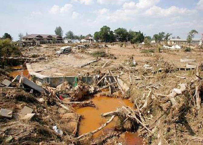
I. EXECUTIVE SUMMARY
Damaging tsunamis are rare but potentially catastrophic events that present a danger to the people and economy of
California. Over 80 tsunamis have been observed or recorded along the coast of California in the past 150 years, 9 causing
minor damage in ports and harbors and 2 with major impacts. Four events caused deaths; the worst occurred in 1964 when 12
people died in California from the tsunami generated by the Great Alaska earthquake. Local earthquakes can produce
damaging tsunamis that will provide very little warning time.

On Sunday, December 26, 2004, a strong earthquake of magnitude 9.3 occurred off the coast of northern Sumatra, triggering a
giant tsunami that propagated throughout the Indian Ocean Basin, causing massive casualties and destruction. As a result of
the Sumatra event and past damaging California tsunamis, the Seismic Safety Commission created a Tsunami Safety
Committee to evaluate the state of tsunami readiness in California. This committee held six meetings, took testimony from
representatives of local governments and the scientific community. Based on this testimony, the Seismic Safety Commission
made the following Findings and Recommendations:

Findings

1   Tsunamis, generated either locally or from events elsewhere in the Pacific Basin, pose a significant threat to life and
    property in California.

2   Tsunamis present a substantial risk to the economy of the State and Nation, primarily through the impact on our ports.

3   Californians are not adequately educated about tsunamis and the risk they pose;
    consequently, many are unaware how to respond to natural or official tsunami
    warnings.

4   The existing tsunami warning system has not achieved all of its objectives for
    several reasons including problems with communications, agency coordination
    and protocols.

5   Present building codes and guidelines do not adequately address the impacts of
    tsunamis on structures. Currently available tsunami inundation maps are not
    appropriate for code or guideline applications.

6   Federal programs have provided resources to initiate tsunami hazard mapping
    and mitigation programs. However, more effort and a better understanding of
    the risk is required to bring the treatment of tsunamis to a level comparable to
    other State hazards such as earthquakes.
                                                                                                                         .
7   The Governor’s Office of Emergency Services and many local governments have been proactive in addressing the State’s
    tsunami risk and, since the Sumatran tsunami and the June 14, 2005 tsunami warning in northern California, have
    renewed interest in improving warning dissemination and other aspects of tsunami planning and preparedness.

California Seismic Safety Commission                                                      The Tsunami Threat to California
                                                                1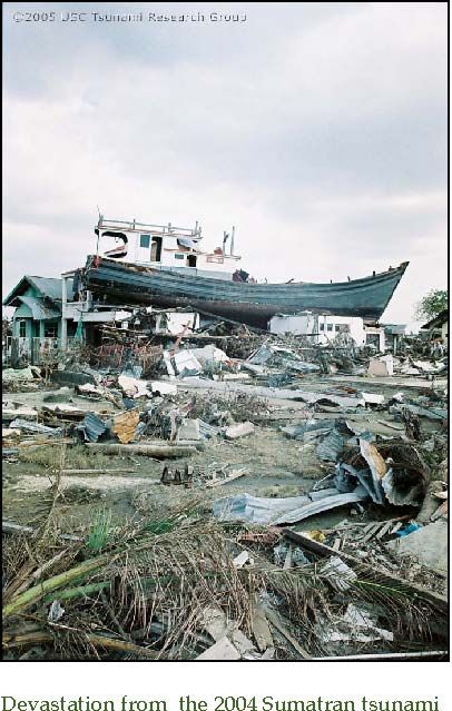
Recommendations
The State of California should:

1.   Improve education about tsunami issues in the State:

     a.   Include multi-language education about tsunami hazards and how to respond to large coastal earthquakes, sudden
          water level changes and official tsunami warnings in all California schools.

     b.   Actively educate coastal populations about tsunami hazard zones, evacuation routes and install signage consistent
          with other west coast states as soon as possible.

     c.   Update State and local earthquake preparedness materials to include tsunami safety. Incorporate tsunamis in safety
          training for workplaces in inundation zones, especially ports.

     d.   Develop multi-language tsunami information and educational materials and make them available to visitors to
          coastal areas.

2.    Work with other coastal states to obtain an external expert review of the NOAA tsunami warning system criteria for
     issuing and canceling warnings as well as the format and procedures for distribution.

3.    Continue to work with federal agencies to develop guidelines for structures to resist both strong ground motion and
     tsunami wave impact.

4.     Support and provide matching funds for tsunami mitigation programs in coastal counties and in OES, including
     improvements to the communications and emergency response systems. These funds will leverage federal support for
     tsunami mitigation programs.

5.     Support and provide matching funds for the development of improved technologies and methodology to assess the
     tsunami risk. These new technologies and risk assessments should be used to support better long-term and emergency
     response planning. Develop probabilistic tsunami hazard maps appropriate for building code and land-use regulations.

California Seismic Safety Commission                                                      The Tsunami Threat to California
                                                             2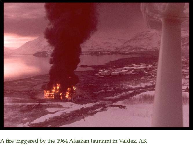
II. THE TSUNAMI HAZARD IN CALIFORNIA
What is a tsunami?
A tsunami is a series of waves most commonly caused by the deformation of the sea floor during a submarine earthquake.
They are also generated by landslides, volcanic eruptions or more rarely by asteroid impact. Tsunamis are extremely long
waves with the distance between successive peaks or troughs on the order of 10’s to 100’s of miles. As the waves enter shallow
water, they slow down and rise in height, in the largest cases, by
tens of feet. Large tsunamis can cause great loss of life and
property damage where they come ashore. Tsunamis are always
largest closest to the source region where they may strike the
closest coastlines only minutes after the triggering event. The
largest tsunamis travel across the ocean with sufficient energy to
cause damage thousands of miles away and many hours after
the source event occurred. When the coastal area is close to the
source region and the first waves to arrive take less than an hour
to travel, the tsunami is called a local or near‐field tsunami. For
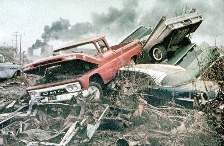
Crescent Beach Motel, Crescent City, California damaged by the 1964
travel times of several hours or longer, the tsunami is a distant or
tsunami. A core taken from the pond shown by the star. Deposits of
sand from the 1964 and 1960 tsunamis marked by the red arrows are far‐field tsunami.
much smaller than the 1700 deposit marked by the green arrow.
Does California have tsunamis?
California is at risk from both local and distant tsunamis. Eighty-two possible or confirmed tsunamis have been observed or
recorded in California during historic times. Most of these events were small and only detected by tide gages. Eleven were
large enough to cause damage and four events caused deaths. Two tsunami events caused major damage. The 1960 Chilean
earthquake produced a great tsunami that impacted the entire Pacific basin. Damage was reported in California ports and
harbors from San Diego to Crescent City and losses exceeded one
million dollars. The worst event was the 1964 tsunami generated
by the M 9.2 Alaska earthquake that killed 12 in Northern
California and caused over $15 million in damages. The peak
wave height was 21 feet in Crescent City and 29 city blocks were
inundated. Wave oscillations in San Francisco Bay lasted more
than 12 hours causing nearly $200,000 in damages to boats and
harbor structures.
What is the greatest risk to California?
The Cascadia subduction zone will produce the State’s largest
tsunami. The Cascadia subduction zone is similar to the Alaska-
Aleutian trench that generated the magnitude 9.2 1964 Alaska
earthquake and the Sunda trench in Indonesia that produced the
magnitude 9.3 December 2004 Sumatra earthquake. Native
American accounts of past Cascadia earthquakes suggest
tsunami wave heights on the order of 60 feet, comparable to
water levels in Aceh Province Indonesia. Water heights in Japan
produced by the 1700 Cascadia earthquake were over 15 feet,
comparable to tsunami heights observed on the African coast
after the Sumatra earthquake.
California Seismic Safety Commission The Tsunami Threat to California
3
The Cascadia subduction zone last ruptured January
26, 1700, creating a tsunami that left markers in the
geologic record from Humboldt County, California to
Vancouver Island, Canada and is noted in written
records in Japan. At least seven ruptures of the
Cascadia subduction zone are observed in the geologic
record.

Distant and local tsunamis.
Tsunamis that damaged California’s coast have come
from all around the Pacific basin including South
America and Alaska. Nearly two thirds of California’s
historic tsunami events and all but one damaging
event were generated by distant sources.
In addition, local tsunamis can be caused by offshore
                                                                      Comparison of the December 26, 2004 Sumatra rupture and the estimated
faults or coastal and submarine landslides and have the                    rupture of the 1700 Cascadia Subduction zone at the same scale.
                                                                                                Scale bar is 700 mi.
potential to cause locally greater wave heights and do
pose a threat to the state. The largest historic local-source tsunami on the west coast was caused by the 1927 Point Arguello,
California, earthquake that produced waves of about 7 feet in the nearby coastal area.

What government agencies are responsible?
The National Oceanic and Atmospheric Administration (NOAA) has
statutory   responsibility   to   provide   tsunami   warnings,       which     are
disseminated in California through the Governor’s Office of Emergency
Services. Local jurisdictions have the responsibility for ordering and
canceling evacuations.

The California Geological Survey has statutory authority to conduct tsunami inundation mapping, contingent on State
funding that has not yet been appropriated. The Governor’s Office of Emergency Services (OES) has contracted with the
University of Southern California for preliminary tsunami inundation mapping with funding from NOAA through the
National Tsunami Hazard Mitigation Program (Program). This Program supports tsunami hazard mitigation in the states of
California, Oregon, Washington, Alaska and Hawaii. The State of California has representation on the program steering
committee by a representative from the Governor’s Office of Emergency Services (OES) and a representative from the
California Geological Survey (CGS). Coordination with the other four western states and the National Tsunami Hazard
Mitigation Program is essential to the success of the Program.

California Seismic Safety Commission                                                                   The Tsunami Threat to California
                                                                  4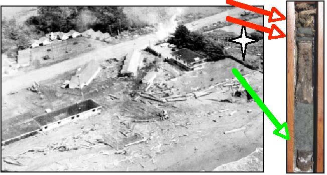
III. THE NATURE OF THE TSUNAMI RISK IN CALIFORNIA
Casualties.

As the 2004 Sumatran tsunami amply demonstrated, a large tsunami poses a major risk to human life, primarily from flooding
and debris impact. Evacuation is possible and can save many lives if carried out properly. However, a poorly coordinated
evacuation can actually put people in harm’s way. Moreover, the short time frame between event and tsunami for local events
requires that the local population be aware enough of the appropriate action to evacuate without official notification.

Of the five Pacific states, California has the largest population exposed to tsunami risk. NOAA has estimated that more than
one million people in California live within coastal areas vulnerable to tsunami inundation (the rushing in of the water
causing flooding and battering by debris). That number does not include one million or more visitors to California’s beaches
on any given summer day.

Financial losses.
Tsunamis cause damage to man-made structures in several ways, primarily from water currents and the impact of water-
borne debris. The incoming waves cause flooding and push vessels into land-based structures. The withdrawing waves causes
vessels and boats to hit bottom and damages power plants and other facilities that use sea water for cooling. The strong
currents scour foundation material from under structures and carry debris. Debris carried by the water batters people and
property, and is responsible for much of the damage from tsunamis. Secondary effects, such as fire and the release of
hazardous materials, can escalate the disaster to a greater catastrophe. These effects are difficult to predict.

The exposure of our built environment to possible tsunami damage varies dramatically along the California coast. The
flooding produced by the tsunamis depends strongly on local topography. Some areas, such as Crescent City, California have
experienced large run-up, whereas other areas have yielded relatively minor impacts. In general, lower areas have always
been more vulnerable. The codes that produce buildings resistant to earthquakes do not, in general, address the forces likely
to arise from tsunamis. Many structures are designed to resist forces directed towards the structure; however, once water
enters the structure and draw-down occurs outside of the structure, walls may collapse or deflect outward, causing serious
damage.

                                 Aerial photographs of Banda Aceh, Indonesia, before and after the 2004 tsunami.
Seaports.
Our ports face the greatest exposure for catastrophic losses. The Ports of Los Angeles and Long Beach are the first and second
busiest seaports in all the United States. Together these California State-owned but city-managed seaport complexes handle 14
million units of containers annually, which make them the third busiest port in the world. Combined they handle
approximately $240 billion worth and 250 million metric tons of cargo, generate $10 billion worth of yearly taxes, and are
responsible for approximately $100 billion in direct and indirect business annual sales, and directly and indirectly generate

California Seismic Safety Commission                                                                        The Tsunami Threat to California
                                                                       5
some 600,000 and 2.5 million jobs throughout our State and nation, respectively. Other economically important ports in
California subject to tsunami damage include those in Oakland, Richmond and San Diego.

There is substantial development of apparently well engineered and “permanent” port infrastructure designed only for
earthquake forces. They are located largely along the water’s edge at the two ports and include the pile supported reinforced
concrete wharves, rubble mound retaining structures, and ship-to-shore
container cranes. There are also a multitude of potentially loose
infrastructure and objects that can become buoyant and/or free floating in
the event of flooding from a significant tsunami. These include the millions
of tons of open stored dry and break bulk products; mobile equipment,
vehicles, railroad infrastructure and tools; approximately 10,000 8,400
pound empty 40-foot containers; about 60 huge simultaneously berthed
ocean-going ships; and thousands of smaller pleasure craft and harbor boats. These vessels are secured to their docks by sets
of mooring lines that provide security for “normal” ship mooring forces, and not for the tremendous vertical buoyant and
hydrodynamic forces that can be induced by major tsunamis.

The ports’ docks and terminals operate at a surface level that is, in general, only 9 feet above the mean high seawater level. A
15‐foot (or greater) tsunami, for example, arriving at the Inner Harbor would therefore overtop the wharf decks and inundate
                                                                    much of the 7500‐acre landside port operations. Without
                                                                    adequate warning, this would cause considerable human
                                                                    casualties, operational disruption, port damage, and economic
                                                                    impact. Based on the ports’ own data, a two‐month shut down
                                                                    of the two ports would result in a overall total economic loss of
                                                                    $60 billion. In addition to this, there are approximately 8,000
                                                                    total outdoor personnel on any given port operational day.
                                                                    Unless safely evacuated, these workers can face injury and loss
                                                                    of life directly from drowning, or indirectly by water borne
                                                                    collision into water‐borne debris.

      The port of Valdez, AK after the tsunami of March 27, 1964.

California Seismic Safety Commission                                                             The Tsunami Threat to California
                                                                    6
IV. TWO CASE STUDIES

The devastating Sumatran tsunami of December 26, 2004 and the American tsunami alert of June 14, 2005 each provide insight
for where we can improve safety in California.

Sumatra, Indonesia.
The 2004 great Sumatran earthquake occurred on a fault that extends over 1200 kilometers (800 miles) off the coast northern
Sumatra. The earthquake triggered a giant tsunami that propagated throughout the Indian Ocean Basin, causing massive
casualties, extreme inundation, and destruction along the northern and western coast of Sumatra. Within hours, the tsunami
devastated the shores of Thailand to the east as well as Sri Lanka, India and the Maldives to the west. The tsunami also caused
deaths and destruction in Somalia and other nations of east Africa. The propagation of the tsunami was worldwide so that it
was even detected on the California coast.

                                                                   One of the strongest lessons learned from the Sumatran tsunami is
                                                                   the power of public education and tsunami awareness. At Jantang,
                                                                   an entire town was destroyed when tsunami waves surged in over
                                                                   15 m (45 feet). Ninety percent of the villagers were killed and 100%
                                                                   of the structures were destroyed.

                                                                   In Langi village on the island of Simeulue, the tsunami wave was
                                                                   slightly smaller, but only by a few feet. The surge still destroyed
                                                                   100% of the town’s buildings, yet no one was killed. The difference
                                                                   was the level of tsunami awareness of each community. The people
                                                                   of Langi maintain a strong oral tradition and frequently recount
                                                                   stories of past tsunami disasters to the younger members of the
       Damage at a tourist beach from the 2004 Sumatran tsunami.   community. The oral history recounted the events of 1812 when a
                                                                   similar tsunami had devastated the area. The people had even
                                                                   prepared gathering points and evacuation routes in anticipation of
                                                                   another tsunami.

A second lesson is that you don’t have to live on the coast to be at risk from a tsunami. The Sumatran tsunami was the
deadliest natural disaster in the history of Sweden, killing 551 vacationing Swedes in Thailand and Sri Lanka. Anyone who
visits the beach is at risk from tsunamis.

June 14th alert in California.
On June 14, 2005 a magnitude 7.2 earthquake occurred offshore of Northern California, in the vicinity of the Cascadia
Subduction Zone. Following procedures, the NOAA Tsunami Warning Center issued a tsunami warning 6 minutes after the
event for the whole west coast from San Diego to British Columbia. The
earthquake generated a small tsunami, which was only detected on tidal
gauges and on one of NOAA’s Deep Ocean Assessment and Reporting of
Tsunamis (DART) buoys and caused no damage. The warning was canceled
78 minutes after the event. This event intensified interest in the tsunami
                                                                                                                 .
threat to California and identified several gaps in tsunami preparedness
and response capability that could pose potentially serious problems. These include the basis for NOAA issuing and canceling
warnings, inadequate alert and warning systems at the local, state and federal government levels, a general lack of knowledge
of the tsunami threat, needs for public information materials, and jurisdictions without tsunami response plans and
procedures.

California Seismic Safety Commission                                                                   The Tsunami Threat to California
                                                                      7
NOAA through the National Weather Service operates two Tsunami Warning Centers, one located in Hawaii (PTWC) and the
other in Palmer, Alaska. The West Coast Alaska Tsunami Warning Center in Palmer (WCATWC) is responsible for issuing
warnings, watches and tsunami information messages to all regions along the west coast of the United States including
California. The Center receives seismic information from a variety of networks coordinated by the US Geological Survey.

The warning was issued by the Alaska center on the basis of internal procedures that call for a warning to all areas within two
hours travel time of an earthquake above magnitude 7 off the coast. Many scientists expressed skepticism that the wide spatial
coverage of the warning was appropriate in that a tsunami still large enough to be damaging hundreds of miles from the
source seemed extremely improbable. The Hawaii center issued a bulletin saying no warning was in effect, because the
Hawaii center has responsibility to warn the western Pacific. Some recipients of both messages misinterpreted the Hawaii
statement as a cancellation of the Alaskan warning. The warning was canceled, again as specified in the procedures, when the
predicted wave recorded on a DART buoy was too small to be damaging. Eleven minutes after the earthquake, seismological
data had shown that the earthquake did not result from vertical deformation of the sea floor and was located 30 km west of
the Cascadia subduction zone, greatly reducing the likelihood that a tsunami had been generated. NOAA procedures do not
use seismological information for canceling warnings.

The California State Warning Center (CSWC) received the warning. The
tsunami warning issued by NOAA contained language and format that was
unclear or obscured critical information. The CSWS disseminated the
warning through the California Warning System (CALWS), the California
Law Enforcement Teletype System (CLETS) and the Emergency Digital
Information System (EDIS). Not all affected local jurisdictions were aware
of the warning from the CSWC. Many who did receive it had difficulty
interpreting its impact. The response by local counties varied significantly
from evacuations to no response. Some jurisdictions experienced difficulty
in ramping up staffing levels that were required for effective notification,
activations of emergency operation centers and situation assessment.

This tsunami warning also generated requests from most of the Coastal Counties for training workshops and technical
assistance in developing procedures and response plans that cannot be met with current staff resources. Since that time,
CSWC staff has reviewed and been re-trained on the tsunami standard operating procedure. CSWC is currently upgrading its
automated call system (Dialogic). The upgraded system will be capable of 1,000 one-minute or 2,000 thirty-second calls in 21
minutes. OES conducted a Tsunami Summit on July 19, 2005 with the coastal counties to review state and local procedures
and the use of warning communication technologies. The National Weather Service conducted a successful test of the national
tsunami system on September 14, 2005, relaying text messages to the coastal cities and the Coast Guard.

California Seismic Safety Commission                                                        The Tsunami Threat to California
                                                              8
V. REDUCING THE RISK
Losses from tsunamis can be reduced in four ways. First, engineering standards can create buildings and port structures more
resistant to the damage. Second, public education can train Californians to recognize natural and official tsunami alerts and
provide basic instruction as to what to do. Third, warning systems can alert a population to a tsunami coming from a distant
source. Fourth, effective evacuation planning can reduce casualties by getting people out of harm’s way. On all four fronts,
progress has been made and more could be done to increase tsunami safety.

Engineering.
U.S. Building codes generally have not addressed the subject of designing structures in tsunami zones. FEMA’s Coastal
Construction Manual (FEMA 55), developed to provide design and construction guidance for structures built in coastal areas,
addresses seismic loads for coastal structures and provides information on tsunami and associated loads. However, the
authors of the Coastal Construction Manual concluded that tsunami loads are far too great and that, in general, it is not
feasible or practical to design “normal” structures to withstand these loads. It was acknowledged that special design and
construction details would be possible for critical facilities.

                                                                         In contrast, the National Tsunami Hazard Mitigation Program
                                                                         Background Paper #5: Building Design written for the
                                                                         publication Designing for Tsunamis concludes that “good design
                                                                         and engineering can greatly minimize the [destructive] effects
                                                                         of tsunamis on buildings.” It points out that the City and
                                                                         County of Honolulu has adopted special requirements for
                                                                         floods and tsunamis such as “Article 11, Regulations within
                                                                         Flood Hazard Districts…” which includes a provision
                                                                         addressing tsunami loads, among other special loading
                                                                         requirements. These loading requirements are in some
                                                                         instances at variance with those in the Coastal Construction
                                                                         Manual.
      A fire triggered by the 1964 Alaskan tsunami in Valdez, AK.

The initial phase of an ongoing FEMA/NOAA program regarding tsunamis and their potential forces on structures has just
been completed. The second phase will concentrate on construction design guidance for tsunami shelter structures (to allow
for vertical evacuation) and is being done under contract to the Applied Technology Council. It is thought that the criteria for
tsunami shelters could be applied to essential emergency facilities and to structures with large occupancies, such as large
seaside resorts.

One conclusion is that, although other states such as Washington and
Oregon and local jurisdictions are moving toward developing load and
resistance code requirements applicable to general building construction in
tsunami zones, considerably more effort, both in re-search related to and
development        and     limitation      of    such     provisions,   is   required.

California Seismic Safety Commission                                                                The Tsunami Threat to California
                                                                        9
The current inundation maps are estimates of the worst possible tsunami scenario. Knowing only the maximum possible run-
up without information about probability of occurrence is insufficient to set engineering guidelines. Probabilistic standards,
such as those used for earthquakes, are needed for many planning applications and to prioritize resources.
Education.
Tsunami safety depends first and foremost on personal action. People who move quickly from the inundation zone move
themselves to safety. Whether in response to feeling an earthquake or receiving a warning, safety comes from the personal
decision to take appropriate action and thus depends on every citizen possibly at risk knowing how to respond appropriately.
This knowledge must be conveyed to all our citizens for true safety to be achieved.
The first step in education begins in schools. At present, public schools
have no tsunami or earthquake safety curriculum. All California schools
should teach the basic elements of earthquake and tsunami safety to all
children. Earthquakes can strike anywhere in the State and anyone
could visit the beach. This should include:
• What to expect during an earthquake and how to respond
appropriately;
• How to respond to an earthquake near the ocean or a tsunami
warning;
• Basic causes of earthquakes and tsunamis;
• Likely sources of earthquakes and tsunamis that could affect
California;
A scientist explaining tsunami waves to high school • What makes a building earthquake safe.
students.
Because of the 2004 Sumatran event, tsunami safety information has been
added to some of the public information materials about earthquakes, such as
the Homeowner’s Guide to Earthquake Safety (produced by the California
Seismic Safety Commission) but there has been no organized effort to ensure
our citizens receive the information they need. California should also provide
tsunami preparedness information for the general public organized along the
lines of the Emergency Survival Program and other emergency preparedness community outreach programs. This should
include:
• Program Information Sources available to the public that would outline tsunami threat in California as well as
outline the alert and warning procedures used by state and local government for tsunamis.
• Local threat information such as tsunami inundation maps, evacuation routes and safe refuge locations.
• Tsunami hazard information and emergency preparedness tips presented using radio and television, printed
handouts, Internet and telephone directories.
Evacuations Plans.
Effective evacuation planning depends on accurate and meaningful tsunami inundation (flooding) and hazard maps. Under
the National Tsunami Hazard Mitigation Program, California has received funding to prepare preliminary Tsunami
Inundation Maps for the entire state of California. The State Office of Emergency Services, working with the University of
Southern California, has produced inundation maps for most of the coast, which represent the maximum projections for
California Seismic Safety Commission The Tsunami Threat to California
10tsunami inundation. The California Legislature has authorized the California Geological Survey to prepare tsunami hazard
maps but has never allocated funding for the task.
Only some communities have completed actual evacuation plans based on these maps. Even fewer have begun the process of
educating their residents how to respond and posting signs for evacuation routes. The primary impediment has been the lack
of funding for this effort. In addition, the evacuation plans must be created by local government emergency managers. These
are the same people who prepare for terrorist incidents and they have often been diverted onto other tasks in the last few
years.
Because these maps represent the maximum inundation expected from the largest tsunamis, using these inundation areas for
the more common smaller events can cause problems. The computer infrastructure and modeling systems are in place to
produce more detailed tsunami inundation that would give emergency planners better information to work with when
making a decision on evacuation.
California needs a more consistent effort toward tsunami mitigation in all coastal areas, with resources to support these
efforts. The State can support standardization, developing guidance materials that identify a “standard of care” for tsunami
response to include maps, directions and conditions for safely evacuating inundation zones. The State should also support
development and distribution of standardized public education materials, signage and training for tsunami planning. After
many years of uncertainty about tsunami signage because of conflicting
objectives between responsible agencies, Caltrans has issued an official
notification that local agencies in California may begin installing Tsunami
Signs in tsunami inundation areas as defined by the National Oceanic and
Atmospheric Agency (NOAA).
Tsunami warning system.
The tsunami warning system in the Pacific Basin is operated federally under
NOAA as part of a Pacific Basin system and is not the direct responsibility
of California. A significant upgrade to the system is underway with new
federal funding approved after the Sumatran tsunami. Tsunami warnings are issued by the center in Palmer, Alaska for the
West Coast of the United States and by the Hawaii center for Hawaii and the western Pacific Basin. In some cases, such as the
June 14, 2005 Gorda plate event, bulletins issued by the two warning centers may appear contradictory as they are intended
for different areas of responsibility. Subsequent bulletins are issued hourly by the Tsunami Warning Centers as water level
heights from the DART Buoy network and tide gauges close to the source area become available until the event is ultimately
cancelled. If the tide gauges show no unusual wave activity, a bulletin is issued canceling the tsunami warning, watch or
advisory. Tsunami bulletins are transmitted to local public agencies that make the decision to evacuate coastal areas if local
authorities deem it necessary. The tsunami warning system is only effective if local populations cooperate with authorities and
wait for an official “all-clear” before returning to the evacuation zone.
The national tsunami warning system was developed decades ago, in response to a major tsunami in 1946. The criteria for
issuing watches, warnings and bulletins are decided internally by NOAA. NOAA issues the warnings and leaves to local
communities the decision of how to respond. A significant deficiency is an inability to cancel an alert quickly if further
evidence suggests that it is not appropriate. In June 2005, significant financial costs were incurred and the potential for injury
was increased because the alert was continued for an hour after most scientists recognized that a potentially damaging
tsunami was not underway. Local jurisdictions also need help in understanding whether evacuation is appropriate in a
particular situation.
The State of California should encourage the federal government to continue to support and develop the tsunami warning
system. The State should work with the other states on the Cascadia Subduction Zone to ensure our needs are being heard and
met. Distribution to local jurisdictions is handled through several communication systems. Improvements to these systems
California Seismic Safety Commission The Tsunami Threat to California
11have begun because of the lessons learned from the June 2005 tsunami warning and should be supported by the State. The inundation maps available to local emergency responders were not suited for the type of event experienced on June 14, 2005. If an evacuation order for the populated areas of southern California had been given for this event, millions of people would have been put into the potentially harmful situation of a mass evacuation. It is clear that a worst case scenario inundation map for an extreme local tsunami in southern California is not appropriate for a warning induced by a moderate earthquake in northern California. False Alarms. An evacuation based on a false alarm can cost lives in addition to incurring unnecessary expenses in personnel time and a depletion of other resources. An evacuation has its risks and should not be undertaken lightly. The recent, sad case of the elderly patients in Houston who died in a bus fire while being evacuated from Hurricane Rita is a vivid example. At present, the NOAA warning system issues a warning whenever a tsunami occurs, even if the impact would be inconsequential.. For instance, the warning on June 14, 2005 was issued for the entire coast of the western U.S., even though no damage from a tsunami generated by a M
VI. SEISMIC SAFETY COMMISSION RECOMMENDATIONS

Recommendation 1: The State of California should improve education about tsunami issues in the State, by:

    a.   Include multi-language education about tsunami hazards and how to respond to large coastal earthquakes, sudden
         water level changes and official tsunami warnings in all California schools.

    b.   Actively educate coastal populations about tsunami hazard zones, evacuation routes and install signage consistent
         with other west coast states as soon as possible.

    c.   Update State and local earthquake preparedness materials to include tsunami safety. Incorporate tsunamis in safety
         training for workplaces in inundation zones, especially ports.

    d.   Develop multi-language tsunami information and educational materials and make them available to visitors to
         coastal areas.

Justification. Technological improvements in detection, hazard assessment and warning dissemination are of little use if the
people do not understand the information. While tens of thousands of Indonesians died in the 2004 tsunami, every one of the
800 residents of Langi survived the complete destruction of their village because they knew to evacuate to higher ground.
Education is the foundation of all the safety plans.

Recommendation 2: Work with other coastal states to obtain an external expert review of the NOAA tsunami warning
system criteria for issuing and canceling warnings as well as the format and procedures for distribution.

Justification: The present warning system leads to significant costs to the states through false alarms and delays in
cancellation. The local jurisdictions are forced to evaluate tsunami risk to decide on appropriate actions with insufficient
information or knowledge base. The concerns of the states need to be included in the process of developing the warning
system.

Recommendation 3: Continue to work with federal agencies to develop guidelines for structures to resist both strong
ground motion and tsunami wave impact.

Justification. The financial losses in the seaports could have a major impact on the economy of the United States. Investment
in better structures when they are built could lead to significant savings in the long run. Earthquake risk is large in California
so tsunami engineering must also take strong ground motions into account.

Recommendation 4: Support and provide matching funds for tsunami mitigation programs in coastal counties and in OES,
including improvements to the communications and emergency response systems. These funds will leverage federal
support for tsunami mitigation programs.

Justification. The events of June 14, 2005, showed us that not all of California is ready to respond to the tsunami warnings that
we will be receiving. It is important that all responding agencies at both the local and state level have had the opportunity to
work together before the event.

Recommendation 5: Support and provide matching funds for the development of improved technologies and methodology
to assess the tsunami risk. These new technologies and risk assessments should be used to support better long-term and
emergency response planning. Develop probabilistic tsunami hazard maps appropriate for building code and land-use
regulations.

Justification. The level of understanding of the tsunami risk is significantly less complete than we have for other hazards such
as earthquakes. The long-term losses expected from tsunamis can be significantly reduced through application of our
knowledge.

California Seismic Safety Commission                                                          The Tsunami Threat to California
                                                              13
California Seismic Safety Commission
1755 Creekside Oaks Drive, #100
Sacramento, California 95833
(916) 263-5506
Lawrence T. Klein, Chair Andrew A. Adelman Hon. Richard Alarcon
Utility Planning Cities/Building Official Alternate: Chris Modrzejewski
State Senate
Mark Church Dr. Bruce R. Clark Dr. Lucile M. Jones
Local Government Geology Seismology
Hon. Carol Liu Gary McGavin Celestine Palmer
Alternate: Don Manning Architecture Planning Insurance
State Assembly
Jeff Sedivec Daniel Shapiro Keith Wheeler
Fire Protection Structural Engineering Social Services
Dr. Dennis Mileti Dr. Arul Arulmoli
Social Services Soils Engineer
Tsunami Safety Ad Hoc Committee
Donald Parker, Chairman Commissioner Jones Commissioner Shapiro
Fire Chief, City of Vallejo Seismology Structural Engineer
Dr. Jose Borrero Dr. Lori Dengler Rich Eisner
Tsunami Research Center Redwood Coast Tsunami Wk. Gp. Chief, Coastal Region
University of Southern California Humboldt State University State Office of Emergency Services
Orville Magoon Dr. Michael Reichle Crystal Rockwood
President Chief Seismologist Communications Director
Coastal Zone Foundation California Geologic Survey Pillsbury Winthrop Shaw Pittman, LLP
Jeff Terry Linden Nishinaga Richard McCarthy
Program Specialist Senior Civil Engineer Executive Director
LA County Emergency Management City of Long Beach CSSC
Henry Reyes Robert Anderson James Lee
Project Manager Geologist Intern
CSSC CSSC CSSC
Veronica Ramirez
Intern
CSSC
California Seismic Safety Commission The Tsunami Threat to California
14Testimony Gratefully Received from
Lloyd Cluff Mark Johnsson George Meis
Director, Geosciences Department Staff Geologist Chief, Office of Signs, Marking
PG&E Calif. Coastal Commission & Permits, Caltrans
Doug Sandy David Dystra Martin Eskijian, P.E.
Emergency Planner Senior Coastal Engineer Senior Engineer
City of San Francisco OES Moffat & Nichol State Lands Commission
Linden Nishinaga, Committee Member Dr. Fred Raichlen Dr. Dick Seymour
Senior Civil Engineer Engineering Professor Head, Ocean Research Group
City of Long Beach Caltech Scripps Institute
Jeff Terry, Committee Member Dan Larkin Allen Winogradov
Program Specialist Program Coordinator Program Coordinator
LA County Emergency Management Humboldt County OES Del Norte County OES
California Seismic Safety Commission Staff
Richard J. McCarthy Sue Celli Karen Cogan
Executive Director Robert Anderson Henry Reyes
Fred Turner Henry Sepulveda
James Lee Veronica Ramirez
Appendix A
Support material used in the creation of this report is available at: http://www.seismic.ca.gov/Appendix_A_Tsunami_Report.htm
California Seismic Safety Commission The Tsunami Threat to California
15You can also read