2021 Tamarisk and Russian-olive Aerial Survey Information
←
→
Page content transcription
If your browser does not render page correctly, please read the page content below

2021 Tamarisk and Russian-olive
Aerial Survey Information
Methodology Summary
On July 7-8, 2021, a US Fish and Wildlife survey plane (Quest Kodiak) was flown at
approximately 500-700’ AGL (above ground level) over the river courses of interest at
approximately 80-100 knots. One USDA Forest Service employee mapped Russian-olive,
and one Kansas Forest Service employee mapped tamarisk.

Areas with the plant of interest were recorded by drawing either a polygon (of at least 1 acre) or recording an individual
point, using tablets equipped with the Digital Mobile Sketch Mapping (DMSM) software. For polygons, density data was
recorded according to the best estimates of the surveyor.

Notes: A distinction needs to be made between acreage WITH tamarisk, and acreage OF tamarisk. This project mapped
areas that had apparent infestations of tamarisk present; or acres WITH tamarisk. Acres OF tamarisk can only be
determined when the only vegetation present is tamarisk, or by reducing the acres mapped according to the density
(100 acres WITH tamarisk at 50% density = 50 acres OF tamarisk), however this runs the risk of multiplying error. Data
from this survey should be characterized as acres “with tamarisk.”

For some areas surveyed, tamarisk polygons could not be created due to extrememly sparse densities, or due to heavy
overstory cover. This resulted in an underestimate of tamarisk along the South Fork of the Republican River (SFRR)
where this survey recorded 0 acres, although tamarisk is known to exist from previous ground survey information. This
also likely resulted in an underestimate of tamarisk along the eastern stretches of the Smoky Hill due to hardwood tree
cover along the river. Estimates of Russian-olive, a larger tree, did not suffer these same complications.

        Photo above is typical view from plane, with tamarisk clearly visible along center of Arkansas channel.
Photo above shows Russian-olive along the Arikaree in Cheyenne County.

Below, preliminary Russian-olive (green) and tamarisk (red) data from Cheyenne County.
Survey Bounds
•   Arikaree: CO-KS state line to KS-NE state line; covered Cheyenne county
•   South Fork Republican River: CO-KS state line to KS-NE state line; covered Cheyenne county
•   Smoky Hill: confluence of forks of Smoky Hill west of Russell Springs to east of Hwy 281 south of Russell;
    covered Logan, Gove, Trego, and Ellis counties
•   Arkansas: CO-KS state line to northeastern bend near Ford/Kiowa county lines; Hamiton, covered Kearny,
    Finney, and Ford counties
•   Cimarron: CO-KS state line to KS-OK state line south of Meade, also KS-OK state line to KS-OK state line south in
    Clark and Comanche counties; covered Morton, Stevens, Seward, Meade, Clark and Comanche counties.
County Summaries (Acres WITH)
County River Russian-olive Tamarisk
Cheyenne Arikaree 97 14
Cheyenne SFRR 1720 0*
Logan Smoky Hill 426 0*
Gove Smoky Hill 102 41
Trego Smoky Hill 518 538
Ellis Smoky Hill 124 5
Hamilton Arkansas 203 5270
Kearny Arkansas 34 2845
Finney Arkansas 0* 1700
Ford Arkansas 7 320
Morton Cimarron 0* 2576
Stevens Cimarron 0* 249
Seward Cimarron 632 1236
Meade Cimarron 254 2496
Clark Cimarron 0* 3413
Comanche Cimarron 0* 292
*zero acres does not necessarily indicate absence of this species
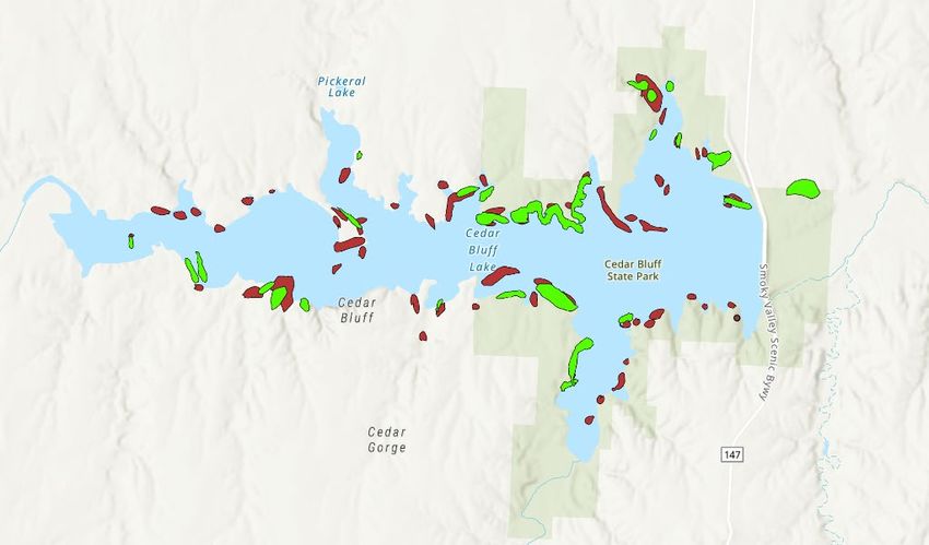
A significant portion of the tamarisk and Russian-olive mapped in Trego County was found immediately surrounding
Cedar Bluff Reservoir, as seen in the preliminary polygon data below.Comparison to 2004 Tamarisk Survey
In 2004, a helicopter survey was conducted by Kansas Department of Agriculture staff. Due to varying methodologies
between the 2004 and the 2021 surveys, they should not be directly compared to determine trends. However, they both
show that relative to other counties/areas surveyed that same year, the highest concentrations of tamarisk are in Clark,
Finney, Hamilton, Kearny, Meade, Morton and Seward counties. The exceptions are in Comanche and Ford counties,
where the 2004 survey indicated relatively high levels of infestation, but the 2021 survey did not find these densities of
tamarisk. This could be due to survey technique differences, or successful projects that have removed tamarisk in these
areas.
County 2004 2021 County 2004 2021
Clark 9389 3413 Barber 1513 x
Comanche 3550 292 Barton 58 x
Finney 1804 1700 Cheyenne x 14
Ford 1798 320 Cowley 1 x
Hamilton 5606 5270 Edwards 989 x
Kearny 3644 2845 Ellis x 5
Meade 4104 2496 Gove x 41
Morton 5732 2576 Grant 300 x
Seward 3642 1236 Gray 960 x
Stevens 553 249 Logan x 0
Pawnee 492 x
Reno 1376 x
Rice 628 x
Sumner 1 x
Trego x 538
Data Usage
It is important to use the data generated from this survey appropriately. Due to the nature of how it was gathered, the
data is not necessarily accurate at a very fine scale along the rivers – polygon borders are not exact. However, it can be
used to indicate relative intensities and locations of infestations and can guide outreach and project work on a County or
sub-County level.
County maps have been created and will be made available to local partners and the public. Shapefiles and other GIS
data can be made available upon request.
These maps should NOT be shared without also providing the information contained in this document, to avoid errors in
interpretation or inappropriate usage of this data.
Any questions or requests should be directed to the Kansas Forest Service contacts below:
Ryan Armbrust Darci Paull
Forest Health Coordinator GIS Specialist
rarmbrust@ksu.edu dpaull@ksu.edu
Acknowledgements
This project could not have taken place without support and assistance from the following partners: Brian Howell and
Marianne Davenport, USDA Forest Service; Phil Thorpe and Aron Flanders, US Fish and Wildlife Service; Kevin Klag and
Kurtis Meier, Kansas Dept. of Wildlife and Parks; Jeff Vogel and Scott Marsh, Kansas Dept. of Agriculture; and others.Logan County
§
¨
¦
70
U
V
25
§
¨
¦ 70
Oakley
£
¤ 40
Winona £
¤ 40
Russell
Springs
U
V25 Sm
oky
£
¤
83
H ill River
Lake Scott
State Park
U
V95
Transportation System Russian Olive
Primary Limited Acess or Inerstate Reservoir
Primary US and State Highways River
Secondary State and County Highways Incorporated Areas
Local, Neighborhood, Rural or City Street County
4WD 0 1 2 4
On/Off Ramp MilesYou can also read