A CRITIQUE ON THE NON-SCIENTIFIC CONSTRUCTION OF KEDARNATH AND POST DISASTER RECOVERY AFTER FLASH FLOODS 2013 - IJCRT
←
→
Page content transcription
If your browser does not render page correctly, please read the page content below
www.ijcrt.org                                             © 2021 IJCRT | Volume 9, Issue 3 March 2021 | ISSN: 2320-2882

    A CRITIQUE ON THE NON- SCIENTIFIC
    CONSTRUCTION OF KEDARNATH AND
  POST DISASTER RECOVERY AFTER FLASH
               FLOODS 2013
                                                            1
                                                            Anas Ahmed
                                                                1
                                                              Architect
                                                    1
                                                     Architecture & Construction
                                                         1
                                                           New Delhi, India

Abstract: Kedarnath, one of the twelve Jyotirlings, is an important Hindu pilgrimage. Kedarnath temple is believed to have been
constructed in the 8th century. On 16 June 2013, the Uttarakhand State suffered a mega-disaster. The entire State was hit by very
heavy rainfall and flash floods and among the 13 districts Bageshwar, Chamoli, Pithoragarh, Rudraprayag and Uttarkashi were the
worst affected witnessing huge loss of lives, property and infrastructure. The reason for the destruction was claimed to be natural
but it was evident that its non-scientific construction is equally responsible for the disaster. This paper aims at revealing the causes
of the disaster and the recovery done by the government during and post-disaster.

Index Terms – Vulnerability Assessment, Torrential Rain, Westerlies, Glacial Lake Outburst Flood, Disaster Recovery and
Reconstruction, Ecology

1. Introduction

India, with its unique geophysical setting and socio-economic conditions is highly vulnerable to disasters. The country is prone to
disasters due to number of factors, both natural and human induced, including adverse geo-climatic conditions, topographic features,
environmental degradation, population growth, urbanization, industrialization, flawed development practices, etc. As far as the
geographic dimensions of the country are concerned, the five distinctive regions of the country i.e. Himalayan region, the alluvial
plains, the hilly part of the peninsula, and the coastal zone have their own specific problems. While on one hand the Himalayan
region is prone to disasters like earthquakes and landslides, the plain is affected by floods almost every year. The desert part of the
country is affected by droughts while the coastal zone is susceptible to cyclones and storms. If we analyze the layers of vulnerability
statistically, out of 35 States and Union Territories in the country, 27 of them are disaster prone. [1]

                                                  Fig 1. Damage due to Disasters

     IJCRT2103300           International Journal of Creative Research Thoughts (IJCRT) www.ijcrt.org                       2401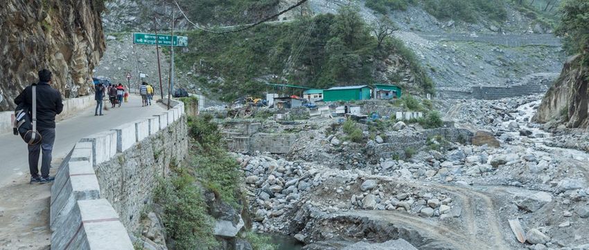
www.ijcrt.org © 2021 IJCRT | Volume 9, Issue 3 March 2021 | ISSN: 2320-2882
1.1 Vulnerability profile of India:
India is vulnerable in varying degrees to a large number of natural as well as man-made disasters.
Over 40 million hectares (12 per cent of land) is prone to floods and river erosion.
58.6 per cent of the landmass is prone to earthquakes of moderate to very high intensity
Of the 7,516 km long coastline, close to 5,700 km is prone to cyclones and tsunamis.
68 per cent of the cultivable area is vulnerable to drought and hilly areas are at risk from landslides and avalanches.
Further, the vulnerability to Nuclear, Biological and Chemical (NBC) disasters and terrorism has also increased in the past
years. [2]
Vulnerability profile of India
Landslides
3%
Cyclones
8%
Floods Earthquake
12% Droughts
Floods
Droughts Earthquake Cyclones
9% 58% Landslides
Fig 2. Vulnerability profile of India (NIDM)
1.2 Major disasters in India in the past two decades:
Natural disasters are events of the Nature which cause sudden disruptions to the normal life of the community. It
eventually cause damage to the lives and property to such an extent that normal social and economic mechanism that are
locally available to the community become inadequate to restore normalcy. About 80% of India’s land often faces natural
Disasters like earthquakes, landslides, floods, cyclones, drought, lightening, avalanche, summer dust storms, hail storms
Forest fires, coastal erosion etc. India ranks 4th in the list of countries that were most hit by natural disasters in the year
2006. A large number of manmade disasters such as biological (pest attack, epidemics etc.); industrial and technological;
Environmental (air, water and land pollution); fire, road and railway accidents etc, are also cause severe setbacks to the
Community. [3]
Table 1. Major disasters in India in the past two decades [4]
Region Cause Deaths
Kashmir Floods Disaster, 2014 Continuous torrential rainfall and swelling of 550+
Jhelum River
Uttarakhand Flash Floods, 2013 Heavy rainfall, massive Landslides 5700+
Bihar Flood disaster, 2007 Heavy rainfall 1287+
The Indian Ocean Tsunami 2004 Tsunami 230000+
Mumbai Catastrophe 2005 Rainfall 5000+
Indian Heat Wave 2002 Intense Heat Wave 1000+
Gujarat Earthquake, 2001 Earthquake 20000+
Super Cyclone, Odisha, 1999 Cyclone 15000+
IJCRT2103300 International Journal of Creative Research Thoughts (IJCRT) www.ijcrt.org 2402
www.ijcrt.org                                           © 2021 IJCRT | Volume 9, Issue 3 March 2021 | ISSN: 2320-2882
2.1 Kedarnath flash floods: The Disaster

In June 2013, a mid-day cloudburst centered on the North Indian state of Uttrakhand caused devastating floods and landslides,
becoming the country's worst natural disaster since the 2004 tsunami. The rainfall received that month was far greater than the
rainfall the state usually received. Debris blocked the rivers, causing major overflow. [5]
Though all the thirteen districts of the State were hit, five districts, namely Bageshwar, Chamoli, Pithoragarh, Rudraprayag and
Uttarkashi were the worst affected. The disaster coincided with the peak tourist and pilgrimage season, significantly enhancing the
number of the casualties and adversely affecting the rescue and relief operations. The impact of disaster was most pronounced in
the Mandakini valley of the Rudraprayag district. Torrential rains, coupled with the probable collapse of the Chorabari Lake, led to
flooding at the Kedarnath Shrine and the adjacent areas of Rambara, Agastyamuni, Tilwara, and Guptkashi. Other pilgrimage
centers in the region, including Gangotri, Yamunotri and Badrinath, which are visited by thousands of devotees during the summer
season, were also affected. People in important locations, such as the Harsil, Roopkund and Hemkund Sahib, were stranded for
days together. Over one lakh people were stuck in various regions of the State due to damaged roads, landslides and flash flood-
induced debris.
As per the latest report made available by the State Government on 09 May 2014, a total of 169 people died and 4021 people were
reported missing (presumed to be dead). [6]

                                                 Fig 3. Pictures from Kedarnath

     IJCRT2103300          International Journal of Creative Research Thoughts (IJCRT) www.ijcrt.org                    2403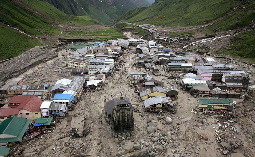
www.ijcrt.org                                            © 2021 IJCRT | Volume 9, Issue 3 March 2021 | ISSN: 2320-2882
2.2 Impact of the Disaster:

As per report made available by the State Government, a total of 4,200 villages were affected, 11,091 livestock were lost and 2,513
houses were fully damaged. More than 70,000 tourists and 1,00,000 local inhabitants were stranded in the difficult mountain terrain
of the upper reaches of the Himalaya. The damage was so enormous and extensive that it was also termed as Himalayan Tsunami
by the media. The extent of damage as reported by State Government is depicted in Table 2.
The suddenness of the flash floods coupled with the high velocity of flow laden with heavy sediment, including boulders washed
away pilgrims and locals. Apart from flash floods, people were also reported to be killed by landslides, which buried them alive
under huge debris and rock falls. The difficult terrain and blockage of roads made it difficult to provide necessary relief to the
survivors stranded at isolated locations. The harsh weather conditions i.e. continuous rainfall, chilling cold and non-availability of
proper shelter/clothes contributed to the misery endured by the survivors of the disaster. [6]

                              Table 2. The extent of damage as reported by the State Government

   S. No                                         Item                                                           Details
     1      Number of affected districts                                                               13
    2,3     Number of dead and missing persons (Presumed to be dead)                                   (169 + 4021)
     4      No. of houses damaged :-                                                                   2119
            (i) Fully damaged pucca houses                                                             3001
            (ii) Severely damaged pucca houses                                                         11759
            (iii) Partially damaged pucca houses                                                       394
            (iv) Fully damaged kuchha houses                                                           360
            (v) Severely damaged kuchha houses                                                         1676
            (vi) Number of kuchha houses partially damaged                                             471
            (viii) Cowsheds damaged                                                                    361
     5      Animals lost :-
            (a) No. of big animals lost                                                                3280
            (b) No. of small animals lost                                                              7811

                                    Fig 4. Damage done by Uttarakhand 2013 Flash Floods

     IJCRT2103300          International Journal of Creative Research Thoughts (IJCRT) www.ijcrt.org                      2404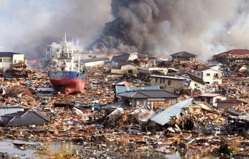
www.ijcrt.org                                            © 2021 IJCRT | Volume 9, Issue 3 March 2021 | ISSN: 2320-2882
3. Causes of the Disaster:

3.1 Natural Causes:
The disaster essentially occurred due to wide spread heavy rains during the period 14-18 June, which resulted in flash floods in all
the major river valleys in the State. Heavy rains triggered major landslide at numerous locations causing severe disruption in surface
communications.
The heavy rainfall in the region was the result of convergence of the southwest monsoon trough and westerly disturbances (Figure
5), which led to the formation of dense clouds over the Uttarakhand Himalaya.

                          Fig 5. Map showing fusion of Westerlies and Monsoon clouds in June 2013

As per the Indian Meteorological Department (IMD), the rainfall in the State between 15 June and 18 June 2013 was measured at
385.1 mm, against the normal rainfall of 71.3 mm, which was in excess by 440 per cent. Thus, it can be inferred that the disaster
was the result of extra precipitation in a very short duration of time, which resulted in heavy water discharge in various rivers and
streams.
                                      Table 3. Showing the rainfall comparison on flood day

                                        Precipitation during Disaster
                  450
                  400                                                              385MM

                  350
                  300
                  250
                  200
                  150
                  100                     71MM
                   50
                    0
                              Avg Rainfall between 15-18 June        Measured Rainfall between 15-18 June

     IJCRT2103300          International Journal of Creative Research Thoughts (IJCRT) www.ijcrt.org                      2405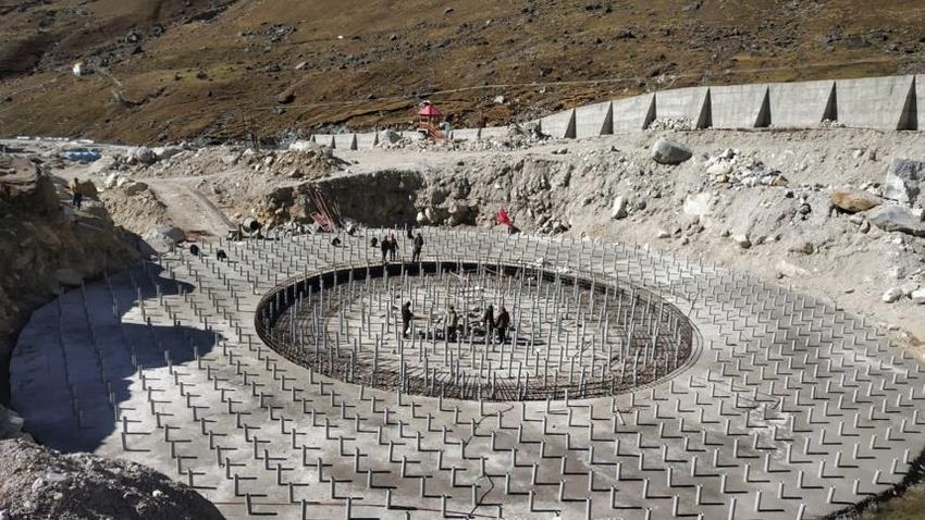
www.ijcrt.org © 2021 IJCRT | Volume 9, Issue 3 March 2021 | ISSN: 2320-2882
The worst impacted settlements was:
Kedarnath shrine area (Gaurikund to Kedarnath),
Mandakini valley,
Alaknanda valley (at Gobindghat and upstream),
Pindar valley, and along the banks of the river Kali in Dharchula area.
The Kedarnath area in particular was impacted the most as it suffered unprecedented devastation with very heavy loss of life and
property. Kedarnath Dham Township is located at an altitude of 3583m on the banks of the river Mandakini, which originates from
the Chaurabari glacier - about 4 kilometers upstream. It is connected by a motorable road from Rudraprayag up to Gaurikund (40
kms) and thereafter through a mule track (14 kms), running along the Mandakini river.
A satellite view of the Kedarnath area, showing the Chorabari Lake, drainage system and the township is given at Figure 6. The
river Mandakini joins river Alaknanda at Rudraprayag.
Fig 7. Satellite view of Kedarnath showing drainage system, glaciers, lake and township
The likely causes for the disaster in the area of Kedarnath have been a subject of several assessments. As per the Geological Survey
of India (GSI), heavy rainfall, which was about 375 per cent more than the benchmark rainfall during normal monsoon, caused the
melting of Chorabari Glacier at the height of 3800 metres. This resulted into eruption of the Mandakini River causing heavy floods
in the Rudraprayag district and adjacent areas. It was also observed that the heavy rains between 15 and 17 June resulted in
exceptionally high rise in the river discharges. The rise in the river level was of the order of 5 - 7m, where the valley was wide and
10 – 12m where the valley was narrow. In the upper stretches of the Mandakini river the stream gradient is high and valley profile
is mostly narrow. The gush of water running down from Kedarnath and Rambara areas brought mammoth sediment load which
consisted of huge rock boulders with diameter ranging from 3 - 10m. The heavy sediment load along with big boulders acted as a
tool of destruction and obliterated everything that came in its way. The enormous volume of water also induced toe erosion along
all the river valleys, which in turn, triggered landslides at a number of places.
As per the eye witnesses and technical inputs received from various agencies, the possible causes of the disaster could be
summarized as:-
1. Collision of western disturbances with monsoon easterlies.
2. Glacial Lake Outburst Flood (GLOF)
3. Excessive precipitation in very short span of time.
4. Heavy erosion and the accumulation of large volume of water and sediment accumulation in major river beds due to
excessive rainfall.
IJCRT2103300 International Journal of Creative Research Thoughts (IJCRT) www.ijcrt.org 2406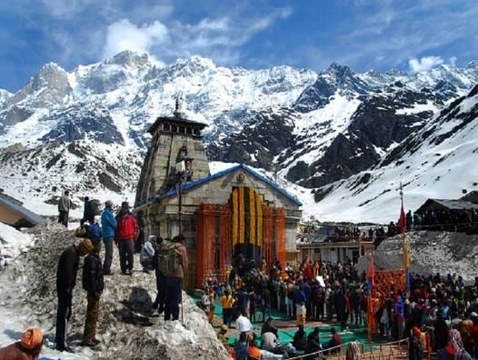
www.ijcrt.org © 2021 IJCRT | Volume 9, Issue 3 March 2021 | ISSN: 2320-2882
5. Run - off of loose debris, moraine and boulders with excessive force washing off all that came in its way.
Fig 8. Satellite view of Kedarnath before and after flashfloods
3.2 Man-made Causes:
3.2.1 Ecology disturbance due to Non- scientific Construction
Haphazard, unregulated construction of roads and bridges was allowed on crumbling, landslide-prone ridges and steep slopes,
ignoring the region's fragile geology and high earthquake vulnerability. Forests were destroyed on a large scale. Hundreds of
buildings were constructed in the flood plains of rivers, their "natural" terrain, which should be no-go areas. Riverbeds were
recklessly mined for sand. As construction debris accumulated, land contours and flows of streams and rivers changed.
Fig 9. Construction debris and activities along Mandakini River near the base from where the trek to Kedarnath begins
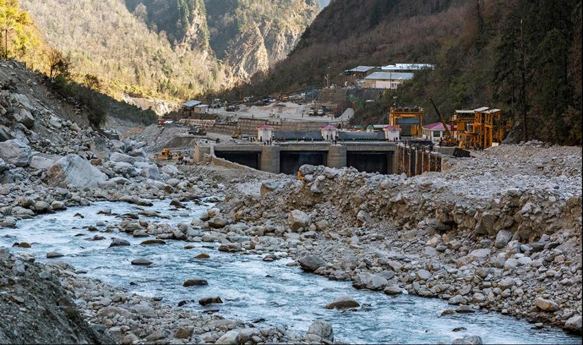
Indiscriminate building of hydroelectric dams was the worst culprit. These involve drilling huge tunnels in the hills by blasting
rocks, placing enormous turbines in the tunnels, destroying soil-binding vegetation to build water channels and other infrastructure,
laying transmission lines and carelessly dumping excavated muck. Many dams have been built on the same river so close to one
another that they leave no scope for its regeneration.Dams steal water from local people. They alter the hydrological cycle and
natural course of rivers. Uttarakhand's 70 completed large dams have diverted more than 640km, equivalent to half the length of its
IJCRT2103300 International Journal of Creative Research Thoughts (IJCRT) www.ijcrt.org 2407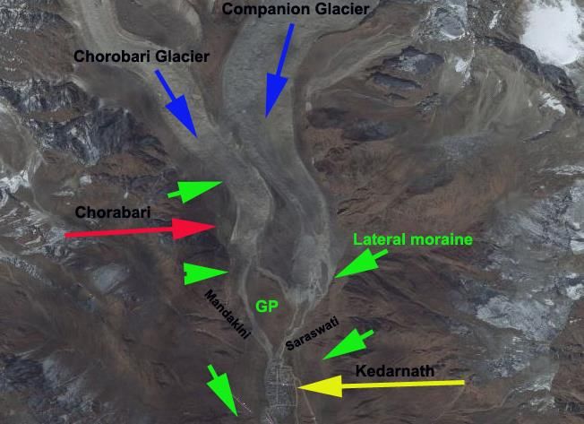
www.ijcrt.org                                         © 2021 IJCRT | Volume 9, Issue 3 March 2021 | ISSN: 2320-2882
major rivers. They have profoundly destabilised its ecology. Yet another 680 dams are reportedly in various stages of
commissioning, construction or planning, mainly by private companies, which would be largely unaccountable. [7]

              Fig 10. Vishnuprayag Hydroelectric Project on the Alaknanda River damaged by the flashfloods

The 400-megawatt Vishnuprayag Hydroelectric Project on the Alaknanda River was buried in mud & boulders, turning its
backwater area for water storage into field of rubble. It took five months to dig this much of the dam out of the pile of boulders. [8]

3.2.2 Heavy rainfall warning ignored by Uttarakhand Government.
The warning from the meteorological centre in Delhi, which caters to the meteorological requirements of seven states of north India
started to pour in for Uttarakhand from June 13. The 24-hours advance prediction of rather heavy rains (35.6-64.4 mm) on the first
two days changed to heavy rains (64.5-124.4 mm ) by June 15. For June 16 and 17, the centre issued warning for extremely heavy
rains (more than 244.5 mm). These were the two days when Uttarkashi and Chamoli district witnessed maximum rains and the
resultant disaster. [7]

3.2.3 Ignorance of fault lines during road construction:
The seismic fault lines were not kept in mind while building roads. These faultlines, which are active and seek back and forth
movements have been cut in many places by roads. As a result, tiny seismic movements in the faultlines weakens the rocks at the
base of the roads making these stretches susceptible to cave-ins and slides.

3.2.4 Drainage negligence:
Buildings have been constructed over old drains and streams, blocking the natural pathways of rainwater. One of the reasons for
the devastation at Kedarnath was the people had constructed houses on the west stream of the Mandaki River that had been dry for
decades. When the river returned to its old course following the deluge, these constructions were washed away.
Another transgression was construction on river flood ways. “In places along Alakananda/Ganga such as Karnaprayag and
Rishikesh, constructions have taken place on the lower terraces which are part of the flood way. [9]

       Fig 11. Illustration showing how floods occur                      Fig 12. Chardham Tourism Data from 2011 to 2017
3.2.5 Huge tourist influx from India and around the world

Hill state Uttarakhand is not only geologically unstable but also ecologically sensitive. The state’s economy is majorly based on
tourism. The number of people visiting the state as tourists is huge. To cater to tourists, deforestation, mindless construction of
hotels and lodges on river edges, widening of narrow lanes is happening on a large scale. These activities are cutting right into the
     IJCRT2103300           International Journal of Creative Research Thoughts (IJCRT) www.ijcrt.org                      2408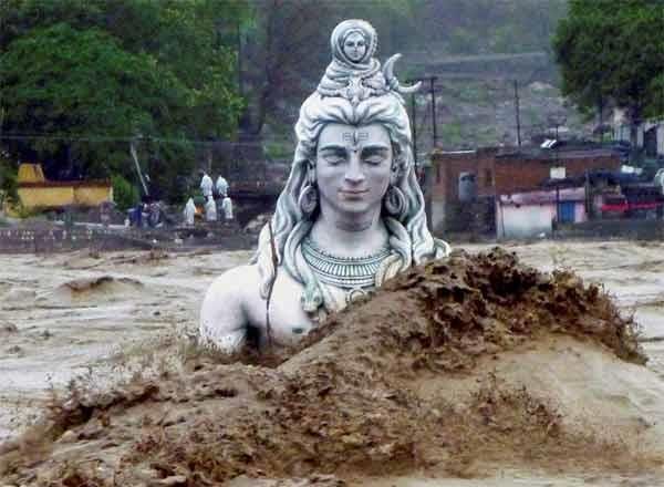
www.ijcrt.org © 2021 IJCRT | Volume 9, Issue 3 March 2021 | ISSN: 2320-2882
toes of the delicate slopes of the state, thereby adding to the destabilizing process and exposing the state to nature’s
fury.According to the draft tourism policy 2017 of the Uttarakhand government, the number of tourists visiting Uttarakhand has
consistently increased from around 11 million in 2000 to 28 million in 2012.
Following the 2013 disaster, it saw a dip but by 2015 the number was near 25 million. In 2018, it is expected to break all previous
records and cross 30 million tourist arrivals – almost three times the population of Uttarakhand itself. By 2026 the number of
tourists is expected to touch a whopping figure of 67 million.
4. Disaster Recovery:
4.1 Rescue and Relief:
Government of India supported the State Government in carrying out its evacuation and relief operations by providing support
of armed forces and paramilitary forces, including National Disaster Response Force (NDRF).
NDRF deployed 14 teams for the operation and rescued more than 9,044 persons.
Indian Air Force had deployed about 45 helicopters and rescued more than 23,500 persons.
Indian Army had deployed 8,000 personnel including 150 Special Forces
Nehru Institute of Mountaineering, Uttarkashi, formed five rescue teams of 20 instructors and local youth, and evacuated
more than 6,500 stranded persons.
More than 1.35 Lacs persons were evacuated from the affected areas in the shortest possible time, despite widespread
destruction of roads, difficult terrain and extremely hostile weather.
All the essential supplies like food, drinking water, medicines, kerosene oil, solar lamps, etc. were continuously provided
by air dropping as well as by surface means.
A total of 69 relief camps were run, where 1,51,629 pilgrims/ local residents were looked after. Some camps continued
operating beyond the emergency phase for the local residents. Approximately 900 trucks of relief material were received
from other states and dispatched to the affected districts from a nodal/ relief centre, set up at Dehradun.
To restore the communication, 105 satellite phones were distributed by the Government of India to various Central and
state agencies. Besides, the efforts of BSNL towards restoration of communication were closely monitored by the National
Crisis Management Committee. [8]
Fig 13. Rescue operations during and after flashfloods
4.2 Recovery and Reconstruction:
The government devised a two-pronged strategy to restore the Kedarnath temple area. In the first phase, the government
would construct protection walls behind the 800 year old Lord Shiva temple, re-channelizing Mandakini and Saraswati
rivers and taking flood control measures at Kedarnath area. The restoration work of the Kedarnath shrine will only be done
by the Archaeological Survey of India (ASI).
IJCRT2103300 International Journal of Creative Research Thoughts (IJCRT) www.ijcrt.org 2409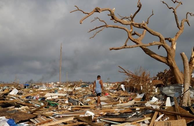
www.ijcrt.org © 2021 IJCRT | Volume 9, Issue 3 March 2021 | ISSN: 2320-2882
Fig 14. Sunken Samadhi Sthal of Shri Adishankaracharyaji Fig 15. Retaining wall along Mandakaini River
As part of the overall master plan for the Kedarnath, river edge protection is to be developed along this 350+ meter long
river edge on eastern bank of river Mandakini. The proposed river edge Mandakini river will help in multiple ways;
defining the flow of the river, protecting the soil from further erosion and providing platforms for views as well as
providing Infra and Services path on the Western side of Kedarpuri. [10]
In the second phase, the government would develop a new township at Lyncholi near Kedarnath and also a ropeway from
Lyncholi to Kedarnath. All those buildings that have been declared unsafe at Kedarpuri will be demolished. The work for
the stabilization of slopes will also begin.
Construction of 9km long road across Mandakini river
4.3 Kedar Valley Projects:
There is greater vision of development of Kedar valley with multiple interventions along with the development of Kedarpuri The
flow of Mandakini River and topography of Kedarpuri give the favorable conditions for the formation of Ghats at the confluence
point with Saraswati River. This development will allow the pilgrims to perform any religious ceremonies, adding strength to the
values of Kedarnath Dham
Maun Gufa / Meditation Caves along the Tirth yatra route (5 nos.)
Smriti-van Memorial at foothills
Road widening and Construction of Rambara to Garudchatti (5.25km - 1.9km Existing, 3.9km New)
Road widening and Construction of GarudChatti to Kedartown (3.6 km)
Saraswati Ghats & Retaining wall (JSW funded Project )
Mandakini Ghats & Retaining Wall (Government Funded Project)
Kedarpuri Central Approach Street widening & Grading (ONGC Funded Project)
Shri Shankaracharya Samadhi/Virtual Museum (JSW funded Project)
Guest Houses (8 nos.) on Saraswati & Mandakini River-banks
Kedarpuri Infrastructure Project: Storm Water, Solid Waste Management, Water Supply, Electrification, Lane Cabling &
other Sustainable Solutions.
Balance 70 Houses for Tirth Purohits in Kedarpuri 12. Laser/Light and Sound show on mountain slopes
However the government has not shown keen interest and very few is done as compared to whats there in the proposal for the valley
post the flashfloods. The construction of sunken Shri Adishnakaracharya Samadhi Sthal behind the Kedarnath Temple is a matter
of concern as it will become a catchment area for the snowfall and will put pressure on the vallry. The deforestation for widening
of roads and settlements may disturbed the ecology and should be counter strategically by the executing bodies and the government
as cutting of 33000-43000 of trees have already been given approval by the environmental ministry.
5. Conclusion:
1. The rising number of tourists in Uttarakhand is only going to intensify violations of construction laws as there will be
competition to provide resources for them. The state government should ensure to enforce building by-laws to regulate
constructions along the river banks.
2. Trained the local people on how to reduce the impacts of the disasters and build the disaster resilient towns.
3. Heavy buildings should not be constructed over glacier debris.
4. Non-scientific constructions which make the area more vulnerable to floods should be avoided.
5. Deforestation should be avoid as it may disturbed the ecology as well can lead to the landslides in the future.
6. Proper management of construction waste materials should be done or else the waste will be dump in the rivers polluting
the water.
7. An integrated solid waste management plan should be prepare keeping in mind the natural drain.
8. There is a need to move towards an environment friendly construction approach to use the resources in a sustainable
manner.
9. A community participatory approach should be used to make the new township as it will help in rehabilitating as well as
providing livelihood to the floods victims.
IJCRT2103300 International Journal of Creative Research Thoughts (IJCRT) www.ijcrt.org 2410www.ijcrt.org © 2021 IJCRT | Volume 9, Issue 3 March 2021 | ISSN: 2320-2882
References:
[1] National Institute of Disaster Management
[2] Disaster Management in India: Emerging Issues & Responses
[3] https://www.jagranjosh.com/general-knowledge/list-of-major-natural-disasters-in-the-history-of-india-1590147440-1
[4] https://en.wikipedia.org/wiki/2013_North_India_floods
[5] India Disaster Report 2013
[6] https://www.downtoearth.org.in/news/uttarakhand-government-ignored-met-warning-41421
[7] https://www.theguardian.com/commentisfree/2013/jun/28/india-floods-man-made-disaster
[8] https://dhruvmalhotra.com/dams-floods-in-uttarakhand
[9] https://timesofindia.indiatimes.com/india/why-scientists-think-kedarnath-is-at-risk-again/articleshow/74627254.cms
[10] INI Design Studio, Kedarnath Redevelopment & Restoration Project
IJCRT2103300 International Journal of Creative Research Thoughts (IJCRT) www.ijcrt.org 2411You can also read