WATERHALL PARK, MILTON KEYNES - Understanding Historic Parks and Gardens in Buckinghamshire - Buckinghamshire ...
←
→
Page content transcription
If your browser does not render page correctly, please read the page content below
Understanding Historic Parks and Gardens
                in Buckinghamshire
 The Buckinghamshire Gardens Trust Research & Recording Project

WATERHALL PARK, MILTON KEYNES
                        June 2021
                                          Roland
                                          Callingham
                                          Foundation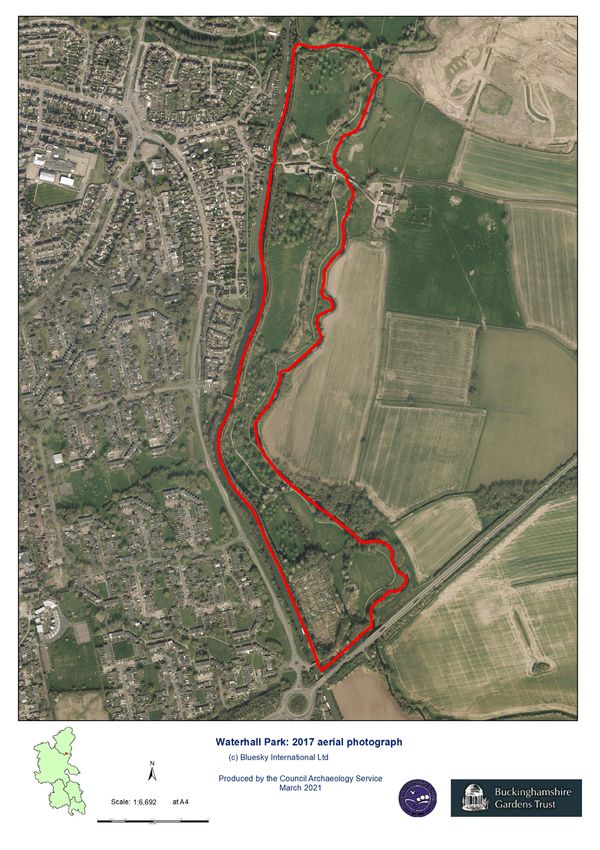
Bucks Gardens Trust, Site Dossier: Waterhall Park, Milton Keynes, MKC June 2021
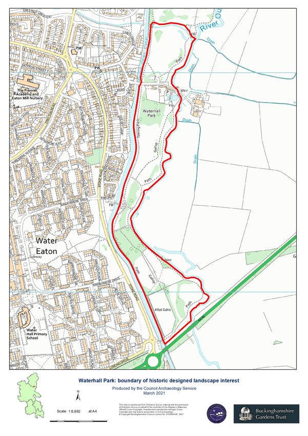
HISTORIC SITE BOUNDARY
2
Bucks Gardens Trust, Site Dossier: Waterhall Park, Milton Keynes, MKC   June 2021

                                                             3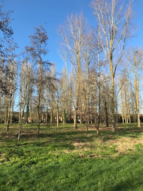
Bucks Gardens Trust, Site Dossier: Waterhall Park, Milton Keynes, MKC                             June 2021

INTRODUCTION
Background to the Project
This site dossier has been prepared as part of The Buckinghamshire Gardens Trust (BGT) Research
and Recording Project, begun in 2014. This site is one of several hundred designed landscapes
county‐wide identified by Bucks County Council (BCC) in 1998 (including Milton Keynes District) as
potentially retaining evidence of historic interest, as part of the Historic Parks and Gardens Register
Review project carried out for English Heritage (now Historic England) (BCC Report No. 508). The list is not definitive
and further parks and gardens may be identified as research continues or further information comes to light.

Content
BGT has taken the Register Review list as a sound basis from which to select sites for appraisal as
part of its Research and Recording Project for designed landscapes in the historic county of Bucks
(pre‐1974 boundaries). For each site a dossier is prepared by volunteers trained on behalf of BGT by experts in
appraising designed landscapes who have worked extensively for English Heritage/Historic England on its Register
Upgrade Project.

Each dossier includes the following for the site:
       A site boundary mapped on the current Ordnance Survey to indicate the extent of the main part of the
       surviving designed landscape, also a current aerial photograph.
       A statement of historic significance based on the four Interests outlined in the National
       Planning Policy Framework and including an overview.
       A written description, derived from documentary research and a site visit, based on the
       format of the English Heritage (now Historic England) Register of Parks & Gardens of special
       historic interest 2nd edn.
       A map showing principal views and features.

The area within the site boundary represents the significant coherent remains of the designed
landscape. It does not necessarily include all surviving elements of the historical landscape design,
which may be fragmented. It takes no account of current ownership.

NOTE: Sites are not open to the public unless advertised elsewhere.

Supporters and Acknowledgements
The project was supported by The Gardens Trust (formerly the Association of Gardens Trusts and the Garden History
Society) and funded by BGT with significant grants from the Stanley Smith Horticultural Trust, the Finnis Scott
Foundation, BCC and other donors. BCC generously provided current and historic mapping and access to the Historic
Environment Record was provided by Milton Keynes Council.

The Trust would like to thank the volunteers and owners who have participated in this project and
given so much time and effort to complete this challenging and rewarding task.

Further information is available from: www.bucksgardenstrust.org.uk

                                                                   4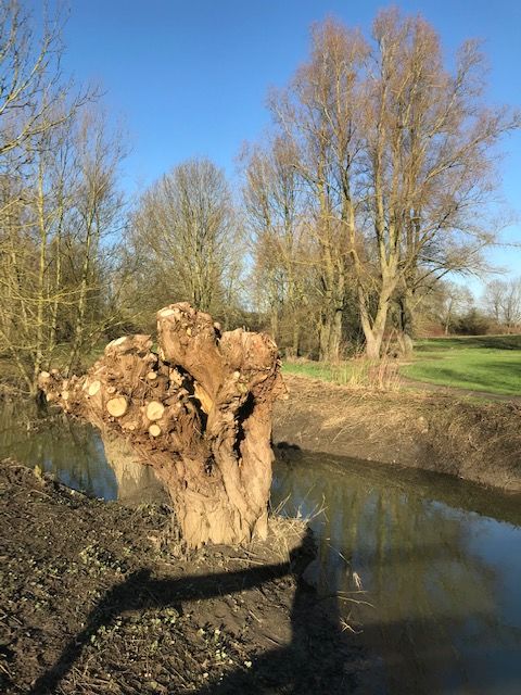
Bucks Gardens Trust, Site Dossier: Waterhall Park, Milton Keynes, MKC                          June 2021

COUNTY:                BUCKINGHAMSHIRE                                 WATERHALL PARK, MILTON KEYNES

DISTRICT:              MILTON KEYNES

PARISH:                MILTON KEYNES                                   MK HER: -

OS REF.:               SP 881 324

STATEMENT OF SIGNIFICANCE

Overview

This report is one of a group covering the landscape of the New Town of Milton Keynes. The others to date are on
Central Milton Keynes, Campbell Park, the Willen Lakes, the Tree Cathedral at Newlands, the Ouzel Valley Park and
Caldecotte Lake. Apart from Central Milton Keynes, the public areas of these landscapes have been under the
ownership and care of the Milton Keynes Parks Trust (MKPT) since 1992.

Waterhall Park is the southern tip of the Ouzel Valley Park, one of the three large linear parks which were key parts
of Milton Keynes Development Corporation’s (MKDC: The Design Guide: Section 3: Landscape, Parks and Open
Spaces) planned cityscape, enhancing the original landscape of rolling undramatic countryside to provide a new
landscape character of sufficient strength to contain new city developments and create significant areas of useable
countryside within the city boundary. The linear parks follow the valleys of two small rivers, the Ouzel and Loughton
Brook, together with the larger valley of the River Ouse to the north. They form the recreational and environmental
lung of the city, as well as being an essential component of managing flooding. Waterhall is in Bletchley and
therefore outside the New Town area, but it was planned by MKDC to enhance the recreational amenities of the
town and to link with the wider elements of the new landscape north through connections with Caldecotte Lake, the
Ouzel Valley Park and Willen Lakes.

The park areas of Milton Keynes were designed around a framework of “strings, beads and settings” (MKDC original
design guide). The strings are linear footpaths, cycleways, greenways and riding trails. Beads are activity centres. The
setting is the visually or physically public landscape which makes up the body of the park. Land uses in this area
include grazing, sports grounds, lakes, wildlife zones and events areas etc., many of which generate income which
contributes to the management costs of the parks.

Waterhall Park is part of a landscape system where the details of the materials, types of horticultural features and
planting all work with the natural and artificial topography to produce an outstanding unified design. It survives
intact and continues to be developed in similar character following the vision of the Milton Keynes Parks Trust.

 Archaeological interest

The archaeological evidence has been extensively studied as part of the development of the area. Finds from Roman
times at or near the site, which is near to Watling Street and the small Roman fort of Magiovinium, close to Fenny
Stratford and the River Ouzel to the north indicate potential for further Roman evidence. Evidence of later
occupation includes an Anglo Saxon settlement at Saffron Gardens north of Waterhall Park and a Saxon Mill at Water
Eaton to the west (City Discovery Centre B060/87).

                                                                   5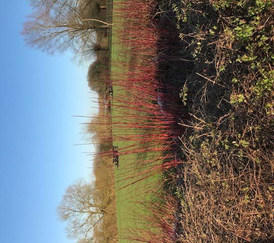
Bucks Gardens Trust, Site Dossier: Waterhall Park, Milton Keynes, MKC                           June 2021

Architectural interest

The site makes a feature of the late C18 Grand Union Canal and its embankment, original accommodation bridge
(designed to retain existing access), and small viaduct over the Water Eaton Brook. The mid C19 buildings (listed
Grade II), now a private house, were originally a watermill and connected house and form a picturesque focus for
the Park and for views across the landscape beyond.

Artistic interest

Waterhall Park is part of an ambitious publicly funded park system on a scale rarely achieved in later C20/21
England, building on the traditions set by the best C19 parks. Neil Higson, Chief Landscape Architect for MKDC has
said his inspiration was primarily the Garden City movement based on Ebenezer Howard’s book Garden Cities of
Tomorrow. Other inspirations were the great mid-C19 “people’s parks”, Birkenhead Park and Sefton Park, Liverpool,
and the wooded setting of Helsinki and Tapiola New Town, Finland (Higson, N. Parks in Milton Keynes, Bucks Gardens
Trust newsletter July 2020)

 In scale of ambition and unity of design the group of Milton Keynes landscapes to which Waterhall Park belongs
(Ouzel Valley Park, Caldecotte Lake, the Tree Cathedral and Willen Lakes) is comparable with the Thames Barrier
Park, the Yorkshire Sculpture Park and the Olympic Park, but in style and character these are all very different.
Waterhall Park is laid out in a latter day naturalistic English landscape style providing a setting for new urban
development. The views are carefully manipulated to take advantage of the gently rolling topography.

Historic interest

Waterhall Park is of high historic interest as part of a set of designed landscapes for public use developed in the later
C20 in England, and for its high quality of design and survival intact.

HISTORIC DEVELOPMENT

Waterhall Park terminates the south end of the Ouzel Valley Park. Though within the Milton Keynes Council
boundary, Waterhall is outside the planned New Town, to the south in Bletchley. Bletchley is situated at the
meeting places of the major north/south route through the Tring gap in the chalk hills outside London and the
east/west route between Oxford and Cambridge with archaeological remains from Roman and Anglo Saxon times.
The medieval town was built west of the River Ouzel, away from winter floods and the Park takes its name from the
local manor, whose estate it was once part of (www.theparkstrust.com). By the C19 three railway routes and the
Grand Union Canal all went through the area, but the town had split centres and did not develop to exploit the
benefits of its location (Shelton).

During and after World War II Bletchley Urban District Council (UDC) advocated for the town to be regenerated
under the New Towns programme. Bletchley was included in the Abercrombie Greater London Plan 1943/44 as one
of the designated New Towns, with an expected population of 50,000. Although these plans were abandoned for
economic reasons, the UDC pressed ahead with new housing and amenities and in 1952 committed to build 1,500
houses over five years costing £3.5m. In 1964 the UDC planned to grow the town to 150,000 in 25 years (Hill).

However, under the Town and Country Planning Act of 1947 UDCs could not make unilateral plans and had to take
account of the County Development Plan. By the 1950s the Buckinghamshire economy in the north was declining in
comparison with the prosperous south and Buckinghamshire County Council (BCC) began planning for major
development (Piko). BCC did not share Bletchley UDC’s vision for their town. Instead in 1966 BCC published a plan
for a North Bucks New City which would fill in the space between Bletchley and Wolverton, to the north, rather than

                                                                   6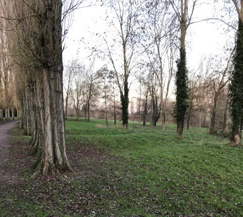
Bucks Gardens Trust, Site Dossier: Waterhall Park, Milton Keynes, MKC                        June 2021

develop an existing town. The local Gazette remarked “We live in a funny age if, as would seem to be the case, the
lusty town, so anxious to grow, is neglected in favour of an embryo city, so recently conceived and destined for a
long period of gestation, if ever it is born”. (Gazette, 21 November 1964, quoted in Hill).

In 1967 Milton Keynes was designated as the New Town and the Master Plan was published in 1971. Landscape was
worked out in its broad outlines from the beginning (Pevsner), with generous standards of open space, including
landscape design principles (see Appendix for details). Milton Keynes Development Corporation (MKDC) was
established as the body with responsibility for taking the Master Plan forward. Neil Higson was appointed Chief
Landscape Architect in 1977 and he strengthened the landscape architecture function and team. He drew up park
development plans and introduced central purchasing of plant material to ensure consistent quality.

Local plan studies and MKDC documents (Technical Supplement No 6 District and Local Plan Studies 1971; CDC
B060/87 and Special Study of Bletchley commissioned by Bletchley UDC and MKDC, 3/69, CDC B060/87) from the
early 1970s state that Bletchley was already developed and therefore the potential for creating an environment
comparable to that of the new city areas, would be restricted. Generally, it was considered that Bletchley had a high
acreage of open space per head, but this was patchy, not as fully developed as it could be and not easily accessible.
Land between the Grand Union Canal and the River Ouzel on the eastern edge of the town was thought suitable for
recreational development. This had not been built on because the river was prone to flooding and was already the
site of Manor Fields Sports Ground and allotments.

An MKDC map from 1970 (MKDC Internal Report) shows how this area on the east edge of Bletchley would fit with
the linear park to the north, including the new lake planned for flood control purposes at Caldecotte. This would be
accessible along the Ouzel which would flow under a new urban motorway to the north east of Waterhall. West of
this new road, between the Grand Union Canal and the Ouzel, would be a narrow corridor running north/south and
featuring camping and picnic grounds, playing fields, playgrounds, allotments with provision for car parking. The
existing Manor Fields Playing Fields would be incorporated.

The 1980 Linear Park Local Plan (MKDC, CDC B060) is nearly identical, but more informal grassland and woodland
were envisaged. Both maps envisaged an extension of the grid road system (Marlborough Street), running
north/south parallel to the urban motorway and which would have turned west, separating the current Waterhall
Park from the Playing Fields to the north. At some point these plans were abandoned, Marlborough Street was not
extended and the Park continues to be accessed by the small urban streets which predate MKDC. The continuation
of the recreational area from Caldecotte along the river south through Bletchley was, however, undermined by the
development of a large warehouse between Fenny Lock and Caldecotte on a site zoned for open space in 1970.
Nevertheless, there remains a link between Waterhall and the wider landscape network to the north via the
Broadwalk along the Grand Union Canal.

Neil Higson recalls that ‘Waterhall Park was a somewhat neglected part of the MK parks system and initially
functioned as a local park rather than an acknowledged element of the overall park network. Later on we clarified
connections and its wider role as an important link for Bletchley to the “new City” became more established.
(pers. comm. 22 April 21)

MKDC was wound up in 1992 and a charitable trust, Milton Keynes Parks Trust, (MKPT), was established to be
responsible for parks and green spaces in Milton Keynes, as they had more in common with nature reserves and
country parks than traditional town parks. MKPT was given a 999 year lease with a property endowment to provide a
revenue stream. It became fully operational in July 1992 (Leisure Management, March 1996).

                                                                   7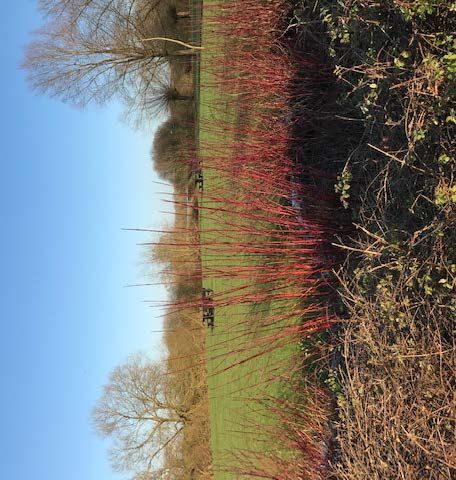
Bucks Gardens Trust, Site Dossier: Waterhall Park, Milton Keynes, MKC                          June 2021

SITE DESCRIPTION

LOCATION, AREA, BOUNDARIES, LANDFORM, SETTING

Waterhall Park is on the eastern edge of Bletchley, along the west bank of the River Ouzel which forms the boundary
with two local authorities. On the east bank at the north end the land is within Milton Keynes Borough Council and
to the south it is within Aylesbury Vale Area of Buckinghamshire Council.

The 23 ha. area is c.1.5 km north/south and is a narrow and irregular rectangle, following the line of the river. The
north section is about 200m wide; the Park then narrows to less than 100m just before widening out to 300m at the
south end where there is a weir. The meandering east boundary is defined by the River Ouzel; the straight west
boundary is the Grand Union Canal. The north boundary is Water Eaton Brook, which flows into the Ouzel and the
Park ends at the south by the A4146, where there is a grassy embankment. Over the next few years the Park will be
extended on the east side of the river in association with new developments between the river and the A4146.

The soil is clay with river gravels. The landform slopes gently east to the river from the bank containing the Canal.
This gives a formal west boundary to the Park, with a line of Lombardy poplars on the Broadwalk. The land dips at
the north end where Water Eaton Brook meets the Ouzel and as a result the Broadwalk slopes down at this point,
before rising as it meets Saffron Gardens. The lowest point coincides with the high point of the embankment at a
brick viaduct about 10m high over the Brook. The viaduct forms part of the C18 construction of the Grand Union
Canal and is a relatively small but imposing architectural feature which contributes to the industrial history.

The land was formerly agricultural; ridge and furrow remains, especially to the south. Much of the land is kept
informal and naturalistic by the Parks Trust, with for example cutting of the hay meadows to encourage biodiversity.
Some areas have Cricket Bat willows, which are grown as a commercial crop. Scarce native Black Poplars, once
common in the area, are coppiced to provide cuttings to plant elsewhere in Milton Keynes. The area to the east
floods and an undated photograph (www.livingarchive.org.uk) shows the river swollen at Fenny Stratford, just to the
north, with low banks and willows. This view is still characteristic of the area.

The setting to the west beyond the Canal is mostly 1960s housing estates. A small group of older buildings, some
C17, stands by the entrance to the Park from Mill Road. To the north, beyond Water Eaton Brook is Saffron Gardens
local park, with allotments and Manor Fields Sports Ground.

To the east the Park when designed overlooked a continuation of the original farmland, both pasture and arable,
with farm buildings, and views towards the Brickhill Woods, contributing an air of spaciousness. This site however is
being developed and building has recently started in the north section within Milton Keynes. Planning permission
was given for about 500 houses plus a school and amenities, including open space, in 2017. At the time permission
was also granted by Aylesbury Vale Council to build 1600 houses, plus associated infrastructure on land to the south.
This development has been halted because the area is deemed a flood risk (Milton Keynes Council design code
17/02723, 2017 and Aylesbury Vale Housing and Economic Land Availability Assessment 2019). At least for the time
being this aspect of the Park’s original setting can still be enjoyed.

ENTRANCES AND APPROACHES

The three entrances to the Park, each give access from the housing estates to the west.

In the north a road turns east from Mill Road, over a late C18 accommodation bridge, No 93 (Pevsner) across the
Canal, past the Mill House and outbuildings to the south, before turning north into a small car park. The car park is
screened by trees and more formal shrubs, including pink snowberry (Symphoricarpus x chaultii), rather than the

                                                                   8
Bucks Gardens Trust, Site Dossier: Waterhall Park, Milton Keynes, MKC                           June 2021

more common white snowberry used elsewhere. This use of the plant to differentiate between areas can also be
seen at Caldecotte (q.v.).

Further south a specially designed footbridge over the Canal leads east from Windermere Drive. This leads down a
flight of steps into a small garden, which forms the entrance to this section of the Park. At the southern point of the
Park a second road access from Stoke Road crosses the Canal to a car park by the allotments in the south west
corner.

The park can be accessed to the north and south via the Canal Broadwalk. This wide path runs through Milton
Keynes along the Canal and is lined with Lombardy Poplars. It is an example of “the strings”, which link elements of
the landscape together. The Broadwalk in the north passes through Fenny Stratford, where a path turns right to
Caldecotte Lake.

A bridleway runs north-east/south-west from Eaton Leys on the east bank of the Ouzel through the park to turn west
along the outskirts of Water Eaton, just before reaching the A4146 to the south. This crosses the river on a non-
vehicular bridge, which joins the area by the former watermill, which is the continuation of Mill Road. A private road
bridge links the area by the former mill to a farm east of the river.

PRINCIPAL BUILDINGS

Within the site located 1km from the north boundary and Water Eaton Brook, the former watermill and wharf
buildings (Listed Grade II) were built c.1830-50, of two storeys of red brick, with a single storey brick connection. The
group is now a private residence. A disused mill race runs towards the mill. The buildings form a picturesque group
with the old canal bridge and are a focal point within the Park.

PERAMBULATION

A circular walk follows the site boundary, proceeding anti-clockwise from the car park on the east side of the Park
near Mill Road. The route uses the Canal Broadwalk, which runs north to south along the east boundary.

Starting on the east edge of the Park, leading from the small car park by the former mill buildings, a path winds east
towards the river, passes a picnic area and then follows the river bank north. The area is gently undulating grassland
and the parkland supports plants indicative of old pasture. One of the most interesting is meadow saxifrage. In the
summer the areas are cut to different heights and the grass is left long where this plant grows to ensure continued
flowering (MKPT leaflet CDC B060). West of the riverside path a rectangular grassy area stretches to the Broadwalk,
with six island beds forming a loose circle. The planting is informal and graded in height and includes willow, cornus,
acer and holly. Trees line the river bank, mostly willow.

About 0.25km north from the car park, the winding riverside path meets Water Eaton Brook. A footbridge leads to a
path that runs 0.2km east/west along the south side of Saffron Gardens. The area is marshy with a long (0.1km) pond
running by the Brook on the south side, with trees. The view north of Saffron Gardens, on slightly higher ground, is
of a similar grassy area, but without the semi-circular beds and planting. A children’s play area can be seen but
Manor Fields Playing Fields is masked by trees.

To the west, facing the path on the north bank of the Water Eaton Brook, is the Canal embankment, which is
substantial here as the landform is low. A brick viaduct carries the Canal over the Brook. The path turns south, back
over the Brook on a bridge by the viaduct and along the Broadwalk, lined by Lombardy Poplars, to the east of the
Canal. At this point the Broadwalk begins to slope upwards gently.

                                                                   9
Bucks Gardens Trust, Site Dossier: Waterhall Park, Milton Keynes, MKC June 2021
About 0.2km south of Water Eaton Brook the path along the Broadwalk goes south under the Canal bridge and
continues 600m south until it meets the footbridge coming from Windermere Drive to the west. At this point the
Broadwalk goes through the garden creating an entry feature. Further ornamental planting, includes beds of species
roses. This section is narrow (70m east/west). East of the garden is wooded with mixed planting including a willow
plantation, the wood from which is sold for cricket bats.
The Broadwalk continues south for 700m to meet the car park by the allotments in the south-west corner of the
Park. An area of ridge and furrow is visible. The allotments are screened by a mature hedge and small trees. A
footpath along the south edge of the Park runs along the bottom of the embanked A4146 for 300m until meeting the
river, where it turns north-west. Here the park opens into a wide grassy area with views over fields beyond the river
to Brickhill Woods.
About 300m north-west along the river path, is a picnic area to the west and to the east a small, white concrete
riverside building, which is a gauging station used by Anglian Water to measure the flow of water. This functional
building is part of the flood defence scheme along the River Ouzel from Waterhall to Caldecotte Lake and the Willen
Lakes to the north. It would have been obvious in the landscape when built, but is now overgrown. When the
Waterhall stretch of the river was straightened as part of these works, an ox-bow shaped lake was left that was
partially filled and re-excavated to form a pond opposite the gauging station. This area on both river banks is
overgrown with small trees and shrubs.
Local school children worked on the site in the late 1970s and 1980s to improve it for wildlife by planting trees and
cutting the rough grass to enable plants to flower (B060 undated). Schools were intended to continue to use the site
for nature study. A 1977 plan (L3/7/107/6 dated October 1977) shows the filled-in former river course with willows
and standard ash trees to be planted. An undated diagram confirms these intentions (DMKDC/5/11/2/14/3/107/7).
The pond on the east bank of the Ouzel is marked on the MKPT site map by the car park but there is currently no
sign of the nature reserve, or means of access. Environmental education activities continue to be delivered however
by the Parks Trust’s Outdoor Learning Team.
From the gauging station the path continues north-west and the park starts to narrow as it follows a slight bend in
the river. A belt of trees crosses the Park in front of the allotments. About 400m from the south boundary the path
enters the wooded area of cricket bat willow. Two parallel paths, a short distance apart, cross the park east/west
linking the river bank to the Broadwalk by the Canal, in a low lying area prone to flooding.
The path by the river continues north towards the former mill. To the west is a sequence of three island beds, with
similar planting to the ones to the north. Beyond these are the signs of the former mill race. On the river bank is new
tree planting. After further 500m the gently winding path returns to the former mill, alongside the boundary of the
private garden to the south of the building, and meets the road leading east/west over the bridge from Mill Lane.
REFERENCES
Books and Articles
Green, D. and Buckley, R. Bletchley and Fenny Stratford Historic Towns Assessment, Buckinghamshire County Council,
2009, page 22
Pevsner, N. The Buildings of England, Buckinghamshire (2nd edition 1994) page 510
Page, W. ed., Victoria County History, Buckinghamshire, Vol IV Parishes of Bletchley and Water Eaton Pages 274-283
10Bucks Gardens Trust, Site Dossier: Waterhall Park, Milton Keynes, MKC June 2021
Other Documents
Higson, N. Parks in Milton Keynes, Bucks Gardens Trust Newsletter July 2020
MKDC: The Plan for Milton Keynes, Volumes One and Two, 1970, www.theplanformiltonkeynes.co.uk
MKDC: Design Guide: Section 3 Landscape, Parks and Open Spaces 1970, Milton Keynes Council HER records
Leisure Management, March 1996.
Milton Keynes Council design code 17/02723 2017
Buckinghamshire Archive
Waterhall Park Nature Reserve L3/7/107/6 October 1977
Waterhall Park DMKDC/5/11/2/1/4/3/107/7 undated
City Discovery Centre
Hill, Marion, ed. Bigger, Brighter, Better, The Story of Bletchley 1944-66, Living Archive, CDC B060
MKDC: Technical Supplement No 6 District and Local Plan Studies 1971: CDC B060/87
MKDC and Bletchley UDC: Special Study of Bletchley,3/69 CDC B060/87
MKDC Linear Park Local Plan, 1980, CDC B060
MKPT leaflet Waterhall Park, undated, CDC B060
Piko, L. Milton Keynes in British Culture “Imagining England” (2019), CDC B060
Shelton, A. J. Bletchley, The results of planned expansion, BA Thesis University of Manchester (1963), CDC B060/87
Maps and Plans
OS Explorer Map, 2015
Milton Keynes Parks Trust Waterhall Park site display plan 2019
MKDC map 1970, CDC B060/87
Other media
www.theparkstrust.com
www.livingarchive.org.uk
J Stansfield, G Grocott December 2020 Edited SR June 2021
Bucks Gardens Trust is indebted to Neil Higson, Philip Bowsher of MKPT, and Nick Crank of MKC for kindly offering
advice and comments.
11Bucks Gardens Trust, Site Dossier: Waterhall Park, Milton Keynes, MKC June 2021
KEY HISTORIC FEATURES & VIEWS
6
3
1
2
7
4
5
6
12Bucks Gardens Trust, Site Dossier: Waterhall Park, Milton Keynes, MKC June 2021
Key to Numbered Features
1. Accommodation Bridge 2. Old Mill Buildings
3. Viaduct & Water Eaton Brook 4. Entrance from Windermere Drive
5. Water Gauge 6. Broad Walk
7. Ridge & Furrow
Views indicated above include:
• From Old Mill Buildings east to farm at Eaton Leys across river.
• From garden at Windermere Drive north-east through park to Old Mill Buildings and river bank.
• From Old Mill Buildings north/south of river bank.
• From path along river generally views east over countryside.
Appendix One
MKDC Planning Design Brief Principles for Landscapes in the New Town
MKDC set out general principles for landscape design in the Planning Design Brief/ Landscapes were intended to
enhance the natural character of the area and to feature mainly native species. Planting was to be a mix of the quick
and slow growing to provide both immediate impact and sustainability for the long term. Existing features were to
be incorporated where possible, both for preservation and education, including a number of ancient monuments. In
addition, park development principles were adopted, which aimed to combine the advantages of the conventional
town park (unlimited access, but could be costly to create and manage), with those of the open countryside (limited
public access, but an open aspect and less expensive for public agencies to provide and maintain). MKDC wanted a
framework to encourage agricultural, sporting and commercial agencies to be involved in providing features and
activities.
Three main elements were established to determine park planning. In the first instance a network of green corridors,
called “strings” were to be created at an early stage, largely by public agencies, to provide essential continuity for
the system. Focal points, termed “beads”, were then to be created or incorporated within the “strings”. These would
have a variety of uses, including car parks, picnic areas, sculptures and gardens, as well as cafes, pubs and leisure
attractions, which might be wholly or partly funded by the private sector. Finally MKDC called “settings” those areas
which formed the majority of open spaces. This term covered woodland, grassland, grazing and commercial
recreation. Much of which it envisaged being provided by the private sector. Water was also seen as an enhancing
landscape value and as providing opportunities for recreation and sports. Water features included existing rivers and
waterways and artificial lakes, which were constructed to deal with floods.
13Bucks Gardens Trust, Site Dossier: Waterhall Park, Milton Keynes, MKC June 2021
CURRENT IMAGES (2020)
14Bucks Gardens Trust, Site Dossier: Waterhall Park, Milton Keynes, MKC June 2021
15Bucks Gardens Trust, Site Dossier: Waterhall Park, Milton Keynes, MKC June 2021
16You can also read