Users Guide to Dredging in Tidewater Virginia - National ...
←
→
Page content transcription
If your browser does not render page correctly, please read the page content below
Users Guide to
Dredging in
Tidewater Virginia
Providing guidance through a dredging
project - from the identification of a
dredging need, to identification of sediment
disposal site, to applying for a dredging
permit, to the dredging of a channel

Middle Peninsula Planning
District Commission

September 2011

                                               This project was funded the Virginia Coastal Zone
                                               Management Program at the Department of
                                               Environmental Quality through Grant
                                               #NA10NOS4190205 Task 44 of the U.S. Department
                                               of Commerce, National Oceanic and Atmospheric
                                               Administration, under the Coastal Zone Management
                                               Act of 1972, as amended.

                                               The views expressed herein are those of the authors
                                               and do not necessarily reflect the views of the U.S.
                                               Department of Commerce, NOAA, or any of its     Page | 1
                                               subagencies.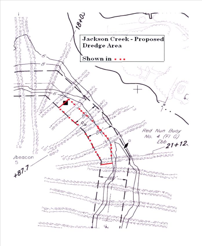
Executive Summary

       As a coastal region, navigable waterways are critical to the economic fabric of the Middle
Peninsula. Open waterways invite residents as well as tourists to explore and enjoy the coastal natural
resources and wildlife of the region.

Over the years, the U.S. Army Corps of Engineers has been responsible to “ensuring navigation on our
nation’s waterways moves safely, reliably, and efficiently with minimal impact to the environment, thus
sustaining a vital component of the economy (USACE, 2010).” In 2009, however, Representative Robert
Wittman held a meeting at the Middle Peninsula Planning District Commission to inform regional
stakeholders that federal funding once available for the dredging of the shallow draft channels (ie.
federally designated channels with depth of -15 feet mean lower low water (MLLW) or less), will no
longer be available in the near future. Consequently localities, commercial property and/or private citizens
will likely bear the burden of funding these shallow draft projects previously funded by the Corps.

The Middle Peninsula Planning District Commission (MPPDC), therefore, partnered with the Middle
Peninsula Chesapeake Bay Public Access Authority (MPCBPAA), Virginia Marine Extension Program, and
the U.S. Army Corps of Engineers to develop a Regional Shallow Draft Navigation and Sediment
Management Plan that provides a matrix of channels designated as Federal Navigation Channels within the
Middle Peninsula that will need to be maintained, the approximate cost of the project, as well as a
recommended timetable to dredge channels within the Middle Peninsula. To supplement that report the
MPCBPAA developed this guidance report to assist localities, as well as commercial property and/or
private citizens with the execution of a shallow draft channel dredging projects (ie. federally designated
channels or non-federally designated channels).

Although each project is unique and may require unique considerations there are a variety of common
components that factor into a successful dredging project within Tidewater Virginia: (1) identification of a
channel with a dredging need, (2) conducting a pre-dredge bathymetric survey to determine the current
condition of the channel and volume of material to be removed, (3) identification and selection of a dredge
disposal site, typically public or, private beaches and/or, private or public upland containment sites, (4)
applying for and receiving the necessary permits via the submission of the Commonwealth of Virginia’s
Standard Joint Permit Application (JPA) and attendance, as necessary, at one or more required public
hearings, (5) selection of a contractor and execution of the contract, (6) convening a pre-dredging
conference with representatives from the appropriate regulatory agencies, (7) initiation and completion of
the proposed dredging project, and (8) submission of a post-dredge bathymetric survey to permitting
authorities for determination of permit compliance. As each component influences the overall cost of a
dredging project it is important that applicants, whether a public entity, private entity or a public private
partnership, weigh the various options as federal funding to maintain shallow draft navigable waterways
will likely no longer be available in the future.

                                                                                                     Page | 2
Introduction
In October 2010, the Middle Peninsula Planning District Commission (MPPDC) and the Middle Peninsula
Chesapeake Bay Public Access Authority (PAA) partnered with the U.S. Army Corps of Engineers (USACE)
and Virginia Marine Extension Services to develop a Regional Shallow Draft Navigation and Sediment
Management Master Plan. As part of the plan a clear understanding of the dredging process and associated
regulatory issues was critical, particularly as the financing paradigm for shallow draft channel dredging
projects switch from being primarily federally funded to a privately funded activity. This document outlines the
steps and the applicant responsibilities necessary to execute a dredging project in Tidewater Virginia - from
identifying the dredging need, to identifying a disposal site for the dredge material, to applying to the
appropriate regulatory authorities for a permit, to the actual dredging of the channel. Thus, before significant
local investments are committed to regional dredging efforts, Virginia localities as well as commercial property
and/or private citizens will need to consider various approaches to dredging, the placement of dredged
material, and project financing regimes.
STEPS: The Execution of a Dredging Project
1. Identify Channel with Dredging Need:
To begin the dredging process, a navigable channel must be identified as having a need for dredging, which is
evident when navigation becomes obstructed and/or limited, particularly due to shoaling. The need may be
identified by a private or public entity, but may also be identified by the USACE if a problem is noticed during
a routine survey of a channel. Following the identification of a channel in need of dredging, the party interested
in having the channel dredged may choose to meet with the regulatory agencies responsible for the review and
permitting of the proposed dredging. These agencies typically include the USACE, Virginia Department of
Environmental Quality (DEQ), Virginia Marine Resources Commission (VMRC) and local wetlands board. The
agencies will review the channel in question and the associated project need. Preliminary comments will be
offered relative to the information necessary to complete the JPA and the agencies will recommend design
considerations necessary to avoid or minimize adverse environmental impacts. Also there will be consideration
and discussing regarding the suitability of the proposed disposal site as well as the associated permit fees,
royalties and/or mitigation costs.
Page | 3The Role of Jurisdictional Boundaries
The jurisdictional boundaries of the Virginia Commonwealth in conjunction with the specifics of
the individual dredging project will ultimately determine the permits necessary to complete a
dredging a project. As shown in the figure, the jurisdictional boundaries of federal, state and local
jurisdictions are have the tendency to overlap which makes the permitting process project specific
and at times complicated.
With a specific channel identified, it is important to note whether the channel has been previously dredged or
not. This will likely influence the amount of permit fees and royalties required by the permitting agencies.
According to VMRC’s Subaqueous Guidelines Section II, K, II maintenance dredging is defined by VMRC as
dredging activities for navigation purposes that have been previously authorized by the Commission, to the
depth previously authorized by the Commission, and where a royalty, if applicable, has been previously paid
to the Commission for the initial removal of State-owned submerged lands. (Please note that public entities,
including towns, cities and counties are exempt from dredging royalties). As a maintenance dredging project,
the applicant is required to pay VMRC’s permit fee, but shall be exempt from all other fees and royalties.
Typically, maintenance dredging requires no additional permit fees from the USACE or DEQ, however,
mitigation costs may or may not be applicable. If a project is within the jurisdiction of the local wetlands board,
permit fees and/or mitigation costs may be required. This will vary between counties.
Page | 42. Pre-Dredge Bathymetric Survey:
For the identified channel, a pre-dredge
bathymetric survey is needed to determine
the water depths relative to mean low water
(MLW). The pre-dredge survey may be
performed by anyone (ie. certified engineer,
licensed land surveyor or firm, private
entity, etc), but should include sufficient
transects and be referenced to MLW. The
survey evaluates current depth conditions
and ultimately guides the amount of
dredging that will occur at the site (Figure
1). For private channels, maximum project
depths typically are governed by the draft of
the vessels utilizing the area. For channels
designated as federally maintained,
maximum project depths are previously
established by the District Engineer
(USACE) or by Congress.
3. Identify and Select Disposal Site:
Once a channel is identified as having a
dredging need, a disposal site location
should be determined and prepared to
receive and permanently contain the
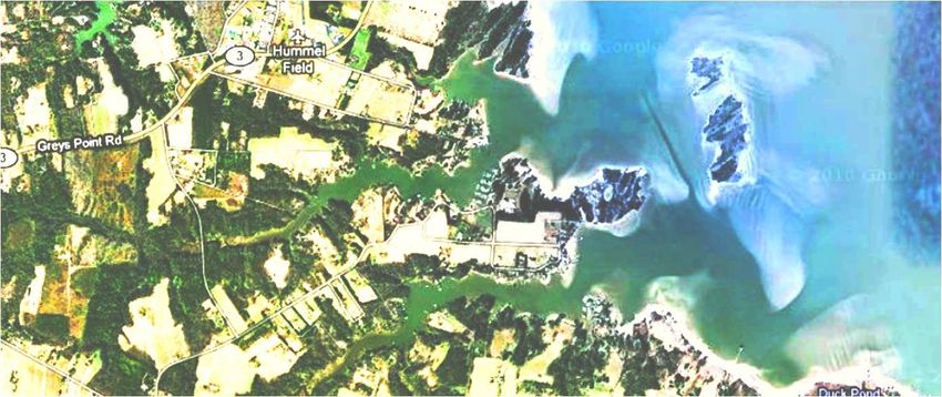
dredged material. Since overboard disposal Figure 2: Example of a bathymetric survey indicating the depth of
of dredged material into tidal waters is the Jackson Creek (Middlesex County) Channel. The red denotes
generally not permitted (VMRC Subaqueous the proposed dredged location parameters.
Guidelines Section III, E), applicants will
need to consider disposal areas that are acceptable to the various permitting agencies. Factors to consider for a
disposal site, include, but are not limited to the following (VMRC Subaqueous Guidelines Section III, C):
1. Encroachment into natural drainage ways;
2. Chemical nature of the dredged material and its potential for polluting adjacent or nearly underground
water supplies;
3. Encroachment over the underground utilities, ie. water lines and sewer facilities;
4. Value of the site to the natural environment;
5. Proximity to populated areas; and
6. Anticipated use of the material or disposal site after dredging material is placed and consolidated.
According to§10.1-704 of the Code of Virginia, the beaches of the Commonwealth (ie. beaches classified as
public) shall be given priority consideration as sites for the disposal of dredged material determined to be
suitable for beach nourishment for public benefit. The Secretary of Natural Resources shall have the
responsibility of determining if the dredged material is suitable for beach nourishment; however if a public
beach placement site is not suitable or available, dredged material may be placed on private beach, or in a
Page | 5private or public upland containment site. In general the regulatory and advisory agencies reach a decision on
the suitability of an area for beach nourishment.
Depending on the sediment disposal site, VMRC has associated royalties. Such royalties may be important in
determining the most feasible disposal site for the dredge project:
a. Public Beach –
If a public beach is chosen as the disposal site, fee simple and adjacent property owners may benefit from
the additional protection offered by the larger beach. VMRC requires a permit and charges an encroachment
royalty of $0.05 per square foot for placement of sandy dredge material over the adjacent State-owned
subaqueous lands (ie. area channelward of MLW). The placement of sandy dredge material on public or
private beaches, landward of MLW, is exempt from local wetlands boards. Permits may, however, be
required from the DEQ and the USACE.
b. Private Beach or Shoreline-
Applicants may have to work with fee simple and adjacent property owners to obtain an easement if the
proposed disposal site is a private beach or shoreline. If the private property owner is unwilling to relinquish
property rights to the applicant, then they will need to apply for permits to allow for the placement of the
dredge material on their property. Ideally the applicant and property owner will be co-applicants on the
VMRC JPA (see Section 3 for more information). VMRC has no jurisdiction landward of MLW; therefore,
there will never be a placement royalty assessed by VMRC for the disposal of dredge material above MLW.
The placement of sandy dredge material on public or private beaches, landward of MLW, is exempt from
local wetlands boards. Permits may, however, be required from the DEQ and the USACE. The placement of
dredge material on intertidal shorelines which do not meet the definition of a beach will require permits
from the local wetland board, DEQ and the USACE.
c. Private Upland Containment Site –
A containment site owned privately may be used for disposal of dredged material, particularly if the dredge
material is unsuitable for beach nourishment. The upland containment site acts as a permanent reserve for
dredged sediment and in some case acts as a holding location for dredged material to dry. Also in ideal
situations the upland containment site is not located within the Resource Protection Area1 (RPA).
d. Public Upland containment site –
A containment site owned by a public entity may be used for disposal of dredged material, if it is unsuitable
for beach nourishment. The upland containment site acts as a permanent reserve for dredged sediment and
in some case acts as a holding location for dredged material to dry. Also in ideal situations the upland
containment site is not located within the RPA.
Additionally as county wetland boards regulate the use and development of wetlands, the placement of dredged
material on public and private beach, and/or upland private or public containment site may fall in the
jurisdiction of the local Wetlands Board. Wetlands Boards within the Middle Peninsula have varying wetland
permit application fees and they each have varying degrees of experience in working with dredging projects.
Wetland Boards will receive the JPA application for review and within 45 days the Wetland Board will make
the notify the applicant if a wetland permit is required or not. Table 1 reviews the fee schedule for wetland
permits within the Middle Peninsula.
1
RESOURCE PROTECTION AREA (RPA): that component of the Chesapeake Bay Preservation Area comprised of lands adjacent to water
bodies with perennial flow that have an intrinsic water quality value due to the ecological and biological processes they perform or are sensitive to
impacts which may result in significant degradation to the quality of state waters (9VAC10-20-40).
Page | 6Table 1: Local Wetland Board Permit Fee Schedule
Contact for more
County Wetland Permit Fee information
Currently the county does not have fee schedule in place.
Essex However there a public hearing would be needed for the 804-443-4951
project.
Non-commercial/residential: $200
Commercial Projects: $300
Gloucester ▪ Includes cost of advertising the proposed project in public 804-963-1217
notice section of local newspaper
▪ permit valid for 1 year
Residential: $300
Commercial Projects: $400
▪ permit application needs to be submitted 6 weeks prior to
King &Queen Wetlands Board Meeting 804-785-5975
▪ permit valid for 18 months
▪ if project is exempt then there is still a $25 fee to review the
JPA
$300 Wetland Permit Fee (ie. flat rate) for Public Hearing
King William* 804-769-4969
and review by the Wetland Board
Single-User (private, non-commercial, residential): $150
Multi-User (commercial, community, industry, government): $200
Mathews After the fact Application – Double the application fee and 804-725-1624
subject to possible violation fees up to $10,000
-fees include advertising for public hearing paid by county
Private Use: $150
Commercial Use or community Use $250
Middlesex -fee includes cost of public hearing, the cost of advertising 804-758-3382
proposal in Southside Sentinel for two weeks and Wetland
Permits
4. Submission of the Joint Permit Application:
One of three parties, including a public entity (ie. political subdivision), private entity (ie. home owner, home
owner association), or a public private partnership, ma y request a dredging project. This request is made upon
the completion and submission of a Local/State/Federal Standard Joint Permit Application (JPA) (Appendix B)
to VMRC. Commission serves as the clearinghouse agency for the distribution of the JPA to the advisory and
regulatory agencies routinely involved in the review and permitting of dredge projects. This application must be
submitted for any and all projects which propose to impact to tidal and non-tidal shorelines and submerged
lands. This includes dredging projects, erosion control project, private or commercial piers, utility and road
crossings, etc. Upon receipt of a given application by all of these regulatory agencies, the JPA is concurrently
reviewed by the wetlands board, VMRC, USACE, and DEQ. Most dredge projects additionally are received by
the National Marine Fisheries Service (NMFS), the Environmental Protection Agency (EPA), the Virginia
Institute of Marine Science and possibly other State advisory agencies.
Page | 7In accordance with the Code of Virginia, VMRC assesses a permit fee of $25 for projects costing $10,000 or
less, and $100 for projects costing more than $10,000. Copies of the JPA may be obtained from the local
wetlands boards, VMRC, DEQ, USACE, or can be downloaded from the Norfolk District Corps of Engineers
web site at http://www.nao.usace.army.mil/technical%20services/Regulatory%20branch/Web2008StdJPA.pdf.
Agencies will review the JPA application and contact the applicant individually about additional permit
requirements for the project. As mentioned earlier each project is unique which requires unique consideration as
well as associated permits.
As the USACE has regulatory authority over Section 404 of the Clean Water Act (33 U.S.C. §1344), Section 10
of the Rivers Harbors Act of 1899 (33 U.S. C. §403), and Section 103 of the Marine Protection Research and
Sanctuaries Act (33 U.S.C. §1413), shallow water dredging projects may qualify for additional national and
regional permits. The USACE will notify the prospective permittee within 45 days of receiving the JPA
application whether the project may proceed under the nationwide permit or whether an individual permit is
required. If, after reviewing the notification, the District Engineer determines that the proposed activity would
have more than a minimal individual or cumulative adverse impact on the aquatic environment or otherwise
may be contrary to the public interest, the engineer will either condition the nationwide permit authorization or
reduce or eliminate the adverse impacts, or notify the prospective permittee the at the activity is not authorized
by the nationwide permit and provide the permittee with instruction on how to seek authorization under an
individual permit. The specifics of the projects will determine the type of permits required for the project, but
below is sample of permits that dredging project may require:
Nationwide Permit 3 Maintenance2: authorizes the removal of accumulated sediments and debris in the
vicinity of and within an existing structure and the placement of new or additional riprap to the structure.
The removal of sediment is limited to the minimum necessary to restore the waterway in the immediate
vicinity of the structure to the approximate dimensions that existed when the structure(s) was built but
cannot extend further than 200 feet in any direction from the structure.
Nationwide Permit 19 Minor Dredging3: authorizes dredging of no more than 25 cubic yards below the
plane of the ordinary high watermark or the mean high water mark from navigable waters of the United
States.
LOP-2 (Letter of Permission)4: authorizes dredging (channels and basins) for certain navigationally-related
recreational and commercial dredging projects, by either mechanical or hydraulic method, in waters of the
United States, within the geographical limits of the Commonwealth of Virginia under the regulatory
jurisdiction of the Norfolk District Corps, subject to the terms and conditions further set out herein.
To have questions answered about particular projects within the region please call the Northern Neck USACE
field office at 804-435-9362 or Gloucester County USACE field office at 804-642-5389.
As the Virginia Department of Environmental Quality administers the Virginia Water Protection (VWP) Permit
Program (§§ 62.1-44.15 and 62.1-44.15:20 of the Code of Virginia) for the Commonwealth, impacts to surface
waters such as land clearing, dredging, filling, excavation, draining or ditching in open water, streams and
2
For more details and a copy of the permit visit: www.nao.usace.army.mil/technical%20services/Regulatory%branch/NWP2007/NW-3.pdf
3
For more details and a copy of the permit visit: www.nao.usace.army.mil/technical%20services/Regulatory%20branch/NWP2007/NW-19.pdf
4
For more details and a copy of the permit visit: www.nao.usace.army.mil/technical%20services/Regulatory%20branch/08-LOP-Final/08-
LOP02%20Permit.pdf
Page | 8wetlands require such a permit. For maintenance dredging previously authorized, a regional permit 19 (RP-19)
may be required which does not does include a fee. However if it is determined that a permit from DEQ is
required, then the fee structure is based on the size of the area to be dredged, the amount of material to be
removed, the habitat of the area, and if the area is tidal or non-tidal. Since each project is case specific and such
things as avoidance and minimization of wetland impacts, and project purpose and need are all taken into
consideration it is best to call the DEQ Tidewater Regional Office for more details at (757) 518-2158.
Once the application has been approved by all of the regulatory agencies exerting jurisdiction, the permittee is
responsible for the project’s permit fees, associated dredging and placement royalties and/or mitigation costs.
With respect to VMRC, according to VA Code §28.2-1206 Section E, “All counties, cities and towns of the
Commonwealth shall pay the required permit fee but shall be exempt from all other fees;” such fees include
dredging and placement fees. For private applicants, dredging fees will apply while VMRC will consider the
dredging fees for private public partnerships on a case by case basis. The approved permit shall specify a
royalty which may not be less than $0.20 per cubic yard and no more than $0.60 per cubic yard. In establishing
the royalty, VMRC takes the following factors into consideration:
1. The primary and secondary purpose for removing the bottom material;
2. Whether the material has any commercial value and whether it will be used for any commercial purpose;
3. The use to be made of the removed material and public benefit or adverse effect upon the public that
will result from the removal or disposal of the material;
4. The physical characteristics of the material to be removed; and
5. The expense of removing and disposing of the material.
In most cases the applicant is charged $0.45 per cubic yard for dredged material, proposed to be removed from
State-owned bottom. If the dredged material is high quality and has the potential for commercial use, then the
applicant may be charged $0.60 per cubic yard.
As stated earlier, another factor contributing to the project’s associated dredging royalty is whether the project
is considered a maintenance dredge project or not. A maintenance dredge, as defined by VMRC, is a dredging
activity for navigation purposes that have been previously authorized by the Commission, to the depth
previously authorized by the Commission, and where a royalty, if applicable, has been previously paid to the
Commission for the initial removal State-owned submerged lands (Constitution VMRC Subaqueous Guidelines
Section II). Therefore if one’s project meets this definition the permittee is exempt from dredging royalties. If
the project is not considered maintenance then the permittee will be charged $0.20-$0.60 per cubic yard.
A permittee is also responsible for placement royalties. If the dredged sediment is placed below mean low tide
then the associated royalty is $0.05 per square foot. However to place dredged material above the mean low
water mark on private property, the private property owner may have to obtain a wetlands or coastal primary
sands dunes and beaches permit.
Ultimately the permittee is liable for the proper completion of the project, in particular closely adhering to all of
the permit conditions issued by the regulatory agencies. These include strict adherence to the maximum
permissible project depths, vegetated wetlands buffers, allowable dredge footprints and proper erosion and
sediment control at the dredge cut, pipeline or transfer route and dredge disposal site. The permittee is also
required to adhere to any regulations or laws that protect threatened and endangered species and other sensitive
habitats such as submerged aquatic vegetation or oyster reefs.
For a comprehensive overview of permit fees, dredging fees, and encroachment/placement fees associated with
dredging projects, please refer to the Table 3.
Page | 95. Selection of a contractor:
With the parameters for a dredged project approved by the appropriate regulatory agencies, the permittee seeks
bids from marine contractors and subcontractors capable of meeting the permits parameters.
6. Pre-dredging conference:
Often, as permit condition, a pre-dredging conference is held at the site prior to the commencement of
dredging.. The permittee, the dredging contractor, and a member of the VMRC staff must attend the
meeting. Other agencies may choose to participate. Held seven days prior to the commencement of dredging,
the conference includes an inspection of the dredge material containment area, an inspection of the previously
staked dredge area, and a discussion of the terms and conditions of the permit.
7. Dredging
Initiation of the dredge project commences only after all parties acknowledge that they understand the terms and
conditions of the permits issued.
8. Post-Dredge Bathymetric Survey:
The permittee will often be required to provide a post-dredging bathymetric survey of the dredged area within
30 days following dredging of the channel. The survey must be signed and dated as being accurate and true.
The survey must be referenced to mean low water and include a transect at the channelward end of the dredge
cut and at specified intervals along the dredged channel to the landward terminus of the dredged area. Accurate
bathymetric data from each transect shall be used to establish the top width of the dredge cut (± 1') and must
include a depth measurement exterior to both sides of the dredge cut. If applicable, the survey must also
indicate the horizontal distance between the top of the dredge cut and the vegetated wetlands depicted on the
project drawings.
9. VMRC Final Review:
VMRC is responsible for regulating activities on State-owned submerged land, tidal wetlands and
dunes/beaches pursuant to Chapters 12, 13, and 14, Subtitle III, of Title 28.2 of the Code of Virginia. Hence,
following dredging activities and receipt of the required post-dredge bathymetric survey, VMRC staff will
review the dredged activity to verify that it was completed in accordance with the terms and conditions of their
permit. The remaining permitting authorities will also review the project to insure project compliance with their
laws and regulations.
Page | 10Table 3: This matrix identifies sediment disposal options as well as the associated costs (ie. permit fees, dredging fees and royalties and encroachment fees) for entities interested in pursuing a maintenance or new dredging
project.
Type of Dredging Sediment Disposal Site Options Associated Costs
Dredging
Project Private Beach Public Upland Private Upland
Public
Applicant Maintenance New No Containment Containment Permit Fees Dredging fees and royalties Encroachment/Placement royalties
Beach Easement
easement Site Site
VMRC: Dredging Permit is $25, but
Public Entity if the cost of the project is to exceed
$10,000 the permit fee of $100 shall
be paid
Counties, Cities, and Towns are exempt
DEQ: will vary based on permit from all other dredging royalties
Public Entity requires (ie. Virginia Water
Counties, Cities and Towns are
Protection Permit)
exempt from all other dredging
USACE: individual permits may
require a fee up to $100 (case royalties
Public Entity sensitive); additional permits related
to a nationwide permit there are no Counties, Cities, and Towns are exempt
additional permit fees from all other dredging royalties
Public Entity Local Wetland Board: Wetland
Permit fees vary (Refer to Table 2)
VMRC: Dredging Permit is $25, but Exempt from all other fees and $0.05 / ft2 below MLW
Private Entity if the cost of the project is to exceed royalties due to being a maintenance and
$10,000 the permit fee of $100 shall dredging activity
be paid the applicant may have to pay legal fees
DEQ: will vary based on permit $0.20 - $0.60, per cubic yard ; in the to obtain an easement for placement on
Private Entity requires (ie. Virginia Water private property
majority of cases the fee is $0.45
Protection Permit)
USACE: individual permits may Exempt from all other fees and
Private Entity require a fee up to $100 (case royalties due to being a maintenance $0.05 / ft2 below MLW
sensitive); additional permits related dredging activity and
to mulit-user permits there are no private land owners may need to obtain
additional permit fees $0.20 - $0.60, per cubic yard ; in the a permit for beach nourishment along
Private Entity Local Wetland Board: Wetland and adjacent to private property
majority of cases the fee is $0.45
Permit fees vary (Refer to Table 2)
VMRC: Dredging Permit is $25, but Exempt from all other fees and
Public Private if the cost of the project is to exceed $0.05 / ft2 below MLW
royalties due to being a maintenance
Partnership $10,000 the permit fee of $100 shall and
dredging activity
be paid the applicant may have to pay legal fees
DEQ: will vary based on permit to obtain an easement for placement on
Public Private $0.20 - $0.60, per cubic yard ; in the
requires (ie. Virginia Water private property
Partnership Protection Permit) majority of cases the fee is $0.45
USACE: individual permits may
Exempt from all other fees and
Public Private require a fee up to $100 (case
sensitive); additional permits related royalties due to being a maintenance $0.05 / ft2 below MLW
Partnership
to mulit-user permits there are no dredging activity and
additional permit fees private land owners may need to obtain
Public Private Local Wetland Board: Wetland $0.20 - $0.60, per cubic yard ; in the a permit for beach nourishment along
Permit fees vary (Refer to Table 2) and adjacent to private property
Partnership majority of cases the fee is $0.45
Page | 11Additional Information:
The U.S. Army Corps of Engineers also has a primary responsible for the removal of debris from federally
maintained navigable channels and waterways. Section 202 of the Water Resources Develop Act of 1976
authorizes the USACE to remove debris from federally maintained commercial harbors and water areas
immediate adjunct thereto. Additionally the USACE is responsible for the removal of salvable vessels, marine
debris, and other obstruction from federally maintained navigable waterways under emergency conditions. In
the case that a waterway is obstructed by large pieces of debris, on a none emergency basis funds for removing
debris is limited for localities.
Added Value and Benefit:
As mentioned earlier an applicant has four general options to dispose of dredged material (ie. private beach,
public beach, public containment site and private containment site). However to add additional value to the
dredged material, which may benefit the public, Middle Peninsula localities could consider placing dredged
material at road endings to improve regional water access. Through past research, the Middle Peninsula
Chesapeake Bay Public Access Authority (PAA) identified over three hundred road endings within the Middle
Peninsula that could potentially yield access to public water. Additionally the PAA could work with neighbors
at these road ending sites to expand public beach or water access.
Conclusions:
Although dredging projects within the Tidewater Virginia have a general procedure to follow, each project
presents unique permitting requirements. Therefore as funding paradigm for shallow water projects is
anticipated to change from a primarily federally funded to a privately funded activity, private citizens and
public entities have a variety factors to consider in the future dredging of shallow draft channels; however
closely working with Virginia regulatory agencies involved with authorizing JPA may ease the permitting
process for shallow draft navigation projects and will ultimately help to keep channels open for navigation
within the region.
Page | 12Check List for Executing a Dredging Project
Identify channel with dredging need
Conduct a pre-dredge bathometric survey
Identify and select a location for disposal of dredged material
Apply for and receive the necessary permit via the submission of the Commonwealth Joint Permit
Application (Appendix A- JPA) and attend one or more required public meetings.
o Applicant name and address
o Detailed description of the proposed activity
o Map drawn to an appropriate and uniform scale – should include area of wetlands directly
affected, the location of the proposed work thereon, the area of existing and proposed fill
and excavation, the location width depth and length of any proposed channel and disposal
area, and the location of all existing and proposed structures, sewage collection and
treatment facilities, utility installations, roadways, and other related appurtenance of
facilities
o Description of the type of equipment to be used and the means of access to the activity site;
o Names and addresses of record of adjacent land and known claimants water rights in or
adjacent to the wetland of whom the applicant has notice
o Cost estimate
o Primary purpose of the project
o Secondary purpose of the proposed project
o Complete date of the measures to be taken during and after alternation to reduce detrimental
offsite effects;
o Completion date of the proposed work, project or structure
o Additional material and documentation as the wetlands board may require.
When Joint Permit Application is approved by the various regulatory agencies….
Put project out to bid and select a contractor
Conduct pre-dredging conference with representatives from the appropriate regulatory agencies and
the dredging contactor
Executive contract (ie. dredge channel and place dredged material)
Conduct post-dredge bathymetric survey
VMRC final review
Page | 13Appendix A: Glossary
Beach- the shoreline zone comprised of unconsolidated sandy material upon which there is mutual interaction
of the forces of erosion, sediment transport and deposition extending from the mean low water line landward to
where there is a marked change in either material composition or physiographic form such as a dune, bluff, or
marsh, or where no such change can be identified, to the line of woody vegetation (usually the effective limit of
storm waves), or the nearest impermeable manmade structure, such as a bulkhead, revetment, or paved road
(§28.2-1400 of the Code of Virginia).
Beach nourishment- placement of good quality sand along a beach shoreline to raise the elevation of the
nearshore area.(VIMS, 2006)
Beach of the Commonwealth- public beach
Joint Permit Application or JPA- The standard Joint Permit Application for shoreline stabilization structures
and other activities conducted in wetlands and the marine environment. The applicant completes one form and
submits to either local agency or VMRC, which is responsible for distributing to local, state and federal
permitting and advisory agencies (e.g. VIMS, Department of Game and Inland Fisheries, Department of
Conservation and Recreation, Department of Environmental Quality, U.S. Army Corps of Engineers). (VIMS,
2006)
Maintenance Dredging- is strictly defined by the VMRC as dredging activities for navigation purposes that
have been previously authorized by the Commission, to the depth previously authorized by the Commission,
and where a royalty has been previously paid to the Commission for the initial removal State-owned submerged
lands (Constitution of Virginia Article XI Section II)
Mean Lower Low Water- A tidal datum, a standard elevation defined by a certain phase of the tide The
average of the lower low water height of each tidal day observed over the National Tidal Datum Epoch (The
specific 19-year period adopted by the National Ocean Service as the official time segment over which tide
observations are taken and reduced to obtain mean values (e.g., mean lower low water, etc.) for tidal datums.)
For stations with shorter series, simultaneous observational comparisons are made with a control tide station in
order to derive the equivalent datum of the National Tidal Datum Epoch. (NOAA, 2011)
Mean low water -The average height of low waters over a nineteen year period. Virginia is a low water state,
meaning private property extends to the mean low water line. (VIMS, 2006)
Private beach- a beach, as defined by §28.2-1400 of the Code of Virginia, whose underlying fee (ownership)
is held privately and not by a local, state or federal governmental entity and whose public use is restricted or
controlled by the property owner.
Public beach- a sandy beach located on a tidal shoreline suitable for bathing in a county, city or town and open
to indefinite public use (Code of Virginia §10.1-705)
Royalties- fees paid to the Commonwealth for certain uses of submerged public lands. They are assessed in
addition to permit fees. All royalties are subject to change in accordance with the Commission's public
participation procedures and regulatory adoption process. Contact the Virginia Marine Resources Commission
Habitat Management Division for a current royalties schedule. (VMRC Subaqueous Guidelines Section I)
Page | 14You can also read


