Red-headed Woodpecker Habitat Mitigation Plan - MANITOBA INFRASTRUCTURE December 1, 2020
←
→
Page content transcription
If your browser does not render page correctly, please read the page content below
MANITOBA INFRASTRUCTURE

Red-headed Woodpecker Habitat
Mitigation Plan
December 1, 2020

TABLE OF CONTENTS

DISCLAIMER .......................................................................... III
PREFACE .............................................................................. IV
GLOSSARY OF TERMS AND ACRONYMS .......................................... VI

1.0 INTRODUCTION ............................................................. 1
   1.1 Background and Purpose ................................................................................................................... 1
   1.2 Project Overview................................................................................................................................ 1
   1.3 Project Interaction with Red-Headed Woodpecker Habitat ............................................................. 2

2.0 MITIGATION GOALS AND OBJECTIVES .............................. 3

3.0 PROJECT MITIGATION .................................................... 4
   3.1 General Project Mitigation Measures................................................................................................ 4
   3.2 Outlet Channel Right-of-way Habitat Mitigation .............................................................................. 4
  3.2.1 Revegetation Prescriptions .............................................................................................................. 4
  3.2.2 Nest Structure Mitigation ................................................................................................................ 5

4.0 MONITORING AND FOLLOW-UP......................................... 7
   4.1 Red-headed Woodpecker Nest Survey .............................................................................................. 7
   4.2 Nest Structure Survey ........................................................................................................................ 8
   4.3 Habitat Monitoring ............................................................................................................................ 9
  4.3.1 Adaptive Management .................................................................................................................... 9

5.0 REFERENCES ............................................................... 11

APPENDIX 1 ...................................................................... 13
   Figures .................................................................................................................................................... 13

APPENDIX 2 ...................................................................... 14
   Ancillary Information ............................................................................................................................. 14

                                                                                                                                                               i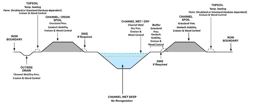
List of Figures
Figure 1: Schematic of LMOC ROW

                                                    ii
DISCLAIMER
This document was developed to support the Lake Manitoba and Lake St. Martin Outlet Channel
Environmental Management and Monitoring Program. This document has been prepared by Manitoba
Infrastructure as a way to share information and have discussion with Indigenous Communities and Groups
and the public. This document has been prepared using existing environmental and preliminary engineering
information, professional judgement as well as information from previous and ongoing public and Indigenous
engagement and consultation. The contents of this document are based on conditions and information
existing at the time the document was prepared and do not take into account any subsequent changes. The
information, data, recommendations, and conclusions in this report are subject to change as the information
has been presented as draft and will not be considered complete until further engagement and consultation
is complete. The plans may be further revised based on information and direction received from provincial
and federal environmental regulators. This draft report be read as a whole, and sections or parts should not
be read out of context.
iiiPREFACE
The Lake Manitoba and Lake St. Martin Permanent Outlet Channels Project (the “Project”) is proposed as a
permanent flood control mitigation for Lake Manitoba and Lake St. Martin to alleviate flooding in the Lake
St. Martin region of Manitoba. The Project includes the construction and operation of two new diversion
channels: the Lake Manitoba Outlet Channel (LMOC) will connect Lake Manitoba to Lake St. Martin and the
Lake St. Martin Outlet Channel (LSMOC) will connect Lake St. Martin to Lake Winnipeg. Associated with these
outlet channels is the development of bridges, control structures with power connections, a new realignment
of PR 239, and other ancillary infrastructure.
Manitoba Infrastructure (MI) is the proponent for the Project. After receipt of the required regulatory
approvals, MI will develop, manage, and operate the Project in accordance with the Environmental
Management Program (EMP). The EMP framework describes the environmental management processes that
will be implemented during the construction and operation phases of the Project. Components of the EMP
include a Wildlife Monitoring Plan and Revegetation Management Plan, both of which relate to the Red-
headed Woodpecker Mitigation Plan. The goal of the EMP is to ensure that the environmental protection
measures committed to in the Environmental Impact Statement (EIS) and the requirements of the
Environment Act Licence and Federal Decision Statement Conditions are undertaken in a timely and effective
manner. This includes the verification that environmental commitments are executed, monitored, and
evaluated for effectiveness, and that information is reported back in a timely manner to the Project
management team for adjustment if required.
Manitoba Infrastructure remains committed to ongoing engagement and consultation with Indigenous
groups and other stakeholders that are potentially affected by the Project. Detailed EMP review discussions
have been incorporated into community-specific consultation work plans and additional engagement
opportunities will be provided prior to EMP finalization. Engagement opportunities include virtual open
house events and EMP-specific questionnaires. EMP-specific questionnaires will be provided to Indigenous
groups and stakeholders to obtain feedback and views on the draft plans, in addition to exploring
opportunities for Indigenous participation in follow-up monitoring. Feedback and recommendations will be
used to inform the completion of the plans.
The EMP provides the overarching framework for the Construction Environmental Management Program
(CEMP) and the Operation Environmental Management Program (OEMP), which will be finalized as separate
documents prior to Project construction and ideally operation, respectively. Their finalization will consider
applicable conditions of the Environment Act Licence and associated approvals, any other pertinent findings
through the design and regulatory review processes and key relevant outcomes of the ongoing Indigenous
and public engagement and Consultation processes.
The purpose of the CEMP and OEMP is to guide how environmental issues will be addressed during
construction and operation, respectively, and how adverse effects of activities will be mitigated. The CEMP is
supported by several specific or targeted management plans (e.g., surface water, groundwater, sediment,
etc.), as shown in the Figure below, that will guide MI’s development of the Project’s contract documents and
subsequently, the Contractor(s) activities, in constructing the Project in an environmentally responsible
manner. The OEMP will likely include the same targeted plans developed to manage issues during
ivconstruction, but prior to construction completion they would be revised and adapted to suit the specific
needs during the operation phase. The purpose of the Red-headed Woodpecker Habitat Mitigation Plan is to
describe the habitat mitigation and monitoring activities that will be implemented along the LMOC right-of-
way for this species.
vGLOSSARY OF TERMS AND ACRONYMS
Acronyms
EIS environmental impact statement
HMA habitat mitigation area
LMOC Lake Manitoba outlet channel
LSMOC Lake St. Martin outlet channel
PDA Project Development Area
PR Provincial Road
RVMP Revegetation Management Plan
ROW right-of-way
viINTRODUCTION
1.0 INTRODUCTION
1.1 Background and Purpose
The Lake Manitoba and Lake St. Martin Outlet Channels Project (hereafter the Project) proposed by
Manitoba Infrastructure (MI) overlaps potential critical habitat for red-headed woodpecker (Melanerpes
erythrocephalus), listed as endangered under the federal Species at Risk Act (Government of Canada 2019).
Red-headed woodpecker is a cavity-nesting woodpecker that breeds in open deciduous forest or forest
edges, and open habitats (e.g., grasslands or pastures containing windrows) where mature or dead trees are
available for nesting (COSEWIC 2007, ECCC 2019). In 2019, a federal recovery strategy was proposed to
provide guidance aimed at halting and reversing the population decline of red-headed woodpecker and
identifying critical habitat (ECCC 2019).
The recovery strategy identifies 10 x 10 km critical habitat squares throughout this species’ Manitoba range
(ECCC 2019). These standardized spatial units are used to identify known areas containing confirmed
breeding evidence and potential critical habitat. The Project overlaps with one of these squares along the
Provincial Road (PR) 239 realignment west of the Lake Manitoba Outlet Channel (LMOC; ECCC 2019;
Appendix 1, Figure 1). Construction within the Project Development Area (PDA; i.e., Project footprint) will
require clearing of forested habitats that may support red-headed woodpecker habitat but not critical habitat
as defined in this species recovery strategy (ECCC 2019; Section 1.3).
Despite no evidence that critical breeding habitat will be directly affected by the Project, MI is using a
precautionary approach and committing to additional mitigation measures (as described in Chapter 12.7 of
the Environmental Impact Statement [EIS]), to reduce potential Project-related effects to red-headed
woodpecker habitat.
The purpose of this Red-headed Woodpecker Habitat Mitigation Plan (hereafter called the Plan) is to describe
the red-headed woodpecker habitat mitigation and monitoring activities that will be implemented along the
LMOC outlet channel right-of-way (ROW).
1.2 Project Overview
The Project will develop a permanent flood control mitigation system for Lake Manitoba and Lake St. Martin
for alleviating flooding in the Lake St. Martin region. This will be accomplished through construction of a new
outlet channel from Lake Manitoba to Lake St. Martin (LMOC) and a new outlet channel from Lake St. Martin
to Lake Winnipeg (Lake St. Martin Outlet Channel [LSMOC]). These new channels will allow for floodwaters to
be moved more quickly through Lake Manitoba and Lake St. Martin into Lake Winnipeg. The Project will
result in less flooding and reduced lake levels on Lake St. Martin. Other works include re-alignment of PR 239
and a hydroelectric distribution line for operation of the Lake St. Martin Outlet Channel outlet structure
(Appendix 1, Figure 1).
Manitoba Infrastructure
1
Red-headed Woodpecker Habitat Mitigation Plan | Draft /Rev AINTRODUCTION
1.3 Project Interaction with Red-Headed Woodpecker Habitat
The Project (i.e., part of the PR 239 realignment ROW) overlaps 35.4 ha of the 20,000-ha critical habitat
square (0.2%); 19.8 ha of which is open deciduous forest, a preferred broad habitat type for red-headed
woodpecker. Existing land cover data indicates that the Project will result in the direct loss of 1.7 ha of old
growth (41-80 years) deciduous forest, which suggests the potential loss of decadent trees (potential red-
headed woodpecker nest trees) may be minor. Point count surveys completed in 2020 did not reveal the
presence of the species where the PR 239 realignment overlaps the critical habitat square (WSP 2020).
Additionally, based on Environment and Climate Change Canada data, the only red-headed woodpecker
critical habitat polygons known to occur within the LAA are located greater than 600 m from the PR 239
realignment (ECCC pers. comm. 2020). The Project is not expected to interact with these known critical
habitat polygons because of the distance between them. The combination of these data suggests that the
Project does not interact with critical habitat.
Manitoba Infrastructure
2
Red-headed Woodpecker Habitat Mitigation Plan | Draft /Rev AMITIGATION GOALS AND OBJECTIVES
2.0 MITIGATION GOALS AND OBJECTIVES
The goal of this Plan is to enhance breeding habitat opportunities for red-headed woodpecker along the
LMOC ROW. This will be achieved by employing the mitigation measures, best management practices, and
adaptive management techniques outlined in this Plan during the construction and operation phases of the
Project.
Specific objectives are to:
• Describe revegetation prescriptions (i.e., shrub plantings) and vegetation management practices that
provide habitat opportunities for red-headed woodpecker, while adhering to requirements for the safe
operation and maintenance of the Project;
• Describe LMOC ROW habitat mitigation, including erecting salvaged snags and/or decadent trees and
artificial nest structures; and
• Describe how revegetation prescriptions and nest structure occupancy by red-headed woodpecker will
be monitored to verify the effectiveness of mitigation measures.
Manitoba Infrastructure
3
Red-headed Woodpecker Habitat Mitigation Plan | Draft /Rev APROJECT MITIGATION
3.0 PROJECT MITIGATION
3.1 General Project Mitigation Measures
Construction of the outlet channels will require clearing of the 400 m-wide ROW and parts of the PR 239
realignment ROW, but mitigation measures outlined in the Environmental Protection Plan (MI 2020a) will
reduce potential effects to red-headed woodpecker and their habitats. These include:
• Treed habitats within the ROW will be retained where safe and technically feasible to do so.
• Clearing will not occur between April 1 and August 31 to avoid disturbance to nesting birds and other
wildlife (ECCC 2018).
• If clearing is scheduled to occur within the nesting period (April 1 to August 31), a nest survey may be
undertaken by a qualified wildlife biologist if warranted. In the event an active nest is found, it will be
subject to site-specific mitigation measures (i.e., clearly marked protective buffer around the nest
and/or non-intrusive monitoring).
• Adhering to the provincially recommended setback distance for vegetation clearing and construction
activities of 200 m from an active red-headed woodpecker nest between April 15 to August 15 (MB CDC
2015).
To promote establishment of a healthy vegetation cover for the Project and to allow for the proper function
of water flow the following measures are part of the maintenance program during the operations phase:
• Maintenance of the vegetation cover in areas where erosion might be present;
• Ongoing mowing of the outside drain to promote drainage and berms to support geotechnical stability
that requires no tree cover; and
• Ongoing weed control.
3.2 Outlet Channel Right-of-way Habitat Mitigation
Habitat mitigation for red-headed woodpecker includes both revegetation prescriptions (and subsequent
maintenance during the operation phase, as outlined in the Revegetation Management Plan [RVMP; MI
2020b]) and nest structure replacement.
3.2.1 Revegetation Prescriptions
The goal of the RVMP is to revegetate upland areas of the outlet ROWs in a manner that promotes the
establishment of grassland communities consisting of native and agronomic grasses and forbs along LMOC
(MI 2020b). To protect structural integrity and maintain hydrological function, shrubs and trees are
discouraged from growing along the channel and on spoil piles/berms but are acceptable at the base of spoil
piles in peripheral areas of the ROW (Appendix 1, Figure 2). Figure 1 identifies where shrubland prescriptions
may be added to a schematic cross section of LMOC. Revegetation prescriptions involving native shrub
plantings will provide habitat for wildlife including red-headed woodpecker as this species nests in open
deciduous forests and forages in open grassland and shrubland habitat (Appendix 2). For the purposes of this
Manitoba Infrastructure
4
Red-headed Woodpecker Habitat Mitigation Plan | Draft /Rev APROJECT MITIGATION
Plan, red-headed woodpecker habitat mitigation areas (HMAs) are those areas where shrub plantings are
planned in the upland portions of the LMOC ROW (i.e., adjacent to the channel berms and in areas of the
ROW that lie adjacent to deciduous forest habitats [Figure 1; Appendix 1, Figures 2 and 3).
Native plant species will be used to revegetate the LMOC ROW where possible, including native shrubs within
the HMAs. The ROW outside of the HMAs will be revegetated with herbaceous plant species only (e.g., native
grasses; see RVMP [MI 2020b]). Revegetation activities will occur in spring or fall depending on the
construction schedule and if applied in the fall, prescriptions may require adjustments to improve
survivability of seed during winter for herbaceous cover (see RVMP [MI 2020b]).
Figure 1: Schematic of LMOC ROW
Figure 1 schematic illustrates the main components of the LMOC ROW. The HMAs will be located between
the ROW boundary and outside edge of the outside drain (as shown on the left of the diagram) and between
the ROW boundary and outside edge of the channel soil berm or topsoil berm (as shown on the right of the
diagram).
3.2.2 Nest Structure Mitigation
Red-headed woodpecker habitat will be enhanced using nest structure mitigation that incorporates the
salvage and installation of snags and decadent trees and the addition of artificial nest structures which are
described in greater detail below.
Salvaged Decadent Trees
Decadent trees, including known nest trees, will be salvaged during ROW clearing and stored off-site until
construction has been completed. As described in the EPP (MI 2020), tree salvage will occur in areas of
modeled red-headed woodpecker habitat from the EIS (Appendix 1, Figure 1), or other areas of the PDA
determined to contain suitable snags and/or decadent trees, which will be identified and flagged by the
Manitoba Infrastructure
5
Red-headed Woodpecker Habitat Mitigation Plan | Draft /Rev APROJECT MITIGATION
environmental monitor prior to clearing. Salvaged trees will include snags and decadent deciduous trees ≥18
cm in diameter at breast height or those that have dead or dying limb(s) with a diameter ≥13 cm at breast
height (ECCC 2019).
Salvaged snags and decadent trees will be installed prior to the addition of the above-described vegetation
prescriptions in a subset of HMAs where adjacent open deciduous forest habitats provide potential red-
headed woodpecker breeding habitat. The number and size of HMAs and the habitat adjacent to the PDA will
be reviewed prior to plan finalization to determine how and where mitigation would be applied. Measures to
reduce the likelihood of decadent trees falling over include adherence to best management practices (e.g.,
attaching decadent trees to treated wooden posts; NRCS 2008) and integrity monitoring (Section 4.2).
Artificial Nesting Structure
Artificial nesting structures will provide cavities for nesting red-headed woodpecker by installing wooden
nest boxes in the HMAs within the ROW adjacent to where mature deciduous forest habitats occur. Artificial
nesting structures will be installed following the addition of the above-described vegetation prescriptions in a
subset of HMAs where adjacent open deciduous forest habitats are potential red-headed woodpecker
breeding habitat. Nest boxes, known to be used by woodpecker species (e.g., McComb and Noble 1981)
including red-headed woodpeckers (e.g., Grabber and Grabber 1977, Kale II and Maehr 1990), will be
constructed and installed in a manner that is consistent with published natural cavity and site characteristics.
This includes nest box installation at a height of 7-12 m above ground (cavity direction is unimportant) in a
shaded location and construction of interior dimensions of approximately 30 cm deep (vertically), 11 cm
wide, and 11 cm deep (horizontally) with a cavity entrance of 6 cm in diameter (Belson 1998, CWF 2020, Frei
et al. 2020). Artificial nesting structure development will also follow additional guidance from published
instructions on the construction and maintenance of nest boxes (CWF 2020).
Manitoba Infrastructure
6
Red-headed Woodpecker Habitat Mitigation Plan | Draft /Rev AMONITORING AND FOLLOW-UP
4.0 MONITORING AND FOLLOW-UP
To assess the effectiveness of the implementation of this Plan, monitoring activities within the HMAs will
include a red-headed woodpecker nest survey and an associated habitat survey which are described in
greater detail below.
4.1 Red-headed Woodpecker Nest Survey
Rationale
Mitigation measures have been incorporated into the design of the outlet channels to provide habitat
enhancements for wildlife, including red-headed woodpecker. The red-headed woodpecker nest survey will
be used to assess the effectiveness of these mitigation measures by examining the habitat use in the HMAs.
Objective
The objective of the red-headed woodpecker survey is to understand if red-headed woodpeckers occupy
salvaged decadent trees and artificial nesting structures placed within or adjacent to the HMAs.
Measurable Parameter
The measurable parameter for the red-headed woodpecker nest survey is habitat occupancy of salvaged
decadent trees or artificial nesting structures by breeding red-headed woodpecker.
Design
Within the HMAs, red-headed woodpecker surveys will occur at all HMAs where salvaged decadent trees or
artificial nesting structures have been installed.
Methods
The red-headed woodpecker survey will follow a standardized ten-minute point-count survey protocol (Ralph
et al. 1995) that incorporates a call-broadcast component shown to increase the detection probability for
woodpecker species (e.g., BC RIC 1999, Baumgardt et al. 2013, Wisconsin DNR 2013). The sequence of calls
will use a five-minute passive listening/viewing period, followed by a three-minute active call-broadcast
period (rotation between 30 seconds of red-headed woodpecker calls and drumming and 30 seconds of
silence), and completed with a two-minute passive listening/viewing period. Surveys will be conducted during
periods of suitable weather (i.e., clear visibility, wind ≤20 km/h, temperature >0°C, and precipitation not
exceeding a light, intermittent drizzle) and start at sunrise and ending no later than 4.5 hours after sunrise
(Bibby et al. 2000).
Surveys will be completed on two separate occasions, between June 1 to 30 (COSEWIC 2007), using a
removal sampling design (i.e., once the species is detected at a site, it is not re-surveyed) which will meet the
objectives outlined above while also providing a framework for ongoing monitoring efforts.
Manitoba Infrastructure
7
Red-headed Woodpecker Habitat Mitigation Plan | Draft /Rev AMONITORING AND FOLLOW-UP
The resulting data will be summarized by HMA and mapped relative to the Project to provide an
understanding of the presence and distribution of red-headed woodpecker and in relation to mitigation
measures.
Frequency
The red-headed woodpecker nest survey will be completed twice during the peak breeding period described
above. Surveys will be undertaken during 1-6 post-construction.
Decision Trigger / Threshold for Action
Decision trigger(s) and adaptive management action(s) will be developed in consultation with the regulator
and Indigenous and stakeholder input.
A summary of the monitoring criteria for red-headed woodpecker is provided in Table 1.
4.2 Nest Structure Survey
Rationale
Mitigation measures have been incorporated into the design of the outlet channels to provide habitat
enhancements for wildlife, including red-headed woodpecker. The nest structure survey will be used to
assess the effectiveness of these mitigation measures by monitoring the structural integrity of salvaged
decadent trees and artificial nest boxes.
Objective
The objective of the nest structure survey is to understand if the salvaged decadent trees and artificial
nesting structures placed within or adjacent to the HMAs remain structurally sound and available for
breeding red-headed woodpecker.
Measurable Parameter
The measurable parameter for the nest structure survey is a pass/fail for nest structure integrity and
availability.
Design
The nest structure surveys will occur at all HMAs where salvaged decadent trees or artificial nesting
structures have been installed.
Methods
The nest structure survey will use visual confirmation by a qualified biologist to assess whether the salvaged
decadent trees and artificial structures are structurally sound and available (i.e., they remain in place and
upright). Notable structural concerns or losses will be reported to MI immediately. The assessment of each
structure will include detailed documentation of the findings and photographs.
Manitoba Infrastructure
8
Red-headed Woodpecker Habitat Mitigation Plan | Draft /Rev AMONITORING AND FOLLOW-UP
Frequency
The nest structure survey will be completed once per year prior to the breeding season (April 1). Surveys will
be undertaken during years 1-6 post-construction.
Decision Triggers / Thresholds for Action
Over 25% of salvaged decadent trees have compromised structural integrity or have become unavailable.
• Action: Consider replacing the salvaged trees or replacing them with artificial nesting structures and
report survey results to Manitoba Conservation and Climate regional wildlife biologist/manager
through annual data reports.
Over 25% of artificial nesting structures have compromised structural integrity or have become unavailable.
• Action: Consider adding new artificial nesting structures and report survey results to Manitoba
Conservation and Climate regional wildlife biologist/manager through annual data reports.
A summary of the monitoring criteria for the red-headed woodpecker is provided in Table 1.
Table 1: Monitoring Criteria for the Red-headed Woodpecker Nest Survey
Monitoring Monitoring
Method Project Phase Duration Frequency
Objective Metric
Evaluate the Twice during
Red-headed Years 1 to 6
effectiveness of Species the peak
woodpecker Operation post-
mitigation occurrence breeding
nest survey construction
measures for period
red-headed
woodpecker Once prior
Structure Years 1 to 6
Nest structure to the
availability and Operation post-
survey breeding
integrity construction
period
4.3 Habitat Monitoring
Habitat monitoring will be undertaken as part of the monitoring activities outlined in the RVMP (MI 2020b)
for the LMOC (Section 8) and LSMOC (Section 14).
4.3.1 Adaptive Management
Adaptive management is a structured and systematic process focused on improving environmental
management by using lessons learned to reduce uncertainty while updating policies and practices (British
Columbia Ministry for Forests and Range 2015). Adaptive management allows for the flexibility to identify
and implement new mitigation measures or to modify existing ones (CEA Agency 2015).
Manitoba Infrastructure
9
Red-headed Woodpecker Habitat Mitigation Plan | Draft /Rev AMONITORING AND FOLLOW-UP
Adaptive management will be incorporated into the habitat monitoring described above and as part of the
adaptive management process outlined in the RVMP (Section 9; MI 2020b). As part of the adaptive
management process, the ability of salvaged decadent trees to satisfy the intended goals and objectives will
be evaluated. If salvaged decadent trees are assessed as ineffective based on these criteria, a root cause
analysis of why a measure failed to meet the intended objective will be conducted. This type of analysis helps
to prevent similar future failures, but also encourages critical thinking and documentation as part of
continued learning.
Manitoba Infrastructure
10
Red-headed Woodpecker Habitat Mitigation Plan | Draft /Rev AREFERENCES
5.0 REFERENCES
Baumgardt, J., J. Sauer, and K. Nicholson. 2013. Occupancy modeling of woodpeckers: maximizing detections
for multiple species with multiple spatial scales. Journal of Fish and Wildlife Management 5(1):198–207.
BC RIC (British Columbia Resource Inventory Committee). 1999. Inventory methods for woodpeckers.
Standards for components of British Columbia’s biodiversity No. 19. Available at:
https://www2.gov.bc.ca/assets/gov/environment/natural-resource-stewardship/nr-laws-
policy/risc/woodml20.pdf?bcgovtm=CSMLS. Accessed November 2020.
Belson, M. S. 1998. Red-headed woodpecker (Melanerpes erythrocephalus) use of habitat at Wekiwa Springs
State Park, Florida. Master's Thesis, Univ. of Central Florida, Orlando.
Bibby, C.J., N.D. Burgess, D.A. Hill, and S. Mustoe. 2000. Bird census techniques. Second edition. Academic
Press, London.
British Columbia Ministry of Forests and Range. 2015. Defining Adaptive Management [online]. Available
from: https://www.for.gov.bc.ca [accessed October 2020].
CEA Agency (Canadian Environmental Assessment Agency). 2015. Practitioners glossary for the
environmental assessment of designated projects under the Canadian Environmental Assessment Act, 2012
[online]. Available from: https://www.canada.ca/en/impact-assessment-agency/services/policy-
guidance/practitioners-glossary-environmental-assessment-designated-projects-under-canadian-
environmental-assessment-act-2012.html [accessed October 2020].
COSEWIC (Committee on the Status of Endangered Wildlife in Canada). 2007. COSEWIC assessment and
update status report on the red-headed woodpecker (Melanerpes erythrocephalus) in Canada. Committee on
the Status of Endangered Wildlife in Canada. Ottawa, ON, ON. vi+ 27 pp.
CWF (Canadian Wildlife Federation). 2020. Build and maintain nesting and roosting boxes. Available at:
https://cwf-fcf.org/en/resources/DIY/habitat-projects/map-your-backyard/build-and-maintain-nesting.html.
Accessed November 2020.
ECCC (Environment and Climate Change Canada). 2018. General nesting periods of migratory birds. Available
at: https://www.canada.ca/en/environment-climate-change/services/avoiding-harm-migratory-
birds/general-nesting-periods/nesting-periods.html. Accessed November 2020.
ECCC. 2019. Recovery strategy for the red-headed woodpecker (Melanerpes erythrocephalus) in Canada
[Proposed]. Species at Risk Act Recovery Strategy Series. Environment and Climate Change Canada, Ottawa.
viii + 118 pp.
Frei, B., K. G. Smith, J. H. Withgott, P. G. Rodewald, P. Pyle, and M. A. Patten. 2020. Red-headed woodpecker
(Melanerpes erythrocephalus), version 1.0. In Birds of the World (P. G. Rodewald, Editor). Cornell Lab of
Ornithology, Ithaca, NY, USA. https://doi.org/10.2173/bow.rehwoo.01
Manitoba Infrastructure
11
Red-headed Woodpecker Habitat Mitigation Plan | Draft /Rev AREFERENCES
Government of Canada. 2020. Species at risk public registry. Available at:
https://www.canada.ca/en/environment-climate-change/services/species-risk-public-registry.html. Accessed
November 2020.
Kale II, H. W. and D. S. Maehr. 1990. Florida's birds: a handbook and reference. Sarasota, FL: Pineapple Press.
MB CDC (Manitoba Conservation Data Centre). 2015. Recommended development setback distances from
birds. Available at: https://www.gov.mb.ca/sd/pubs/conservation-data-centre/mbcdc_bird_setbacks.pdf.
Accessed November 2020.
McComb, W.C., and R.E. Noble. 1981. Nest-box and natural-cavity use in three mid-south forest habitats.
Journal of Wildlife Management 45: 93-101.
MI (Manitoba Infrastructure). 2020a. Lake Manitoba Lake St. Martin Outlet Channels Project: Environmental
Protection Plan (Draft November 2020). Manitoba Infrastructure, Winnipeg, MB.
MI (Manitoba Infrastructure). 2020b. Lake Manitoba Lake St. Martin Outlet Channels Project: Revegetation
Management Plan (Draft November 2020). Manitoba Infrastructure, Winnipeg, MB.
Natural Resources Conservation Service (NRCS) 2008. Artificial Nesting structures. Available at:
http://cecentralsierra.ucanr.edu/files/124138.pdf
Ralph, C. John; Sauer, John R.; Droege, Sam, technical editors. 1995. Monitoring Bird Populations by Point
Counts. Gen. Tech. Rep. PSW-GTR-149. Albany, CA: Pacific Southwest Research Station, Forest Service, US.
Department of Agriculture; 187 p.
Wisconsin DNR. 2013. Red-headed woodpecker (Melanerpes erythrocephalus) species guidance. Available at:
https://dnr.wi.gov/files/PDF/pubs/er/ER0702.pdf. Accessed November 2020.
WSP. 2020. Lake Manitoba and Lake St. Martin Outlet Channel Project Preconstruction Environmental Field
Work – Wildlife (Cons15843).
Manitoba Infrastructure
12
Red-headed Woodpecker Habitat Mitigation Plan | Draft /Rev AAPPENDIX 1
Figures
Figure 1: Project Overview Map
Figure 2: LMOC Red-headed Woodpecker Habitat Mitigation Areas
Figure 3: LMOC Red-headed Woodpecker Habitat Mitigation Areas (SAMPLE)
Manitoba Infrastructure
13
Red-headed Woodpecker Habitat Mitigation Plan | Draft /Rev A!
!
!
!
!
!
!
!
! V
U
513
DAUPHIN RIVER
FIRST NATION & NAC
¯
($ $
Kinwow Bay
Provincial Park
6
³
² !!
!
!!!
Sturgeon
!
!
!!
! ! !! !!
! !
!
!
Bay
!
!
!
!
!
! !
!
!
!
!
!
!
Gypsumville
!
WMA
!
!
!
Lake
!
!
!
St.Martin
!
!
!
Outlet
!
Sturgeon Bay
!
Channel
!
Gypsumville
Provincial
Park
!
.
4
!
LAKE ST. MARTIN
!
V
U
328
V
U
513
FIRST NATION
!
!
LITTLE
!
SASKATCHEWAN
FIRST NATION
!
!
!
Lake
!
St.Martin
!
!
PINAYMOOTANG
!
FIRST NATION
!
!
!
!
!
Hilbre
!
WMA
!
Hilbre
!
.
4
!
!
!
Steep
!
Rock 4.
!
Faulkner
Grahamdale
!
.
4 Mantagao Lake
G:\_GIS_Project_Folder\111475120\figures_EMPs\Wildlife\RHWO_Offsetting_Plan\111475120_R007_REVA_Wildlife_RHWP_Offset_Plan_Overview_Critical Habitat.mxd
V
U
239 WMA Project Development Area Components
!
WMA
Grahamdale
!
.
4 Project Development Area (PDA)
!
Proposed PR 239 Realignment
!
Lake
!
Proposed Bridge
Manitoba
!
6
³
²
Lake Outlet Proposed Water Control Structure
!
Channel
!
Modelled Red-headed Woodpecker
Breeding Habitat
!
Manitoba Moosehorn .
4
!
.
4
V
U
237 Red-headed Woodpecker
!
Critical Habitat within 10 x 10km
!
Watchorn Standardized UTM Squares
!
Bay
Assessment Area
!
Watchorn
!
Wildlife Local Assessment Area (LAA)
Provincial
!
Park Wildlife Regional Assessment Area (RAA)
! ! ! ! !
!
!
!
!
Ashern
V
U 325
!
.
4
!
0 7.5 15
Moosehorn
!
km
!
WMA
!
1:450,000
!
!
!
!
!
Legend
!
!
Fairford Water Control Structure Existing Distribution Line Northern Affairs Community (NAC)
!
!
! !
!
Lake St.Martin Emergency Outlet! Planned Distribution Line First Nation
!
MANITOBA INFRASTRUCTURE
!
! !
Channel (Reach 1) Lake Manitoba & Lake St.Martin Outlet Channels Project
Provincial Highway (PTH/PR) Wildlife Management Area
!
!
Lake St.Martin Access Road
!
!
Municipal Road Provincial Park Project Overview Map
!
! !
Existing Transmission Line
!
Notes
!
1. Coordinate System: NAD 1983 UTM Zone 14N
2. Data Sources: Governments of Manitoba and Canada, Manitoba Infrastructure, Environment and Climate Change Canada
DRAFT Figure 1
!
3. Last Update: 11/30/2020 10:28:48 AM
!
!
!
!Lake
Hilbre
Enis
Lake
St.Martin ¯
(
$ $
6
³
²
Clarks
Lake
Faulkner
V
U 239
Goodison
Lake
Grahamdale
Lake
Manitoba
Outlet
Channel
Clear
Lake
Reed
Lake
G:\_GIS_Project_Folder\111475107_Lak eManitobaOutlet\Arc Map\Revegetation\MI_LMOC_Red-headedWoodpec ker_Habitat_Mitigation_Areas_20201126.mxd
Project Components
Outlet Channel
Proposed PR 239 Realignment
Rendalls Proposed Bridge
Creek
Proposed Water Control Structure
Moosehorn
Habitat Mitigation Area
V
U
237
Red-headed woodpecker Habitat
Lake Watchorn Mitigation Area
Watchorn
Manitoba Provincial
Bay Park 0 2.5 5
km
DRAFT Newman 1:125,000
Lake
Legend
! !
Existing Transmission Line
Provincial Highway (PTH/PR) MANITOBA INFRASTRUCTURE
Lake Manitoba & Lake St.Martin Outlet Channels Project
Municipal Road
Provincial Park LMOC Red-headed woodpecker
Habitat Mitigation Areas - Overview
Notes
1. Coordinate System: NAD 1983 UTM Zone 14N
2. Data Sources: Governments of Manitoba and Canada, Manitoba Infrastructure
DRAFT Figure 2
3. Last Update: 11/26/2020 11:24:37 AMNW-32-28-8-W
SW-32-28-8-W
NE-32-28-8-W
NW-29-28-8-W
Revised: 2020-11-30 By: ACampigotto
G:\_GIS_Project_Folder\111475107_LakeManitobaOutlet\ArcMap\Revegetation\MI_LMOC_Red-headedWoodpecker_Habitat_Mitigation_Areas_GridExample_20201123.mxd
Ã
Æ
6
SE-32-28-8-W
NE-29-28-8-W
NW-33-28-8-W
SW-33-28-8-W
DRAFT
Legend
LAKE À
¾ 239 Outside Drain - 30m buffer Project Components Habitat Mitigration Area 0 100 200
metres
MANITOBA
Top of Dike buffer Proposed Bridge Red-headed Woodpecker Habitat (At original document size of 11x17)
Mitigation Area 1:5,000
Channel ROW Boundary
1 2 3 4 5 6 7 8 9 Prepared by AC on 2020-11-30
$
Project Location
10 Top of Channel TR by LW on 2020-11-30
(
Near Lake Manitoba & Lake St.Martin
11 12
¯
Manitoba
Channel Centerline
$
Client/Project 111475107
13 MANITOBA INFRASTRUCTURE
Ã
Æ
6 Channel / Drain Spoil Piles
Lake Manitoba & Lake St.Martin Outlet Channels Project
Channel
À
¾237 LAKE Figure No. DRAFT - FOR DISCUSSION
ST. MARTIN Quarter Sections Figure 3 PURPOSES ONLY
Notes Title
1. Coordinate System: NAD 1983 UTM Zone 14N
2. Data Sources: Government of Manitoba, Stantec Consulting, Hatch, EcoLogic
LMOC Red-headed Woodpecker
3. Background: Air photo courtesy of MI
*Ground truthing required for confirmation of wetland areas (some wetlands on the map may
Habitat Mitigation Areas (SAMPLE)
not actually exist, or, some existing wetlands may not be identified on the map)
Disclaimer: This document has been prepared based on information provided by others as cited in the Notes section. Stantec has not verified the accuracy and/or completeness of this information and shall not be responsible for any errors or omissions which may be incorporated herein as a result. Stantec assumes no responsibility for data supplied in electronic format, and the recipient accepts full responsibility for verifying the accuracy and completeness of the data.APPENDIX 2
Ancillary Information
Biophysical Attributes of Critical Habitat for Red-headed Woodpecker
In 2018, a federal recovery strategy (proposed) was developed to provide guidance aimed at halting and
reversing the population decline of red-headed woodpecker and identifying critical habitat (ECCC 2019). The
biophysical attributes of critical habitat in which red-headed woodpecker individuals may carry out breeding
(e.g., courtship, territory defense, nesting, and post-fledgling), roosting, and foraging activities in Canada
include (as per ECCC 2019, pg. 33):
1) “potential nesting/roosting structures: decadent deciduous trees that are 18 cm dbh [diameter at
breast height] or more or have dead or dying limb(s) with a diameter of 13 cm or more;
2) habitat that is located up to 190 m from the dripline (i.e., edge of canopy) of the decadent trees
described under 1).
a) Treed areas for breeding, roosting, and foraging, including:
• In Saskatchewan and Manitoba: sparsely treed woodlands such as those dominated by aspen
with some elm and oak; bluffs (clumps or grove of trees) with an open or grazed understory
located within pasture, crop fields, farm yards, and urbanized areas; hedgerows and
shelterbelts with mature and decadent elm, maple and/or ash trees, and; sparsely treed
riparian habitat with aspen, cottonwood, and oak.
• Understory vegetation within treed areas;
• Fruit- and mast-bearing trees/bushes to provide food sources; and
• Coarse woody debris within treed areas.
b) Other non-built-up areas containing vegetation that supports food sources and that are located
up to 50 m from the dripline of a decadent tree described under 1) and/or the edge of habitat
described under 2a). Habitat types may include, but are not limited to, the following examples:
• Pastures
• Grasslands
• Old fields
• Wetlands
• Shrublands.”
Manitoba Infrastructure
14
Red-headed Woodpecker Habitat Mitigation Plan | Draft /Rev AYou can also read


