GEOTILL Inc - Bid Room FTP Site for General Contractors
←
→
Page content transcription
If your browser does not render page correctly, please read the page content below
GEOTILL Inc.
Geotechnical Engineering Subsurface Exploration Construction Testing and Material Engineering
GEOTECHNICAL ENGINEERING INVESTIGATION
Proposed Dairy Queen Grill & Chill
655 West Main Street
Lebanon, KY 40033
GEOTILL Project No. 112126402
Prepared For:
Double Seven Development
7101 West 78th Street
Minneapolis, MN 55439
Attn: Ms. Christy L. Eastman
Paralegal
February 12, 2021
7732 Loma Court
Fishers Indiana 46036
Ph. 317-449-0033 Fax 317- 285-0609 (info@geotill.com)
Geotechnical and Construction Materials Testing Professionals
Indiana • Illinois • Michigan • Ohio • Kentucky • Missouri • Connecticut • Delaware • Florida • Georgia • Idaho•
Iowa • Kansas • Maine • Maryland • Mississippi • New Hampshire • North Carolina • North Dakota • Oklahoma•
Pennsylvania • Rhode Island • Vermont • West Virginia • Wisconsin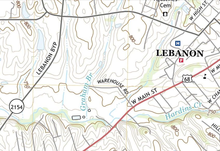
7732 Loma Court
Fishers, Indiana 46038
Phone 317.449.0033
Fax 317.285.0609
www.geotill.com
Geotechnical Engineering Subsurface Exploration Construction Testing and Material Engineering
February 12, 2021
Double Seven Development
7101 West 78th Street
Minneapolis, MN 55439
Attention: Ms. Christy L. Eastman
Paralegal
Re: Geotechnical Engineering Investigation
Proposed Dairy Queen Grill & Chill
655 West Main Street
Lebanon KY, 42728
GEOTILL Project No. 112126402
Gentlemen:
Submitted herewith is the report of our geotechnical engineering investigation for the above
referenced project. This study was authorized in accordance with Proposal Agreement No. 01041121
dated January 22, 2021.
This report contains the results of our field and laboratory testing program, an engineering
interpretation of this data with respect to the available project characteristics, and recommendations
to aid in the design and construction of foundations and other earth-connected phases of this project.
We wish to remind you that we will store the samples for 30 days, after which time they will be
discarded unless you request otherwise.
We appreciate the opportunity to be of service to you on this project. If we can be of any further
assistance, or if you have any questions regarding this report, please do not hesitate to contact either
of the undersigned.
Sincerely,
GEOTILL INC.
Fawzy Ezzein Malek Smadi
Fawzy Ezzein, Ph.D., P.E. Malek Smadi, Ph.D., P.E.
Project Engineer Principal Engineer
(317) 449-0033 Ext. 101
Copies: (1) Double Seven Development, Attn: Ms. Christy L. Eastman
Indiana • Illinois • Michigan • Ohio • Kentucky • Missouri • Connecticut • Delaware • Florida • Georgia • Idaho•
Iowa • Kansas • Maine • Maryland • Mississippi • New Hampshire • North Carolina • North Dakota • Oklahoma•
Pennsylvania • Rhode Island • Vermont • West Virginia • Wisconsin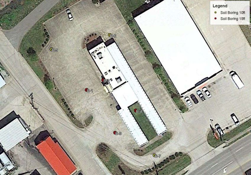
TABLE OF CONTENTS

                                                                                                                                 Page

1.0 PURPOSE AND SCOPE ----------------------------------------------------------------------------------------------------- 1
2.0 PROJECT CHARACTERISTICS -------------------------------------------------------------------------------------------1
3.0 GENERAL SUBSURFACE CONDITIONS ------------------------------------------------------------------------------2
  3.1       Subsurface Soil Conditions -------------------------------------------------------------------------------------------2
  3.2       Ground Water -----------------------------------------------------------------------------------------------------------3
4.0 SUMMARY OF FINDINGS AND RECOMMENDATIONS ----------------------------------------------------------3
  4.1       Footings------------------------------------------------------------------------------------------------------------------ 3
  4.2       Floor Slabs --------------------------------------------------------------------------------------------------------------5
  4.3       Pavement ----------------------------------------------------------------------------------------------------------------5
  4.3.1     Asphalt Pavement ------------------------------------------------------------------------------------------------------7
  4.3.2     Concrete Pavement -----------------------------------------------------------------------------------------------------7
  4.4       Site Grading -------------------------------------------------------------------------------------------------------------8
5.0 GENERAL CONSTRUCTION PROCEDURES AND RECOMMENDATIONS -----------------------------------8
  5.1       Site Preparation ---------------------------------------------------------------------------------------------------------9
  5.2       Fill Compaction---------------------------------------------------------------------------------------------------------9
  5.3       Foundation Excavations --------------------------------------------------------------------------------------------- 10
  5.4       Construction Dewatering -------------------------------------------------------------------------------------------- 11
  5.5       Construction Monitoring -------------------------------------------------------------------------------------------- 11
6.0 FIELD INVESTIGATION ------------------------------------------------------------------------------------------------- 12
7.0 LABORATORY INVESTIGATION ------------------------------------------------------------------------------------- 12
8.0 LIMITATIONS OF STUDY ----------------------------------------------------------------------------------------------- 12
APPENDIX ------------------------------------------------------------------------------------------------------------------------ 14
GEOTECHNICAL ENGINEERING INVESTIGATION
                               Proposed Dairy Queen Grill & Chill
                                     655 West Main Street
                                      Lebanon, KY 40033
                                 GEOTILL Project No. 112126402

                               1.0 PURPOSE AND SCOPE

The purpose of this study was to determine the general subsurface conditions at the project
site by drilling seven test borings and to evaluate this data with respect to foundation concept
and design for the construction of a 2,232 square foot restaurant facility in Lebanon,
Kentucky. Also included is an evaluation of the site with respect to potential construction
problems and recommendations dealing with earthwork and quality control during
construction.

                         2.0 PROJECT CHARACTERISTICS

The development of a new Dairy Queen restaurant is planned on a site located 655 West
Main Street, Lebanon, Kentucky. It has been reported that the development of the new
restaurant will take place on the northeast corner of the West Main Street and Warehouse
Road intersection on an approximately +/-0.86 acres. The project will consist of the
construction of a single story 2,232 square foot restaurant facility. There is currently a
closed Sonic Drive-In located on the property, which will be demolish. The general
location of the project site is shown on Figure 1 in the Appendix. The ground surface at
the site is characterized as relatively flat and is primarily asphalt and concrete covered.

The proposed structure will be designed as a spread footing foundation. Parking lots and
access drives are currently constructed in the proposed area of the structure. The location
of the site is shown on Figure 2 in the Appendix.

                                                                                February 12, 2021
                                                                                           Page 1
Geotechnical Engineering Investigation
Proposed Dairy Queen Grill & Chill
Lebanon, KY
GEOTILL Project No. 112126402
Details regarding structural loads are not available at this time; however, for the purpose
of this study, it has been assumed that the maximum column, wall, and floor loads will not
exceed about 100 kips/column, 3 kips/lin.ft. and 200 lbs./sq.ft, respectively.
3.0 GENERAL SUBSURFACE CONDITIONS
3.1 Subsurface Soil Conditions
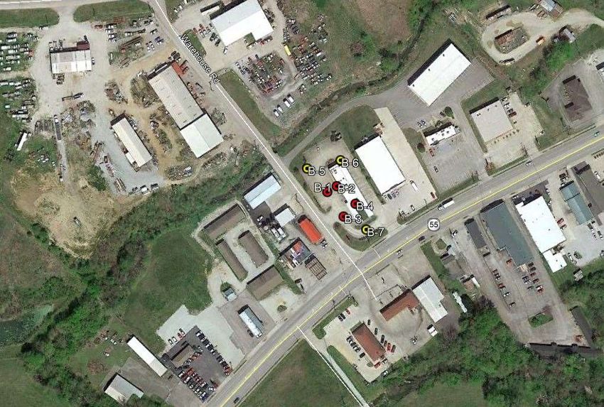
The general subsurface conditions were investigated by drilling four (4) soil test borings to
a depth of 15 ft around the perimeter of the existing building and three (3) soil test borings
to a depth of 10 feet in the area of the proposed pavement field at the locations shown on
the Boring Plan (Figure 2 in the Appendix). The subsurface conditions disclosed by the
field investigation are summarized in the following paragraphs. Detailed descriptions of
the subsurface conditions encountered in each test boring are presented on the test boring
logs in the Appendix. The letters in parentheses following the soil descriptions are the soil
classifications in general accordance with the Unified Soil Classification System. It should
be noted that the stratification lines shown on the soil boring logs represent approximate
transitions between material types. In-situ stratum changes could occur gradually or at
slightly different depths.
The surface material of each borehole consisted of 6 to 9 inches of concrete overlying the
subsurface soils. Soil test boring B-4 contained 7 inches of topsoil. Samples collected
from soil test borings contained a medium stiff to hard Silty Clay (CL) with varying
amounts of gravel. Refusal was encountered at a depth of 4 to 10 feet when a weathered
black shale was encountered. The consistency of the cohesive soils and the density of the
cohesionless soils were estimated based upon the results of the standard penetration test
(ASTM D-1586).
February 12, 2021
Page 2
Geotechnical Engineering Investigation
                                                                Proposed Dairy Queen Grill & Chill
                                                                                      Lebanon, KY
                                                                   GEOTILL Project No. 112126402

3.2     Ground Water
Ground water observations were made during the drilling operations by noting the depth of
water on the drilling tools and in the open boreholes following withdrawal of the drilling
augers. Free ground water was not observed during field investigation activities. It should be
noted that short-term ground water readings in the test borings are not usually a reliable
indication of the actual ground water level and that fluctuations in the level of the ground
water should be expected due to variations in rainfall and other factors.

           4.0 SUMMARY OF FINDINGS AND RECOMMENDATIONS

The following findings and recommendations have been developed on the basis of the
previously described project characteristics (Section 2.0) and subsurface conditions (Section
3.0). If there is any change in these project criteria, including project location of the site, a
review should be made by this office.

4.1     Footings
Our findings show that any additional structure or building can be supported on shallow
spread footings provided that any unsuitable materials are identified and removed at the
proposed footing locations. Footings that bear on firm natural soil (or on well-compacted
engineered fill that is placed over firm natural soil) can be designed for a net allowable soil
pressure of 2,500 lbs/sq.ft for both column (square type) and wall (strip type) footings. It is
important that the soil at the base of each footing excavation be carefully inspected as
described in Section 5.3 to ensure that pockets of soft natural soils and any uncontrolled fill
materials or any remains from previous construction are identified and removed from beneath
the footings and that the footings will bear on suitable materials.

                                                                                  February 12, 2021
                                                                                             Page 3
Geotechnical Engineering Investigation
                                                                Proposed Dairy Queen Grill & Chill
                                                                                      Lebanon, KY
                                                                   GEOTILL Project No. 112126402

In using net pressure, the weight of the footing and backfill over the footing, including the
weight of the concrete slab, need not be considered; hence, only loads applied at or above the
finished area need to be used for dimensioning the footings. Wall footings should be at least
2 ft. wide and column footings should be at least 3 ft. wide for bearing capacity considerations.

All exterior footings and footings in unheated areas should be located at a depth of at least 3
ft. below the final exterior grade for frost protection.

Provided that the footings are designed as prescribed herein and inspected as outlined in
Section 5.3, it is estimated that the total and differential foundation settlements should not
exceed about 1 in. and 1/2 in., respectively. Careful field control will contribute substantially
to minimizing the settlements.

Based on geologic mapping and the results of the soil borings, the subsurface conditions at
this site most nearly approximate Site Class C based on the International Building Code.

Lateral forces on a shallow spread footing can be resisted by the passive lateral earth pressure
against the side of the footing and by friction between the subgrade soil and the base of the
footing. An allowable passive pressure of 500 lbs/sq.ft can be used for that portion of the
footing that is below a depth of 2.5 ft. below the final exterior grade (no portion of the footing
above this depth should used for lateral resistance). An allowable coefficient of friction
(between the base of the footing and the underlying soil) of 0.3 can be used in conjunction
with the minimum downward load on the base of the footing.

Uplift forces on the footings can be resisted by the weight of the footings and the soil material
that is placed over the footings. It is recommended that the soil weight be limited to that
immediately above and within the perimeter of the footings (unless a much higher factor of
safety is used). A total soil unit weight of 110 lbs/cu. ft. can be used for the backfill material

                                                                                  February 12, 2021
                                                                                             Page 4
Geotechnical Engineering Investigation
                                                              Proposed Dairy Queen Grill & Chill
                                                                                    Lebanon, KY
                                                                 GEOTILL Project No. 112126402

above the footings, provided it is compacted as recommended in Section 5.2. It is also
recommended that a factor of safety of at least 1.3 be used for calculating uplift resistance
from the footings (provided only the weight of the footing and the soil immediately above it
are used to resist uplift forces).

4.2     Floor Slabs
Floor slabs can be supported on firm existing soils or on compacted structural fill. The slab
subgrade should be prepared and inspected as described in Section 5.1 of this report. Due
to the uncontrolled fill existing below the floor slabs in some locations, the existing soils
shall be inspected carefully, making sure that any soft pockets of uncontrolled fill or soft
natural soils are identified and removed.

It is recommended that all floor slabs be "floating," that is, fully ground supported and not
structurally connected to walls or foundations. This is to minimize the possibility of
cracking and displacement of the floor slabs because of differential movements between
the slab and the foundation. Although the movements are estimated to be within the
tolerable limits for structural safety, such movements could be detrimental to the slabs if
they were rigidly connected to the foundations.

It is furthermore recommended that the floor slab be supported on a 6 in. layer of relatively
clean granular material such as sand and gravel or crushed stone. This is to help distribute
concentrated loads and equalize moisture conditions beneath the slab. Provided that a
minimum of 6 in. of granular material is placed below the slab, a modulus of subgrade
reaction (k30) of 125 lbs/cu.in. can be used for design of the floor slabs.

4.3     Pavement
Based on the results of classification tests and our experience with similar soils, a
California Bearing Ratio (CBR) value of 3 has been estimated for use in pavement design

                                                                                February 12, 2021
                                                                                           Page 5
Geotechnical Engineering Investigation
                                                                Proposed Dairy Queen Grill & Chill
                                                                                      Lebanon, KY
                                                                   GEOTILL Project No. 112126402

for the silty clay (CL) subgrade soils encountered at this site. The subgrade soils should be
prepared and inspected as described in Sections 5.1 and 5.2 of this report.

Details regarding site grading in pavement areas are not available at this time; however,
depending upon grading requirements and seasonal conditions, it is likely that the pavement
subgrade in some areas will be wet, soft or yielding at the time of construction. If at the time
of construction, the subgrade is found to be excessively wet, soft, or yielding, it is
recommended that the subgrade soils be stabilized by disking, aerating, and recompacting.
However, if it is not possible to improve the subgrade soils in this manner because of weather
conditions, scheduling, or other conditions (which is often the case), it is recommended that
the subgrade soils be stabilized / modified either by using hydrated lime, by using a geogrid
with additional crushed stone placed over the subgrade, or by removal and replacement of the
unstable soils. The best method for stabilizing the pavement subgrade should be determined
in the field at the time of construction based upon the actual field conditions in conjunction
with the specific soil type encountered at the locations requiring stabilization, the size of the
areas requiring stabilization and the construction schedule.

The pavement subgrade surface should be uniformly sloped to facilitate drainage through the
granular base and to avoid any ponding of water beneath the pavement. The storm water catch
basins in pavement areas should be designed to allow water to drain from the aggregate base
into the catch basins. At a minimum, subsurface trench drains should be included that extend
out at least 20 ft. from the catch basins.

The following report sections outline recommendations for asphalt and concrete pavements
for automobile parking areas and truck zones. It is important to note that the recommendations
for the automobile parking areas are based on the assumption that these areas will not be
subject to any heavy truck traffic. Therefore, in areas where truck traffic cannot be controlled
(i.e., driveways), it is suggested that the thicker pavement section be utilized.

                                                                                    February 12, 2021
                                                                                               Page 6
Geotechnical Engineering Investigation
Proposed Dairy Queen Grill & Chill
Lebanon, KY
GEOTILL Project No. 112126402
4.3.1 Asphalt Pavement
Based on a CBR value of 3, a design period of 20 years, normal traffic for this type of facility
and the conditions encountered at the site, the following asphalt pavement sections are
recommended:
Automobile Parking Areas 3 in. of asphaltic concrete over 6 in. of granular
base.
Driveway Areas 4.5 in. of asphaltic concrete over 10 in. of granular
and Truck Zones base.
The base should be a well-graded crushed stone with a maximum of 10 percent (by weight)
finer than the No. 200 sieve. The asphaltic concrete pavement should be constructed in
accordance with the INDOT Standard Specifications Section 402-Hot Mix Asphalt, HMA,
Pavement.
4.3.2 Concrete Pavement
Concrete pavement thicknesses were determined from methods developed by the Portland
Cement Association (PCA), the American Association of State Highway and Transportation
Officials (AASHTO), and the American Concrete Institute (ACI). These methods assume
that the subgrade is firm, well-compacted, and non-pumping and that all joints are properly
designed, located, and sealed to minimize moisture inflow to the subgrade. It is also important
to ensure that proper concrete curing practices will be employed and that traffic will not be
allowed until the concrete has had sufficient time to cure.
For design calculation purposes, the compressive strength of the concrete was assumed to be
4,000 lbs./sq.in. (or a modulus of rupture of about 625 lbs./sq.in.). The modulus of subgrade
reaction (k30) was estimated to be 125 lbs./cu.in.
February 12, 2021
Page 7Geotechnical Engineering Investigation
Proposed Dairy Queen Grill & Chill
Lebanon, KY
GEOTILL Project No. 112126402
Based on the above information, the following concrete pavement sections were determined:
Automobile Parking Areas 5 in. of concrete over a well-compacted,
non-pumping subgrade.
Driveway Areas 8 in. of concrete over a well-compacted,
and Truck Zones non-pumping subgrade.
The performance of the concrete paving section is highly dependent on controlling the
pumping of the subgrade soils. Although no wet surface soils were noted at the time of this
study, it is important that surface drainage be controlled to prevent water from ponding in
pavement areas.
4.4 Site Grading
Adequate drainage should be provided at the site to minimize any increase in moisture content
of the foundation soils. The exterior grade should be sloped away from the structure to prevent
ponding of water.
5.0 GENERAL CONSTRUCTION PROCEDURES
AND RECOMMENDATIONS
It is possible that variations in the subsurface conditions will be encountered during
construction. Although only minor variations that can be readily evaluated and adjusted for
during construction are expected, it is recommended that the geotechnical engineer or a
qualified soils technician be retained to perform continuous inspection and review during
construction of the earth-related phases of the work. This will permit correlation between the
test boring data and the actual subsurface conditions encountered during construction.
February 12, 2021
Page 8Geotechnical Engineering Investigation
Proposed Dairy Queen Grill & Chill
Lebanon, KY
GEOTILL Project No. 112126402
5.1 Site Preparation
All areas that will support concrete slabs and pavements should be properly prepared. After
rough grade has been established in cut areas, and prior to placement of fill in all fill areas,
the exposed subgrade should be carefully inspected by the geotechnical engineer or a qualified
soils technician by probing and testing as needed. Any soft soil, soft zones of fill or other
organic material, and other undesirable materials still in place, frozen, or wet, should be
removed. All loose sandy soils should be compacted. The exposed subgrade should
furthermore be inspected by proof-rolling with suitable equipment to check for pockets of soft
material hidden beneath a thin crust of better soil. Any unsuitable materials thus exposed
should be removed and replaced with well-compacted, engineered fill as outlined in Section
5.2.
Care should be exercised during the grading operations at the site. Due to the nature of the
near-surface soils, the traffic of construction equipment may create pumping and general
deterioration of the shallower soils, especially if excess surface water is present. The grading,
therefore, should be done during a dry season, if at all possible.
5.2 Fill Compaction
All engineered fill beneath floor slabs, footings, and pavements should be compacted to a dry
density of at least 98 percent of the standard Proctor maximum dry density (ASTM D-698).
The compaction should be accomplished by placing the fill in about 8 in. (or less) loose lifts
and mechanically compacting each lift to at least the specified minimum dry density. Field
density tests should be performed on each lift as necessary to ensure that adequate moisture
conditioning and compaction is being achieved.
Compaction of any fill by flooding is not considered acceptable. This method will generally
not achieve the desired compaction and the large quantities of water will tend to soften the
foundation soils.
February 12, 2021
Page 9Geotechnical Engineering Investigation
Proposed Dairy Queen Grill & Chill
Lebanon, KY
GEOTILL Project No. 112126402
All native soils encountered in the test borings made at this site are considered suitable as
general fill material. The need for some aeration or modification of the more clayey soils
should be expected before they can be placed and compacted to the specified density.
5.3 Foundation Excavations
The soil at the base of each footing excavation should be inspected by a geotechnical
engineer or a qualified soils technician to ensure that all loose, soft, or otherwise
undesirable material is removed at footing locations and that the footing will bear on
satisfactory material. At the time of such inspection, it will be necessary to make hand
auger borings or use a hand penetration device in the base of the footing excavation to
ensure that the soils below the base are satisfactory for support of the footing. The soils
should be probed to a minimum depth of 3 ft. below the bottom-of-footing elevation.
Where undercutting is required to remove unsuitable materials and it is inconvenient to
lower the footing, the proposed footing elevation may be re-established by backfilling after
all undesirable materials have been removed. The undercut excavation beneath each
footing should extend to suitable bearing soils. The dimensions of the excavation base
should be determined by imaginary planes extending outward and downward on a 2
(vertical) to 1 (horizontal) slope from the base perimeter of the footing (see Figure 3 in the
Appendix). The entire excavation should then be refilled with engineered fill. The
engineered fill should be limited to well-graded sand and gravel or crushed stone
compacted to the minimum dry density recommended in Section 5.2; or flowable fill or
lean concrete may be used. Special care should be exercised to remove any sloughed,
loose, or soft materials near the base of the excavation slopes. In addition, special care
should be taken to "tie-in" the compacted fill with the excavation slopes with benches as
necessary. This is to ensure that no pockets of loose or soft materials will be left in place
along the excavation slopes below the foundation bearing level.
February 12, 2021
Page 10Geotechnical Engineering Investigation
Proposed Dairy Queen Grill & Chill
Lebanon, KY
GEOTILL Project No. 112126402
Soils exposed in the bases of all satisfactory foundation excavations should be protected
against any detrimental change in condition such as from disturbance, rain and freezing.
Surface run-off water should be drained away from the excavation and not allowed to pond.
If possible, all footing concrete should be placed the same day the excavation is made. If
this is not practical, the footing excavations should be adequately protected.
5.4 Construction Dewatering
Based upon the ground water data obtained during drilling operations, it appears that
dewatering is not required for the excavations during construction. In cases where cohesive
soils are encountered in the base of excavations, it is expected that such dewatering can
probably be handled by conventional dewatering methods such as pumping from sumps.
However, more extensive dewatering will be required where silty or sandy soils are
encountered in the base of the excavation. The best dewatering system for each case must be
determined at the time of construction based upon actual field conditions.
5.5 Construction Monitoring
We recommend that a GEOTILL geotechnical engineer or designee be retained to
continuously evaluate and test the subgrade and footing excavations before forming and
placing steel or concrete. If the soils upon which the footings are to be constructed become
soft or disturbed, or if unsuitable materials are encountered, these materials should be removed
and replaced with acceptable structural fill or as directed by the engineer.
Concrete strength and consistency tests should also be carried out, in accordance with the
project specifications.
February 12, 2021
Page 11Geotechnical Engineering Investigation
Proposed Dairy Queen Grill & Chill
Lebanon, KY
GEOTILL Project No. 112126402
6.0 FIELD INVESTIGATION
Seven (7) test borings were drilled at the locations shown on the Boring Plan (Figure 2 in the
Appendix). The seven soil test boring were extended to a depth of 4 to 10 ft in the investigated
area. Split-spoon samples were obtained by the standard penetration test procedures (ASTM
D-1586) at 2.5 ft intervals to a depth of 10 ft below the existing ground, and at 5.0 ft intervals
elsewhere.
Logs of the borings showing visual descriptions of all soil strata encountered using the
Unified Soil Classification System are included in the Appendix. Ground water
observations, sampling information, and other pertinent field data and observations are also
included. In addition, a sheet defining the terms and symbols used on the log and
explaining the standard penetration test procedure is provided immediately following the
boring log.
7.0 LABORATORY INVESTIGATION
The disturbed samples were inspected and classified in accordance with the Unified Soil
Classification System and the boring log was edited as necessary. To aid in classifying the
soils and to determine general soil characteristics, natural moisture content tests were
performed on selected samples. The results of these tests are included on the boring logs.
8.0 LIMITATIONS OF STUDY
An inherent limitation of any geotechnical engineering study is that conclusions must be
drawn on the basis of data collected at a limited number of discrete locations. The
recommendations provided in this report were developed from the information obtained
from the test boring which depicts the subsurface conditions only at the specific boring
February 12, 2021
Page 12Geotechnical Engineering Investigation
Proposed Dairy Queen Grill & Chill
Lebanon, KY
GEOTILL Project No. 112126402
location and at the particular time designated on the log. Soil conditions at other locations
may differ from conditions occurring at this boring location. The nature and extent of
variations may not become evident until the course of construction. If variations then
appear evident, it will be necessary to re-evaluate the recommendations of this report after
performing on-site observations during the excavation period and noting the characteristics
of any variation.
Our professional services have been performed, our findings obtained and our
recommendations prepared in accordance with generally accepted geotechnical
engineering principles and practices. This warranty is in lieu of all other warranties either
expressed or implied. This company is not responsible for the independent conclusions,
opinions or recommendations made by others based on the field exploration and laboratory
test data presented in this report. The scope of our geotechnical engineering services does
not include any environmental assessment or investigation for the presence or absence of
hazardous or toxic materials in the soil, ground water or surface water within or beyond
the site studied.
February 12, 2021
Page 13APPENDIX
Figure 1 - Vicinity Map (a-b)
Figure 2 - Boring Plan (a-b)
Figure 3 - Design Illustration - Footings in
Undercut Areas
Test Boring Logs
"Field Classification System for Soil Exploration"FIGURE NO. 1a – VICINITY MAP
Project: Proposed Dairy Queen Grill & Chill
655 West Main Street
Lebanon, KY 40033
Scale: NTS
GEOTILL PROJECT#
112126402
DATE: February 12, 2021 CLIENT: DOUBLE SEVEN DEVELOPMENTSITE
FIGURE NO. 1b – VICINITY MAP
Project: Proposed Dairy Queen Grill & Chill
655 West Main Street
Lebanon, KY 40033
Scale: NTS
GEOTILL PROJECT#
112126402
DATE: February 12, 2021 CLIENT: DOUBLE SEVEN DEVELOPMENTFIGURE NO. 2a– BORING MAP
Project: Proposed Dairy Queen Grill & Chill
655 West Main Street
Lebanon, KY 40033
Scale: NTS
GEOTILL PROJECT#
112126402
DATE: February 12, 2021 CLIENT: DOUBLE SEVEN DEVELOPMENTFIGURE NO. 2b– BORING MAP
Project: Proposed Dairy Queen Grill & Chill
655 West Main Street
Lebanon, KY 40033
Scale: NTS
GEOTILL PROJECT#
112126402
DATE: February 12, 2021 CLIENT: DOUBLE SEVEN DEVELOPMENTFIGURE NO. 3 – DESIGN ILLUSTRATION
FOOTINGS IN UNDERCUT AREA
Project: Proposed Dairy Queen Grill & Chill
655 West Main Street
Lebanon, KY 40033
Scale: NTS
GEOTILL PROJECT#
DATE: February 12, 2021 CLIENT: DOUBLE SEVEN DEVELOPMENT
1121264027732 Loma Ct TEST BORING LOG
Fishers, IN 46038
317 449 0033
Fax 317 285 0609
CLIENT Double Seven Development BORING # B-1
PROJECT NAME Dairy Queen - Lebanon JOB # 112126402
PROJECT LOCATION 655 West Main Street Latitude, 37.563889, -85.267189
Longitude
Lebanon KY 40033
DRILLING and SAMPLING INFORMATION TEST DATA
Date Started 1/29/21 Hammer Wt. 140 lbs.
Date Completed 1/29/21 Hammer Drop 30 in.
Drill Foreman A. Hammon Spoon Sampler OD 2.0 in.
Standard Penetration Test,
Blows per 6 in. Increments
Inspector J Brodowski Rock Core Dia. -- in.
Pocket Penetrometer
Moisture Content, %
HSA --
Recovery Graphics
Boring Method Shelby Tube OD in.
Sampler Graphics
Sample Type
Groundwater
SOIL CLASSIFICATION
Remarks
Depth, ft
Scale, ft
Stratum
Sample
PP-tsf
Depth
SURFACE ELEVATION
No.
Concrete 6" 0.5
Gravel FIll 6" 1.0
1 SS 4-7-9 23.2
Dark Brown to Black, very moist, very stiff, Silty Clay
(CL) trace rock fragments (weathered shale)
2 SS 8-7-8 24.4 2.25
5
6.0
Gray, very moist, stiff to hard, Silty Clay (CL) trace 3 SS 5-7-7 28.4 1.5
medium gravel
4 SS 6-10-50/3"
10.0
10
End of boring 10' - Refusal
15
Sample Type Depth to Groundwater Boring Method
SS - Driven Split Spoon Noted on Drilling Tools Dry ft. HSA - Hollow Stem Augers
ST - Pressed Shelby Tube At Completion Dry ft. CFA - Continuous Flight Augers
CA - Continuous Flight Auger CA - Casing Advancer
RC - Rock Core
After -- hours -- ft.
MD - Mud Drilling
CU - Cuttings Cave Depth 8.5 ft. HA - Hand Auger
CT - Continuous Tube Page 1 of 17732 Loma Ct TEST BORING LOG
Fishers, IN 46038
317 449 0033
Fax 317 285 0609
CLIENT Double Seven Development BORING # B-2
PROJECT NAME Dairy Queen - Lebanon JOB # 112126402
PROJECT LOCATION 655 West Main Street Latitude, 37.563928, -85.267105
Longitude
Lebanon KY 40033
DRILLING and SAMPLING INFORMATION TEST DATA
Date Started 1/29/21 Hammer Wt. 140 lbs.
Date Completed 1/29/21 Hammer Drop 30 in.
Drill Foreman A. Hammon Spoon Sampler OD 2.0 in.
Standard Penetration Test,
Blows per 6 in. Increments
Inspector J Brodowski Rock Core Dia. -- in.
Pocket Penetrometer
Moisture Content, %
HSA --
Recovery Graphics
Boring Method Shelby Tube OD in.
Sampler Graphics
Sample Type
Groundwater
SOIL CLASSIFICATION
Remarks
Depth, ft
Scale, ft
Stratum
Sample
PP-tsf
Depth
SURFACE ELEVATION
No.
Concrete 9"
0.8
Gravel FIll 6" 1.3
1 SS 7-12-14 16.0 3.5
Gray to Brown, moist, very stiff, Silty Clay (CL) trace
medium gravel
3.5
Black, moist, hard, Silty Clay (CL) 4.0 2 SS 10-50/3"
End of boring 4' - Refusal
5
10
15
Sample Type Depth to Groundwater Boring Method
SS - Driven Split Spoon Noted on Drilling Tools Dry ft. HSA - Hollow Stem Augers
ST - Pressed Shelby Tube At Completion Dry ft. CFA - Continuous Flight Augers
CA - Continuous Flight Auger CA - Casing Advancer
RC - Rock Core
After -- hours -- ft.
MD - Mud Drilling
CU - Cuttings Cave Depth 3.5 ft. HA - Hand Auger
CT - Continuous Tube Page 1 of 17732 Loma Ct TEST BORING LOG
Fishers, IN 46038
317 449 0033
Fax 317 285 0609
CLIENT Double Seven Development BORING # B-3
PROJECT NAME Dairy Queen - Lebanon JOB # 112126402
PROJECT LOCATION 655 West Main Street Latitude, 37.653718, -85.267046
Longitude
Lebanon KY 40033
DRILLING and SAMPLING INFORMATION TEST DATA
Date Started 1/29/21 Hammer Wt. 140 lbs.
Date Completed 1/29/21 Hammer Drop 30 in.
Drill Foreman A. Hammon Spoon Sampler OD 2.0 in.
Standard Penetration Test,
Blows per 6 in. Increments
Inspector J Brodowski Rock Core Dia. -- in.
Pocket Penetrometer
Moisture Content, %
HSA --
Recovery Graphics
Boring Method Shelby Tube OD in.
Sampler Graphics
Sample Type
Groundwater
SOIL CLASSIFICATION
Remarks
Depth, ft
Scale, ft
Stratum
Sample
PP-tsf
Depth
SURFACE ELEVATION
No.
Concrete 8"
0.8
Gravel FIll 6" 1.2
1 SS 7-9-11
Gray to Black, moist, very stiff to hard, Silty Clay (CL)
trace fine sand and gravel
4.0 2 SS 9-50/3"
End of boring 4' - Refusal
5
10
15
Sample Type Depth to Groundwater Boring Method
SS - Driven Split Spoon Noted on Drilling Tools Dry ft. HSA - Hollow Stem Augers
ST - Pressed Shelby Tube At Completion Dry ft. CFA - Continuous Flight Augers
CA - Continuous Flight Auger CA - Casing Advancer
RC - Rock Core
After -- hours -- ft.
MD - Mud Drilling
CU - Cuttings Cave Depth 3.5 ft. HA - Hand Auger
CT - Continuous Tube Page 1 of 17732 Loma Ct TEST BORING LOG
Fishers, IN 46038
317 449 0033
Fax 317 285 0609
CLIENT Double Seven Development BORING # B-4
PROJECT NAME Dairy Queen - Lebanon JOB # 112126402
PROJECT LOCATION 655 West Main Street Latitude, 37.563806, -85.266942
Longitude
Lebanon KY 40033
DRILLING and SAMPLING INFORMATION TEST DATA
Date Started 1/29/21 Hammer Wt. 140 lbs.
Date Completed 1/29/21 Hammer Drop 30 in.
Drill Foreman A. Hammon Spoon Sampler OD 2.0 in.
Standard Penetration Test,
Blows per 6 in. Increments
Inspector J Brodowski Rock Core Dia. -- in.
Pocket Penetrometer
Moisture Content, %
HSA --
Recovery Graphics
Boring Method Shelby Tube OD in.
Sampler Graphics
Sample Type
Groundwater
SOIL CLASSIFICATION
Remarks
Depth, ft
Scale, ft
Stratum
Sample
PP-tsf
Depth
SURFACE ELEVATION
No.
Topsoil 7" 0.7
Black to Brown, very moist, medium stiff to hard, Silty
Clay (CL) trace gravel 1 SS 3-4-4 21.1
2 SS 7-9-12 32.1 1.75
5
5.5
End of boring 5.5' - Refusal
10
15
Sample Type Depth to Groundwater Boring Method
SS - Driven Split Spoon Noted on Drilling Tools Dry ft. HSA - Hollow Stem Augers
ST - Pressed Shelby Tube At Completion Dry ft. CFA - Continuous Flight Augers
CA - Continuous Flight Auger CA - Casing Advancer
RC - Rock Core
After -- hours -- ft.
MD - Mud Drilling
CU - Cuttings Cave Depth 4.0 ft. HA - Hand Auger
CT - Continuous Tube Page 1 of 17732 Loma Ct TEST BORING LOG
Fishers, IN 46038
317 449 0033
Fax 317 285 0609
CLIENT Double Seven Development BORING # B-5
PROJECT NAME Dairy Queen - Lebanon JOB # 112126402
PROJECT LOCATION 655 West Main Street Latitude, 37.564051, -85.267365
Longitude
Lebanon KY 40033
DRILLING and SAMPLING INFORMATION TEST DATA
Date Started 1/29/21 Hammer Wt. 140 lbs.
Date Completed 1/29/21 Hammer Drop 30 in.
Drill Foreman A. Hammon Spoon Sampler OD 2.0 in.
Standard Penetration Test,
Blows per 6 in. Increments
Inspector J Brodowski Rock Core Dia. -- in.
Pocket Penetrometer
Moisture Content, %
HSA --
Recovery Graphics
Boring Method Shelby Tube OD in.
Sampler Graphics
Sample Type
Groundwater
SOIL CLASSIFICATION
Remarks
Depth, ft
Scale, ft
Stratum
Sample
PP-tsf
Depth
SURFACE ELEVATION
No.
Concrete 6" 0.5
Gravel FIll 6" 1.0
1 SS 6-5-6
Black to Brown, very moist, medium stiff to hard, Silty
Clay (CL) trace gravel
2 SS 4-4-4 26.4 2.75
5
3 SS 4-3-4 23.0 1.25
9.0 4 SS 50/3"
End of boring 9' - Refusal
10
Sample Type Depth to Groundwater Boring Method
SS - Driven Split Spoon Noted on Drilling Tools Dry ft. HSA - Hollow Stem Augers
ST - Pressed Shelby Tube At Completion Dry ft. CFA - Continuous Flight Augers
CA - Continuous Flight Auger CA - Casing Advancer
RC - Rock Core
After -- hours -- ft.
MD - Mud Drilling
CU - Cuttings Cave Depth 7.5 ft. HA - Hand Auger
CT - Continuous Tube Page 1 of 17732 Loma Ct TEST BORING LOG
Fishers, IN 46038
317 449 0033
Fax 317 285 0609
CLIENT Double Seven Development BORING # B-6
PROJECT NAME Dairy Queen - Lebanon JOB # 112126402
PROJECT LOCATION 655 West Main Street Latitude, 37.564108, -85.267073
Longitude
Lebanon KY 40033
DRILLING and SAMPLING INFORMATION TEST DATA
Date Started 1/29/21 Hammer Wt. 140 lbs.
Date Completed 1/29/21 Hammer Drop 30 in.
Drill Foreman A. Hammon Spoon Sampler OD 2.0 in.
Standard Penetration Test,
Blows per 6 in. Increments
Inspector J Brodowski Rock Core Dia. -- in.
Pocket Penetrometer
Moisture Content, %
HSA --
Recovery Graphics
Boring Method Shelby Tube OD in.
Sampler Graphics
Sample Type
Groundwater
SOIL CLASSIFICATION
Remarks
Depth, ft
Scale, ft
Stratum
Sample
PP-tsf
Depth
SURFACE ELEVATION
No.
Concrete 7" 0.6
Gravel FIll 6" 1.2
1 SS 6-6-6
Black to Brown, very moist, stiff to hard, Silty Clay (CL)
trace gravel
2 SS 12-14-11
5
3 SS 6-5-6 20.1 2.75
9.0 4 SS 50/1"
End of boring 9' - Refusal
10
Sample Type Depth to Groundwater Boring Method
SS - Driven Split Spoon Noted on Drilling Tools Dry ft. HSA - Hollow Stem Augers
ST - Pressed Shelby Tube At Completion Dry ft. CFA - Continuous Flight Augers
CA - Continuous Flight Auger CA - Casing Advancer
RC - Rock Core
After -- hours -- ft.
MD - Mud Drilling
CU - Cuttings Cave Depth 6.5 ft. HA - Hand Auger
CT - Continuous Tube Page 1 of 17732 Loma Ct TEST BORING LOG
Fishers, IN 46038
317 449 0033
Fax 317 285 0609
CLIENT Double Seven Development BORING # B-7
PROJECT NAME Dairy Queen - Lebanon JOB # 112126402
PROJECT LOCATION 655 West Main Street Latitude, 37.563627, -85.266848
Longitude
Lebanon KY 40033
DRILLING and SAMPLING INFORMATION TEST DATA
Date Started 1/29/21 Hammer Wt. 140 lbs.
Date Completed 1/29/21 Hammer Drop 30 in.
Drill Foreman A. Hammon Spoon Sampler OD 2.0 in.
Standard Penetration Test,
Blows per 6 in. Increments
Inspector J Brodowski Rock Core Dia. -- in.
Pocket Penetrometer
Moisture Content, %
HSA --
Recovery Graphics
Boring Method Shelby Tube OD in.
Sampler Graphics
Sample Type
Groundwater
SOIL CLASSIFICATION
Remarks
Depth, ft
Scale, ft
Stratum
Sample
PP-tsf
Depth
SURFACE ELEVATION
No.
Concrete 7" 0.6
Gravel FIll 6" 1.2
1 SS 6-6-6 25.2 2.75
Light Brown, very moist, stiff to hard, Silty Clay (CL)
trace fine gravel (weathered shale)
4.0 2 SS 50/3"
End of boring 4' - Refusal
5
10
Sample Type Depth to Groundwater Boring Method
SS - Driven Split Spoon Noted on Drilling Tools Dry ft. HSA - Hollow Stem Augers
ST - Pressed Shelby Tube At Completion Dry ft. CFA - Continuous Flight Augers
CA - Continuous Flight Auger CA - Casing Advancer
RC - Rock Core
After -- hours -- ft.
MD - Mud Drilling
CU - Cuttings Cave Depth 2.5 ft. HA - Hand Auger
CT - Continuous Tube Page 1 of 1FIELD CLASSIFICATION SYSTEM FOR SOIL EXPLORATION
NON-COHESIVE SOILS
(Silt, Sand, Gravel and Combinations)
Density Particle Size Identification
Very Loose - 5 blows/ft or less Boulders - 8 inch diameter or more
Loose - 6 to 10 blows/ft Cobbles - 3 to 8 inch diameter
Medium Dense - 11 to 30 blows/ft Gravel - Coarse - 1 to 3 inch
Dense - 31 to 50 blows/ft Medium - ½ to 1 inch
Very Dense - 51 blows/ft or more Fine - ¼ to ½ inch
Sand - Coarse 2.00mm to ¼ inch
(dia. of pencil lead)
Relative Proportions Medium 0.42 to 2.00mm
Descriptive Term Percent (dia. of broom straw)
Trace 1 - 10 Fine 0.074 to 0.42mm
Little 11 - 20 (dia. of human hair)
Some 21 - 35 Silt 0.074 to 0.002mm
And 36 - 50 (cannot see particles)
COHESIVE SOILS
(Clay, Silt and Combinations)
Consistency Plasticity
Very Soft - 3 blows/ft or less Degree of Plasticity Plasticity Index
Soft - 4 to 5 blows/ft None to slight 0 - 4
Medium Stiff - 6 to 10 blows/ft Slight 5 - 7
Stiff - 11 to 15 blows/ft Medium 8 - 22
Very Stiff - 16 to 30 blows/ft High to Very High over 22
Hard - 31 blows/ft or more
Standard Penetration Test — Driving a 2.0" O.D. 1-3/8" I.D. sampler a distance of 1.0 foot
into undisturbed soil with a 140 pound hammer free falling a distance of 30 inches. It is
customary for GEOTILL to drive the spoon 6 inches to seat into undisturbed soil, then perform
the test. The number of hammer blows for seating the spoon and making the test are recorded for
each 6 inches of penetration on the drill log (Example — 6-8-9). The standard penetration test
result can be obtained by adding the last two figures (i.e., 8 + 9 = 17 blows/ft). (ASTM D-1586-
99).
Strata Changes — In the column "Soil Descriptions" on the drill log the horizontal lines
represent strata changes. A solid line (______) represents an actually observed change. A
dashed line (_ _ _ _ _ _) represents an estimated change.
Ground Water observations were made at the times indicated. Porosity of soil strata, weather
conditions, site topography, etc., may cause changes in the water levels indicated on the logs.You can also read