River flow prediction in data scarce regions: soil moisture integrated satellite rainfall products outperform rain gauge observations in West ...
←
→
Page content transcription
If your browser does not render page correctly, please read the page content below
www.nature.com/scientificreports
OPEN River flow prediction in data
scarce regions: soil moisture
integrated satellite rainfall
products outperform rain gauge
observations in West Africa
Luca Brocca1*, Christian Massari1, Thierry Pellarin2, Paolo Filippucci1, Luca Ciabatta1,
Stefania Camici1, Yann H. Kerr3 & Diego Fernández‑Prieto4
Satellite precipitation products have been largely improved in the recent years particularly with the
launch of the global precipitation measurement (GPM) core satellite. Moreover, the development of
techniques for exploiting the information provided by satellite soil moisture to complement/enhance
precipitation products have improved the accuracy of accumulated rainfall estimates over land.
Such satellite enhanced precipitation products, available with a short latency (< 1 day), represent an
important and new source of information for river flow prediction and water resources management,
particularly in developing countries in which ground observations are scarcely available and the
access to such data is not always ensured. In this study, three recently developed rainfall products
obtained from the integration of GPM rainfall and satellite soil moisture products have been used;
namely GPM+SM2RAIN, PRISM-SMOS, and PRISM-SMAP. The prediction of observed daily river
discharge at 10 basins located in Europe (4), West Africa (3) and South Africa (3) is carried out. For
comparison, we have also considered three rainfall products based on: (1) GPM only, i.e., the Early
Run version of the Integrated Multi-Satellite Retrievals for GPM (GPM-ER), (2) rain gauges, i.e., the
Global Precipitation Climatology Centre, and (3) the latest European Centre for Medium-Range
Weather Forecasts reanalysis, ERA5. Three different conceptual and lumped rainfall-runoff models are
employed to obtain robust and reliable results over the 3-year data period 2015–2017. Results indicate
that, particularly over scarcely gauged areas (West Africa), the integrated products outperform
both ground- and reanalysis-based rainfall estimates. For all basins, the GPM+SM2RAIN product is
performing the best among the short latency products with mean Kling–Gupta Efficiency (KGE) equal
to 0.87, and significantly better than GPM-ER (mean KGE = 0.77). The integrated products are found to
reproduce particularly well the high flows. These results highlight the strong need to disseminate such
integrated satellite rainfall products for hydrological (and agricultural) applications in poorly gauged
areas such as Africa and South America.
Rainfall is the most important and challenging variable to be measured to obtain accurate river flow predictions,
i.e., for river discharge simulation through rainfall-runoff m odelling1–4. The availability of accurate and near
real-time rainfall observations is critical and in many regions of the world ground observations are not available
or not accessible5,6. Specifically, in many regions of Africa and South America the density of ground networks
is approximately one station every 100,000 km2 (or less) that is clearly insufficient to obtain reliable river flow
predictions7,8. In addition to rain gauges, and ground meteorological radars, meteorological and numerical
weather prediction models and satellite observations can be used. However, both data sources rely directly or
1
Research Institute for Geo-Hydrological Protection, National Research Council, Via della Madonna Alta 126,
06128 Perugia, Italy. 2University Grenoble Alpes, CNRS, IRD, Grenoble INP, IGE, 38000 Grenoble, France. 3Centre
d’Etudes Spatiales de la BIOsphère, Université Toulouse 3 CNES CNRS IRD, INRA, Toulouse, France. 4European
Space Agency (ESA), Frascati, Italy. *email: luca.brocca@irpi.cnr.it
Scientific Reports | (2020) 10:12517 | https://doi.org/10.1038/s41598-020-69343-x 1
Vol.:(0123456789)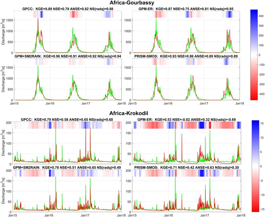
www.nature.com/scientificreports/
indirectly on ground observations (e.g., through assimilation for modelling or used as reference for satellite
products), and hence their reliability over scarcely gauged areas is highly uncertain9.
In the recent years, satellite rainfall products have been largely improved, mainly thanks to the successful
launch of the global precipitation measurement (GPM) core satellite in 201410. GPM provides quasi-global rain-
fall measurements by integrating a constellation of geostationary and polar-orbiting satellite sensors through a
“top down” approach, i.e., based on the inversion of the upwelling radiation or backscattered signal (for radars)
by atmospheric hydrometeors that is related to the surface precipitation rate. GPM is currently providing three
operational products based on the Integrated Multi-Satellite Retrievals for GPM (IMERG) algorithm, i.e., Early,
Late and Final Run. The three versions have spatial and temporal resolution of 0.1-° and 30-min and different
latency: 4 h, 12 h and 3.5 months for the Early, Late, and Final Run, r espectively11.
In parallel to these developments, in the last 5 years, new “bottom up” approaches based on the inversion
of the satellite soil moisture signal have been developed that provide accumulated rainfall estimates between
two satellite overpasses12,13 or the correction/enhancement of top down products based on soil moisture signal
(e.g.,14,15). The bottom up approach clearly distinguishes from the state-of-the-art top down method (i.e., GPM)
as the rainfall signal is obtained\enhanced from the knowledge of the soil moisture signal, i.e., from the bottom
up. This relatively new approach has been tested with different satellite sensors (e.g., Soil Moisture Ocean Salinity,
SMOS, mission15,16; Soil Moisture Active and Passive, SMAP, mission17; and Advanced SCATterometer, ASCAT,
sensor18), and recently also by integrating multiple satellite soil moisture products9,19.
Top down and bottom up approaches have their own advantages and limitations. Several studies have dem-
onstrated clearly that their integration is providing a higher quality rainfall p roduct9,14–16,20,21. For hydrological
applications such as river flow prediction, the bottom up approach has been found to perform well22,23, and the
integration with the top down approaches particularly useful1,24–26. For instance, Camici et al.1 have tested differ-
ent satellite precipitation products for river flow prediction over 15 catchments in the Mediterranean Basin and
have demonstrated that integrating top down and bottom up approaches improves the simulation of discharge
for all basins.
In data scarce regions, the assessment of the quality of satellite precipitation is limited from the availability
of ground observations and alternative approaches need to be implemented27. Recently, Massari et al.6 proposed
the Triple Collocation approach28 for the assessment of satellite rainfall products in ungauged areas by profiting
from three independent datasets. Massari et al.9 and Brocca et al.18 have recently performed Triple Collocation for
assessing newly derived satellite rainfall products obtaining that the products based on the bottom up approach18,
and on the integration of bottom up and top down approaches9, have very good performance in Africa and South
America. Based on these results, we believe it is important and urgent to carry out the hydrological validation
of such products in Africa, where there is a strong need for accurate rainfall data. Due to the scarcity of stream
gauges, the hydrological validation of satellite rainfall products in Africa has been carried out on a limited
number of studies as recently reviewed by Maggioni and M assari4. Previous studies (e.g.,1,2,29–32) evaluated the
performance of classical state-of-the-art satellite rainfall products such as CMORPH (Climate Prediction Center
Morphing technique33), TMPA (Tropical Rainfall Measuring Mission Multi-Satellite Precipitation A nalysis34), and
PERSIANN (Precipitation Estimation from Remotely Sensed Information using Artificial Neural N etworks35).
All these studies pointed out that after bias correction of satellite precipitation products, and in some studies also
after model recalibration, improved performances in terms of river flow simulation were obtained with respect to
the use of original products. However, to our knowledge, the hydrological validation of GPM IMERG products
in Africa has not been yet carried out.
On this basis, the main purpose of this study is to investigate the accuracy of top down and bottom up
satellite rainfall products for hydrological prediction in data scarce regions. Specifically, we have selected 10
basins in Europe (4), West Africa (3) and South Africa (3) for which daily stream gauge observations in the
period 2015–2017 are available, i.e., after the launch of GPM core satellite. The three regions are characterized
by good (Europe), medium (South Africa) and poor (West Africa) density of rain gauges. Our main focus is the
understanding of the capability of satellite rainfall products in data scarce regions, therefore we have targeted
African basins. Four satellite rainfall products have been assessed: (1) IMERG Early Run, (2) GPM+SM2RAIN (9,
available here: https://doi.org/10.5281/zenodo.3345322), (3) precipitation Inferred from Soil Moisture (PRISM)
applied to SMOS, i.e., PRISM-SMOS, and (4) PRISM-SMAP. The two last PRISM-based products have been
obtained from the integration of IMERG Early Run with SMOS and SMAP soil moisture through the procedure
described in15,36. Even though not useful for our target application, for completeness, the 5th European Centre
for Medium-Range Weather Forecasts (ECMWF) reanalysis (ERA537), the ground-based Global Precipitation
Climatology Centre product ( GPCC38) and the gauge-corrected IMERG Final Run product (GPM-FR)11 have
been considered. We underline, however, that the latter 3 products use directly (GPCC and GPM-FR) and indi-
rectly (ERA5) ground observations and hence they are available only with 1+ months latency. Therefore, their
use for operational river flow prediction or water resources management in the real-world is not feasible and
are used here just for comparison. Moreover, in developing countries, the accessibility to ground observations
is not always ensured. To obtain robust results, three different rainfall-runoff models have been used: MISDc
(Modello Idrologico Semi-Distribuito in continuo44), GR4J (modèle du Génie Rural à 4 paramètres Journalier45),
and HYMOD (HYdrologic MODel46).
The two main research questions addressed in this study are:
1. Do the latest satellite rainfall products outperform ground-based datasets? Are such products useful for river
flow prediction in scarcely gauged regions such as Africa?
2. Is there a benefit in the integration of top down and bottom up approaches for river flow prediction?
Scientific Reports | (2020) 10:12517 | https://doi.org/10.1038/s41598-020-69343-x 2
Vol:.(1234567890)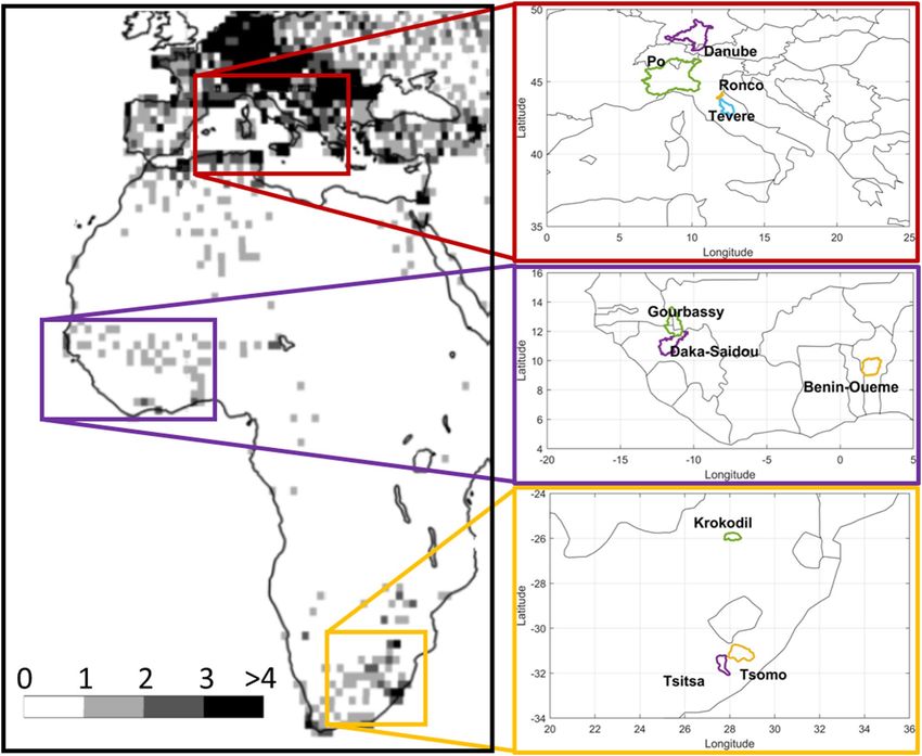
www.nature.com/scientificreports/
Figure 1. Kling–Gupta Efficiency in the different basins for all products and for the three rainfall-runoff
models. For each boxplot, the horizontal line represents the median values and the box represents the 25th and
75th percentile, the dotted whiskers extend to the extreme data points and cross symbols represent outliers. The
numbers in the boxes represent the mean values.
Results
The assessment of the satellite products for river flow prediction in the investigated basins has been performed
in different steps. Firstly, the three rainfall-runoff models have been applied to all basins to identify the more
suitable model for performing the analysis. Secondly, thanks to the high density of rain gauge stations in Europe,
a detailed analysis is carried out in which both rainfall and hydrological validation has been performed. Thirdly,
triple Collocation has been used to investigate the quality of the products in Africa in terms of rainfall. Finally,
the products performance in terms of river flow prediction in Africa has been assessed.
Selection of the more suitable rainfall‑runoff model. As described in methods, the three rainfall-
runoff models have been calibrated for the whole period of observations for each basin and rainfall product. The
three models have been run in the lumped-mode, i.e., by considering the input rainfall and temperature data
spatially aggregate at the basin scale. To investigate the variability of model performance in the different basins,
Fig. 1 shows as boxplots the results in terms of Kling–Gupta efficiency (KGE39) for all products, separated by
basin and by models. For each boxplot, the horizontal line represents the median values and the box represents
the 25th and 75th percentile, the dotted whiskers extend to the extreme data points and cross symbols represent
outliers. As it can be seen, mean performances for the different basins should be considered satisfactory for
MISDc and HYMOD models, i.e., KGE greater than 0.71 and 0.56. For many basins, mean KGE is greater than
0.80 indicating that at least for some models and products the performance in reproducing river discharge is
very good. Some models or input rainfall configurations provide unreliable results, particularly for Krokodil and
Benin-Oueme basins in Africa. For MISDc and HYMOD, the overall results in West Africa are even better than
in Europe thanks to the strong seasonality of river discharge observations for such basins that allows us to obtain
better performance in terms of KGE (due to the high temporal correlation, R > 0.9, that is one of the components
of KGE39). Among the three rainfall-runoff models, MISDc has been found to perform the best with mean
KGE = 0.83 while HYMOD (mean KGE = 0.76) and GR4J (mean KGE = 0.60) show a less good agreement with
river discharge observations. Therefore, MISDc model has been selected for the subsequent analyses.
Rainfall and hydrological assessment in Europe. The quality of rainfall products has been firstly
assessed in Europe through a comparison with the reference datasets, i.e., PITA (Italian Rainfall Dataset) for the
Italian basins and EOBS (ECA&D rainfall dataset) for Danube basin. Results are summarized in Fig. 2 in which
the box plots of R (Pearson’s Correlation Coefficient), KGE, absolute value of rBIAS (relative BIAS), |rBIAS|, and
rRMSE (relative root mean square error) are illustrated for all products, including EOBS. Long latency products
are shown in the grey area to differentiate them from the short latency products. The different scores provide a
similar assessment with the products with higher R and KGE also showing lower |rBIAS| and rRMSE. ERA5 is
the best long latency products with mean R = 0.87 and KGE = 0.84. ERA5 is also characterized by low |rBIAS| and
rRMSE. Among the short latency satellite-only products, GPM+SM2RAIN provides the best agreement with
the reference rainfall performing slightly better than GPM-FR and GPCC, on average. In this region, where the
density of rain gauge is relatively high and the amount of rainfall information shared by GPCC and the reference
rainfall is likely substantial, this result is unexpected. We attributed it to the coarse resolution of GPCC likely not
suitable to reproduce the actual rainfall pattern over complex topography regions as in the investigated basins
Scientific Reports | (2020) 10:12517 | https://doi.org/10.1038/s41598-020-69343-x 3
Vol.:(0123456789)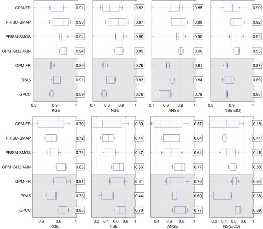
www.nature.com/scientificreports/
Figure 2. Correlation coefficient, R, Kling-Gupta Efficiency, KGE, absolute value of relative bias, |rBIAS|,
and relative root mean square error, rRMSE, for the different products in European basins with respect to
reference rainfall. Reference rainfall is PITA for Italian basins and EOBS for Danube basin (Danube basin is not
considered for EOBS product). For each boxplot, the horizontal line represents the median values and the box
represents the 25th and 75th percentile, the dotted whiskers extend to the extreme data points and cross symbols
represent outliers. The numbers in the boxes represent the mean values.
Figure 3. Kling-Gupta Efficiency, KGE, Nash-Sutcliff Efficiency, NSE, NSE for high flows, ANSE, and NSE
for low flows, NS(radQ), in the European basins for all products and MISDc model. For each boxplot, the
horizontal line represents the median values and the box represents the 25th and 75th percentile, the dotted
whiskers extend to the extreme data points and cross symbols represent outliers. The numbers in the boxes
represent the mean values. Note that x-axis starts at 0.3 to improve visualization.
in southern Europe. GPM-ER is performing less good than soil moisture corrected products, particularly in
terms of rRMSE, similar to the gauge-based EOBS product. The latter is known to have low accuracy in southern
Europe due to the low density of rain gauges used for its development in such area43. The results are in good
agreement with those reported i n9 who have shown R values of GPM+SM2RAIN ~ 15 to 20% higher than GPM-
ER in Europe.
Bearing in mind the results of the rainfall assessment, the products performance in terms of river flow pre-
diction in the European basins are analysed. To investigate the variability of MISDc performance for the differ-
ent products, in Fig. 3, KGE, NSE (Nash Sutcliffe Efficiency), ANSE (NSE for high flows) and NS(radQ) (NSE
for low flows) values for all basins separated by product are shown. In terms of KGE, good performances have
been obtained with rain gauge observations from GPCC, ERA5 and GPM-FR with a mean KGE equal to 0.89,
Scientific Reports | (2020) 10:12517 | https://doi.org/10.1038/s41598-020-69343-x 4
Vol:.(1234567890)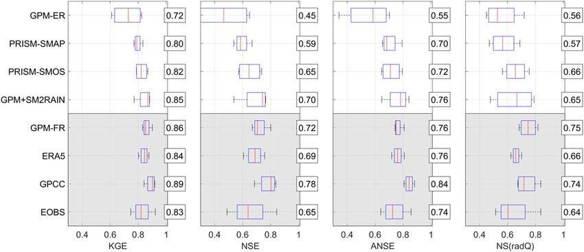
www.nature.com/scientificreports/
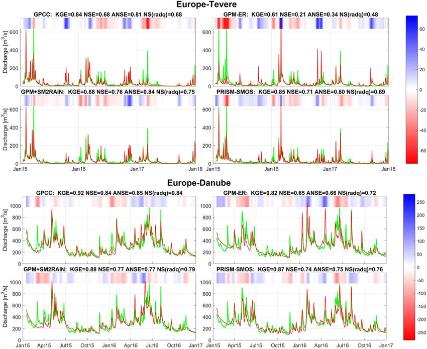
Figure 4. Observed (green tick lines) versus simulated (red lines) river discharge obtained through MISDc
rainfall-runoff model for Tevere (top panels) and Danube (lower panels) basin by using as rainfall input: GPCC
(top left of each panel), GPM-ER (top right), GPM+SM2RAIN (bottom left), and PRISM-SMOS (bottom right).
In the title the performance scores in terms of Kling-Gupta Efficiency, KGE, Nash-Sutcliff Efficiency, NSE, NSE
for high flows, ANSE, and NSE for low flows, NS(radQ), is given. In the top of each panel, the coloured bar has
3/s) between simulated and
darker blue (red) colours for larger positive (negative) errors, i.e., the difference (in m
observed discharge (see the colorbar on the right), and it helps visualizing the differences between observed and
simulated discharge.
0.84 and 0.86, respectively. Differently, EOBS dataset is performing less good (mean KGE = 0.83). Among the
four satellite-only rainfall products, GPM+SM2RAIN provides the best scores (mean KGE = 0.85) followed by
PRISM-SMOS (mean KGE = 0.82) and PRISM-SMAP (mean KGE = 0.80). GPM-ER provides lower performance
(mean KGE = 0.72). For the other performance scores, a similar picture is obtained with GPCC being the best
among the long latency products and GPM+SM2RAIN among the short latency products [except for NS(radQ)
in which PRISM-SMOS is better on average].
Two examples of simulation of river discharge for two basins in Europe (Tevere and Danube, Fig. 4) are shown.
For each figure, the simulation with MISDc rainfall-runoff model by using as rainfall input GPCC, GPM-ER,
GPM+SM2RAIN and PRISM-SMOS is illustrated. In the title of each subplot the performance scores are shown
in terms of KGE, NSE, ANSE, and NS(radQ). KGE is considered as the most important scores for river discharge
simulation and the rainfall-runoff models are calibrated by maximizing this score. The overall results highlight
the good performance of GPM+SM2RAIN and PRISM-SMOS (slightly better than PRISM-SMAP). Moreover,
the performances of GPM+SM2RAIN and PRISM-SMOS are always better than GPM-ER indicating that the
integration of soil moisture is highly beneficial, both for the reproduction of medium (as assessed by KGE) and
particularly of high (as assessed by ANSE) flows. A good example is visible for the Tevere basin (Fig. 4, top panels)
where the integrated products (GPM+SM2RAIN and PRISM-SMOS) corrects the overestimation of GPM-ER
at the beginning of 2016 and the underestimation at the beginning of 2015.
Scientific Reports | (2020) 10:12517 | https://doi.org/10.1038/s41598-020-69343-x 5
Vol.:(0123456789)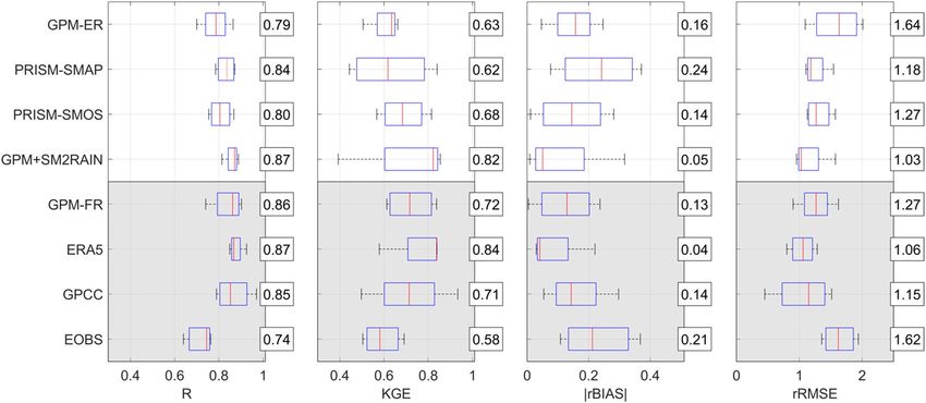
www.nature.com/scientificreports/
Europe West Africa South Africa
Tevere Po Ronco Danube Benin-Oueme Daka-Saidou Gourbassy Krokodil Tsitsa Tsomo Average
GPCC 0.898 0.917 0.930 0.911 0.732 0.576 0.725 0.920 0.919 0.911 0.844
ERA5 0.878 0.930 0.888 0.913 0.725 0.783 0.698 0.795 0.839 0.856 0.831
GPM+SM2RAIN 0.921 0.940 0.882 0.931 0.955 0.923 0.938 0.877 0.858 0.874 0.910
PRISM-SMOS 0.827 0.888 0.787 0.853 0.803 0.766 0.769 0.822 0.763 0.764 0.804
PRISM-SMAP 0.873 0.913 0.817 0.868 0.807 0.806 0.799 0.846 0.726 0.756 0.821
GPM-ER 0.793 0.902 0.718 0.824 0.762 0.748 0.789 0.748 0.689 0.707 0.768
Average 0.865 0.915 0.837 0.883 0.797 0.767 0.786 0.835 0.799 0.811
Table 1. Triple Collocation (TC) performance, in terms of TC correlation coefficient, TC-R, for the different
satellite rainfall products investigated in this study.
Triple collocation analysis. For each basin (including the European basins), the mean areal rainfall from
the seven rainfall products has been computed and used in the Triple Collocation analysis. Table 1 summarizes
the results for all the products, except GPM-FR, and for all the basins. In the table, it is highlighted in bold the
best product for each basin and in italic the second-best product. For West Africa basins, the best product is
GPM+SM2RAIN and PRISM-SMAP is the second best. This result clearly shows that for these basins, in which
the density of rain gauge is low, the satellite products could be a valid alternative to both gauge-based and reanal-
ysis rainfall products. In South Africa basins, GPCC is the best product and GPM+SM2RAIN is the second best.
In Europe, all the products perform better that in Africa basins with GPCC, ERA5 and GPM+SM2RAIN among
the best performing products. The latter results are in good agreement with the classical validation performed
in the previous section. Based on the overall results, on average GPM+SM2RAIN has the higher Triple Col-
location correlation (average TC-R = 0.91) followed by GPCC (0.84), ERA5 (0.83), and PRISM-SMAP (0.821).
By comparing the performance of the soil moisture corrected products (GPM+SM2RAIN, PRISM-SMOS, and
PRISM-SMAP) with GPM-ER, we have found that they always outperform GPM-ER suggesting a significant
benefit of the integration of satellite-based soil moisture. Specifically, the improvement is equal to 7% and 5% for
PRISM-SMAP and PRISM-SMOS, respectively, and it reaches 18% for GPM+SM2RAIN. Again, results are in
accordance with previous studies (see e.g., Fig. 9 in9) showing good performance of GPCC in South Africa and
low performance of both GPCC and ERA5 in West Africa. GPM+SM2RAIN is performing good throughout
Africa except over dense forests and desert areas in which the error of satellite soil moisture observations is high
and the use of such products is discouraged or masked out.
River flow and evapotranspiration prediction in Africa. Figure 5 shows KGE, NSE, ANSE and
NS(radQ) performance scores grouped for the West Africa (top panels) and South Africa (bottom panels). Some
interesting points can be summarized by analysing Fig. 5:
• Gauge-based\corrected and reanalysis products (GPCC, ERA5, GPM-FR) perform well in South Africa, as
expected, due to the presence of rain gauges, whereas in West Africa, they perform worse than soil moisture-
corrected products (GPM+SM2RAIN, PRISM-SMOS, and PRISM-SMAP) and equal to GPM-ER, on average;
• GPCC (ERA5) performs best among the long latency products in South Africa (West Africa);
• GPM-FR outperforms GPM-ER in South Africa, but not in West Africa due to the scarcity of rain gauges to
correct the product, therefore gauge correction in West Africa should be avoided due to the low density of
rain gauges;
• In West Africa, the soil moisture-corrected products (GPM+SM2RAIN, PRISM-SMOS, PRISM-SMAP)
perform very good with mean KGE and NSE higher than 0.93 and 0.87, respectively, and better than the long
latency products;
• Overall, GPM+SM2RAIN outperforms the PRISM-based products, particularly in South Africa where GPM-
ER is performing low (mean KGE = 0.58 and NSE = 0.39);
• GPM+SM2RAIN shows the better scores in terms of high flows (NSE and ANSE).
Figure 6 shows the observed and simulated river discharge for Gourbassy (top panels) and Krokodil (bottom
panels) basins by using GPCC, GPM-ER, GPM+SM2RAIN and PRISM-SMOS as input rainfall. In Gourbassy
basin all products are able to reproduce observed river discharge satisfactorily and GPM+SM2RAIN is perform-
ing the best, even better than GPCC (see a lso29). However, in Krokodil basin, also due to the higher temporal
variability of river discharge, the products performance is lower. Indeed, it is evident the problem of GPM-ER
in providing reliable simulations (NSE < 0); such problem is largely corrected from the integrated products
(NSE > 0.4) particularly during the flood period October 2016–March 2017.
An additional analysis has been carried out for African basins by comparing the simulated actual evapo-
transpiration data with Global Land Evaporation Amsterdam Model ( GLEAM49,50) dataset over the six African
basins. As the model is calibrated against river discharge observations, this assessment might be considered as
an independent validation that also ensures the consistent closure of the water balance. Indeed, we expect that
higher quality rainfall products provide a better agreement with evapotranspiration fluxes provided by GLEAM.
Results have been evaluated in terms of R to assess products capability to reproduce the temporal variability of
Scientific Reports | (2020) 10:12517 | https://doi.org/10.1038/s41598-020-69343-x 6
Vol:.(1234567890)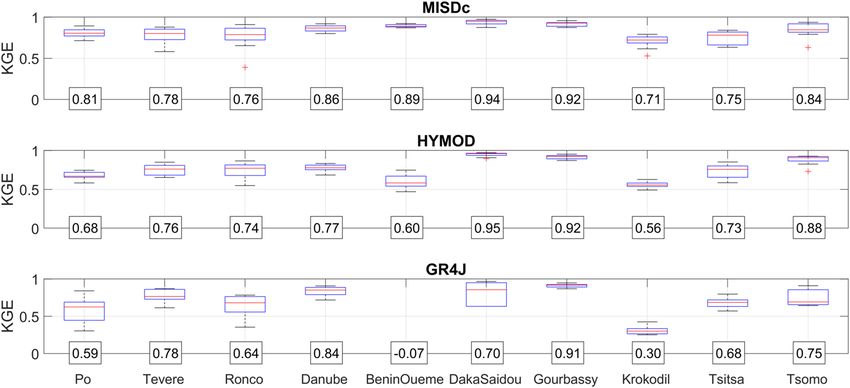
www.nature.com/scientificreports/

                            Figure 5.  As in Fig. 3 for West Africa (top panels) and South Africa (bottom panels). Note that x-axis starts at
                            different values to improve visualization.

                            actual evapotranspiration. For all basins, performances are relatively good with R values ranging between 0.7
                            and 0.85. For all African basins, GPM+SM2RAIN is slightly outperforming the others with mean R equal to 0.79,
                            followed by PRISM-SMOS, GPCC and ERA5 (0.78). In West Africa the best score is obtained from GPM-ER
                            (0.82) while in South Africa from GPM+SM2RAIN (0.81). The good performance of the integrated products
                            (GPM+SM2RAIN and PRISM-SMOS) might be attributed to the use of satellite soil moisture data that assure a
                            better closure of the water balance and thus provide better evapotranspiration estimates. However, such prelimi-
                            nary results have to be confirmed from the analysis over a larger number of basins (and longer time periods).
                                In order to investigate the reasons for the different performance of GPM+SM2RAIN and PRISM-based prod-
                            ucts, we have computed the daily correlation of these rainfall products with GPCC and GPM-ER. The correlation
                            of PRISM-based products and GPM-ER is higher than 0.93 thus highlighting that the soil moisture correction
                            with PRISM provides a rainfall product similar to GPM-ER. Differently, the correlation of GPM+SM2RAIN and
                            GPM-ER is lower and, on average, equal to 0.82. Therefore, in regions where GPM-ER is not performing well
                            (e.g., South Africa), the lower performance of PRISM-based products with respect to GPM+SM2RAIN might
                            be attributed to their stronger dependence with GPM-ER.

                            Discussion and conclusions
                            The hydrological validation of satellite rainfall products has several advantages and benefits with respect to the
                            validation with ground rainfall observations:

Scientific Reports |   (2020) 10:12517 |               https://doi.org/10.1038/s41598-020-69343-x                                               7

                                                                                                                                        Vol.:(0123456789)
www.nature.com/scientificreports/
Figure 6. As in Fig. 4 for Gourbassy basin in West Africa (top panels) and Krokodil basin in South Africa
(bottom panels).
1. The assessment is carried out with river discharge observations and hence it is fully independent from ground
rainfall observations that are used in gauge-corrected products. Therefore, the problem of validating products
including ground observations (e.g., GPM-FR) is overcome.
2. The assessment is carried out at basin scale. Therefore, for basins larger than 1,000 km2 the scale of the valida-
tion data is comparable with the resolution of the satellite products thus solving the point to area validation
problem encountered when rain gauge observations are used (e.g.,40).
3. The results provide direct information on the use of the satellite rainfall product for hydrological applica-
tions, e.g., river flow prediction and water resources management. Therefore, the real-world impact of the
products is assessed.
In the hydrological validation, the latency is fundamental. Indeed, products with latency larger than 3 days
have very little/no use in operational hydrological applications. In this study, we have performed the hydrologi-
cal validation also for long latency products (GPCC, ERA5, and GPM-FR), but their actual use for hydrological
applications is not feasible.
The results of the classical rainfall validation (Fig. 2), Triple Collocation (Table 1) and of the hydrological
validation of the satellite rainfall products (Figs. 3,5) are consistent. Specifically, it is evident that in the three
analyses, the soil moisture corrected products outperform the GPM-ER dataset, and, on average, the best per-
forming product is GPM+SM2RAIN. This consistency adds value to the overall analysis performed in this study
that can be considered robust and reliable. However, it should be underlined that in regions characterized by
frozen soils, snow and dense forests, satellite soil moisture products accuracy is expected to be low and hence
the correction will be not effective.
A potential reason for the better performance of the GPM+SM2RAIN product for high flows should be
attributed to the correction with satellite soil moisture data. Indeed, GPM-ER data are based on instantaneous
Scientific Reports | (2020) 10:12517 | https://doi.org/10.1038/s41598-020-69343-x 8
Vol:.(1234567890)www.nature.com/scientificreports/
snap shots a few times a day, that may miss critical storms between the satellite over passes. Rain gauge datasets
may miss small storms between the stations. Consequently, the simulated river flow based on GPM-ER or rain
gauge rainfall data only may be underestimated, especially when there are many or heavy missed storms that
cause high flows. Satellite soil moisture data may catch the footprints of the missed storms and thus may help
improve the river discharge forecasts if they are used to correct the rainfall data.
Four limitations of this study can be identified. Firstly, the use of a short time period (2–3 years) for perfor-
mance assessment might be too short to obtain reliable results. We have partly addressed this problem by using
three different rainfall-runoff models and without splitting the period in calibration and validation. However,
future studies will be performed with a longer time period thanks to the recent availability of GPM products
reprocessed starting in 2000. Secondly, the use of lumped rainfall-runoff models for performing hydrological
predictions over large basins might be questionable. The overall good performances that we have obtained (see
Fig. 1) allows us to conclude that the results are robust but the use of distributed rainfall-runoff modelling is
foreseen for future studies (e.g.,23). Thirdly, the number of basins in which the assessment has been carried out
is limited to ten as the collection of recent data of river discharge, particularly over African basins, is particu-
larly challenging. As above, the use of a larger number of basins is among the next step for this research activity.
Fourthly, the rainfall-runoff models have been calibrated in each basin and the obtained performance might
be partly influenced by the tuning of the parameters. The testing of the products without calibration will be the
object of future investigations once a larger number of basins and longer time series will be available.
It should be highlighted that, to our knowledge, this is the first study performing the hydrological validation
of GPM products in Africa. In addition, the validation of three long latency products has been carried out to
answer the research question: do the latest satellite rainfall products outperform ground-based datasets for river
flow prediction? The main outcome of this study is the significant benefit of integrating satellite soil moisture
data for improving the performance of satellite rainfall products for hydrological s imulations25,26. The improve-
ment of soil moisture-corrected rainfall products with respect to GPM-ER is around 20% in terms of KGE for
GPM+SM2RAIN (from 0.74 to 0.87, Fig. 2); and slightly lower for PRISM-based products (0.85 for PRISM-SMOS
and from 0.74 to 0.82 for PRISM-SMAP). Differently from previous studies (see e.g.,1,23,30,32, we have found that
GPM+SM2RAIN is outperforming the long latency products based on rain gauge and reanalysis. This result
should be attributed to: (1) the high-quality of the GPM+SM2RAIN rainfall product which is based on the latest
GPM satellite product and integrated with soil moisture derived rainfall from multiple satellites/sensors (SMOS,
SMAP and ASCAT), and (2) the low density of rain gauges particularly in West Africa basins. The assessment in
terms of reproduction of actual evapotranspiration has confirmed the slightly higher quality of GPM+SM2RAIN
with respect to gauge-based and reanalysis products over African basins.
It should be underlined that GPM+SM2RAIN and PRISM-based satellite rainfall products are potentially
available in with a latency < 3 days, thus representing an important new data source for river flow forecasting
worldwide. The good results of the hydrological validation of these newly derived short latency satellite rainfall
products highlight the strong need to disseminate such products for hydrological (and agricultural) applications
within developing countries (e.g., Africa and South America).
Methods
Study area and datasets. To perform a robust assessment of the satellite rainfall products for river flow
prediction, a dataset of six basins in Africa and four basins in Europe has been collected (see Fig. 7; Table 2).
The selection of the basins has been primarily driven by river discharge data availability in the recent period
2015–2017, which are quite rare, particularly for basins in Africa. River discharge data in West and South Africa
has been collected through direct contact with local river basins authorities from the authors, and hence a lim-
ited number of 6 basins has been made available at the time of writing. Basin area ranges from 548 km2 for Ronco
basin to 55,183 km2 for Po basin (at Boretto station) thus covering a wide range of basin sizes. For each basin,
daily river discharge observations for the period 2015–2017 are available; for some basins, data are available only
from 2015 to 2016. The density of rain gauges in each basin, as obtained from GPCC dataset, is also reported
in Table 2. Air temperature data have been collected from the National Centers for Environmental Prediction
(NCEP) reanalysis d ataset41 and they are used for computing mean areal evapotranspiration at the basin scale
through the adapted Blaney and Criddle Equation42.
Precipitation datasets. Daily precipitation observations have been collected from nine different datasets.
Two reference datasets have been collected in Europe. Firstly, the ECA&D rainfall dataset E-OBS (EOBS)
gridded dataset has been c onsidered43. The station dataset comprises a network of 2,316 stations, with the high-
est station density in Northern and Central Europe and lower density in the Mediterranean. We have used the
0.25° regular latitude–longitude grid with daily resolution. Secondly, in Italy, gridded rainfall data provided by
3,000+ stations of the National Department of Civil P rotection20 have been used (PITA). The data are gridded
at 0.1° resolution and aggregated at daily temporal scale.
Ground-based observations are collected from G PCC38 that is a global dataset at 1° resolution and daily
time step. The gauge density of GPCC is lower than EOBS and particularly PITA, therefore GPCC is used not
as reference but only as alternative gauge-based product. Reanalysis is taken from the latest ECMWF reanalysis
ERA537 with a temporal resolution of 1-h and spatial resolution of nearly 36 km. As gauge-corrected satellite
product, we have used the Integrated Multi-Satellite Retrievals for GPM (IMERG) Final Run version 5 11 for
which ground observations from GPCC are used to correct monthly accumulation successively rescaled at
hourly time scale. IMERG Final Run, hereinafter GPM-FR, is available from 2014 at 0.1° spatial resolution and
with a temporal resolution of 30-min. These three products, i.e., GPCC, ERA5 and GPM-FR are available with
a latency of 1+ months.
Scientific Reports | (2020) 10:12517 | https://doi.org/10.1038/s41598-020-69343-x 9
Vol.:(0123456789)www.nature.com/scientificreports/
Figure 7. Location of the study basins selected for the hydrological validation in Europe (top right), West
Africa (middle right), and South Africa (bottom right). On the left the number of stations used for the GPCC
First Guess 1.0° product for years 2015–2018 are shown. The map has been generated by using Matlab software.
Basin name Station Region Area (km2) #rain gauges/10,000 km2 (GPCC) Data period
Po Boretto Europe 55,183 >4 2015–2016
Tevere Monte Molino Europe 5,269 >4 2015–2017
Ronco Coccolia Europe 548 >4 2015–2016
Danube Ingolstadt Europe 20,001 >4 2015–2016
Benin-Oueme Beteorou West Africa 12,000 1–2 2015–2016
Daka-Saidou Sabere Bani West Africa 15,659 1 2015–2017
Gourbassy Diokéba West Africa 16,134 1 2015–2017
Krokodil Kalkheuwel South Africa 2,551 2–3 2015–2017
Tsitsa Xonkonxa South Africa 4,285 2–3 2015–2017
Tsomo Wyk Maduma South Africa 2,359 2–3 2015–2017
Table 2. List of the selected basins with the information on the location, the basin area, the density of rain
gauges (from GPCC) and the data period.
Four different satellite-only products have been used. The IMERG Early Run version 5, hereinafter GPM-ER11
is characterized by a spatial\temporal resolution of 0.1°\30-min. Three products that integrates the top down
GPM-ER with satellite soil moisture data have been tested. The SM2RAIN-based satellite rainfall product, i.e.,
GPM+SM2RAIN9, integrates GPM-ER with SM2RAIN-based product applied to SMAP, SMOS and ASCAT
satellite soil moisture. GPM+SM2RAIN (https://zenodo.org/record/3345323) has a spatial resolution of 0.25°
Scientific Reports | (2020) 10:12517 | https://doi.org/10.1038/s41598-020-69343-x 10
Vol:.(1234567890)www.nature.com/scientificreports/
Product Data period Spatial resolution (°) Temporal resolution Latency References
Reference products
46
EOBS 1950-on going 0.25 1-day 3 months
34
PITA 1978-on going ~ 0.1 1-day 15 days
Long latency products (> 1 month)
35
GPCC 1950-on going 1 1-day 15–45 days
34
ERA5 1978-on going 0.36 1-h 3 months
9
GPM-final run 2014-on going 0.1 30-min > 1 month
Short latency products (< 3 days)
9
GPM-early run 2015-on going 0.1 30-min 12 h
7
GPM+SM2RAIN 2015-on going 0.25 1-day 3 days
13,33
PRISM-SMOS 2015-on going 0.25 3-h 3 days
13,33
PRISM-SMAP 2015-on going 0.25 3-h 3 days
Table 3. List of the selected rainfall products for this study.
and daily temporal resolution. Two PRISM-based satellite rainfall products have been considered15,36. The PRISM
method is applied to correct GPM-ER with SMOS (PRISM-SMOS) and SMAP (PRISM-SMAP) soil moisture
observations. PRISM-SMOS and PRISM-SMAP have a spatial resolution of 0.25° and 3-h temporal resolution.
Details on the characteristic of GPM+SM2RAIN algorithm and on PRISM approach is given in11,36 and we refer
the interested reader to these publications for more specific information. Here, briefly, we underline the main
difference between the two approaches that relies on the method used for integrating soil moisture observations.
In GPM+SM2RAIN, a soil moisture-based rainfall product obtained from the application of SM2RAIN to satellite
soil moisture products (SMAP, SMOS and ASCAT) is merged with GPM-ER via the Optimal Linear Combina-
tion approach51. In PRISM, satellite soil moisture data (SMOS and SMAP) are assimilated into a simplified soil
moisture model using GPM-ER as input. The innovations after the assimilation are exploited for correcting the
input precipitation data thus obtaining the PRISM-based products.
A summary of the precipitation products used in this study is given in Table 3. For each basin, the precipita-
tion data have been aggregated at basin scale spatially averaging the observations of all cells contained in the
basin and resampled at daily temporal resolution for the products available at sub-daily time scale (i.e., GPM-ER,
GPM-FR, and ERA5).
For each basin, and for each rainfall-runoff model (see “Discussion and conclusions”), seven river discharge
simulations have been carried out, i.e., by using as precipitation input three long latency (> 1 month) products: (1)
GPCC, (2) ERA5, and (3) GPM-FR; and 4 short latency (< 3 days) products: (1) GPM-ER, (2) GPM+SM2RAIN,
(3) PRISM-SMOS, and (4) PRISM-SMAP.
Actual evaporation dataset. In African basins, the assessment of products performance has been carried
out also considering the capability of the rainfall-runoff model to reproduce the temporal variability of actual
evapotranspiration, another important component of the water balance. As reference, we have considered the
dataset obtained from the Global Land Evaporation Amsterdam Model ( GLEAM49,50). Specifically, the actual
evapotranspiration dataset from GLEAM v3.3b has been considered, i.e., not including ERA5 data as input,
which has a spatial resolution of 0.25°, daily temporal resolution and covers the period 2003–2018. As for the
precipitation dataset, actual evapotranspiration data have been aggregated at basin scale spatially averaging the
observations of all cells contained in the basin.
Rainfall‑runoff models
MISDc. MISDc—“Modello Idrologico Semi-Distribuito in continuo”—is a continuous rainfall-runoff model
developed by Brocca et al.44 for the operational forecasting of flood events in central Italy. In this study, a two-
layer version of the model has been used. With respect to the previous version, it includes a snow module and a
different infiltration equation. The model uses as input daily rainfall and potential evapotranspiration data and
simulates the temporal evolution of river discharge, actual evapotranspiration and soil moisture for a surface and
a root-zone soil layer. Water is extracted from the first layer by evapotranspiration, which is calculated by a linear
function between the potential evaporation and soil moisture. A non-linear relation is used for computing the
percolation from the surface to the root-zone layer. The rainfall excess is calculated by a power law relationship
as a function of the first layer soil moisture while base flow is a non-linear function of the soil moisture of the
second layer. The MISDc version used for this study has nine parameters to be estimated by calibration against
ground-based river discharge observations. Full details on model equations are given in44 and recent applica-
tions with satellite observations can be found in1,26.
GR4J. GR4J is a lumped bucket-type model that represents the rainfall-runoff relationship using an intercep-
tion function, two stores, a unit hydrograph and an exchange f unction45. GR4J operates at a catchment scale with
a daily time-step. The development of the GR4J model was initiated by Claude Michel at the beginning of the
1980s at Cemagref. The first version of the model only had a single parameter. Further development of the GR4J
model was undertaken using a modelling approach where large numbers of catchments were used to evaluate
Scientific Reports | (2020) 10:12517 | https://doi.org/10.1038/s41598-020-69343-x 11
Vol.:(0123456789)www.nature.com/scientificreports/
and improve the model. The GR4J version used for this study has five parameters to be estimated by calibration
against ground-based river discharge observations and uses as input daily rainfall and potential evapotranspira-
tion data.
HYMOD. HYMOD is a step rainfall excess model based on a nonlinear water storage capacity distribution
f unction46. The routing system includes a sequence of three quick-flow tanks which describe surface flow, in par-
allel to a slow-flow tank for groundwater. The HYMOD model is a flexible solution that is increasingly adopted
for its capability of providing a good fit in several practical applications. It assumes that each point location in
the basin is characterised by a local value of soil water storage, which varies from zero in the impervious areas
up to a maximum value in the most permeable location of the catchment. Soil water storage is assumed to be
randomly varying, so that for an assigned value of soil water storage a probability distribution is introduced. The
HYMOD version used for this study has five parameters to be estimated by calibration against ground-based
river discharge observations and uses as input daily rainfall and potential evapotranspiration data.
Processing steps for performing the hydrological validation. The use of satellite-based rain-
fall products for river flow modelling requires some pre-processing steps. We have employed here the same
approach as in Camici et al.1 in which the rainfall-runoff model has been recalibrated for each of the different
rainfall product by maximizing the Kling–Gupta efficiency ( KGE39) with respect to observed daily discharge.
KGE is a performance index with optimal value equal to 1; good, satisfactory and poor performance is obtained
for KGE between 0.7 and 1, 0.4 and 0.7, lower than 0.4, respectively. In addition to KGE, the Nash–Sutcliffe
efficiency, NSE47, the NSE for high flows, A NSE1, and the NSE for low flows, NS(radQ), i.e., computed on the
squared root of river discharge, performance scores have been employed. For all these scores the optimal value
is equal to 1 and negative values mean poor performances. NSE, ANSE are to be used for assessing model per-
formances for high and extremely high flows, respectively, while NS(radQ) for low flow conditions. Therefore,
for each rainfall product and basin, the parameter values of the three rainfall-runoff models have been calibrated
in a physically reasonable range of values to maximize KGE. A validation period has not been considered in
this analysis due to the limited length of the data period. Certainly, this is a limitation of the study as it does not
allow for the evaluation of the satellite rainfall product in an operational context. However, here we have aimed
to assess the best information that can be extracted from each rainfall product by using the maximum length of
the available data (limited to 3 years). Moreover, as all the products have been treated with the same procedure,
the fair comparison between them is ensured.
Rainfall assessment in Europe. In Europe, the assessment of rainfall products has been carried by con-
sidering classical statistical scores, i.e., the correlation coefficient, R, KGE, the relative bias, rBIAS, i.e., the bias
normalized with the temporal mean of the observations, and the relative root mean square error, rRMSE, i.e.,
the RMSE normalized with the temporal mean of the observations. As reference, we have used the PITA dataset
(based on 3,000+ rain gauges) for Italian basins and EOBS for Danube basin (the quality of EOBS is found not
very good in Italy).
Triple collocation analysis. To assess the quality of rainfall products in Africa, we have performed the
Triple Collocation analysis as in Massari et al.6. Indeed, for the African basins, we do not have a rainfall product
to be considered as reference, and Triple Collocation allows us to obtain an estimation of the error variances
of each product without the need of a reference. An additive error model has been assumed, and the extended
Triple Collocation approach48 has been applied thus providing the correlation against the hypothetical truth of
three independent rainfall products9,18, hereinafter TC-R. The additive error model has been selected as it has
been found better than the multiplicative model6 if daily rainfall observations are analysed. Daily rainfall obser-
vations are characterised by a large number of zeroes, particularly over dry areas, that deteriorate the accuracy
of Triple Collocation if a multiplicative error model is assumed. For details on the implementation of Triple Col-
location, the reader is referred to Massari et al.6,9. In the selection of the triplets, the independence of the errors
of the rainfall products has to be ensured. For instance, the two GPM products cannot be included in the same
triplet, and similarly GPCC and GPM-FR that uses GPCC observations for correcting monthly accumulations.
Therefore, for the assessment of the products the triplets have been formed by using GPCC, ERA5 and the four
satellite-only products (GPM-ER, GPM+SM2RAIN, PRISM-SMOS, and PRISM-SMAP). GPM-FR, including
both GPCC and GPM-ER, has not been assessed in this analysis as the independence with the other products
cannot be ensured.
Received: 24 October 2019; Accepted: 8 July 2020
References
1. Beck, H. E. et al. Global-scale evaluation of 22 precipitation datasets using gauge observations and hydrological modeling. Hydrol.
Earth Syst. Sci. 21(12), 6201–6217 (2017).
2. Dinku, T. et al. Validation of satellite rainfall products over East Africa’s complex topography. Int. J. Remote Sens. 28(7), 1503–1526
(2007).
3. Camici, S., Ciabatta, L., Massari, C. & Brocca, L. How reliable are satellite precipitation estimates for driving hydrological models:
A verification study over the Mediterranean area. J. Hydrol. 563, 950–961 (2018).
4. Maggioni, V. & Massari, C. On the performance of satellite precipitation products in riverine flood modeling: A review. J. Hydrol.
558, 214–224 (2018).
Scientific Reports | (2020) 10:12517 | https://doi.org/10.1038/s41598-020-69343-x 12
Vol:.(1234567890)www.nature.com/scientificreports/
5. Herold, N., Alexander, L. V., Donat, M. G., Contractor, S. & Becker, A. How much does it rain over land?. Geophys. Res. Lett. 43(1),
341–348 (2016).
6. Massari, C., Crow, W. & Brocca, L. An assessment of the accuracy of global rainfall estimates without ground-based observations.
Hydrol. Earth Syst. Sci. 21, 4347–4361 (2017).
7. Ebert, E. E., Janowiak, J. E. & Kidd, C. Comparison of near-real-time precipitation estimates from satellite observations and
numerical models. Bull. Am. Meteorol. Soc. 88(1), 47–64 (2017).
8. Kidd, C. et al. So, how much of the Earth’s surface is covered by rain gauges?. Bull. Am. Meteorol. Soc. 98(1), 69–78 (2017).
9. Massari, C. et al. A daily/25km short-latency rainfall product for data scarce regions based on the integration of the GPM IMERG
Early Run with multiple satellite soil moisture products. Hydrol. Earth Syst. Sci. 24, 2687–2710 (2020).
10. Hou, A. Y. et al. The global precipitation measurement (GPM) mission. Bull. Am. Meteorol. Soc. 95(5), 701–722 (2014).
11. Huffman, G., Bolvin, D., Braithwaite, D., Hsu, K., Joyce, R., Kidd, C., Nelkin, E., & Xie, P. (2018). Algorithm Theoretical Basis Docu-
ment (ATBD) Version 4.5. NASA Global Precipitation Measurement (GPM) Integrated Multi-satellitE Retrievals for GPM (IMERG)
NASA.
12. Brocca, L., Melone, F., Moramarco, T. & Wagner, W. A new method for rainfall estimation through soil moisture observations.
Geophys. Res. Lett. 40(5), 853–858 (2013).
13. Brocca, L. et al. Soil as a natural rain gauge: Estimating global rainfall from satellite soil moisture data. J. Geophys. Res. 119(9),
5128–5141 (2014).
14. Crow, W. T., Huffman, G. J., Bindlish, R. & Jackson, T. J. Improving satellite-based rainfall accumulation estimates using spaceborne
surface soil moisture retrievals. J. Hydrometeoro. 10, 199–212 (2009).
15. Román-Cascón, C. et al. Correcting satellite-based precipitation products through SMOS soil moisture data assimilation in two
land-surface models of different complexity: API and SURFEX. Remote Sens. Environ. 200, 295–310 (2017).
16. Brocca, L. et al. Rainfall estimation by inverting SMOS soil moisture estimates: A comparison of different methods over Australia.
J. Geophys. Res. 121(20), 12062–12079 (2016).
17. Koster, R. D., Brocca, L., Crow, W. T., Burgin, M. S. & De Lannoy, G. J. M. Precipitation estimation using L-band and C-band soil
moisture retrievals. Water Resour. Res. 52(9), 7213–7225 (2016).
18. Brocca, L. et al. SM2RAIN-ASCAT (2007–2018): Global daily satellite rainfall from ASCAT soil moisture. Earth Syst. Sci. Data
11, 1583–1601 (2019).
19. Tarpanelli, A. et al. Exploiting a constellation of satellite soil moisture sensors for accurate rainfall estimation. Adv. Water Resour.
108, 249–255 (2017).
20. Ciabatta, L. et al. Integration of satellite soil moisture and rainfall observations over the Italian territory. J. Hydrometeorol. 16(3),
1341–1355 (2015).
21. Ciabatta, L. et al. Daily precipitation estimation through different microwave sensors: Verification study over Italy. J. Hydrol. 545,
436–450 (2017).
22. Fereidoon, M., Koch, M. & Brocca, L. Predicting rainfall and runoff through satellite soil moisture data and SWAT modelling for
a poorly gauged basin in Iran. Water 11(3), 594 (2019).
23. Mazzoleni, M., Brandimarte, L. & Amaranto, A. Evaluating precipitation datasets for large-scale distributed hydrological model-
ling. J. Hydrol. 578, 124076 (2019).
24. Alvarez-Garreton, C. et al. Dual assimilation of satellite soil moisture to improve streamflow prediction in data-scarce catchments.
Water Resour. Res. 52, 5357–5375 (2016).
25. Ciabatta, L. et al. Rainfall-runoff modelling by using SM2RAIN-derived and state-of-the-art satellite rainfall products over Italy.
Int. J. Appl. Earth Obs. Geoinf. 48, 163–173 (2016).
26. Massari, C., Camici, S., Ciabatta, L. & Brocca, L. Exploiting satellite-based surface soil moisture for flood forecasting in the Medi-
terranean area: State update versus rainfall correction. Remote Sens. 10(2), 292 (2018).
27. Serrat-Capdevila, A., Valdes, J. B. & Stakhiv, E. Z. Water management applications for satellite precipitation products: Synthesis
and recommendations. J. Am. Water Resour. Assoc. 50, 509–525 (2014).
28. Stoffelen, A. Toward the true near-surface wind speed: Error modeling and calibration using triple collocation. J. Geophys. Res.
103, 7755 (1998).
29. Stisen, S. & Sandholt, I. Evaluation of remote-sensing-based rainfall products through predictive capability in hydrological runoff
modelling. Hydrol. Process. 24(7), 879–891 (2010).
30. Bitew, M. M. & Gebremichael, M. Assessment of satellite rainfall products for streamflow simulation in medium watersheds of
the Ethiopian highlands. Hydrol. Earth Syst. Sci. 15(4), 1147–1155 (2011).
31. Thiemig, V., Rojas, R., Zambrano-Bigiarini, M., Levizzani, V. & De Roo, A. Validation of satellite-based precipitation products
over sparsely gauged African river basins. J. Hydrometeorol. 13(6), 1760–1783 (2012).
32. Casse, C. et al. Potential of satellite rainfall products to predict Niger River flood events in Niamey. Atmos. Res. 163, 162–176
(2015).
33. Joyce, R. J., Janowiak, J. E., Arkin, P. A. & Xie, P. CMORPH: A method that produces global precipitation estimates from passive
microwave and infrared data at high spatial and temporal resolution. J. Hydrometeorol. 5, 487–503 (2004).
34. Huffman, G. J. et al. The TRMM multisatellite precipitation analysis (TMPA): Quasi global, multiyear, combined-sensor precipita-
tion estimates at fine scales. J. Hydrometeorol. 8(1), 38–55 (2007).
35. Sorooshian, S. et al. Evaluation of the PERSIANN system satellite-based estimates of tropical rainfall. Bull. Am. Meteorol. Soc. 81,
2035–2046 (2000).
36. Pellarin, T. et al. The Precipitation Inferred from Soil Moisture (PrISM) near real-time rainfall product: Evaluation and comparison.
Remote Sens. 12(3), 481 (2020).
37. Hersbach, H. et al. The ERA5 global reanalysis. Q. J. Roy. Meteor. Soc. (2020). https://doi.org/10.1002/qj.3803.
38. Schamm, K. et al. Global gridded precipitation over land: A description of the new GPCC First Guess Daily product. Earth Syst.
Sci. Data 6, 49–60 (2014).
39. Gupta, H. V., Kling, H., Yilmaz, K. K. & Martinez, G. F. Decomposition of the mean squared error and NSE performance criteria:
Implications for improving hydrological modelling. J. Hydrol. 377(1), 80–91 (2009).
40. Loew, A. et al. Validation practices for satellite based earth observation data across communities. Rev. Geophys. 55(3), 779–817
(2017).
41. Kalnay, E. et al. The NCEP/NCAR 40-year reanalysis project. Bull. Am. Meteorol. Soc. 77(3), 437–472 (1996).
42. Doorenbos, J, & Pruitt, W. O. Background and development of methods to predict reference crop evapotranspiration (ETo). In
Crop Water Requirements. FAO Irrigation and Drainage Paper No. 24 (Appendix II) pp. 108–119 (FAO, Rome, 1977)
43. Haylock, M. et al. A European daily high-resolution gridded data set of surface temperature and precipitation for 1950–2006. J.
Geophys. Res. Atmos. 113, D20119 (2008).
44. Brocca, L., Melone, F. & Moramarco, T. Distributed rainfall-runoff modelling for flood frequency estimation and flood forecasting.
Hydrol. Process. 25(18), 2801–2813 (2011).
45. Perrin, C., Michel, C. & Andréassian, V. Improvement of a parsimonious model for streamflow simulation. J. Hydrol. 279(1/4),
275–289 (2003).
46. Wagener, T. et al. A framework for development and application of hydrological models. Hydrol. Earth Syst. Sci. 5(1), 13–26 (2001).
Scientific Reports | (2020) 10:12517 | https://doi.org/10.1038/s41598-020-69343-x 13
Vol.:(0123456789)You can also read