A Distributed Architecture for Human-Drone Teaming: Timing Challenges and Interaction Opportunities - MDPI
←
→
Page content transcription
If your browser does not render page correctly, please read the page content below

sensors
Article
A Distributed Architecture for Human-Drone
Teaming: Timing Challenges and
Interaction Opportunities
Karin Anna Hummel *             , Manuela Pollak and Johannes Krahofer
 Department of Telecooperation, Johannes Kepler University, Altenberger Strasse 69, 4040 Linz, Austria;
 manuela.pollak@jku.at (M.P.); Johannes.Krahofer@gmx.at (J.K.)
 * Correspondence: karin_anna.hummel@jku.at; Tel.: +43-732-2468-4699

 Received: 15 October 2018; Accepted: 28 February 2019; Published: 20 March 2019

 Abstract: Drones are expected to operate autonomously, yet they will also interact with humans
 to solve tasks together. To support civilian human-drone teams, we propose a distributed
 architecture where sophisticated operations such as image recognition, coordination with humans,
 and flight-control decisions are made, not on-board the drone, but remotely. The benefits of such an
 architecture are the increased computational power available for image recognition and the possibility
 to integrate interfaces for humans. On the downside, communication is necessary, resulting in the
 delayed reception of commands. In this article, we discuss the design considerations of the distributed
 approach, a sample implementation on a smartphone, and an application to the concrete use case
 of bookshelf inventory. Further, we report experimentally-derived first insights into messaging and
 command response delays with a custom drone connected through Wi-Fi.

 Keywords: drones; UAVs (unmanned aerial vehicles); networked systems; network performance;
 human–robot interaction

1. Introduction
      In recent years, employing mini-drones, also known as UAVs (unmanned aerial vehicles) and
micro-aerial vehicles, in civilian applications has become popular. The capabilities of drones to screen
an area quickly with on-board cameras and to establish wireless networks in the air [1,2] provide
novel opportunities in search and rescue missions [3], 3D cartography, entertainment, (small) product
delivery, smart farming, surveillance, and many other application domains. Yet, assuring the technical
preconditions of safe and practical autonomous flight is challenging due to limited system reliability,
short flight-time, and restricting legal regulations. Further, in realistic settings, autonomous drones
will likely cooperate with humans, which is a new field of human–computer interaction.
      Employing drones in human-drone teams involves the coordination of autonomous drone
behavior and user interactions. A major challenge is to find a fitting architecture that supports both
aspects. One unconventional option to follow is a distributed system design, where only basic control
is implemented on the drone’s microcontroller and computationally-intense tasks of drone behavior
are executed on a more powerful remote computer, or even in a cloud computing infrastructure.
The on-board controller is basically used to receive commands and to execute them similar to manual
remote control. Such a distributed architecture is advantageous as it overcomes limitations in applying,
e.g., machine learning, image processing, and big data analysis on drones. Further, human interactions
can be integrated well into the remote control loop. On the downside, communication delays occur in
this distributed architecture.
      To split drone applications between the physical drone and a remote computer, the drone has
a model-based digital representation on the remote machine. The remote drone model is used to

Sensors 2019, 19, 1379; doi:10.3390/s19061379                                   www.mdpi.com/journal/sensors
Sensors 2019, 19, 1379                                                                           2 of 13

process the control logic based on sensory input such as camera images received from the physical
drone. The outcomes of the control logic are commands sent back to the drone, which adjusts its
behavior accordingly. Since control is a real-time task, there is a need for characterizing delays
and their effect on task decisions, in particular when communicating through standard wireless
communication networks.
      Our main focus is on investigating whether a distributed architecture and distributed control
loop to decide on the next actions are feasible and which delays have to be considered. Hereby, our
assumptions are that the drone provides camera images as a primary sensor input and that a human
is integrated in the system to form a team with the drone. To give first insights into the problem, we
present the implementation of a distributed architecture for human-drone teaming applied to a sample
task, as well as quantitative and qualitative experimental results. In detail, we make the following
contributions in the remainder of the paper:

•     In Section 2, we present a survey of the state-of-the-art in control and timing-related drone
      research and on human-drone teaming with a focus on human–drone interaction.
•     In general, drone systems are rather novel robotic systems and require a wide exploration of
      potential application fields. This is even more the case for human-drone teaming. We contribute
      by designing and implementing the functions necessary to provide a drone system for bookshelf
      inventory, which may be used by the research community as a sample test application. In Section 3,
      we describe this use case.
•     We introduce a distributed architecture for human-drone teams and model timing in this
      architecture. Further, we demonstrate the feasibility of such a distributed architecture with
      a prototype app implementation running on a smartphone, as detailed in Section 4.
•     We investigate the delay and aspects of the timing behavior in a real testbed with a Parrot Mambo
      drone equipped with an FPV (first person view) camera, operating through Wi-Fi in Section 5.
      Further, we provide qualitative insights for the specific use case of bookshelf inventory.

2. Related Work
     Preparing drones for complex, autonomous tasks that involve humans has been investigated from
various perspectives in the literature. Besides providing tools for deployment and remote testing, such
as the deployment tool provided for drone swarms in [4] and learning-based testing of spatio-temporal
properties in [5], understanding the real-time behavior of a drone system is crucial for operation.
Hereby, the control loop and the timing characteristics of autopilots are most demanding. Another
challenge is to define appropriate interfaces for human–drone interaction.

2.1. Control and Timing
      Controlling the flight behavior of modern micro-drones is supported by autonomously-operating
pilots such as the Ardupilot, a widely-used autopilot (http://ardupilot.org/). Typically, the navigation
path is determined remotely, e.g., by setting GPS waypoints in outdoor scenarios, but specific motion
control is performed locally on the drone using a low-level control loop that determines pitch, roll,
and yaw movement. The control loop is usually time-driven, i.e., periodically invoked with a constant
rate. An event-based, reactive approach is suggested in [6,7]. By adapting the control rate dynamically
based on environmental needs such as wind gusts and pressure gradients, a more efficient scheme
can be derived that saves energy, leading to an extension of the flight-time. Besides, more accurate
drone motion is achieved. In particular for indoor drones, vision is used for navigation, obstacle
identification, and obstacle avoidance. In [8], it is shown that vision-based navigation works well even
for very small drones termed pocket-drones that weigh only 40 g. In contrast to these local control
approaches, our architecture allows distributing parts of the control loop between the drone and a
remote computer.
Sensors 2019, 19, 1379                                                                             3 of 13

      Modeling the control loop allows understanding the drone’s behavior, to proof characteristics,
and to perform exhaustive tests. A particular aspect to model is the timing behavior. As in any other
cyber-physical system, the time between sensing, processing, and actuation has to remain below a
constraining bound. Concerning drones, information at least from inertial sensors and distance sensors
has to be continuously evaluated to control the flight behavior of the aircraft by activating motors
and rotors. To analyze the end-to-end time in the control loop, a pipe model is suggested in [9]. The
model allows for analyzing the reaction time, as well as the freshness of events, thus assuring bounded
operation at an early stage of development. The approach is validated by a port of the Cleanflight
flight controller firmware to Quest (Intel Aero board). In [10], the Ardupilot is modeled with the aim to
investigate timing behavior. With the model, it can be shown that the autopilot does not always meet
the timing requirements, which is a severe problem for fail-safe operation. These erroneous executions
are then also shown in real tests. Our work confirms the importance of accurate and bounded timing,
as well as unexpected delays in the autopilot of the Mambo drone.
      An approach similar to ours is taken by the work presented in [11]. A representative of a drone
(or a swarm of drones) is leveraged to control the actual drone in the field and to get feedback from
this field drone. This drone is termed the shadow drone. Besides real-time operation, the shadow
drone can also be used during implementation and testing. Latency and disruption are mentioned
as major challenges in [11]. In the paper, prototype implementations for the Parrot Rolling Spider
and AR Drone 2.0 are described, yet an evaluation is missing. In our work, we consider a model as
a representation of the physical drone used at the remote site, instead of operating a shadow drone.
Furthermore, we present the results of an experimental study of communication delays that occur
between the physical drone and the control unit running on an external computer.
      To leverage the processing power of high-performance computers, drone and cloud integration is
the natural next step. Related work has shown that integrating with a cloud can indeed provide benefits
to autonomous vehicles. In [12], remote resources such as terrestrial antennas and cloud infrastructures
are added to a local unmanned vehicle team (here, underwater vehicles). Computationally-extensive
tasks are executed in the cloud. Simulations demonstrate that including cloud resources allows for
performance improvements. Yet, this architecture considers a loosely-coupled distributed system
where real-time behavior is not an issue. Differently, the cloud is used to support vision-based
navigation in [13]. This real-time task makes use of cloud-based recognition of objects in order to avoid
collisions. The latencies of image frame delivery are in the range of 10 s of ms to about 1 s. These
latencies are confirmed by our study, which further evaluates the command response time.

2.2. Human–Drone Interaction
      In addition to the autopilot control loop, our work targets the integration of humans and drones
through suitable interfaces. This includes questions about how drones perceive humans and human
interactions, as well as how humans perceive drones. Drones may use cameras to interact with humans,
e.g., to avoid collisions with humans by applying obstacle avoidance methods and to react to human
gestures. Alternatively, drones may use messaging to receive user input through an arbitrary device
such as a remote control device, smartphone, smart watch, etc. In turn, drones may signal their
status to the human. In [14], drone gestures are used to signal acknowledgment. The basic gestures
are waggle, nod, and changing orientation. The drones used for experimentation are the Air-Robot
AR-100B, Parrot AR 2, and Parrot Bebop 2. Based on user studies, the work found that distances of
about 2 m are best to perform drone gestures and that orientation towards the human attracts human
attention very well. A simple way of interaction is to just attract the user to follow a drone, which even
works for visually-impaired humans following the sound emitted by a guiding drone [15]. Our aim in
this work extends the basic interaction options by adding the collaboration aspect of human-drone
teams. This means the drone and the human should work together to fulfill a given task. The human
has to be aware of the solving degree of the task and requires a means to help the drone to proceed.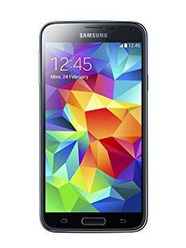
Sensors 2019, 19, 1379                                                                                4 of 13

3. Sample Task: Inventory of a Bookshelf
     To exemplify a joint human-drone team effort, we select the task of bookshelf inventory.
The drone’s task is to team-up with a human in order to survey the available books in an institution,
such as a public library. Integrating drones in such a task may allow speeding up inventories and
involving humans preferably only in non-standard, difficult, and unclear situations. Furthermore, as
drones can move in three dimensions, they are well suited to perform inventories even at high altitudes.
     In detail, bookshelf inventory requires (i) counting the number of books available and (ii) detecting
the book title, and potentially other information about the book. One option to simplify the task is
to label the books with barcodes, QR-codes, or RFID (radio frequency identification) tags. Another
option is to use image recognition to identify books and text recognition to derive the title, author, etc.
The latter is advantageous as it does not require any particular tags on the books. Thus, we choose
vision as the main input channel for performing the task and assume that the drone is equipped with
an on-board camera. A sample library bookshelf of our university and our experimentation drone
Parrot Mambo (https://www.parrot.com/eu/drones/parrot-mambo-fpv/) are depicted in Figure 1.

                               (a)                                             (b)
      Figure 1. Bookshelf inventory components: (a) university library bookshelves and (b) Parrot Mambo
      equipped with a FPV (first person view) camera.

      The drone operates indoors and mostly autonomously, i.e., it has to position itself close to the
bookshelf at a starting position to perform the scanning task thereafter. As a starting point, the upper
left corner of the shelf is searched for by finding the most left book in the top layer. Scanning is
implemented as a traditional search behavior, i.e., one layer of the whole shelf is scanned after the
other from the starting position following a zigzag movement pattern. The flight direction is alternated
between flying from left to right and right to left. A major challenge is to move accurately along
the optimal trajectory. The trajectory is calculated to allow the best placement for book recognition.
Whenever a new image is provided by the drone’s camera, image recognition is invoked.

3.1. Image Recognition
     Image recognition is aimed at identifying books, i.e., to find rectangles by evaluating the edge
curvature of a contour and the number of edges (i.e., the angle has to be about 90◦ and four edges need
to be detected). Furthermore, the ratio between the book’s width W and height H (both in pixels) and
the book surface A (in pixels) are evaluated. Finally, to differentiate between single books and a full
shelf, a minimum amount of n books with a similar height of H pixels is required.
     To recognize books in real libraries, books with different shapes have to be identified. Thus, a
pre-phase has to be considered to classify and learn the different types of books available in one library.
In our implementation of the bookshelf inventory, we make a few simplifying assumptions. First, we
assume that the books are of similar size and that the height lies in the interval of [ H − 100, H + 100]
pixels. Further, in our configuration, the following shape conditions have to be fulfilled: H ≥ 3 × W
pixels, A ≥ 1500 pixels, and n ≥ 5 (this configuration has been experimentally derived and will be
subject to change in other settings).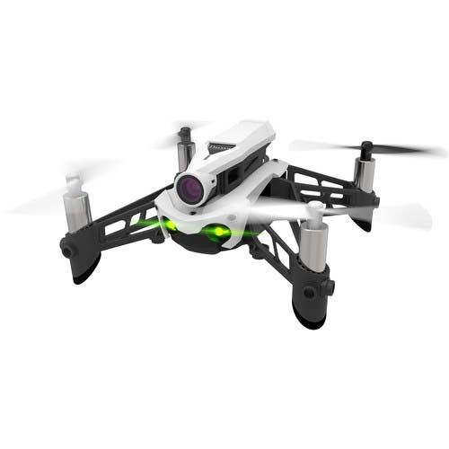
Sensors 2019, 19, 1379                                                                              5 of 13

3.2. Autonomous Navigation
     The drone should perform autonomous, vision-based navigation in order to solve the inventory
task. The drone’s state machine is designed to solve the task by splitting the drone operation into the
following states:

•     Take-off: This is the initial state of the drone when it starts its flight.
•     Find start position: After taking off, the drone needs to identify the top-left book by combining
      image recognition to detect books and re-positioning to get the best position for image recognition.
      In detail, the drone changes the distance to the bookshelf to identify the starting position and
      then navigates to this position until the top-left book is in the center of the view. Then, the drone
      changes to the scanning state.
•     Scan: Depending on the layer, the drone scans books from left to right or right to left. The altitude
      is lowered when one layer is totally scanned.
•     Finish: When no more shelf layers are left, the drone lands.

     The drone uses various movement behaviors to assure that a stable position can be maintained as
demanded by the states. Naturally, the outcome of the inventory task heavily depends on the methods
used for image detection. We will detail the implementation of navigation and image recognition in
Section 4.3.

4. Architecture Description and Implementation
     Any drone application requires control of flight behavior in order to support the specific
task of the drone. Traditionally, autonomous flight behavior is implemented on the drone in
order to avoid delays and to access the auto-pilot directly. Yet, this architecture limits the
computation capabilities; thus, we follow a novel direction in drone application design by proposing a
distributed architecture.

4.1. Distributed Architecture
     With a distributed design, we aim at overcoming the limitations of small-footprint embedded
processors on drones. This comes with the advantage of speeding up algorithms that require substantial
resources such as machine learning and image recognition. Our first design decision is to distribute the
drone logic between the drone and a remote computer with more advanced computation capabilities,
keeping only low-level piloting at the drone. A second design decision originates from our aim to
support human-drone teams; thus, we require a mobile computer or interface for including the human
in the team. Finally, the drone’s task is to support the remote logic with sensor-based input data, which
have to be generated by the drone.
     Figure 2 visualizes a concrete case of such a distributed architecture, capable of supporting the
use case bookshelf inventory described in Section 3. The drone captures and sends video data using
the on-board FPV (first person view) camera, performs flight maneuvers, and sends status information
about the current directional speed. A smartphone app receives the drone’s information, evaluates the
image and status data of the drone, and sends back flight commands. In addition, the smartphone
app provides voice recognition and a touch interface to allow the human team-mate to issue flight
commands and displays the progress of the scanning task. The communication technology is Wi-Fi
due to the large bandwidth required for video transmission; standard TCP/UDP messages are used to
communicate with the drone. The drone provides the Wi-Fi network and acts as an access point and
DHCP server. The smartphone connects to the Wi-Fi network as a client device. Image recognition is
performed on the smartphone (note that the concept of the distributed architecture is not limited to
smartphones, camera input, or to the sample use case).
Sensors 2019, 19, 1379 6 of 13
Flight commands Voice
Touch
Drone status, video
Drone Wi‐Fi Smartphone Human
Executes flight commands TCP/UDP Executes navigation logic Issues flight
Provides video using FPV camera Provides image recognition commands
Provides status (inertial sensors) Provides UI Views results
Figure 2. Distributed architecture for human-drone teaming in the concrete case of a camera-equipped
drone and a smartphone app providing the user interface for the human.
The interaction process between the human and the drone is designed in a way that the human
can interrupt the drone’s autonomous navigation and change to manual navigation at any point
in time. Manual navigation is possible by voice and touch input. When voice input is turned-on,
predefined voice commands (i.e., up/down, forward/backward, and left/right) are received through
the smartphone’s microphone and interpreted in the app by leveraging Android’s voice recognition
service. In addition to voice input, the human team-mate may employ the smartphone as a remote
flight controller by pressing buttons of the smartphone app. By interacting with the drone, the human
may support sophisticated navigation tasks, such as finding the bookshelf of interest in a room.
Whereas this is an easy task for the human, it requires semantic knowledge about the room objects and
advanced vision-based navigation by the drone.
4.2. Timing
A consequence of the distributed architecture is the more complex timing and message transfer
needed, as depicted in Figure 3. The drone sends status information to the smartphone at a constant
rate of R_inertial as well as a video stream at a rate of about R_video, which is an H264-specific video
rate. Upon reception of a frame that is part of the video stream, the smartphone app analyzes the frame
by performing image recognition and may send a flight command back to the drone when needed
after a processing delay of T_image. Yet, flight commands can also be triggered by a human at any
point in time. The time it takes for receiving information about the effect of the flight command is
defined as T_response. The control loop has to consider image information, but also T_image and
the expected T_response in order to count-in ongoing drone movement that happens in parallel with
control decisions.
1 1
R_inertial R_video
Drone
Inertial sensor values
Flight command
Flight command
Video frames
Smartphone
User input
T_image T_response
Time
Figure 3. Times to consider in a vision-based distributed navigation system: Inertial sensor values are
sent periodically from the drone to the smartphone, as well as video frames. After processing an image,
the navigation logic decides upon the next flight maneuver and sends a flight command to the drone.
At any point in time, the human user may interfere and send an overruling flight command to the
drone via interacting with the smartphone.Sensors 2019, 19, 1379 7 of 13
4.3. Implementation
In this section, we detail the hardware and software employed in the distributed system, how
vision-based navigation control is implemented, and messaging between the remote app software and
the drone.
4.3.1. Hardware and Software
A developer drone is required that is capable of communicating wirelessly with any computer,
providing basic piloting functionality for indoor flights upon reception of commands, and sending
back status information and video streams for further processing. Among the possible drones, the
Parrot Mambo provides the properties needed. Table 1 summarizes the basic hardware and software
capabilities of the drone. This quadcopter is easy to operate, can be equipped with an FPV camera
of sufficient resolution, and is light-weight. With the FPV camera, Wi-Fi is supported and can be
leveraged for communication.
Table 1. Overview of the testbed drone hardware and software.
Size, Weight CPU Sensors Lifetime Software
Quadcopter 180 × 180 × 40 mm, 800 MHz pressure, gyroscope 10 min, firmware v3.0.17
Parrot Mambo 70 g (with battery) ARM 3-axis accelerometer, 660 mAh
processor vertical camera
The user interface, image and text recognition, and autonomous trajectory calculation are
performed by an app running on a smartphone. The smartphone provides sufficient processing
power for vision-based navigation. The app further provides voice recognition and a touch-based
interface, which allows the user to manually navigate the drone, e.g., when the drone is not able
to find the correct position for scanning. User commands are executed with the highest priority,
meaning they overrule autonomous navigation. The app is developed to run on any Bluetooth- and
Wi-Fi-enabled smartphone running Android Versions 4.4–8.1. The app was successfully run on four
different smartphone platforms, among them a Samsung Galaxy S5 (CPU quad-core with 2.5 GHz,
2 GB RAM, Bluetooth, and IEEE 802.11n/ac).
The app is a Java-based custom-developed Android app leveraging the Parrot developers’ classes
available to connect from an Android application to the drone using TCP (https://github.com/
Parrot-Developers/Samples/blob/master/Android/). The OpenCV library is used to detect books
as rectangles (OpenCV library Release 3.4.1, http://opencv.org/). For text processing of book titles,
in the current implementation, the external API Tesseract OCR for Android is employed (Tesseract
library tess-two Version 5.4.1, https://github.com/rmtheis/tess-two/). Among possible other text
recognition options, this stands out as it can provide recognition without connecting to a remote server.
All results, as well as flight information are saved persistently on the smartphone’s memory.
4.3.2. Image Recognition and Drone Navigation Control
The core parts of the application running on the smartphone are image recognition and drone
navigation control. Image recognition takes the camera picture sent by the drone to identify books as
rectangles. The output of the application is a scanning result consisting of the number of scanned
books and an estimate of book titles. Beyond counting books, image recognition is at the same time
leveraged for drone navigation control.
The remote navigation algorithm implements the state model introduced in Section 3 as follows:
(i) first, the drone is positioned at the start position for scanning; (ii) then, it is commanded to scan a
bookshelf layer by layer; and (iii) it is commanded to land when finished. To determine the drone’s
position and to give a command for the next drone movement, the algorithm takes the camera images
sent by the drone as input, leverages image detection to detect rectangles, analyzes the position ofSensors 2019, 19, 1379 8 of 13
the rectangles on the image area, and bases the next movement on the result of image and geometry
analysis.
The process of image recognition runs in parallel to the other drone activities. Obstacles that
have the contour of a rectangle with a book shape are detected as books characterized by four
vertices, 90 degree angles, two opposite sides of equal length, and fulfilling a configurable constraint
concerning the relation between the length and the width of the rectangle, see Section 3 for the specific
configuration. The outcome of image processing is not only important for counting books, but also
provides input for drone navigation decisions that are vision-based. Remote drone navigation control
performs the following steps depending on the drone’s state:
• Take-off: In this state, the drone is commanded to move up until a configurable height is reached.
In the current implementation, it is assumed that the drone is positioned manually by the user
so that the orientation of the drone is towards the bookshelf of interest. Note that correcting
the orientation of the drone is a typical example of human intervention, which allows avoiding
time-consuming autonomous search for the correct bookshelf in the hall.
• Find start position: The aim is to detect the top-left book and to stabilize when the book is in the
center of the camera view. The movement of the drone is controlled accordingly. First, the drone
is commanded to increase the distance to the shelf in order to detect the top-left book (no other
books scanned higher, no other books scanned more left), then it moves up and left to stabilize
with the top-left book at the center of the image (blurring of 10% is calculated in). If the shelf is
too high, the human user may again help and navigate the drone to a position where the upper
left corner of the shelf can be detected in the image. To reach this stable position, both back and
forward and right and left movements are performed autonomously. Due to moving too far to the
left or right (or up or down), it may take some time to stabilize. This state is left to the scanning
state when the top-left book is in the center of the camera image.
• Scan: In this state, the drone is commanded to scan the books in one layer from left to right and
in the next layer from right to left, and so on. The altitude is lowered when one layer is totally
scanned, which requires again a positioning of the drone to center on the first book of the new
layer. After this movement is finished and the drone is stable, it starts scanning the books in the
particular layer and counts all books found. During scanning, the drone aims to keep a distance
that is optimal for scanning the book titles as well. The distance is kept by evaluating the ratio of
the book size to the overall picture size. If the book is too large, the distance is too small, and the
drone has to zoom out by flying backwards, and vice versa. The current configuration settings
aim for a book size of 20–30% of the picture size required for a stable distance.
• Finish: This is the end state of the algorithm. When no layer is left, the drone is commanded
to land.
To achieve the desired drone behavior, the remote navigation control algorithm sends flight
control messages to the drone, which, after a transmission delay, are executed by the drone.
4.3.3. Flight Control Messages
Flight control messages are used to interface between the smartphone app and the drone. These
high-level control messages are based on the Parrot messaging API. Hereby, sending messages is
either forced by the navigation control algorithm or by the human through the app. A flight command
consists of a tuple of parameters describing the speed and angle of movement in 3D along the
traditional axis of an aircraft: pitch, yaw, and roll. The parameters are packed into a flight command
and sent via a TCP message to the copter. The copter will perform a 3D movement according to the
flight command (i.e., moving up/down, forward/backward, or left/right).
On the smartphone, command processing includes autonomous generation of the flight
commands based on the status of the drone, its current position, and a calculation of the required
movement to reach the next position as determined by the task. In addition, flight commands areSensors 2019, 19, 1379 9 of 13
generated when the user takes over control and navigates the drone. On the drone, safe and reliable
flight command processing is provided by Parrot’s on-board control logic, which is responsible for
controlling the rotors to achieve the movement specified by the flight command. In return, the actual
flight characteristics of the copter are sent back to the smartphone app using the same set of parameters.
The parameters are:
• Gaz: With this parameter, the vertical speed is adjusted, leading to a change of throttle (rotor
movement) on the copter and an upward (downward) movement. It is expressed as a percentage
of the maximum vertical speed.
• Pitch: This parameter describes the angle towards the sky/ground, expressed as a percentage of
the maximum angle. By adjusting the pitch, forward (pitch towards the ground) or backward
(pitch towards the sky) movement is achieved.
• Roll: The roll angle expresses the tilt of the copter, again expressed as a percentage of the maximum
possible tilt of the copter. The roll angle controls side movements of the copter, i.e., moving to the
right or to the left.
• Yaw: This parameter controls the heading and is expressed as a percentage of the maximum yaw
rotation speed.
5. Experiments and Results
We are mainly interested in investigating the timing behavior and book detection quality.
To discuss these characteristics, we conducted experiments with our testbed consisting of one drone
and one smartphone and present the collected measurement results.
5.1. Experiment Setup
All experiments are executed with the off-the-shelf drone Parrot Mambo. The drone provides
the Wi-Fi network, while the human team-mate connects to the drone using an Android smartphone.
Basic latency tests are performed with a custom ping utility running on the smartphone, while the
task-specific experiments are performed using the inventory scanning app. During the task-specific
tests, the drone also streams video to the smartphone.
Three different experiments are conducted to investigate the following characteristics:
• Latency and reliability: With the ping utility program, ICMP (Internet Control Message Protocol)
packets are sent to the drone over a period of five minutes. This experiment aims to investigate
the basic latency and reliability of the Wi-Fi connection.
• Command response time: The drone is commanded to go up with a speed of 20% and then
down with the same speed of 20% (meaning 20% of the maximum drone speed of up to 30 km/h).
This experiment is repeated ten times. Overall, 20 flight command messages are sent setting
the up (down) speed to gaz = 20 (gaz = −20); see Section 4.3 for details of the flight command
messages. For each of the 20 commands sent, the response time is measured. Each command is
executed for two seconds. As the drone sends status information back with a rate of 1/500 ms−1 ,
we investigate the effect in two command frequency settings: (i) same command frequency: here,
a new command is sent every two seconds; we expect a synchronization effect due to the fixed
command response frequency; and (ii) random command frequency: in this setting, sending of
commands is triggered with a random rate, where the inter-command time is equally distributed
in the interval of [2, 2.5] s.
• Quality of recognition: This test is performed to give first insights about book recognition
performance in the distributed architecture and the effect of positioning. In the experiment, a
poster is leveraged to mimic a bookshelf. This is a simplification of a real library setting and thus
exhibits limitations, yet it is advantageous for reasons of reproducibility. The poster contains three
layers of books; book spines are of different colors; and titles vary in font size. We exemplify theSensors 2019, 19, 1379 10 of 13
effect of distance between the drone and the book shelf and discuss these insights qualitatively.
We examine three different distances: 0.5 m, 1 m, and 1.5 m. The number of correctly identified
books is measured.
5.2. Latency, Reliability, and Command Response Time
The latency is measured in terms of RTT (round trip time). The smartphone is placed 1.5 m away
from the drone, connected to the drone Wi-Fi network, and sends ICMP messages of a size of 64 bytes
to the drone. The experiment lasts about five minutes; 286 messages are transmitted. The results show
a stable Wi-Fi connection with 0% loss. The average RTT is 10 ms (minimum: 1 ms, maximum: 110 ms,
standard deviation: 10.1 ms). Figure 4a depicts the measured RTT values and the average.
+
Command response time (ms)
+
1500
100
80
1000
RTT (ms)
60
+
+
40
+
500
+
Average
20
+ +
+
+ +
+ + + + + +
+ +++++ + +++++++ ++++++++ ++++++++++++++++++++ +++++++++++++++++++++++++++++++++ +++++++++++++++++++++++++++++++ ++++ ++
++
+ +
+ +++
++ +
+ + ++
+ ++ +
+ + + +++ ++ +++ +
+
++ + + ++++++++++ + ++++ ++ + ++ +++ ++ +++++++++ + +++ ++++++++++++++ + +
+ +++ +
+++ +
++++ + ++++++ ++
+ + + + ++ +++++++ ++++++
+++++
+ +
+ + + ++ ++ ++ + + + ++++
+
+ +
0
0
0 50 100 150 200 250 Same Random
ICMP sequence Command frequency
(a) (b)
Figure 4. Investigation of delays: (a) RTT (round trip time) recorded over a period of five minutes
(286 ICMP messages) and (b) command response time with a constant inter-command time of 2 s
(same frequency) and an inter-command time randomly distributed in the interval of [2, 2.5] s (random
frequency). The red middle line in the box plots corresponds to the median, and the upper and lower
borders of the box visualize the 25% and the 75% quartiles, respectively.
The measured response times show that with the default setting of sending drone status
information every 500 ms and sending commands to the drone with a random rate the mean delay
is 376.1 ms (594.1 ms in the case of a constant command rate). It is worth mentioning that there were
rare cases in which the command took a few response cycles until the expected confirmation was
received with a delay of up to 1595 ms (constant command rate), which may lead to over-reactions in
the automatic control loop. Figure 4b and Table 2 detail the measurement results.
Table 2. Overview of command response time results.
Experiment Median Mean Variance Min Max
Same frequency 518.5 ms 594.1 ms 65.7 ms 481 ms 1595 ms
Random frequency 351.5 ms 376.1 ms 29.3 ms 106 ms 661 ms
5.3. Inventory Task: Qualitative Discussion
While the basic functionality of book and text recognition is working, the success rate of identifying
books heavily depends on the capabilities of image processing, which is currently the limiting factor.
As visualized by Figure 5, only a fraction of the books on the poster were detected, even when
positioned at the best spot . The success rate does not improve by moving along the optimal trajectory
for scanning; thus, the navigation algorithm is not the cause of the low success rate. (Note that in
the screenshots, the whole bookshelf fits in one image frame for reasons of visualization. This is not
required by the detection algorithm.)Sensors 2019, 19, 1379 11 of 13
App screenshot: 0.5 m distance App screenshot: 1 m distance
App screenshot: 1.5 m distance
Figure 5. Visualization of book detection results marked as red rectangles, observed at three
different distances.
The experiments indicate that distance has a high impact on the number of books that can be
detected. Table 3 summarizes the results of one experiment, i.e., the amount of books found at each
distance and the decrease of success related to the best scan result at 0.5 m. A significant decrease to
0.64 (0.45) at a distance of 1 m (1.5 m) demonstrates the impact of distance on detection success (the
results of text processing are not discussed here, as they were not convincing due to the limitation of
the text recognition library).
Table 3. Number of books found in the experiment poster shelf containing 66 books at different
distances (including the detection rate). The detection rate in the last column is the number of books
found related to the number of books detected in the best case of our experiments, i.e., 33 books at a
distance of 0.5 m.
Distance Number of Books Found Detection Rate Related to Best
0.5 m 33 (0.5) 1 (best)
1m 21 (0.32) 0.64
1.5 m 15 (0.22) 0.45
6. Conclusions
This paper presents a distributed architecture for human-drone teams in which the
computationally-intensive task of image recognition is off-loaded from the drone to a smartphone.
The smartphone further provides an interactive app with speech recognition and a touch interface
for human–drone interaction. Flight-control decisions are not taken on-board the drone, but on the
smartphone where images recorded by the drone’s camera are processed to determine next flight
maneuvers. We demonstrated the feasibility of the concept by a prototypical implementation of the
architecture applied to the sample task of book inventory. Our first experiments reveal that the average
network latency is as low as expected from a direct aerial Wi-Fi link (10 ms), and the command response
time is a few 100 s of ms on average. Yet, we experienced artifacts with a command response time of
above 1.5 s, which may be critical to perform accurate positioning. With the current implementation,
image recognition is the limiting factor. Yet we could demonstrate that the distance to the bookshelf
has a notable impact on book recognition. In our future work, we will extend the experiment-basedSensors 2019, 19, 1379 12 of 13
study of the timing behavior of the distributed architecture and will also work on improving the limits
identified concerning image recognition.
Author Contributions: Conceptualization, methodology, validation, investigation, writing (all parts),
visualization, and supervision: K.A.H.; conceptualization, software, and writing (some parts): M.P.; software
implementation, investigation, visualization, and writing (some parts): J.K.
Funding: The project work has been supported by materials and basic technical support of the Department of
Telecooperation, JKU Linz.
Conflicts of Interest: There is no conflicts of interest. The founding sponsors had no role in the design of the
study; in the collection, analyses, or interpretation of the data; in the writing of the manuscript; nor in the decision
to publish the results.
References
1. Andre, T.; Hummel, K.A.; Schoellig, A.P.; Yanmaz, E.; Asadpour, M.; Bettstetter, C.; Grippa, P.; Hellwagner, H.;
Sand, S.; Zhang, S. Application-driven design of aerial communication networks. IEEE Commun. Mag.
2014, 52, 129–137. [CrossRef]
2. Asadpour, M.; den Bergh, B.V.; Giustiniano, D.; Hummel, K.A.; Pollin, S.; Plattner, B. Micro aerial vehicle
networks: An experimental analysis of challenges and opportunities. IEEE Commun. Mag. 2014, 52, 141–149.
[CrossRef]
3. Asadpour, M.; Giustiniano, D.; Hummel, K.A.; Egli, S. UAV Networks in Rescue Missions. In Proceedings
of the 8th ACM International Workshop on Wireless Network Testbeds, Experimental Evaluation and
Characterization (WiNTECH ’13), Miami, FL, USA, 30 September–4 October 2013; ACM: New York, NY,
USA, 2013; pp. 91–92. [CrossRef]
4. Dedousis, D.; Kalogeraki, V. A Framework for Programming a Swarm of UAVs. In Proceedings of the 11th
PErvasive Technologies Related to Assistive Environments Conference (PETRA ’18), Corfu, Greece, 26–29
June 2018; ACM: New York, NY, USA, 2018; pp. 5–12. [CrossRef]
5. Khosrowjerdi, H.; Meinke, K. Learning-based Testing for Autonomous Systems Using Spatial and Temporal
Requirements. In Proceedings of the 1st International Workshop on Machine Learning and Software
Engineering in Symbiosis (MASES 2018), Montpellier, France, 3 September 2018; ACM: New York, NY, USA,
2018; pp. 6–15. [CrossRef]
6. Bregu, E.; Casamassima, N.; Cantoni, D.; Mottola, L.; Whitehouse, K. Reactive Control of Autonomous
Drones. In Proceedings of the 14th Annual International Conference on Mobile Systems, Applications, and
Services (MobiSys ’16), Singapore, 25–30 June 2016; ACM: New York, NY, USA, 2016; pp. 207–219. [CrossRef]
7. Mottola, L.; Whitehouse, K. Fundamental Concepts of Reactive Control for Autonomous Drones. Commun.
ACM 2018, 61, 96–104. [CrossRef]
8. McGuire, K.; Coppola, M.; de Wagter, C.; de Croon, G. Towards autonomous navigation of multiple
pocket-drones in real-world environments. In Proceedings of the 2017 IEEE/RSJ International Conference
on Intelligent Robots and Systems (IROS), Vancouver, BC, Canada, 24–28 September 2017. [CrossRef]
9. Cheng, Z.; West, R.; Einstein, C. End-to-end Analysis and Design of a Drone Flight Controller. CoRR 2018, 37,
2404–2415. [CrossRef]
10. Patelli, A.; Mottola, L. Model-based Real-time Testing of Drone Autopilots. In Proceedings of the 2nd
Workshop on Micro Aerial Vehicle Networks, Systems, and Applications for Civilian Use (DroNet ’16),
Singapore, 26 June 2016; ACM: New York, NY, USA, 2016; pp. 11–16. [CrossRef]
11. Chaumette, S.; Guinand, F. Control of a Remote Swarm of Drones/Robots Through a Local (Possibly Model)
Swarm: Qualitative and Quantitative Issues. In Proceedings of the 14th ACM Symposium on Performance
Evaluation of Wireless Ad Hoc, Sensor, and Ubiquitous Networks (PE-WASUN ’17), Miami, FL, USA, 21–25
November 2017; ACM: New York, NY, USA, 2017; pp. 41–45. [CrossRef]
12. Pandey, P.; Pompili, D.; Yi, J. Dynamic Collaboration Between Networked Robots and Clouds in
Resource-Constrained Environments. IEEE Trans. Autom. Sci. Eng. 2015, 12, 471–480. [CrossRef]
13. Salmeron-Garcia, J.; Inigo-Blasco, P.; del Rio, F.D.; Cagigas-Muniz, D. A Tradeoff Analysis of a Cloud-Based
Robot Navigation Assistant Using Stereo Image Processing. IEEE Trans. Autom. Sci. Eng. 2015, 12, 444–454.
[CrossRef]Sensors 2019, 19, 1379 13 of 13
14. Jensen, W.; Hansen, S.; Knoche, H. Knowing You, Seeing Me: Investigating User Preferences in Drone-Human
Acknowledgement. In Proceedings of the 2018 CHI Conference on Human Factors in Computing Systems
(CHI ’18), Montreal, QC, Canada, 21–26 April 2018; ACM: New York, NY, USA, 2018; pp. 365:1–365:12.
[CrossRef]
15. Avila, M.; Funk, M.; Henze, N. DroneNavigator: Using Drones for Navigating Visually Impaired Persons.
In Proceedings of the 17th International ACM SIGACCESS Conference on Computers and Accessibility
(ASSETS ’15), Lisbon, Portugal, 26–28 October 2015; ACM: New York, NY, USA, 2015; pp. 327–328. [CrossRef]
c 2019 by the authors. Licensee MDPI, Basel, Switzerland. This article is an open access
article distributed under the terms and conditions of the Creative Commons Attribution
(CC BY) license (http://creativecommons.org/licenses/by/4.0/).You can also read