A new empirical approach to evaluating fire weather risk to severe-extreme wildfires - 2019 Fire Behavior and Fuels Conference ...
←
→
Page content transcription
If your browser does not render page correctly, please read the page content below
Proceedings for the 6th International Fire Behavior and Fuels Conference
April 29 – May 3, 2019, Marseille, France USA
Published by the International Association of Wildland Fire, Missoula, Montana, USA
A new empirical approach to evaluating fire weather risk
to severe-extreme wildfires
Nicholas Gellie1*, Bruno Guillaume2
1
Ecofuego, Roimil-Friol, 27229, ecofuego.au@gmail.com
2
EFECTIS, Bordeaux, 33800, France, bruno.guillaume@efectis.com
Keywords: equilibrium moisture content, wind speed, hourly weather, energy release
component, critical fire weather parameters, fire growth
Introduction
In a risk management framework, analysis of fire risk is based on:
• hazard (occurrence/probability and severity);
• impact (vulnerability x exposure to hazard)
In this paper we focus on the hazard aspects using historical exposure to severe-extreme fire
weather to estimate likelihood of an event (severe-extreme bushfire) and its severity (duration
of severe-extreme fire weather conditions) based on hourly fire weather data for at least 20-
30 years, if not longer if the data can support the analysis. This is our objective we wish to
understand.
To do this we analysed the exposure to such fire risk conditions using hourly fire weather
records from representative weather stations in each region that have high quality weather
records. Equilibrium fine fuel moisture content (EFFMC), average wind speed, and energy
release component (ERC) are three key fire weather risk factors, derived using a suite of
publicly available equations in the United States Fire Danger Rating System (USFDRS)
(Deeming, Burgan et al. 1977), the Canadian Fire Weather Index (Van Wagner 1987) of the
Canadian Fire Danger Rating System (CFDRS) and the Grassland Fire Danger index (GFDI)
in the Australian Fire Danger Rating System (AFDRS) (Cheney, Gould et al. 1998). We
applied these empirical relationships to the dominant most hazardous fuel type in a bushfire
region. Secondly, we defined critical thresholds of the three factors into a new empirical
relationship describing the historical hazard to severe-extreme fire environment conditions.
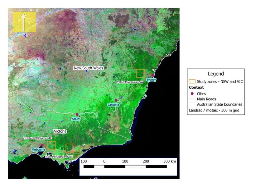
We applied this approach to estimating historical hazard three bushfire risk zones in south-
eastern Australia 50x 50 km in size (Figure 1):
1. the Blue Mountains west of Sydney in the Sydney Sandstone region of NSW
2. the Yarra valley region east of Melbourne in southern central Victoria
3. Central Gippsland north of the Morwell-Traralgon basin
Bushfire zone 1 falls within eucalypt forest and woodland in the western central part of the
Sydney Basin, comprising woodland and dry sclerophyll forest, and occasional heathland on
dissected sandstone and siltstone plateaux and gorges. Bushfire zone 2 lies east of
Melbourne in the southern foothills of the Great Dividing Range. The zone has a mosaic of
dry, damp, and wet sclerophyll forest depending on aspect, soils, and elevation with higher
mountain ranges in the north-east part of the zone up to 1200 m. Bushfire zone 3 occurs
1Proceedings for the 6th International Fire Behavior and Fuels Conference
April 29 – May 3, 2019, Marseille, France USA
Published by the International Association of Wildland Fire, Missoula, Montana, USA
about 70-100 km further east of bushfire zone 2 in the southern part of the south-eastern
highlands of Victoria. This is a cooler climate zone at higher elevations (500-1000 m) than
in zone 2 (100-700 m) which supports a range of montane and sub-alpine eucalypt forest
types found at these higher elevations.
Figure 1: Locations of bushfire risk zones in south-eastern Australia. The boundaries of the bushfire risk zones are
outlined as orange rectangles
Methods
We designed the method so that it can be applied to most countries in the world, once the
user has available (1) the hourly weather data from remote automatic weather stations (station
latitude, date, hourly time of day, rainfall, temperature, relative humidity, wind speed and
direction, and solar irradiance) either measured at the station or inferred from these
measurements, as well as (2) the fire history and fire footprints from existing fire record
databases in fire agencies.
Step 1: Creating and cleaning the weather datasets
We identified the most representative weather station in each bushfire zone that had
continuous and complete 0.5 or 1-h fire weather datasets from automatic weather stations.
The weather data for each bushfire zone was then imported into an Excel spreadsheet as 0.5
or 1-h (hourly) data. Missing data records for each of the key fire weather attributes were
then infilled using either (1) averaging of the fire weather record the record before and after
the missing data record where there was one missing record or (2) matching the fire weather
records to a nearby weather stations if there were more than two successive empty weather
2Proceedings for the 6th International Fire Behavior and Fuels Conference
April 29 – May 3, 2019, Marseille, France USA
Published by the International Association of Wildland Fire, Missoula, Montana, USA
records. For zone 1 we selected Richmond AWS. For zone 2 we selected Melbourne Airport
and for zone 3 we selected Mount Moornapa.
Step 2 - Estimating Equilibrium Moisture Content (EMC) for 1-h, 10-h, 100-h, and 1000-h
fuels
Table 1 summarizes the basic algorithms used to estimate EMC for 1-h, 10-h, 100-h, and
1000-h fuels. Estimation of EMC is a dynamic process involving wetting and drying of fine
and coarse forest fuels. For the wetting process in 1-h surface dead fuels, we used the
algorithms for wetting in the calculation of fine fuel moisture content (FFMC) in the
Canadian Forest Fire Danger Rating System (CFFDRS) (Van Wagner 1993). For the drying
process we adapted the Van Wagner (1993) algorithms but substituted Simard’s EMC
equations (1968) as these were found to more applicable to EMCs of eucalypt litter in
eucalypt forests. In addition, the Byram and Jemison equation (Byram and Jemison 1943) for
the effect of surface solar irradiance on heating eucalypt litter was used where there was data
for solar irradiance in the AWS weather data. Surface solar radiation at right angles to the
ground was estimated using using the Bird spreadsheet (Bird 1981) and index matched to
each day within the 0.5 or 1-h weather data using Julian day number Solar irradiance was
also adjusted using cloud cover when it was available for the full dataset.
EMC-1h was updated hourly or half-hourly using rainfall, temperature, relative humidity, and
10- m wind speed entered into the above equations to estimate EMC at any time of the day or
night.
Estimation of Energy Release Component (ERC)
We also used the ERC as part of our new empirical approach to evaluating fire weather
exposure risk (Deeming, Burgan et al. (1977)). To calculate the ERC a range of constant
factors and variable factors are needed.
Table 1: Summary of the equations used to estimate EMC for 1-h, 10-h, 100-h, and 1000-h fuels
Variable Abbreviation Preferred Alternative Comments
Fuel Tf Byram and Wotton (2012) Wotton’s formula may contain
temperature Jemison (1943) some errors – does not calculate
(1943) all values correctly. The Byram
equation
Surface IrrS Bird (1981) No readily published alternative
Irradiance
Moisture effect PEFF Wotton (2009) Used grassland moisture
correction formulae as more
applicable than boreal forest ones
in CFFDRS
Equilibrium EMC-1h Simard (1968) Nelson (1984) Nelson’s model does not work at
Moisture extremes of moisture. Not
Content suitable for a bookkeeping
spreadsheet
EMC-10h Deeming, Burgan Nelson (1984) Nelson’s model does not work at
et al. 1977 extremes of moisture.
EMC-100h & Cohen (1985) Nelson (1984) We would prefer to use Nelson
EMC-1000h (1984) in the future
Desorption and KD Wotton (2012) Van Wagner These equations allow for an
Adsorption (1987) hourly adjustment for wetting
adjustments and drying. This can make a 2%
3Proceedings for the 6th International Fire Behavior and Fuels Conference
April 29 – May 3, 2019, Marseille, France USA
Published by the International Association of Wildland Fire, Missoula, Montana, USA
difference
Cloud Cover CCEFF Black (1956) Locally derived See also Sarkar (2016). Because
effect cloud cover surface irradiance ranges from 0-
effect models 1100 kW/m2
The constant factors are: (1) fuel type; (2) fuel loadings and weighted surface area to volume
ratios for the 1-h, 10-h, 100-h, 1000-h fuel live shrubs; (3) for 1-h and shrub fuels; and (4)
fuel bed depth
The variable factors are: moisture of 1-h, 10-h, 100-h, and 1000-h fuel calculated in a
separate spreadsheet as per the previous section and carried over in the ERC spreadsheet.
Determination and application of fire weather risk thresholds
We examined the fire literature to find evidence of a set of trigger thresholds for determining
the historical hazard risk to severe-extreme fires in a bushfire risk zone.
It became clear that the following set of fire weather and ERC thresholds could be used to
determine this:
• EMC-1h< 3-4%
• 10-m wind speed >30-40 km/h
• ERC>0.8 of ERC kW/m2 (Zone 1: > 50,000 kW/m2; Zone 2: >53,000 kW/m2; Zone3: >
100,000 kW/m2)
Below 5%, we found that ember and firebrand spotting become the predominant fire spread
propagation mechanism and potential loss and damage to human infrastructure and natural
ecosystem function. We then filtered the fire weather data using the above criteria. We then
introduced a further temporal filter of duration of number of hours when these criteria were
exceeded on a day. The idea behind this is the higher the number of hours on a fire day, the
higher is the potential exposure to a large bushfire. The data was then synthesized into a
contingency table of true and false positives, and correspondingly combined true and false
negatives.
Results
Table 2 shows the results of applying a combined set of fire weather and ERC thresholds for
the three bushfire zones in south-eastern Australia.
Bushfire zone one 1 has the highest percentage of severe-extreme fire weather conditions at
0.14% in the 29-year period. In both zone 2 and 3, the percentages are three to five times
lower than in zone 1. When the number of severe-extreme bushfire hours is expressed as a %
of afternoon daylight hours, the percentage rises to 0.8% in zone 1, and in zone 2 and 3 to
0.16 and 0.31% respectively.
Table 2: Comparative number and percentage of severe-extreme fire weather conditions for each
bushfire zone
4Proceedings for the 6th International Fire Behavior and Fuels Conference
April 29 – May 3, 2019, Marseille, France USA
Published by the International Association of Wildland Fire, Missoula, Montana, USA
Zone
Total no. of Duration
severe- of peak
Total extreme hour Total no. of
number of fire % of total period PM
No of hours in weather hours between (13:00- daylight % of PM daylight
Years period hours 1994 and 2017 18:00) hours hours
1 29 254,040 344 0.14% 6 42,340 0.81%
2 47 411,720 113 0.03% 6 68,620 0.16%
3 23 201,480 103 0.05% 6 33,580 0.31%
Table 3 summarizes the results using the applied fire weather risk thresholds of more than 3
hours duration of design conditions (EMC-1h = 30 km/h; ERC>0.8 of
maximum ERC). We find that there are 24 true positives (28% of 85 severe-extreme fire
weather days in the period from 1994 to 2018) when a bushfire has occurred within the
defined set of weather conditions. There were false positives (12.8% of severe-extreme fire
weather days in the period from 1994 to 2018) when there were no recorded bushfires on the
design days. There were 50 days (58.8%) of false and positive negatives when there were no
severe-extreme bushfires in zone 1.
Table 3: contingency table of number of true and false positives (>=4 hours duration of design conditions)
in the three bushfire zones, compared to true and false negatives (less than 4 h duration of design
conditions)
Bushfire No. (Proceedings for the 6th International Fire Behavior and Fuels Conference
April 29 – May 3, 2019, Marseille, France USA
Published by the International Association of Wildland Fire, Missoula, Montana, USA
Instead of a single value from a fire danger rating system, our alternative empirical approach
can drill the data for potential combinations of EMC-1h, WS-10m, and ERC based on any
criteria be it for extreme fire weather or prescribed burning conditions. This approach has
two aspects: first, the detailed 0.5 or 1-h fire weather record; and the second is the duration of
these ‘design’ conditions on any given fire weather day through out a given fire weather
record. This creates distinct combinations of EMC-1h, WS-10m, and ERC, which can be
compared to the whole of the historical weather record.
The data in Table 3 also provides the likelihood of a fire starting under a severe-extreme set
of fire weather conditions in the different bushfire zones. In zone 1 within the Blue
Mountains, a large bushfire is 4-7 times more likely to occur than in zones 2 and 3 in
Victoria. Secondly, the fire weather conditions in zones 2 and 3 need to be more extreme and
later in the fire season for an extreme bushfire to occur. This fits in with the concept of
‘tipping’ points used in climate science.
The next step in this empirical approach is to produce area growth statistics for bushfires in
each of the bushfire zones 1, 2, and 3. Cursory inspection of the fire growth data suggests
that the area growth is very much dependent on WS-10m once EMC-1h are below 3–4%.
There are two separate fire scenarios: (1) the rate of fire growth with WS-10m of 30-40 km/h
in dry sclerophyll forest can be 1300–1500 ha/h in all bushfire zones; (2) the rate of fire
growth can increase to 3,500–4,500 ha/h when the wind is in excess of 45-50 km/h (2009
Kilmore East in zone 2 or 2013 State Mine bushfire in zone 1).
Conclusions
We have managed to develop a proof in concept empirical approach utilising hourly or half-
hourly fire weather data to define a key part of historical hazard (exposure to severe-extreme
fire weather) in three bushfire zones in south-eastern Australia. Because of its generic
approach, the method can be used anywhere in the world. This method will clearly be largely
improved by examining the link between the probability of occurrence and likely fire sizes, in
order to get bushfire hazard characterisation (probability x severity).The benefit of this
approach is that we optimally use the basic underlying values of fuel and fire weather
conditions that drives large fires and captures their large variations at hourly scale in a fire
day, and the approach provides a common risk assessment framework that enables equal
comparisons of exposure to severe-extreme fire weather between any fire regions in the
world.
References:
Bird, R. E. and R. L. Hulstrom (1981). A Simplified Clear Sky Model for Direct and Diffuse
Insolation on Horizontal Surfaces. Golden, Colorado, USA, Solar Energy Research Institute.
Black, J. N. (1956). "The distribution of solar radiation over the Earth's surface." Archiv für
Meteorologie, Geophysik und Bioklimatologie, Serie B 7(2): 165-189.
Byram, G. M. and G. M. Jemison (1943). "Solar radiation and fuel moisture." Journal of
Agricultural Research 67(4): 149-175.
Cheney, N. P., et al. (1998). "Prediction of fire spread in grasslands." International Journal of
Wildland Fire 8(1): 1-13.
Cohen, J. D. (1985). The national fire-danger rating system: basic equations. Berkeley, CA:
U.S, Southwest Forest and Range Experiment Station. Rep. PSW-GTR-82: 16.
6Proceedings for the 6th International Fire Behavior and Fuels Conference
April 29 – May 3, 2019, Marseille, France USA
Published by the International Association of Wildland Fire, Missoula, Montana, USA
Deeming, J. E., et al. (1977). The National Fire Danger Rating System – 1978, USDA For.
Serv., Intermt. For. Range Exp. Stn., Ogden, Utah, Gen. Tech. Rep. INT-39: 63.
Nelson Jr, R. M. (1984). "A method for describing equilibrium moisture content of forest
fuels." Canadian Journal of Forest Research 14(4): 597-600.
Simard, A. J. (1968). The moisture content of forest fuels. I. A review of basic concepts.
Information Report FF-X-14, Forest and Fire Research Institute, Forestry Branch,
Department of Forestry and Rural Development, Ottawa, Canada: 47.
Van Wagner, C. E. (1987). Development and Structure of the Canadian Forest Fire Weather
Index System. Forestry Technical Report 35, Petawawa National Forestry Institute, Ontario,
Canadian Forestry Service, Ottawa.: 37.
Wotton, B. M. (2009). A grass moisture model for the Canadian Forest Fire Danger Rating
System. Eighth Symposium on Fire and Forest Meteorology. Kalispell, MT, American
Meteorological Society: Boston, MA.
Presenter’s bio:
Nic Gellie is a contract fire and vegetation scientist with a background in field fire research,
vegetation and fire ecology, and fire management. He has worked with the Forestry
Commission Tasmania, the National Parks and Wildlife Service of NSW, and the Department
of Sustainability and Environment in Victoria. He completed a Masters of Philosophy in
Science in 2009 at the Australian National University on the topic of Landscape
Susceptibility to Large Landscape fires. He has prepared reports on the fire behaviour of
extreme wildfires on Black Saturday 2009 in Victoria; reconstructed the spread of many
different wildfires in different fire environments in south-eastern Australia; analysed the
impact of prescribed burns on the spread and behaviour of extreme fires, and more recently
analysed fire weather risk factors in producing severe-extreme fires.
7You can also read