A ROADMAP FOR A SUSTAINABLE AGRICULTURAL WEATHER MONITORING NETWORK IN BC 2021 - Climate ...
←
→
Page content transcription
If your browser does not render page correctly, please read the page content below
A ROADMAP FOR A
SUSTAINABLE AGRICULTURAL
WEATHER MONITORING
NETWORK IN BC
2021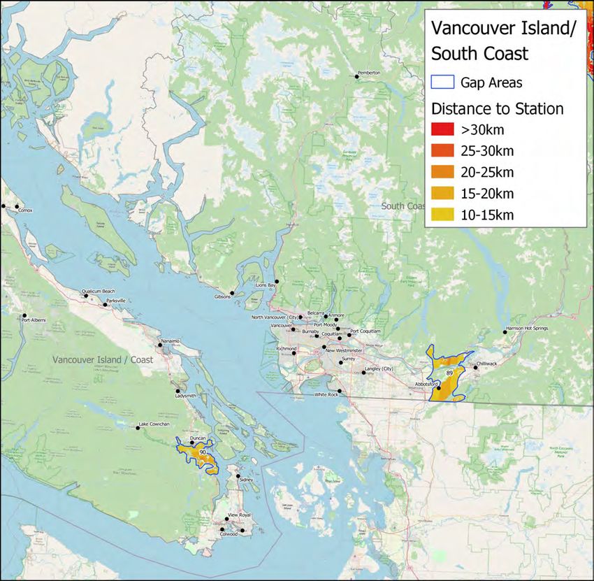
A Roadmap for a Sustainable Agricultural Weather Network in BC

                   Prepared by: Peak HydroMet Solutions

                   Published by: BC Agricultural Climate Adaptation Research Network and
                   Climate & Agriculture Initiative BC, 2021

Copyright                                    Citation Format                           Disclaimer
Copyright © 2021 BC Agricultural             In-text: Peak HydroMet 2021               Agriculture and Agri-Food Canada and the
Climate Adaptation Research Network                                                    BC Ministry of Agriculture, Food &
and Climate & Agriculture Initiative BC      Reference List: Peak HydroMet. 2021. A    Fisheries are committed to working with
                                             Roadmap for a Sustainable Agricultural    industry partners. Opinions expressed in this
Available to print and/or distribute under   Weather Network in BC. BC Agricultural    document are those of the author and not
a Creative Commons Attribution-              Climate Adaptation Research Network and   necessarily those of Agriculture and Agri-
NonCommercial-NoDerivatives 4.0              Climate & Agriculture Initiative BC.      Food Canada, or the BC Ministry of
International License.                       www.bcacarn.com                           Agriculture, Food & Fisheries. The
creativecommons.org/licenses/by-nc-          www.climateagriculturebc.ca               Government of Canada, the BC Ministry of
nd/4.0/                                                                                Agriculture, and their directors, agents,
                                                                                       employees, or contractors will not be liable
                                                                                       for any claims, damages, or losses of any
                                                                                       kind whatsoever arising out of the use of, or
                                                                                       reliance upon, this information.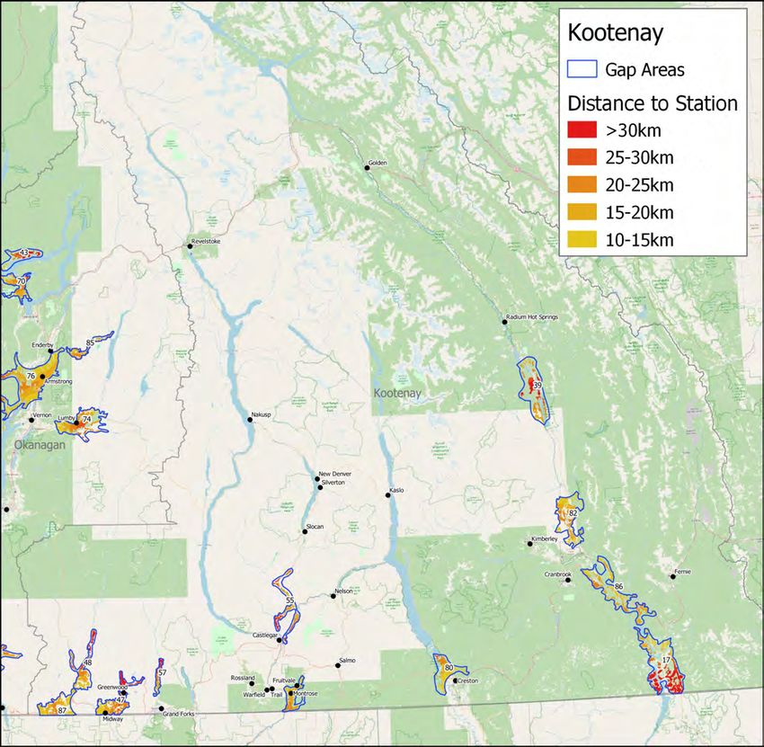
ACKNOWLEDGEMENTS

This report was prepared by Andrew Nadler of Peak HydroMet Solutions, in partnership with the BC
Agricultural Climate Adaptation Research Network (ACARN) and the Climate & Agriculture Initiative BC.

The project was initiated and guided by the BC ACARN Climate and Weather Data Working Group:

        •    Faron Anslow, Pacific Climate Impacts Consortium
        •    Shabtai Bittman, Agriculture and Agri-Food Canada, Agassiz
        •    Andrew Black, University of British Columbia
        •    Serena Black, University of Northern British Columbia
        •    Rishi Burlakoti, Agriculture and Agri-Food Canada, Agassiz
        •    Kirsten Hannam, Agriculture and Agri-Food Canada, Summerland
        •    Jason Lussier, BC Ministry of Agriculture, Food and Fisheries
        •    Shauna MacKinnon, BC Agricultural Climate Adaptation Research Network
        •    Emily MacNair, Climate & Agriculture Initiative BC
        •    Ian McLachlan, BC Ministry of Agriculture, Food and Fisheries
        •    Nathaniel Newlands, Agriculture and Agri-Food Canada, Summerland
        •    Sean Smukler, University of British Columbia
        •    Anna Stemberger, BC Ministry of Agriculture, Food and Fisheries
        •    Stephanie Tam, BC Ministry of Agriculture, Food and Fisheries

FUNDING

Funding for this project has been provided in part by the BC Agricultural Climate Adaptation Research Network
and in part by the governments of Canada and British Columbia under the Canadian Agricultural Partnership, a
federal-provincial-territorial initiative. Funding is administered by the Investment Agriculture Foundation of BC
and the BC Agricultural Research & Development Corporation for the Climate Change Adaptation Program
delivered by the Climate & Agriculture Initiative BC.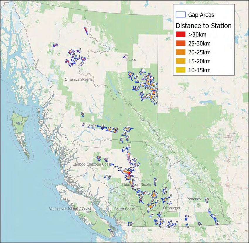
EXECUTIVE SUMMARY
Agriculture is facing unprecedented challenges due to climate change. Frequency of extreme events, abnormal
weather patterns, and the potential introduction of new pests require strategic adaptation to manage risk. The sector
also faces opportunities to adapt by implementing new and innovative production practices that can increase
resilience and make BC more competitive. Such adaptation can only be accomplished by having quantitative data
that will help us understand the changes that are occurring – and that will occur. Presently, this information is
inconsistent and incomplete, lacking the necessary spatial representation to effectively be used to inform agricultural
adaptation.

This report provides a roadmap, including actionable steps that can be taken to build a sustainable agricultural
weather monitoring program in British Columbia. The report includes: (1) the status of meteorological monitoring within
BC, (2) an assessment of agricultural areas that lack sufficient baseline coverage, and (3) recommendations for an
operational structure that builds on work to date, along with tangible action items for improving weather monitoring
and tools for agriculture in BC.

The gap analysis is focused on establishing a baseline level of weather data collection across the agricultural land
base of the province. The analysis reveals agricultural areas that have inadequate regional weather monitoring for
this baseline and that 90% of the total under-represented land are within the Omenica Skeena, Cariboo Chilcotin
Coast, and Peace regions. These relatively remote and less populated areas also have the largest expanses of
farmland used primarily as pasture for grazing. The baseline assessment suggests that adding a weather station to
each of the top 25 ranked areas would cover 80% of the total least represented farmland. Adding 34 new stations
would cover 90% of the least represented land. Broader baseline coverage would provide more robust information
about climate and weather across BC’s agricultural land base and would support more equitable regional-scale
monitoring.

The more populated areas tend to have adequate baseline coverage but would benefit from additional stations to
inform strategic and operational decisions, particularly for managing high value crops. A tiered methodology is
proposed whereby the types of farm management decisions will influence whether monitoring is at a regional, local,
farm, or field scale. Finding a balance between sufficient baseline coverage, while increasing the quality and
consistency of monitoring in the higher intensity agricultural areas, will help to achieve a range of objectives with the
agricultural weather network.

Several stakeholders are already collecting weather information to serve various needs within their regions or on
their own farms. This has resulted in a fragmented distribution of observational equipment and collection methods.
This report recommends an operational model that leverages and enhances these existing monitoring stations by
providing provincial coordination and support. This community-based monitoring strategy would empower
stakeholders by providing them with resources and expertise to manage their networks according to established
guidelines, and ensuring that networks adhere to hardware, siting, maintenance, and metadata standards. This will
result in measurements of known quality that can be used for multiple purposes. Centralized data management would
benefit all agricultural stakeholders by providing quality control, derivatives, and dissemination of value-added
information, including decision support tools. Central coordination would also help address the existing monitoring
gaps so that these areas can also benefit from improved weather information.

Based on its findings, this report recommends actions for implementation, including resources that are required to
achieve the stated objectives. This collaborative approach will require long-term resource commitments (budget and
dedicated personnel) to build and maintain a successful program.

iv                                A Roadmap for a Sustainable Agricultural Weather Monitoring Network in BC
PROPOSED BC AGRICULTURAL NETWORK STRATEGY

Proposed agricultural weather network and data handling strategy that includes different network operators and a provincially coordinated
          data management platform. Important components include metadata, data quality control, and decision support tools.

v                                    A Roadmap for a Sustainable Agricultural Weather Monitoring Network in BC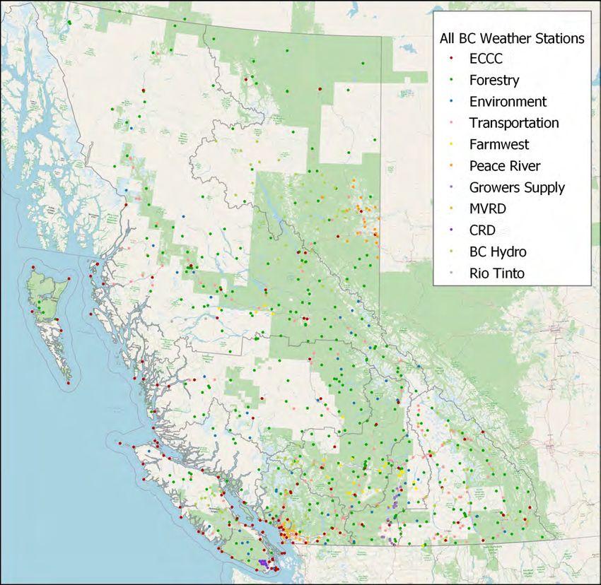
RECOMMENDATIONS

COMMUNITY-BASED MONITORING
The most effective way to enhance weather monitoring is to promote a community-based model that involves
participation in weather collection by different organizations and individuals. This decentralized approach improves
efficiency and costs by engaging local resources.

To increase the inventory of available weather data, existing weather stations should be evaluated for their
suitability for agricultural use based on monitoring standards and guidelines that need to be established. New
stations would also need to adhere to these guidelines. The station owner could be eligible to receive assistance for
hardware and data costs.

PROVINCIAL COORDINATION
Establish a formalized agricultural weather-specific entity that acts as a province-wide resource for existing and
potential weather station and weather network operators. This entity coordinates closely with regional interests to
provide support and resources. The entity would provide standards, guidelines, training, support, and a data
handling infrastructure that would serve the needs of agriculture and provide methodological consistency between
networks. A dedicated Network Coordinator should be appointed.

CENTRALIZED DATA PLATFORM
Develop and provide a central platform on which to process, manage, quality control (QC), model, and redistribute
weather information in a user-friendly manner. An effective QC is imperative. This would be a combination of
automated processes and human oversight. Every weather station and collected element must have sufficient
metadata. All agricultural weather network operators in BC should be required to also follow this standard for
documenting and reporting all monitoring details. A Data Technician is required to support this initiative.

DECISION SUPPORT TOOLS
Decision support tools (DSTs) help producers make informed decisions to improve efficiency, identify opportunities to
optimize production, reduce inputs, and increase profit. The data platform must include decision support tools that
serve different production types. Education and awareness are key components of any agricultural weather program.
Uptake of decision support tools will require training and support. Regional and local farm advisors and industry
groups can assist with this training.

HARDWARE
Some viable hardware options are identified. Stations that are less complex are ideal in that basic maintenance and
repairs can be performed by local resources instead of centralized dedicated technicians. Davis Instruments and
METER Group stations are well suited for such applications. All stations should collect a minimum of air temperature,
relative humidity, and rainfall. Ideally, stations will also collect wind speed and direction and solar radiation. Stations
that are used for disease prediction should have leaf wetness sensors. Information should be transmitted at least
hourly.

FUNDING
To succeed, a formalized agricultural weather program requires long-term and secure funding. This funding will go
towards establishing and maintaining the data platform, incorporating DSTs, and supporting network and station
operators with hardware and operational costs. Adequate funding will enable the program to become established
and to meet its short-term and long-term objectives.

vi                                A Roadmap for a Sustainable Agricultural Weather Monitoring Network in BC
ACRONYMS
 AAFC       Agriculture and Agri-Food Canada
 ACARN      British Columbia Agricultural Climate Adaptation Research Network
 ACIS       Alberta Climate Information System
 AEPI       Agriculture Environmental Partnership Initiative
 AFF        BC Ministry of Agriculture, Food and Fisheries
 API        Application programming interface
 ARM        Application Risk Management
 AWN        AgWeatherNet (Washington State University)
 BC DAS     BC Decision Aid System
 BCFC       BC Forage Council
 BRM        Business Risk Management
 BTM 1      Baseline Thematic Mapping – Present Land Use Mapping Version 1
 CAI        Climate & Agriculture Initiative BC
 CBM        Community Based Monitoring
 CHU        Corn Heat Units / Crop Heat Units
 CoCoRaHS   Community Collaborative Rain, Hail & Snow
 CRMP       Climate Related Monitoring Program
 CWOP       Citizen Weather Observing Program
 DST        Decision Support Tool
 EC         Environment Canada
 ECCC       Environment and Climate Change Canada
 EFP        Environmental Farm Plan
 ENV        Ministry of Environment and Climate Change
 ET         Evapotranspiration
 FLNRORD    Ministry of Forests, Lands, Natural Resource Operations and Rural Development
 GCOS       Global Climate Observing System
 GDD        Growing Degree Days
 GIS        Geographic information system
 IoT        Internet of Things
 IT         Information Technology
 IPM        Integrated Pest Management
 KDE        Kernel Density Estimation
 LPWAN      Low-power wide-area networking
 MoT        Ministry of Transportation and Infrastructure
 NoN        Network of Networks
 PCIC       Pacific Climate Impacts Consortium
 PFCA       Pacific Field Corn Association
 PCDS       Provincial Climate Data Set
 RFQ        Request for Quotations

vii                 A Roadmap for a Sustainable Agricultural Weather Monitoring Network in BC

RH      Relative Humidity
 SaaS    Software as a Service
 SCIC    Saskatchewan Crop Insurance Corporation
 SLA     Service-Level Agreement
 SIR     Sterile Insect Release Program
 UI      User Interface
 WIGOS   WMO Integrated Global Observing System
 WMO     World Meteorological organization
 WSU     Washington State University

viii             A Roadmap for a Sustainable Agricultural Weather Monitoring Network in BC
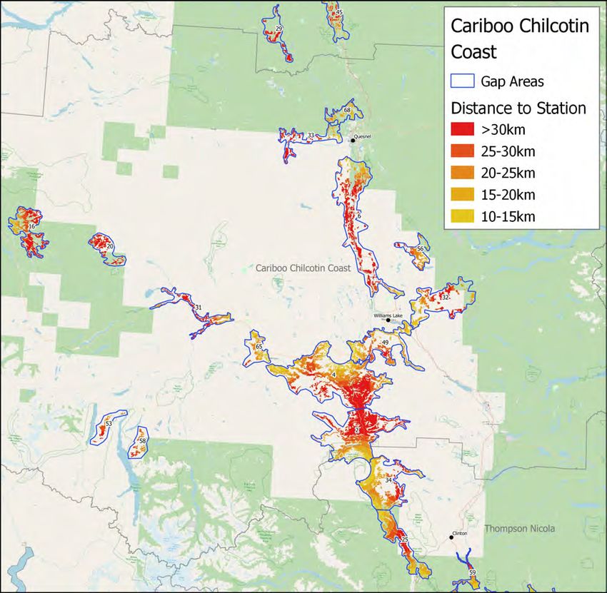
TABLE OF CONTENTS
Executive Summary .............................................................................................................................................................................. iv
Proposed BC Agricultural Network Strategy and Recommendations ......................................................................................... v
Acronyms ............................................................................................................................................................................................... vii
List of Figures ........................................................................................................................................................................................ xi
List of Tables ........................................................................................................................................................................................ xii
Introduction and Rationale................................................................................................................................................................... 1
Weather Monitoring in BC .................................................................................................................................................................. 2
     Scales of Monitoring ........................................................................................................................................................................ 4
     Agricultural Monitoring in BC ......................................................................................................................................................... 5
         Farmwest ....................................................................................................................................................................................... 5
         BC Peace Agri Weather Network ........................................................................................................................................... 6
         Okanagan Valley Network....................................................................................................................................................... 8
         Other Weather Stations ............................................................................................................................................................ 8
     Community Based Monitoring ........................................................................................................................................................ 9
     Agricultural Weather Networks Outside of BC ....................................................................................................................... 11
     A Coordinated Approach ............................................................................................................................................................ 12
Baseline Gap Analysis ...................................................................................................................................................................... 13
     Previous Work ............................................................................................................................................................................... 13
     Methods........................................................................................................................................................................................... 14
     Results .............................................................................................................................................................................................. 17
     How to use this Gap Analysis ..................................................................................................................................................... 22
Addressing the Gaps ......................................................................................................................................................................... 23
     Station Siting .................................................................................................................................................................................. 23
     Hardware ....................................................................................................................................................................................... 24
     Dataloggers and Communication ............................................................................................................................................... 24
     Measurements ................................................................................................................................................................................ 26
     Weather Station Hardware ........................................................................................................................................................ 29
         Weather Station Suitability ................................................................................................................................................... 32
     Station Maintenance and Upkeep ............................................................................................................................................. 33
Network Requirements ...................................................................................................................................................................... 34
     Quality Control .............................................................................................................................................................................. 34
     Metadata........................................................................................................................................................................................ 36
     Data Access and Discoverability ................................................................................................................................................ 37
     Data Preservation ......................................................................................................................................................................... 38
     Modelling and Derivatives .......................................................................................................................................................... 38

ix                                                       A Roadmap for a Sustainable Agricultural Weather Monitoring Network in BC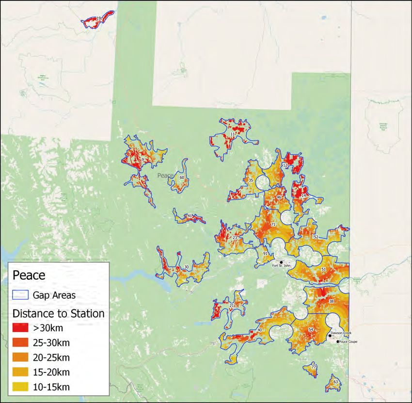
User Experience ............................................................................................................................................................................. 39
Data Management Platform ....................................................................................................................................................... 39
Extension ......................................................................................................................................................................................... 41
Decision Support Tools ...................................................................................................................................................................... 41
Types of Decision Support Tools................................................................................................................................................. 41
Strategic..................................................................................................................................................................................... 42
Tactical ....................................................................................................................................................................................... 43
Operational............................................................................................................................................................................... 44
Available Tools .............................................................................................................................................................................. 44
Decision Support Tool Portals ..................................................................................................................................................... 47
Stakeholder Feedback ................................................................................................................................................................. 48
Implementation.................................................................................................................................................................................... 49
Steering Committee ...................................................................................................................................................................... 50
Resourcing and Costs .................................................................................................................................................................... 51
Data Management ................................................................................................................................................................... 51
Weather Stations ..................................................................................................................................................................... 52
Station Operation and Maintenance.................................................................................................................................... 52
Personnel Costs ......................................................................................................................................................................... 53
Proposed Budget ...................................................................................................................................................................... 53
Conclusion ............................................................................................................................................................................................ 55
Recommendations ............................................................................................................................................................................... 56
Community-Based Monitoring ................................................................................................................................................ 56
Provincial Coordination ........................................................................................................................................................... 56
Centralized Data Platform ..................................................................................................................................................... 56
Decision Support Tools ............................................................................................................................................................ 56
Hardware .................................................................................................................................................................................. 56
Funding ....................................................................................................................................................................................... 56
References ........................................................................................................................................................................................... 57
Appendix A – Regional Maps of Sparse Coverage ................................................................................................................... 59
Appendix B - Stakeholder Feedback............................................................................................................................................. 67
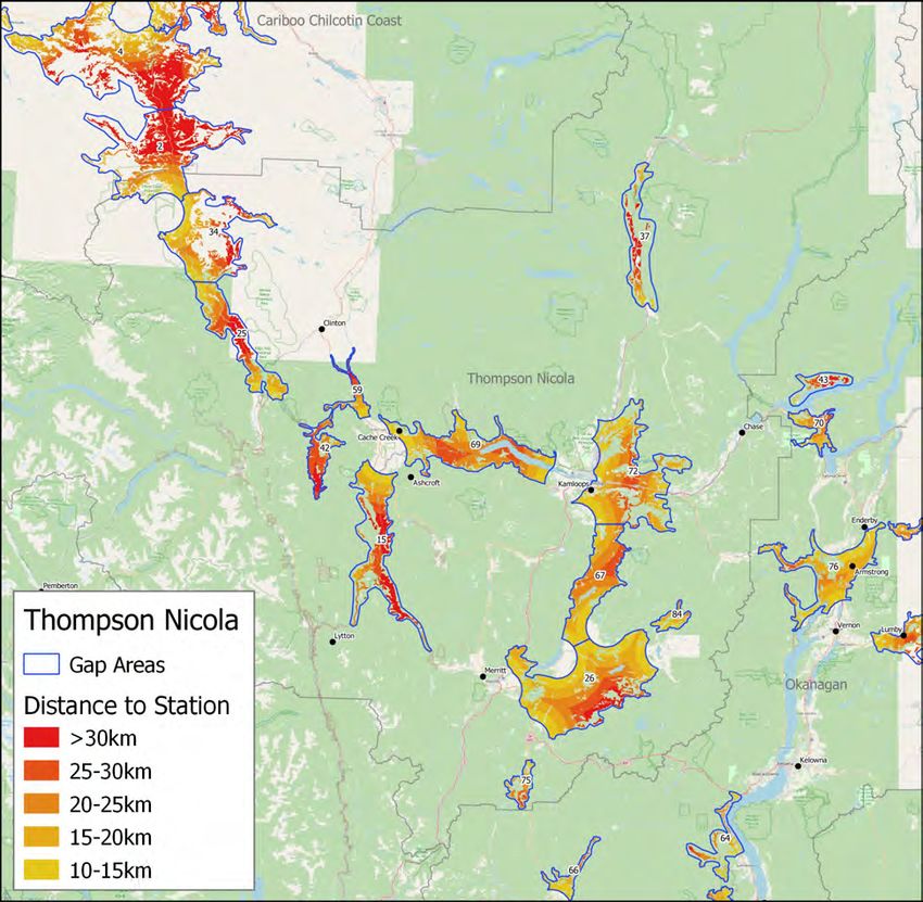
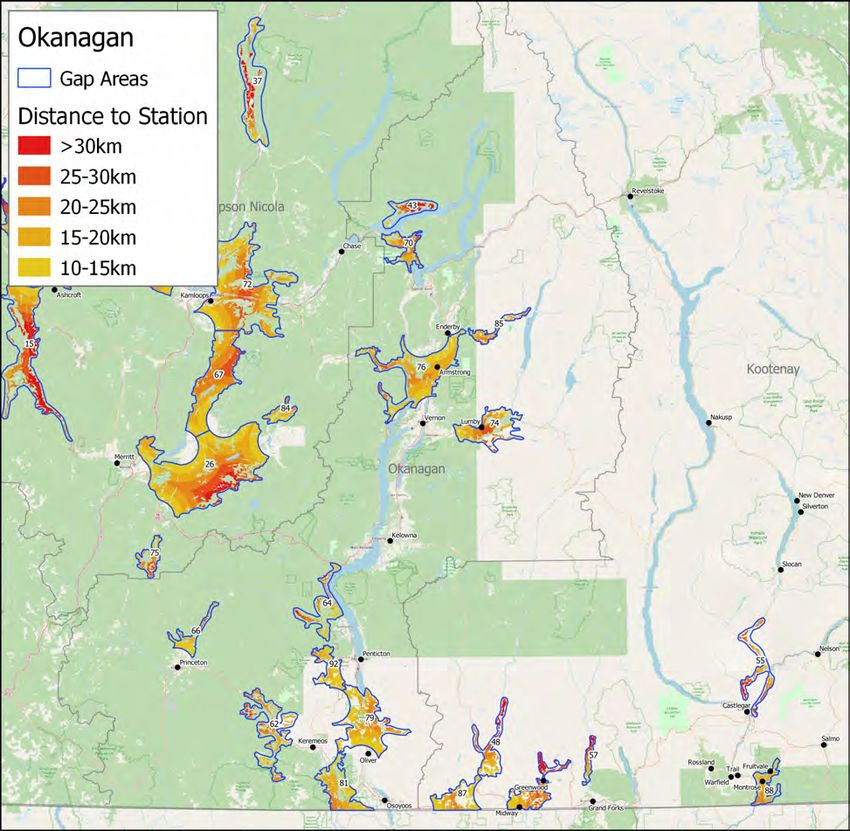
x A Roadmap for a Sustainable Agricultural Weather Monitoring Network in BCLIST OF FIGURES Figure 1: Composition of weather network operators in BC from 1950 to 2019 ................................................................... 3 Figure 2: Distribution and coverage of existing inter-agency weather networks across BC .................................................. 4 Figure 3: Farmwest weather station (Grand Forks) ........................................................................................................................ 5 Figure 4: Farmwest website showing daily temperature............................................................................................................... 6 Figure 5: BC Peace Agri Weather Network Station (Kelly Lake) ............................................................................................... 7 Figure 6: BC Peace Agri Weather Network Website showing historical station data ........................................................... 7 Figure 7: Davis WeatherLink stations in the Vanderhoof/Prince George areas and the Okanagan-Similkameen .......... 9 Figure 8: Vineyard weather station in the Okanagan-Similkameen ........................................................................................... 9 Figure 9: School Based Weather Station Network plot of total rainfall ................................................................................ 10 Figure 10: Community Collaborative Rain, Hail & Snow (CoCoRaHS) observations. ........................................................... 10 Figure 11: Washington State University’s AgWeatherNet program. ...................................................................................... 12 Figure 12: Heat maps showing areas of under-represented farmland .................................................................................. 16 Figure 13: Percent of under-represented farmland broken down by region ........................................................................ 17 Figure 14: Agricultural land beyond 15 km from a weather station ....................................................................................... 18 Figure 15: Areas identified as monitoring gaps, including their relative ranking ................................................................. 19 Figure 16: Farmland beyond 15 km and 30 km from an existing weather station .............................................................. 21 Figure 17: METER Group Atmos41/ZL6 (left) and Davis Instruments GroWeather (right) .................................................. 33 Figure 18: Pacific Climate Impacts Consortium Data Portal ...................................................................................................... 38 Figure 19: Scales of Decision Support Tools (based on Rossi et al. 2019)............................................................................. 42 Figure 20: BC Agriculture Water Calculator used to estimate crop and livestock water needs. ....................................... 43 Figure 21: Output from the BC Decision Aid System (BC DAS) Apple Scab model. ............................................................. 44 Figure 22: Growing degree day summaries for grape growers ............................................................................................. 46 Figure 23: BC Application Risk Management (ARM) Tool .......................................................................................................... 47 Figure 24: Wheat midge emergence calculator from BC Peace Agri Weather Network .................................................. 47 Figure 25: Proposed agricultural weather network and data handling strategy ................................................................. 50 Figure 26: Gap Areas - Kootenay ................................................................................................................................................. 59 Figure 27: Gap Areas - Okanagan ............................................................................................................................................... 60 Figure 28: Gap Areas - Omenica Skeena North......................................................................................................................... 61 Figure 29: Gap Areas - Omenica Skeena South ......................................................................................................................... 62 Figure 30: Gap Areas - Peace........................................................................................................................................................ 63 Figure 31: Gap Areas - Thompson Nicola .................................................................................................................................... 64 Figure 32: Gap Areas - Vancouver Island/South Coast ............................................................................................................ 65 Figure 33: Gap Areas - Cariboo Chilcotin Coast ........................................................................................................................ 66 xi A Roadmap for a Sustainable Agricultural Weather Monitoring Network in BC
LIST OF TABLES
Table 1: Active BC weather stations by operator and percent of stations with each measurement parameter ............ 15
Table 2: Ranked list of underrepresented areas along with their region(s) ........................................................................... 20
Table 3: Common agricultural weather station measurement types ........................................................................................ 29
Table 4: Comparison of weather station options ......................................................................................................................... 31
Table 5: WMO Integrated Global Observing System............................................................................................................... 36
Table 6: Selected Decision Support Tools that are available in BC ........................................................................................ 45
Table 7: Estimated 3-year annual budget broken down by cost option ................................................................................ 54

xii                                            A Roadmap for a Sustainable Agricultural Weather Monitoring Network in BC
INTRODUCTION AND RATIONALE

This project responds to key findings from a series of industry consultations conducted by the Climate & Agriculture
Initiative between 2013 and 2020 to identify priority climate impacts and strategies that support agricultural
adaptation. The input was compiled in the Regional Adaptation reports. In every region, a common theme emerges:
The need for improved weather monitoring and access to decision support tools (DST).

In some regions such as the Peace and Kootenay & Boundary regions, producers highlighted baseline weather data
gaps. Producers indicated that these gaps affect their ability to respond to and anticipate climate risks, including
increasingly variable conditions and changing pest populations. Similar issues and concerns were raised by producers
in the Cariboo, Bulkley-Nechako & Fraser Fort George, Okanagan, and Fraser Valley regions. In all cases,
producers were interested in improving weather data coverage and quality, as well as accessing related tools and
information to support precision management for irrigation, nutrients, and pests.

Reliable and accessible weather observations from the local to the regional scale are essential to address a wide
range of agricultural stakeholder’s needs. As governments, researchers, and extension services become increasingly
focused on empowering a more resilient agriculture sector, a centrally supported weather data program will be
essential to support and inform decisions at all levels. Governments require empirical data to support development
and delivery of effective programs to assist producers with managing adverse conditions such as drought or excess
moisture. As the climate changes, extreme events are becoming less predictable and more frequent which increases
the value of local weather data. Programs like Agriculture and Agri-Food Canada’s (AAFC) Livestock Tax Deferral
Provision relies on Prescribed Drought and Flood Regions that are identified annually based on spring moisture and
summer rainfall. While such information can be acquired from crop reports or local observers, this is time consuming
and relies on inputs that can be highly subjective. Both producers and Business Risk Management (BRM) programs
would benefit from accurate weather data that could reduce the amount of manual claim verification that is needed.
Such data also creates opportunities for new and innovative parametric products.

Collecting accurate weather data over time (climate information) can help the agriculture industry improve its
adaptive capacity to climate change. Adaptive capacity is having the necessary resources and ability to mobilize
those resources to effectively respond to a range of potential impacts1. Long-term weather monitoring and future
climate projections can be used to assess the potential for new crops to be grown in areas that traditionally were not
believed to be suitable and to ensure that crops and cropping practices are optimized and suited to their climate2.

Better real-time and seasonal information about conditions on the farm can enable producers to predict the outcome
of farming decisions more accurately. Accurate yield prediction can help farmers decide on appropriate investment in
crop inputs, plan for storage capacity, and make marketing decisions. Eliminating spray treatments by following a
risk-based spray program can save thousands of dollars (and reduce unnecessary/ineffective use of sprays).
Detecting the presence of a pest can avert crop loss and treating it can reduce damage and result in a higher quality
product.

Tools that help farmers to manage risk also benefit the public. Maintaining a strong agricultural sector contributes to
BC’s economy by providing employment and support for local businesses, often in rural areas. A strong and adaptive
agricultural sector supports improved food security. There are also environmental gains attached to improved
weather data and decision tools that increase precision management. Irrigation management tools can increase
water conservation and reduce the risk of leaching or runoff that can cause nutrients to end up in surface water or
groundwater. As noted, managing pest treatments based on accurate and timely weather derivatives can help to
maximize efficacy and reduce unintended effects on nearby vegetation or habitat.

Over the past few decades, technological improvements in weather monitoring have made it increasingly more
accessible for governments, organizations, business, and weather enthusiasts to operate their own weather observing
systems. However, monitoring data is unusable if it is unreliable, of inconsistent or unknown quality, or is not readily
accessible. Within BC, the quality and availability of agricultural weather data is variable amongst the disparate

1                                A Roadmap for a Sustainable Agricultural Weather Monitoring Network in BC
networks. Central coordination and support could greatly enhance the current state of meteorological monitoring even
without the addition of more weather stations. This can be accomplished by providing technical support, guidelines,
and a data management system that can amalgamate datasets from the various operators. Increasing the broad
accessibility of quality-controlled data in user-friendly formats would also substantially increase the value of existing
stations.

To build on the regional efforts to date, this report proposes a community-based participatory approach to enhance
agricultural weather monitoring and data retrieval. With central coordination and support, regional or local
stakeholders are best suited to identify their specific needs and should allocate their resources accordingly. Regional
organizations have the physical presence and the desire to provide value for their members or constituents. Provincial
agencies have limited resources to address local needs and can most effectively play a coordinating and enabling
role, rather than attempting to operate a large, distributed weather monitoring network.

Provincial agencies could support these organizations in establishing their own stations by offering a subsidy on the
cost of hardware and data transmission, as well as by providing the network “backbone” of data handling, quality
control, models, and data delivery. Centralized support should also include expertise, recommendations, and
guidelines to ensure that regional networks meet the specified standards. Necessary standards include hardware
specifications, siting guidelines, maintenance requirements, and management of metadata. Such a strategy ensures
that the regional networks cater to their local agricultural needs while still adhering to provincial guidelines, enabling
seamless interchange of data and derived information within agriculture and with other sectors.

At present there are many groups and individuals already involved in collecting weather data who would benefit
from an enhanced provincial network. There has also been strong interest expressed by both producer groups and
the research community in acquiring quality weather information to support existing or new derived tools to help
manage risk or improve production. BC’s agricultural sector would receive immense value from an entity that can act
as a meteorological resource and a hub for individual station or network operators. Formalized provincial
coordination could greatly assist these groups in achieving their goals while also building a robust agricultural
weather program across BC.

WEATHER MONITORING IN BC

Historically, the provision of weather and climate information has been the sole responsibility of governments. Within
Canada, although supported by a legion of dedicated volunteer weather observers, the coordination, amalgamation,
processing, interpretation, and dissemination of climate information has been handled exclusively by the federal
Meteorological Service of Canada (MSC), part of Environment and Climate Change Canada (ECCC), previously
Environment Canada (EC). These activities are to fulfill MSC’s mandate of helping Canadians protect themselves, their
families, and their property from the hazards of severe weather. Weather information has traditionally been
considered a public good, being supplied and funded through public dollars and made available free of charge.

Over time, the observing network has undergone major changes as automated weather stations gradually replaced
most human observers and computers took over the processing of data. Another major shift has occurred in the
composition of network operators. As specific weather information needs have emerged, and monitoring equipment
has become more accessible, new networks have been established. For example, accurate forest fire risk assessment
requires stations that adequately represent forested areas. Assessment of avalanche risk requires snow and weather
measurements in avalanche-prone locations.

Figure 1 shows the evolution of network operators in BC since 1950. In 1950, all but five of BC’s 246 weather
stations were operated by EC. By 1980, 38% of the weather stations in BC were operated by other agencies. In
2000, non-EC stations made up 56% of the overall total. Currently, ECCC stations make up only 27% of the network
while 73% of stations are operated by other agencies. With over 200 weather stations, BC Wildfire was one of the
first, and continues to be the most prominent network operator in BC. Figure 2 provides a map of weather stations
that are operated by the various agencies. This map does not include privately-owned stations.

2                                 A Roadmap for a Sustainable Agricultural Weather Monitoring Network in BC
Figure 1: Composition of weather network operators in BC from 1950 to 2019

The cost of digital electronics has gone down and ease-of-use has improved greatly. Wireless communications have
become ubiquitous and less expensive. These factors have eliminated many of the barriers that have traditionally
prevented organizations or individuals from investing in weather monitoring. Networks are now being operated by a
cross section of organizations, both public and private.

Within BC, due to its complex terrain, diverse climates, and prominent resource sector, there have been substantial
investments in weather monitoring networks. When weather observations are collected in a consistent manner
according to set guidelines, this information can be used beyond the specific purpose for which a station was
established. For example, if it is sited suitably and includes the required sensors, a station that was established to
monitor highway conditions can also be used to calculate the risk of forest fire. Likewise, there are many forestry
stations in areas where agriculture and forests converge and some of these stations can be used for agricultural
applications. Weather stations that can be used for multiple purposes introduce opportunities for efficiencies.

Network operators in BC have recognized the mutual benefits of sharing resources, expertise, and data, and have
engaged in a formalized collaboration agreement called the Climate Related Monitoring Program (CRMP). This
agreement, signed by ECCC, several provincial ministries, BC Hydro, Rio Tinto Alcan, two regional districts, and PCIC,
provides a foundation for sharing of information and data. The goal is to integrate all federal, municipal, and
private monitoring data into a single portal. This has been accomplished through guidelines and operational
standards for monitoring and quality control (QC). Sharing has resulted in efficiencies in that the various organizations
can take advantage of weather data that is already being collected and available through partner organizations.
This can reduce the need to establish and maintain new stations that could be redundant due to existing partner
stations that may already provide adequate coverage of an area.

3                                    A Roadmap for a Sustainable Agricultural Weather Monitoring Network in BC
Figure 2: Distribution and coverage of existing inter-agency weather networks across BC

SCALES OF MONITORING

Most populated areas of the country have adequate regional monitoring from the network of ECCC stations that are
located throughout. These stations provide a snapshot of the weather conditions across the country and a reliable
basis for detecting and analyzing regional long-term changes in climate. Accurate weather data at the regional scale
normally does an adequate job of detecting large-scale weather features such as positions of storm tracks, prevailing
wind direction, and widespread phenomena3. This information helps generate forecasts, timely severe weather alerts,
and helps describe events like heat waves, cold snaps, or droughts. Regional weather information is adequate to
guide most people’s day-to-day activities. Many ECCC stations are located near populated centers. Further from
these centers, the extent of weather monitoring decreases.

4                                     A Roadmap for a Sustainable Agricultural Weather Monitoring Network in BC
While regional measurements may provide approximations of field conditions and suffice for general farm decisions,
many farming operations require a much higher degree of accuracy and detail. A single weather station can
accurately measure and report conditions that occur at its specific location. For those located near a weather station,
these measurements are representative of where they are. However, conditions change over distance as climate
varies with elevation, slope, and terrain transition, proximity to water, vegetation/land cover, and wind conditions4 –
all factors that are not accounted for by a single point measurement. Therefore, conditions experienced further from
the station can be quite different from what the station is measuring.

Farm- or field-scale weather information and accurate forecasts can effectively be used to track and predict insect
development, disease risk within the field, or evapotranspiration and soil moisture status of a specific crop. These
parameters often require local or even micro-scale measurements. Knowing how the weather differs across a farm or
field can help producers manage their crops more effectively. Regional weather data seldom addresses this need.

Both regional and sub-regional weather observations are needed to improve our understanding of a range of issues
that are important to agriculture and the broader community. These include impacts from severe weather, such as
drought, flood, storms, and extreme heat, availability of freshwater, and food safety and security. This can be
accomplished through a better understanding of climates, how they are changing, and what that means for
production risk. A combined network of regional and local weather monitoring stations can help provide the
necessary data to inform a greater range of decisions. This information can further help to better identify risks and
opportunities and serve as a basis for adaptation planning.

There have been advancements in agricultural weather monitoring in BC. Agricultural organizations have established
monitoring initiatives to track conditions that are relevant to crop production. These networks are described below.

AGRICULTURAL MONITORING IN BC

FARMWEST

Farmwest was established in 2001 to provide weather and
irrigation information and tools for BC farmers. The program
is administered by the Pacific Field Corn Association (PFCA)
with operational and financial support from the BC Ministry
of Agriculture, Food and Fisheries (AFF), and Agriculture and
Agri-Food Canada (AAFC). Despite 20 years in operation,
funding for Farmwest has never been permanent nor
guaranteed. The current federal and provincial support
under the Canadian Agricultural Partnership (CAP) funding
program expires in February 2023.

The network operates on a modest annual budget of
$50,000. This amount covers station maintenance and
upkeep, data transmission costs, and website operation. Any
remaining funds are allocated to network expansion, which
normally involves adding one or two new stations per year.
Farmwest has no dedicated personnel.

The Farmwest monitoring network consists of approximately
25 weather stations distributed across BC. Weather
information from ECCC and the provincial monitoring            Figure 3: Farmwest weather station (Grand Forks)
networks are also incorporated into the dataset,
encompassing over 150 stations in BC and over 300 across Canada. Minimal quality control (QC) is performed on the
station data, making the information vulnerable to occasional data errors and gaps. This issue has been identified by
5                                A Roadmap for a Sustainable Agricultural Weather Monitoring Network in BC
users of the information. When a station goes offline and data are missing, measurements from a nearby station will
be used as a temporary substitute while effort is made to retrieve the primary station’s data from the source.

Farmwest stations have had some issues with continuity. For example, in spring of 2016, as part of an initiative to
demonstrate innovative forage production practices and adaptation to climate change, the BC Forage Council (BCFC)
had four new Farmwest weather stations installed in the Vanderhoof region. After the completion of the project, the
ongoing data transmission costs were not funded, resulting in these stations being offline for the past three years.
Despite this setback, forage growers
recognize that more weather stations
are needed in the Central Interior to
reflect the different growing
conditions from site to site and to
help identify new and adaptive
management practices.

The weather stations that are
operated by Farmwest are Davis
Instruments VantagePro2, mainly
using cellular connections provided
by ROM Communications (Figure 3).
The stations record hourly
measurements that get transmitted
once per day. This update frequency,
while adequate for most daily
models, is not sufficient for
operational applications that may
require current temperatures, rainfall,
or wind speeds. This limits the
usefulness of the information for
many on-farm decisions. Transmitting
data at least hourly would increase
the cost of the program but is a
worthwhile improvement and a
minimum standard for most
monitoring networks.                      Figure 4: Farmwest website showing daily temperature

BC PEACE AGRI WEATHER NETWORK

The BC Peace Agri Weather Network was initiated in 2014 following the completion of adaptation planning with
Peace producers, led by Climate & Agriculture Initiative BC CAI). Increasing producer access to weather data was
identified as a priority. Baseline weather data was also identified as necessary for improving monitoring and
forecasts for pests and diseases.

Since a 2014 assessment of weather data needs, the network has expanded to include 21 weather stations and a
regional weather network platform for producers has been developed. The program has been consistently supported
by producer organizations, as well as through CAI’s Regional Adaptation Program. Funding contributions have been
provided by the BC Grain Producers Association, the Canada Seed Growers Association, the Peace Region Forage
Seed Association, and the Peace River Regional District.

6                                A Roadmap for a Sustainable Agricultural Weather Monitoring Network in BC
The stations are all Davis Instruments Vantage Pro2
communicating through cellular or internet and
reporting through the Davis WeatherLink portal. The
raw data is retrieved via the application
programming interface (API) to a database that is
managed by a third-party website provider.
Derivatives like heat units, fusarium head blight risk,
and wheat midge emergence are calculated. All
data and tools are freely available to users. The
raw weather data undergoes only a basic level of
quality control (QC).
Over the past year, the BC Peace Agri Weather
Network has undergone improvements based on user
input and priorities. Improvements include upgrades
to the data retrieval and handling process,
incorporation of climate normals, and enhancements
to the website user-experience. Originally, the
forecast that was provided was regional and based
on large ECCC forecast regions. Producers were
seeking more localized information, so the forecast is
now grid-based where predicted conditions are
specific to each weather station’s actual location.
Figure 5: BC Peace Agri Weather Network Station (Kelly Lake)
Additional proposed improvements for 2021 include
automated weather reports, crop staging models,
and enhancements to the QC process.
Figure 6: BC Peace Agri Weather Network Website showing historical station data
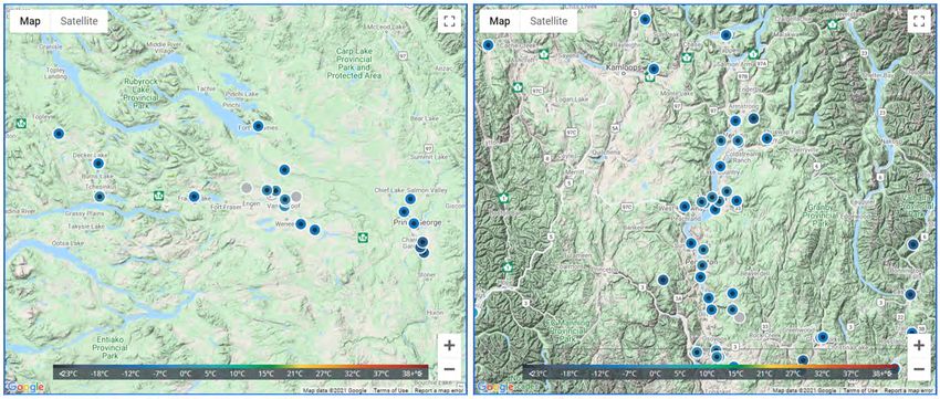
7 A Roadmap for a Sustainable Agricultural Weather Monitoring Network in BCOKANAGAN VALLEY NETWORK Between 2002 and 2004, the Okanagan weather network was established by Growers Supply, a local retailer. Funding was provided through the British Columbia Agriculture Council under the federal-provincial funding program Agriculture Environmental Partnership Initiative (AEPI). The network of 20 weather stations located throughout the Okanagan Valley were established to provide pest management support for the tree fruit industry. During the development of the Okanagan’s Regional Adaptation plan (2015-2016), improving decision support tools was identified as a priority. In 2016-2018, the Sterile Insect Release Program (SIR) partnered with researchers and industry groups to adapt Washington State University’s (WSU) Decision Aid System (DAS) for the BC Okanagan tree fruit industry. DAS is an Integrated Pest Management (IPM) decision support platform that provides critical insect and disease models throughout the growing season. The tool’s development for BC was co-funded by SIR and though CAI’s Regional Adaptation Program. SIR continues to administer the BC DAS throughout the Okanagan-Similkameen. The system relies heavily on the Okanagan weather stations. The stations themselves are manufactured by ADCON Telemetry. These stations are well suited to a network like the Okanagan’s as they are quite robust and mainly communicate through UHF radio. Stations within the network send data wirelessly to a central gateway either directly or by linking through other stations that can act as relays. Cellular options are also available. The Okanagan network faces challenges with its long-term operation and maintenance. Despite replacement of certain components over the years, the stations are old. This raises concerns about their reliability, data accuracy, cost to maintain, and the overall longevity of the network. The ADCON equipment also costs two to four times more than some of the viable alternatives that are now available. The renewal of this network needs to be addressed, including a strategy to modernize the network and ensure that it meets the needs of its stakeholders. Such an assessment will also need to address network operation and ownership, whether this remains with Growers Supply (part of BC Tree Fruits Cooperative) or otherwise. Any such strategy should align closely with the overall provincial goal of improving agricultural weather monitoring for producers. OTHER WEATHER STATIONS When it comes to improving agricultural weather monitoring, one of the most important untapped resources are the weather stations and networks that have been setup by universities, industry organizations, research groups, local governments, cooperatives, processors/distributors, and individual farms. These stations were acquired and established to meet specific requirements for improved weather monitoring - perhaps to cover areas with inadequate representation or to collect parameters that were not available from existing sources. There are many producer-owned monitoring stations across BC’s agricultural areas, including hundreds of Davis Instruments personal weather stations that report data to the Davis WeatherLink portal. According to the Current Weather Conditions maps within the portal, over 20 stations are reporting in the Vanderhoof and Prince George areas and over 30 stations are reporting within the Okanagan-Similkameen (Figure 7). 8 A Roadmap for a Sustainable Agricultural Weather Monitoring Network in BC
You can also read