ACCESS TO RESEARCH INFRASTRUCTURES
←
→
Page content transcription
If your browser does not render page correctly, please read the page content below
ACCESS TO RESEARCH INFRASTRUCTURES

Natural Impact of passive and active volcanic CO2 degassing activity on the atmosphere;
                                                        NICO
  PI: Marco Liuzzo; Co-authors: Andrea Luca Rizzo; Andrea Di Muro; Patrice Boissier;
       Philippe Kowalski; Guillaume Boudoire; Pierre Tulet; Jean-Marc Metzger

  -      Introduction and motivation
  The primary aim of NICO project is the determination of the origin of volcanic gases and their
  incidence and modification in the atmosphere at Piton de la Fournaise (PdF) volcano (Reunion
  island), one of the most active volcanos in the world and an important source of gas released into
  the atmosphere, especially during eruption activity. The ENVRIplus TNA protocol facilitated an
  important opportunity for close collaboration and sharing of ideas and expertise between members
  of the Observatoire Volcanologique du Piton de la Fournaise (OVPF), the Maïdo Observatory and
  to the Instituto Nazionale di Geofisica e Volcanologia (Italy). The period of the fieldwork was
  carried out during the 1st and the 15th September 2017, when it was possible to visit the Maïdo
  Observatory and the OVPF Observatory. The period of the visit and the relative fieldwork started
  after the last eruption at the Piton de la Fournaise (14 July - 28 August), and the surveys, therefore,
  were conducted in period of volcano quiescence.

  -      Multidisciplinary approach
  To achieve the objectives of the project, we planned to carry out field surveys to locate the most
  important emission areas and collect gas for laboratory measurements to define the origin of fluids
  and their evolution over distances. The obtained data, (currently in the phase of analysis and
  modelling) is to be integrated with geochemical and volcanological observations made in
  collaboration with the Observatoire Volcanologique du Piton de la Fournaise (OVPF) and by further
  atmospheric measurements made in cooperation with the local Maïdo Observatory.

  -      Scientific objectives
      In this project we intended to address the existing gap in knowledge by 1) defining the chemical
      and isotopic characteristics of magmatic fluids (CO2, SO2 and noble gases) either at source or in
      distal areas; 2) quantifying the amount of volatiles emitted from the volcano and their evolution in
      the atmosphere; 3) evaluating the impact of volcanic emissions in the local atmosphere.

  -      Methodology and experimental set-up
      The survey on Piton de la Fournaise started shortly after the last eruption (Jul-Aug 2017), therefore,
      a first attempt on the field was to try to collect gas samples from the vent of the recent eruption
      (Fig. 1). Unfortunately this attempt was unsuccessful, owing to the fact that the vent and the
      eruptive fissure was in an advanced state of cooling, releasing only water vapour. We decided, then,
      to work on two different fronts: 1) carrying out a soil CO2 survey in the area of Cilaos, identified
      as an area potentially highly degassing soil CO2 emissions, and sampling the free gas from the
      hydrothermal spring water in the same place in order to identify the isotopic signature of the gas
      released from the aquifer 2) focusing on the data collected from Maïdo and OVPF observatory
      related to the recently finished eruption (July - August 2017).

 ENVRIplus (www.envriplus.eu) is supported by the European Commission under the Horizon 2020 – Research and Innovation
                 Framework Programme, H2020-INFRAIA-2014-2015, Grant Agreement number: 654182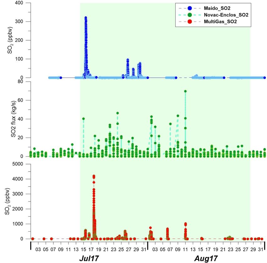
ACCESS TO RESEARCH INFRASTRUCTURES
A
MG
Maïdo Vent (Jul-Aug 2017)
Observatory
Cilaos
Piton de la
Fournaise
B
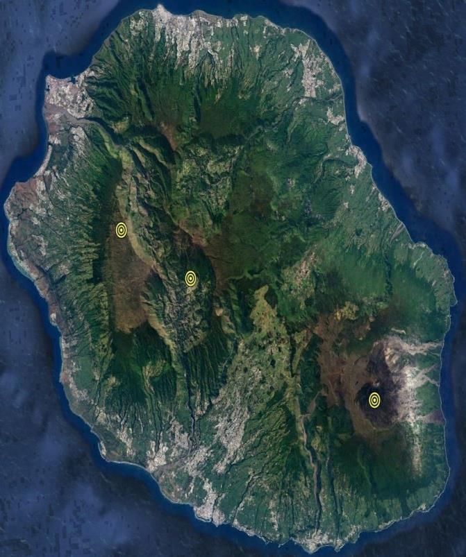
Fig. 1 : Map of La Reunion Island showing the location where measurements of gas were taken during the
TNA visit at La Reunion. A (figure from Tulet et al. 2017 modified) shows the position of the last eruption
(yellow point), the geometry of the NOVAC network of OVPF (stars symbols), and the position of the
MultiGAS (MG) at the summit of the volcano. B shows the map of the soil CO2 survey in the area of Cilaos
(red points) and the site of the hydrothermal water springs at the Cilaos where free gases were taken for
isotopic measurements (square in yellow).
- Preliminary results and conclusions
In order to explore the impact on the atmosphere by the gas emission from the volcanic activity of
the recent eruption at Piton de la Fournaise we combined data collected in a multidisciplinary
approach from a network of instruments (Fig. 1) located either close to the source of emission
(MultiGAS) or in distal areas NOVAC-Enclose and Maïdo Observatory. Fig. 2 shows the time series
of the SO2 flux and SO2 molar concentration measured in the atmosphere during the last eruption.
Here it is possible to observe that a significant increase in the concentration of SO2 was recorded at
Maïdo Observatory after the start of eruption, which was also recorded well by both the near
NOVAC station of Enclos and the MultiGAS station site on the summit of the volcano.
ENVRIplus (www.envriplus.eu) is supported by the European Commission under the Horizon 2020 – Research and Innovation
Framework Programme, H2020-INFRAIA-2014-2015, Grant Agreement number: 654182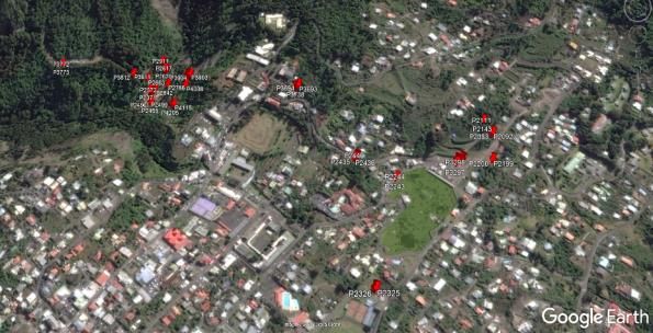
ACCESS TO RESEARCH INFRASTRUCTURES

                              c

                              b

                              a

    Fig. 2 : Time series of the SO2 concentration measured from proximal to distal area on Piton de la Fournaise
    (bottom to top) during the 14 July 28 August eruption (green shadow). The lowest figure a) indicates:
    molar concentration of SO2 measured with the permanent MultiGAS at Piton de la Fournaise by the OVPF
    (in red); while b) above indicates SO2 flux (in green) measured by the NOVAC Enclos station of the OVPF
    network; c) at the top SO2 molar concentration measured at the Maido Observatory (in blue).

Fig 3 shows the variation of isotopic data collected in the hydrothermal area of Cilaos. In this figure
both helium and carbon isotopic signatures show a substantial variation before and after the eruption,
consistent with the geochemical model which predicts isotopic variation during volcanic activity.

   ENVRIplus (www.envriplus.eu) is supported by the European Commission under the Horizon 2020 – Research and Innovation
                   Framework Programme, H2020-INFRAIA-2014-2015, Grant Agreement number: 654182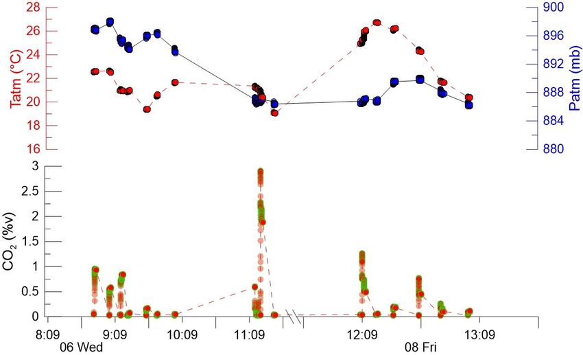
ACCESS TO RESEARCH INFRASTRUCTURES
Fig. 3 : Noble gas and carbon isotopic signature from three different water springs at Cilaos hydrothermal
area. Full symbols are plotted on the right axis (13C); empty symbols are plotted on the left axis (Rc/Ra).
Regarding 13C, samples were taken in three different amounts for each site and all the data are reported.
Fig 4 shows data from the soil CO2 survey conducted at Cilaos. Consistent with isotopic data, the soil
CO2 emissions recorded in Cilaos also show that this is an important degassing area. This is a
preliminary confirmation that Cilaos is an area of La Reunion that holds much potential for the recording
of geochemistry variations (eg: in isotopic as well in flux and concentration rate) which may correlate
with volcanic activity.
Fig. 4 : Soil CO2 molar concentration, pressure and temperature, results from the survey at Cilaos (map in
fig 1 B). The preliminary findings show that the Cilaos has a significant rate of CO2 soil emission not affected
by meteorological parameters.
ENVRIplus (www.envriplus.eu) is supported by the European Commission under the Horizon 2020 – Research and Innovation
Framework Programme, H2020-INFRAIA-2014-2015, Grant Agreement number: 654182
ACCESS TO RESEARCH INFRASTRUCTURES
This preliminary data is in need of further and more careful interpretation. However, our data already
clearly show that the impact from the last eruption on the atmosphere extends well beyond the
immediate vicinity of the Piton de la Fournaise. Most noteworthy is that the connection between
volcanic activity and its atmospheric impact can be tracked from an input originating from the
deepest part of the volcano plumbing system to the dispersion into the atmosphere of one of the
main pollutants (SO2) released from the vent of the volcano in eruption. CO2 emissions, however,
were unfortunately not detected in concentrations above the atmospheric background at distal areas
during the eruption period. Therefore, on this front, further investigations are needed in order to
include within the existing framework the impact of carbon dioxide in the atmosphere from volcanic
eruption at Piton de la Fournaise.
- Outcome and future studies
Outcomes from the present campaign of study include:
Soil CO2 flux measurements
SO2 flux time series during the eruption period (14 July – 28 August 2017)
Time series of SO2 molar concentration in plume from proximal to distal area from the eruptive
vent
13C isotopic signature of free gases from hydrothermal spring waters
Helium isotopic ratio and concentration from free gases of hydrothermal
spring waters
Future studies will focus on the integration of the data collected and in the definition of an
interpretative model for the volcanic gas emitted in the atmosphere during the last eruption of the
Piton de la Fournaise volcano.
- References
Short list of references that are related to the topics and/or methods in this project:
- Boudoire G., M. Liuzzo, A. Di Muro, V. Ferrazzini, L. Michon, F. Grassa, A. Derrien, N. Villeneuve, A. Bourdeu, C. Brunet,
G. Giudice, S. Gurrieri. Investigating the deepest part of a volcano plumbing system: evidence for an active magma path
below the western flank of Piton de la Fournaise (La Réunion Island) - Journal of Volcanology and Geothermal Research
dx.doi.org/10.1016/j.jvolgeores.2017.05.026
- Di Muro, A., Métrich, N., Allard, P., Aiuppa, A., Burton, M., Galle, B., and Staudacher, T.: Magma degassing at Piton de
la Fournaise volcano, Active Volcanoes of the World series, Springer, edited by: Bachelery, P., Lenat, J. F, Di Muro, A.,
and Michon, L., 2016b
- Liuzzo, M., A. Di Muro, G. Giudice, L. Michon, V. Ferrazzini, and S. Guerrieri (2015), New evidence of CO2 soil degassing
anomalies on Piton de la Fournaise volcano and the link with volcano tectonic structures, Geochem. Geophys. Geosyst.,
16, 4388–4404, doi:10.1002/2015GC006032.
- Rizzo A.L., M. Liuzzo, M.A. Ancellin, H.J. Jost Real-
volcanic plume gases at Mount Etna, Italy, over 5 consecutive days (2015) Chemical Geology 411 182–191
http://dx.doi.org/10.1016/j.chemgeo.2015.07.007.
- Tulet, P., Di Muro A., Colomb A., Denjean C., Duflot V., Arellano S., Foucart B.1,, Sellegri K., Peltier A., Aiuppa A., Sciare,
J., Barthe C., Bhugwant C., Bielli S., Boissier, P. , Boudoire G., Bourriane T., Brioude J., Brunet, C., Cammas J.P., Duriez E.,
Gabarrot F., Galle, B., Giudice G., Jeamblu F., Kowalski, Ph., Leclair de Bellevue J., Marquestaut N., Mékies D., Metzger
J.M., Villeneuve N. (2017) First results of the Piton de la Fournaise STRAP 2015 experiment: multidisciplinary tracking of
a volcanic gas and aerosol plume. Atmos. Chem. Phys., 17, 5355–5378, 2017. doi:10.5194/acp-17-5355-2017
P.I. NICO project
Marco Liuzzo
ENVRIplus (www.envriplus.eu) is supported by the European Commission under the Horizon 2020 – Research and Innovation
Framework Programme, H2020-INFRAIA-2014-2015, Grant Agreement number: 654182You can also read


