Adopted Version Alvington Parish Neighbourhood Development Plan 2016 2026 - Forest of Dean District Council
←
→
Page content transcription
If your browser does not render page correctly, please read the page content below
Alvington Parish Neighbourhood Development Plan
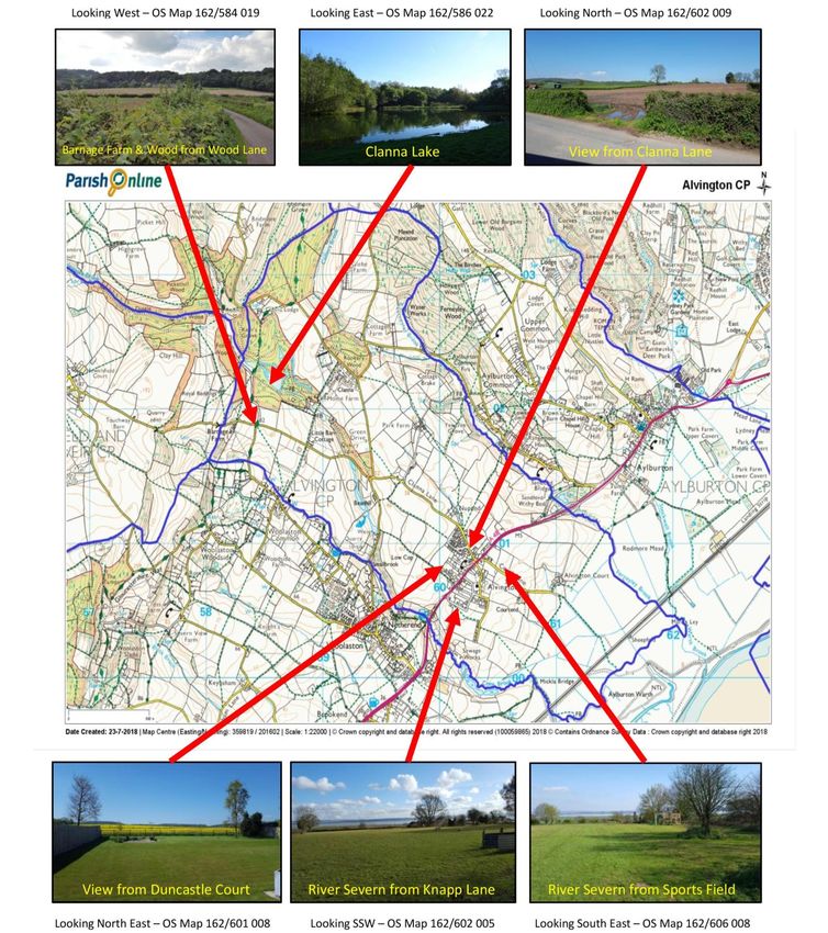
2016 - 2026
Adopted Version
6th May 2021
Page 1 of 48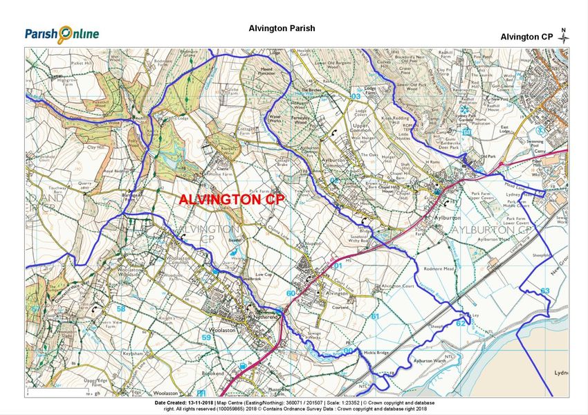
Prepared by the Neighbourhood Development Plan Steering Group on behalf of Alvington
Parish Council, and with the assistance of Kirkwells.

                                        Page 2 of 48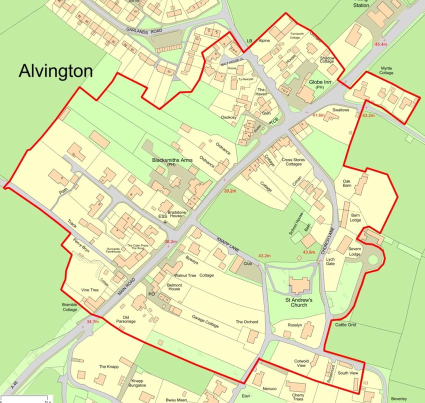
Contents
          Cover                 ..................................................................................................................................... 1
1.0       What is a Neighbourhood Development Plan (NDP)? ............................................................................. 4
2.0       Neighbourhood Area Designation........................................................................................................... 5
3.0       Vision Statement and Objectives ............................................................................................................ 9
4.0       Policy C1 and C2 - Community Infrastructure ....................................................................................... 11
5.0       Policy F1 - Reducing Flood Risk .......................................................................................................... 15
6.0       Policy NE1, NE2 and NE3 - Natural Environment ................................................................................. 19
7.0       Policy BE1 and BE2 - Built Environment............................................................................................... 30
8.0       Policy HM1 - Housing Mix .................................................................................................................... 37
9.0       Policy E1, E2 and E3 - Economy, Business and Tourism……………………………………………..……. 39
10.0      Clanna Country Park............................................................................................................................ 41
11.0      Pre submission, Submission and Referendum of the NDP.................................................................... 42
12.0      Monitoring and Reviewing .................................................................................................................... 43
13.0      Projects              ................................................................................................................................... 44
14.0      Abbreviations/Glossary of terms used .................................................................................................. 45
15.0      References            ................................................................................................................................... 46
16.0      Acknowledgements .............................................................................................................................. 47

17.0   Appendices
          Appendix 1           Consultation Statement ~ (16 pages)
          Appendix 2           Basic Conditions Statement ~ (10 pages)
          Appendix 3           Alvington NDP business survey analysis summary ~ (2 pages)
          Appendix 4           Alvington Character Assessment incorporating Updated Character Appraisal.~ (32 pages)
          Appendix 5           Alvington - businesses (abridged version) ‘Digital Deprivation’ ~ (4 pages)
          Appendix 6           Listed Buildings in Alvington Parish including photos ~ (10 pages)
          Appendix 7           Intentionally Blank
          Appendix 8           A48 Main Road ~ (56 pages)
          Appendix 9           Flooding and Sewage ~ (54 pages)
          Appendix 10          Amey Drainage Report, 2016 ~ (20 pages)
          Appendix 11          Infrastructure ~ (144 pages)
          Appendix 12          Planning applications and consents ~ (84 pages)
          Appendix 13          Alvington history and archaeology + The History of Alvington ~ (186 pages)
          Appendix 14          Transport ~ (68 pages)
          Appendix 15          Alvington NDP Priorities ~ (5 pages)
          Appendix 16          Species recorded in the Parish (update from GCER) ~ (34 pages)
          Appendix 17          Alvington - Planning Policy Assessment and Evidence Base Review (PPA) ~ (72 pages)
          Appendix 18          Alvington - OCSI Alvington-CP November 2016 ~ (54 pages)
          Appendix 19          Footpath/Pavements Open Day Feedback - including Footpath Maps ~ (8 pages)
          Appendix 20          Project – Pavilion and Fund Raising ~ (10 pages)
          Appendix 21          Gloucestershire Wildlife Trust – Maps ~ (4 pages)
          Appendix 22          HRA (Habitat Regulations Assessment) report ~ (38 pages)
          Appendix 23          SEA (Strategic Environmental Assessment) report ~ (20 pages)
          Appendix 24          Statutory Consultation Regulation 14 Documents ~ (86 pages)
                                                                       Page 3 of 48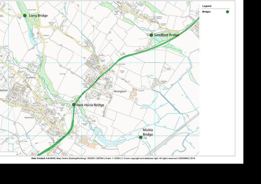
1.0 What is a Neighbourhood Development Plan (NDP)?
                                                                                       Figure 1 NDP Process

1.1      The Localism Act empowers a parish or town council to produce a development plan for the
         area, known as a Neighbourhood Development Plan (NDP). NDPs are intended to guide
         development, reflecting the views of local people on a range of planning matters (e.g. numbers
         of houses built or where employment is sited) which will affect how their parish or town
         develops.
1.2      NDPs must have regard to national planning policy such as the National Planning Policy
         Framework (NPPF) 20191 and other guidance including National Planning Practice Guidance
         (NPPG)2. The NDP must comply with European regulations (including those concerning
         environmental matters). See also the Planning Policy Assessment (PPA) (Appendix 17).
1.3      NDPs are drawn up by a working group of the parish or town council and are based on the
         views of local people. If passed by an independent examiner and a local referendum, the NDP
         will become a legal document and incorporated into the local planning authority’s statutory
         planning framework.

1
    https://www.gov.uk/government/publications/national-planning-policy-framework--2
2
    https://www.gov.uk/government/collections/planning-practice-guidance
                                                    Page 4 of 48
2.0 Neighbourhood Area Designation

2.1      Alvington Parish Council applied to the Forest of Dean District Council (FoDDC) on 27th
         January 2016 for the parish of Alvington to be designated as a Neighbourhood Area, for the
         purpose of preparing an NDP. The area was designated by the FoDDC on 12th May 2016.
         The designated Neighbourhood Area is shown in Map 1 and matches exactly the existing
         boundary of the parish.

                                                                        Map 1 Alvington Parish and NDP Area

                                                                                    Legend

                                                                                    Parish/Neighbourhood
                                                                                    Area Boundary

2.2      Preparing a NDP is a complex and lengthy process. The main steps are set out in Figure 1, on
         page 4.

Strategic Context
2.3      The planned life of the Alvington NDP will be up to 2026. This aligns with the FoDDC adopted
         Core Strategy, as referenced in the Allocations Plan policy AP 81 on pages 154–156.3
2.4      Alvington NDP has been underpinned by a clear and robust evidence base of local opinion
         and technical resources. It addresses local planning issues identified through extensive
         community consultation and engagement (Consultation Statement, Appendix 1) and sets out
         a total of 12 planning policies to address them.

3
    https://www.fdean.gov.uk/residents/planning-building/planning-policy/local-plan-new/allocations-plan/
                                                      Page 5 of 48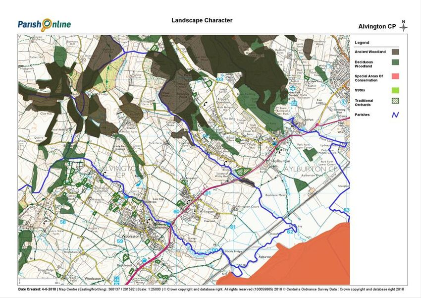
2.5      NDPs must be in general conformity with local strategic planning policies. The strategic
         planning policies are set out in the Core Strategy Plan4 and Allocations Plan, which was
         published on 28th June 2018.5 The Allocations Plan includes a number of district wide policies
         and a policy map for the settlement of Alvington which includes a tightly drawn settlement
         boundary, a site allocation for 11 dwellings at Clanna Road, the conservation area, recreation
         space and several important open spaces.
                                                                           Map 2 Alvington Allocations Plan Policies

                         Legend
                         Settlement Area
                         Important open spaces - Green Shaded areas
                         Housing Allocations - Red Shaded
                         Conservation Area Boundary - Red Dotted

A Portrait of Alvington Parish
2.6        The parish of Alvington is located in the Forest of Dean, on the northern banks of the River
           Severn, about 2 miles southwest of Lydney and 6 miles northeast of Chepstow. The village
           of Alvington is the main settlement in the parish and there are also several smaller scattered
           settlements to the north of the village such as Clanna Country Park (a residential area), and
           farms such as Beanhill, Cottage, Glebe, Home, Nuppend, Park and Pipers Meadow. The
           parish is very rural in character; it extends across about 660 hectares and has a very low

4
    http://www.fdean.gov.uk/residents/planning-building/planning-policy/local-plan-new/core-strategy/
5
    https://www.fdean.gov.uk/residents/planning-building/planning-policy/local-plan-new/allocations-plan/
                                                            Page 6 of 48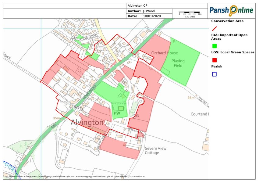
population density (0.8 persons per hectare). The village is bisected northeast to southwest
          by the busy A48.
2.7       In 2011 (see 2011 Census6) the parish had a population of 506 residents living in 237
          households. Of these, about 380 residents lived in the village. FoDDC Electoral Services
          advised that as of 1st December 2018 there were 504 electors living in 295 properties.
2.8       A selection of local buildings of character and heritage:

                       The Globe Inn                                  Cross Stores Cottages

                        Globe Cottages                                 Farnsworth Cottage

                        The Blacksmiths Arms                          Ordinance House

2.9       The village has largely developed along the A48 and there remain some older terraced
          properties and some significant older buildings such as the Globe Inn. To the west of the A48
          is the more recent Garlands Road housing estate.
2.10      The village has 2 public houses (The Globe Inn and The Blacksmiths Arms), a church (St
          Andrew’s) and the Memorial Hall. (Map 3, page 11) There is also petrol station with a shop.
          Local primary schools are in Woolaston and Aylburton over a mile in either direction along
          the main A48 road. Transport (Appendix 14) and bus services are very limited to both schools,
          and parents rely on private cars to transport children every day. There are 2 local secondary

6
    https://www.nomisweb.co.uk/reports/localarea?compare=1170214159
                                                 Page 7 of 48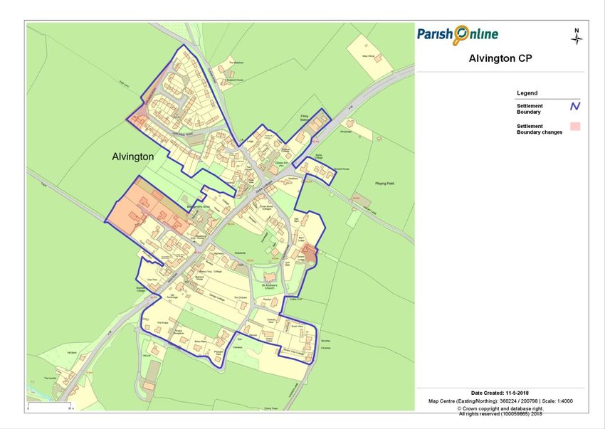
schools: Dean Academy in Lydney, and Wyedean in Sedbury, near Chepstow. A school bus
       runs to Wyedean but not the Dean Academy.
2.11   Development to the east of the main road has a more open character, with buildings in larger
       plots, including some recent bungalows and houses along Church Road, a narrow country
       lane. The open agricultural land near the church breaks up the form and affords views of the
       church. The majority of the settlement lies within a conservation area.
2.12   The village and conservation area have a distinctive local character, and the NDP will have
       a key role in helping to ensure future development is sympathetic to the existing materials
       and form. Traditional building materials include brick, forest red sandstone and render with
       slate and grey tiles, and a more uniform character on modern estates.

                      Garlands Road                                  Garlands Road

       The NDP Process So Far
       Alvington Character Appraisal
2.13   A significant part of the evidence base for the Plan is the Alvington Character Appraisal. The
       initial appraisal was subject to consultation through a public exhibition in October 2016. The
       subsequent comments made by residents were considered, and incorporated where
       appropriate, for the second version.
       See the ‘Alvington Character Assessment Incorporating Updated Character Appraisal
       January 2020’ (Appendix 4).
2.14   As a result of this first consultation and questionnaire, key NDP priorities were identified
       (Appendix 15).

                                             Page 8 of 48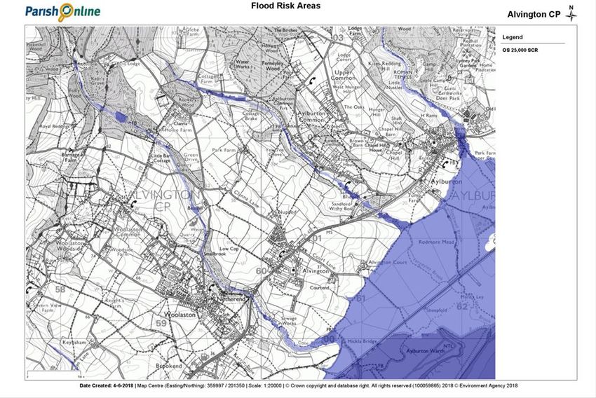
3.0    Vision Statement and Objectives

                                          VISION

      Alvington is a safe place which looks to the future, where people
      have the opportunity to live and work using the latest technology
      and enjoy the peace and tranquillity of the countryside.

      NDP Objectives

      Objective 1 - Community Infrastructure
      To protect and enhance local community infrastructure and
      facilities.

      Objective 2 - Flood Risk
      To guide new development to areas at lowest risk of flooding and,
      where appropriate, to ensure sustainable mitigation measures are
      provided to reduce flood risk from new development.

      Objective 3 - Natural Environment
      To protect and enhance the natural environment in the parish, with
      new development respecting local wildlife and landscape character.

      Objective 4 - Built Environment
      To protect the built environment from inappropriate development
      within and outside the conservation area, and to encourage new
      development to be designed sensitively to the local character.

      Objective 5 - Housing Mix
      To support provision of a mix of housing including affordable
      housing.

      Objective 6 - Economy, Business and Tourism
      To support the local economy, businesses and tourism.

3.1   The NDP steering group has prepared the Vision and Objectives for the NDP in consultation
      with the community. (Appendix 1)

                                          Page 9 of 48
3.2   A further objective which came out of the community consultations and which is highly
      significant to local residents is the need to address road safety on the A48 and the impacts
      and volume of traffic (Appendix 8). However, these are not land use planning matters but
      transport issues which should be addressed by the local transport authority (Gloucestershire
      County Council), possibly through the Local Transport Plan (LTP). The NDP steering group
      has worked hard to provide evidence to support proposals for improving traffic and road
      safety and these have been defined and listed (Appendix 15) for possible future action by the
      appropriate body.
3.3   Planning policies have been prepared to address the NDP objectives and are set out in the
      order of the objectives in Sections 4 to 9 of this plan.

                                           Page 10 of 48
4.0 Policies C1 and C2 - Community Infrastructure
Policy C1: Local Community, Retail, Commercial Facilities and
Services
Changes of use of the church, Memorial Hall, petrol station / shop and 2
public houses (as shown on Map 3) to other non-community uses, will not
be supported unless it can be demonstrated that the existing use is no
longer economically viable or equivalent or better provision of the facility to
be lost is made in an equally or more accessible location.
Where a development proposal contends that the existing use of one of the
community, retail and commercial premises shown on Map 3 is no longer
economically viable, evidence should be provided to show that the site has
been actively marketed at the market rate for at least 12 months and that no
sale or let has been achieved during that period.
Map 3 Village Facilities
4.1 Local community facilities are highly valued by residents in Alvington (Appendix 11). Local
facilities include the following:
Page 11 of 48St Andrew’s Church
4.2 This is used for church services, weddings, christenings, funeral services and by bell
ringers.
St Andrew’s Church
The Memorial Hall
4.3 This is used for band practice, line dancing, puppy school, private parties, parish council
meetings, bouncy castle sessions, sequence dancing, weddings, children’s parties, football
meetings, funeral wakes, elections, dog training workshops, Zumba, NDP meetings and belly
dancing, as well as the hall’s toilets being made available for church users.
Alvington Memorial Hall
4.4 There are also several local businesses which provide a valuable local service to residents
of Alvington. These are the petrol filling station, shop and car wash and the 2 public houses,
the Globe Inn and the Blacksmiths Arms.
4.5 Feedback from consultations noted the friendly community and suggested that improvements
were needed in the provision of community facilities (Appendix 1 Consultation Statement).
4.6 The Core Strategy’s CSP.8 policy entitled ‘Retention of community facilities’ sets out that
development proposals involving the loss of community facilities will not be permitted unless
alternative suitable and convenient facilities are available or will be made available.
Page 12 of 48Policy C2: New Community and Recreation Facilities
Development proposals for new or expanded community and recreation
facilities will be supported subject to the following criteria:
1. Their sighting, scale and design respects the character of the
surrounding area, including any historic and natural assets; and
2. They are accessible to the local community.
3. They take account of the location of residential properties in the
immediate local area and do not have an unacceptable impact on their
amenity; and
4. They prove appropriate levels of car parking; and
5. They can be satisfactorily accommodated into the capacity of the local
highway network.
Proposals for the development of a pavilion building at the Sports Field will
be particularly supported.
Sports Field and Play Area
Sports Field
Sports Field - Play Area
Page 13 of 484.7 There is approximately 1.683 ha (4.16 acres) of land off Court Lane which the parish council
manages for recreational purposes. The land was specifically given under Deed of Gift in
1953 ‘for the purpose of a Sports Field or Recreation Ground’, and the deed specifically
forbids the erection of any building other than a sports pavilion.
4.8 It is the wish of the villagers to see improvements in local provision. There is no sports
pavilion, but extensive discussion has taken place recently, and a planning application has
been submitted by the parish council, pending decision as of October 2019.
Pavilion - Sports Field Feedback
4.9 The Sports Field Committee attended the Village Development Plan open day on 23/10/16
to seek guidance on the future development of the Alvington Sports Field in order to benefit
the village. This was well attended and gave many of the villagers, of all ages, the opportunity
to express their opinions on how the Sports Field could be developed. In order to gather as
much information as possible a questionnaire was available for all to complete.
4.10 The information from this was then correlated in order to gain an overview of opinions, of
which many were duplicated, and the numbers of the same proposal were then identified
presenting a common opinion (Appendix 20)
4.11 There were 20 responses as well as many verbal comments, which were recorded also.
Location
4.12 The sighting of a pavilion must provide easy access for all users – including those with
mobility needs, health issues, and disabilities, including wheelchair users – as well as taking
advantage of the views over countryside to the River Severn and the Cotswolds beyond. It
has been agreed that the pavilion will be sited adjacent to the car park.
4.13 The development should be designed to maximise the retention of surface water on the
development site and to minimise run-off. Sustainable drainage systems (SuDS) should be
implemented in accordance with the SuDS hierarchy wherever possible.
4.14 The public open spaces in and around Alvington village have significant potential to assist
with the attenuation of surface water flows, whilst contributing to the amenity and biodiversity
value of the area.
Page 14 of 485.0 Policy F1 - Reducing Flood Risk
Policy F1: Reducing Surface Foul/Water Flooding
As appropriate to their scale and location, proposals for new residential
development should include any necessary improvements to the existing
sewerage system and protect against surface water flooding in general, and
in high risk areas in particular including Clanna Lane and Swan Hill.
Development in the clearly defined high-risk areas (Map 5 page 18) will not
be supported until infrastructure can be demonstrated to support it.
Anti-flooding designs should protect the proposed development site itself
and also ensure that there is no unacceptable increase in downstream risks
particularly those areas that are known flood risks identified in the Revised
Amey Drainage Report, 2016 (Appendix 10).
New development should be designed to maximise the retention of surface
water on the development site and to minimise run-off. Sustainable drainage
systems (SuDS) should be implemented in accordance with the SuDS
hierarchy.
Developers should follow the Drainage Hierarchy (Planning Practice
Guidance Paragraph 80), disposing of surface water sustainably through
SuDS if infiltration rates are satisfactory, or through connection to the
culverted watercourse running along the boundary of the site.
Development proposals should incorporate practical and effective
management regimes, for the maintenance of any anti-flooding solutions
and to ensure that they continue to operate effectively and efficiently.
Clanna Lane (Road) Looking SE in the Direction of the A48 Main Road, January 2016
Page 15 of 485.1 Flooding is a significant concern for residents of Alvington and this was evidenced in the early
community consultations for the NDP. During the first consultation, comments expressed that
flooding has worsened over the last 20 years and that new building should not take place on
flood plains. Specific issues around Swan Hill and Clanna were also noted.
5.2 There are 2 main areas in Alvington where flooding is known to be a recurrent problem:
1. Clanna Lane, continuing onto the A48 Main Road.
2. A48 at Swan Hill, including sewerage.
5.3 Table 1 Flooding Clanna Lane. Occurrences in 2016.
Day Date Time of Day Duration
Tues/Wed 26th & 27th Jan 2016 Continuous 24 hours
Friday/Saturday 29th & 30th Jan Continuous 9 hours
Saturday 6th February Morning 5 hours
Saturday 6th February Evening 5 hours
Sunday 7th February Evening 4 hours
Wednesday 9th March Overnight until 10 am 4 hours +
Wednesday 11th May Evening 2 hours
Wed to Sunday 11th to 15th May Evening until Afternoon 5 days **
Friday 10th June Evening 2 hours
+ More than 4 hours
** It was noted that 1 of the 4 trenches excavated during the archaeological dig on the 3rd and 4th
May, on the proposed development land off Clanna Lane, was flooded to a depth of approx. 1
metre for 5 days from 11th May due to the high water table in the field. The trenches were refilled
on 20th June 2016.
5.4 Table 2. 2017 Flooding of Clanna Road and A48 Main Road. Note: occurrences only
recorded in latter part of year.
Day Date
Tuesday 26th December 2017
Wednesday 27th December
Friday 29th December
Table 3. 2018 partial recordings, 2019 partial recordings and 2020 Flooding Clanna
Road/A48 main road, occurrences – up to 3rd March 2020.
2018 2019 2020
1st January 25th June * 10th January *
15th January 11th August * 15th January *
9th March 27th September * 8th February
10th March 29th September * 9th February
29th March 4th October * 10th February *
30th March 13th October * 15th February
1st April 18th October * 16th February
2nd April 26th October * 17th February *
3rd April 8th November 22nd February
14th November * 23rd February
28th February
29th February *
* Denotes Sewage overflow Main Road and “Tudor Cottages” bottom of Swan Hill (A48)
Page 16 of 485.5 Map 4 shows risk of fluvial flooding areas in Alvington.
Map 4 Fluvial flooding risks in Alvington7
5.6 Extensive maintenance work has recently been carried out on the sewerage system by
Severn Trent Water. This has improved the sewage flooding problem at Swan Hill but has
not resolved the issue completely as the sewerage system has reached its capacity and
surface water is adding to the problem.
5.7 Surface water is a highways authority (Gloucestershire County Council) matter, and recurrent
flooding events have led to 2 Amey flooding reports, one for the Clanna Lane area and one
for Swan Hill.8 The recommendations to address the problems at Swan Hill are set out in
Sections 3 and 4 of the Amey report – (Appendix 10). There are 4 possible ways to resolve
the Clanna Lane problem, as set out on pages 7, 8, 9 and 10 of the Amey report. A number
of repairs were made to the drains in spring 2017 but not completed due to cost restraints
and complications with underground electric cables being above the ducts, according to the
engineers on site. The possible improvement works are all very expensive, and unlikely to be
carried out in the near future, according to advice provided at the time by Amey, working on
behalf of Gloucestershire County Council’s Highways department.
5.8 The Amey recommendation for repair at 1 Tudor Cottage, Swan Hill, Alvington was carried
out during March / April 2017. However, there are still problems with sewerage waste in the
garden, with 6 incidents reported between June 2019 and October 2019 following heavy (but
not torrential) rain.
7
https://flood-warning-information.service.gov.uk/long-term-flood-risk/map
8
https://alvingtonvillage.org/wp-content/uploads/2018/01/Alvington-NDP-REVISED_AMEY_DRAINAGE_REPORT-25th-
Feb-2016.pdf
Page 17 of 485.9 Some repair work was undertaken in March 2017 to drainage pipes in Clanna Lane. This has
reduced flooding in the Clanna Lane area, but it is still an issue, for instance, Highways were
called out on the 18th October 2019 following heavy flooding.
Junction of A48 Main Road and Clanna Lane/Road by Globe Inn - November 2014
5.10 It is essential that any future development in Alvington does not cause or exacerbate flooding
elsewhere in the locality. The NPPF 2019 sets out that development should be directed away
from areas at highest risk of flooding, and where development is necessary it should be made
safe without increasing flood risk elsewhere (NPPF, para 163, page 48). Core Strategy Policy
CSP.2 entitled Climate Change Adaptation sets out how development should manage
surface water run-off and how measures should be taken to improve resistance, resilience
and safety of the areas concerned. Allocations Plan Policy AP 1 Sustainable Development
sets out that the primary consideration in assessing planning applications will be whether the
proposal is sustainable, and this includes supporting development where the locations and
designs are more resilient to the effects of a changing climate.
5.11 Map 5 Surface Flooding and Sewage Outflow
Page 18 of 486.0 Policy NE1, NE2 and NE3 - Natural Environment
Policy NE1: Protecting and Enhancing Local Wildlife
Development proposals that affect local wildlife sites and habitats identified
on Map 6, page 22 should demonstrate how adverse impacts on biodiversity
will be avoided, or if that is not possible adequately mitigated. All
developments should protect wildlife, and all but the most minor are
expected to deliver a net gain for biodiversity.
Landscaping schemes should include wildlife enhancements wherever
practicable, for example incorporating ponds, and retaining existing and
planting new areas of woodland and hedgerows using locally appropriate
native species.
Development should take into consideration the need to protect existing
wildlife which may be using the building(s) as habitats, such as owls, swifts
and bats which are known to nest and roost locally. Buildings should
incorporate bird nest boxes and roosting opportunities for bats wherever
practicable.
Lighting schemes should be designed sensitively to reduce any adverse
impacts on wildlife and to protect the dark skies which are characteristic of
this rural area.
6.1 To protect and enhance important flora and fauna and their natural habitats.
Public authorities have a duty under Section 40 of the Natural Environment and Rural
Communities Act 2006 to have regard to conserving biodiversity as part of policy or decision-
making. Alvington benefits from a wide range of natural habitats and wildlife, many of which
feature in the national priority habitat and priority species lists. The natural setting of the
parish results from traditional farming and forestry suited to the area and adds greatly to the
character of the parish and the quality of life of residents. Neighbourhood planning policy
needs, therefore, to take biodiversity into account both for its own sake and in the interests
of local distinctiveness and preserving the character of the area.
The need for neighbourhoods to take biodiversity into account is reflected in the Forest of
Dean District Core Strategy Policy CSP.1 – Design and environmental protection.
6.2 Alvington parish has a distinctive rural character with many natural heritage assets. It is
evident from early public consultations that residents value the quiet, peaceful and rural
character of the local countryside.
Page 19 of 48Wildlife
6.3 Natural heritage assets in the parish include several areas of ancient and semi-natural
woodland and ancient replanted woodland in the north of the parish which are of value to
wildlife. These end abruptly where the parish meets the flat plain of the River Severn,
characterised by traditional grazing marsh and grassland. Other locally distinctive features
include Cone Brook and the series of lakes which lie along its tributary through Clanna Wood,
which is also notable for complex braided streams, waterfalls and marshland of a type
characteristic of the slopes leading down from the main Forest of Dean woodland plateau.
6.4 Wildlife interest in the Parish (Appendix 16 and Appendix 21)
The map in Appendix 21 shows the wildlife sites and habitats that are important to the parish
and to the area that immediately surrounds it. 233 hectares of semi-improved or unimproved
habitats were identified by Gloucestershire Centre for Environmental Records, 220 ha of
which lie within the parish boundary (the rest is part of sites which overlap into adjacent
parishes). This represents 33% of the 660 ha parish, accounting for the distinctively wooded,
natural-looking setting, which grades into traditional grazing pasture alongside the River
Severn. Of the 220 ha of habitat within the parish boundary, nearly three quarters (162 ha) is
priority habitat such as deciduous woodland, traditional orchard and floodplain grazing
marsh.
It should be noted that other habitats such as farmland and gardens are also important for
wildlife, both in their own right and as habitat corridors and linking territories for species in
more diverse habitats. Thus, a rare bird of prey may be sighted nesting in the ancient
woodland priority habitat but hunting over adjacent farmland. Similarly, gardens can provide
valuable winter food and shelter for songbirds which retreat to more secluded and species-
rich habitats to breed and raise young in summer.
The species list in Appendix 16 lists the 563 species which have been recorded in Alvington
parish since 1980; of these, 222 have one or more designations, due either to their rarity,
vulnerability or rate of decline. Notable sightings include birds of prey such as goshawk and
Kestrel, wading birds including curlew, redshank and lapwing, dragonflies and damselflies, 9
species of bat, otter, brown hare and a long list of wild flowers including bluebell, common
spotted-orchid, ragged robin and a wide range of native trees.
HRA (Habitat Regulations Assessment) (Appendix 22).
SEA (Strategic Environmental Assessment) (Appendix 23).
6.5 Just beyond the parish boundary to the south lies the Severn Estuary Site of Special Scientific
Interest (SSSI), which is also a Ramsar site, Special Protection Area (SPA) and Special Area
of Conservation (SAC) (European designations). Whilst not within the parish boundary, the
calculated Impact Risk Zones for the Severn Estuary SSSI extend into Alvington. However,
the Impact Risk Zones only apply in the case of particular types of development, most of
which are unlikely to occur in the parish. Beyond the parish boundary to the northeast lays
an area within Wye Valley and Forest of Dean Bat Sites (SAC) and Devil's Chapel, Scowles
SSSI. Alvington forms part of the Core Sustenance Zone for the Wye Valley and Forest of
Dean Bat Sites, meaning that bats within the protected sites depend partly on habitats within
Alvington for their survival.
6.6 Core Strategy Policy CSP.2 – Climate Change Adaptation: Biodiversity (Part 3). Biodiversity
requires development to support green infrastructure corridors and to make long-lasting
biodiversity enhancements.
Page 20 of 48Biodiversity Protection and Enhancement Policy:
In line with the Forest of Dean District Core Strategy Policies CSP.1 and CSP.2, proposals
for development will be supported where the application in question includes rigorous
measures to:
1) Conserve and enhance the biodiversity of the area, in particular:
• any sites designated for their biodiversity importance
• protected species
• priority species and habitats
• species habitats that are locally characteristic (as detailed in Appendix 16 and Appendix
21 respectively)
and/or
2) Enhance the connectivity between existing biodiversity sites and habitats
and/or
3) Increase the potential for the public to enjoy biodiversity and increase their understanding
of its importance both locally and in a wider context.
6.7 New development in Alvington should enhance the environment for wildlife. Simple measures
can be worked into most development projects to provide features for wildlife to use, and
detailed advice on this can be found in the Forest of Dean's Biodiversity & Planning
applications - Advice for applicants9. Locally relevant principles have been brought forward
into Policy N1 Protecting and Enhancing Local Wildlife.
Landscape Character
Topography
6.8 Alvington is situated in an area classified as the Severn Vale. This is characterised by rolling
landform, often with mature hedgerows lining the worked agricultural landscape. The soil in
the Severn Vale is ideal for the growth of fruit trees, and large areas of orchard were
historically present in Alvington, remnants of which still survive.
Wider Parish Analysis
6.9 Outside of the settlement boundary, with the exception of the Garlands Road development
and Clanna Country Park, the parish consists mostly of farmland (approximately 70%) and
woodland (approximately 20%) with just 10% being residential.
Landmarks
6.10 The following land within the parish boundary is owned and maintained by the Forestry
Commission:
Woodland south of Clanna Lodge (known locally as Clanna Woods although maps reference
Kear’s Grove) including Clanna Ponds and Lakes; Rookery Wood; and Green Drive disused
quarry site.
As such, all are recognised as areas of open access land under the Countryside and Rights
of Way Act, and many of these areas are also recorded on the Ancient Woodland Register,
indicating that they have been woodland since at least 1600. Additionally, these areas are
recognised for their importance for wildlife.
Note that much of the flood plain along the Severn Estuary is not in fact part of Alvington
parish but falls under Aylburton parish.
9
http://www.fdean.gov.uk/residents/planning-building/planning-applications/biodiversity-planning-applications/
Page 21 of 48Map 6 Landscape Character
.
6.11 The Allocations Plan notes that part of Alvington parish is in ‘Landscape Character Type 4
Wooded Scarp and Lower Scarp Slopes: Landscape Character Area 4b (Map 7). Netherend
Farmed Slopes’. The other part of the parish lies in ‘Landscape Character Type 6 Unwooded
Vale: Landscape Character Area 6a (Map 7) Severn Vale - Stroat and Sedbury’. These
landscape designations are identified and described in the Forest of Dean Landscape
Character Assessment 2004 supported by the Forest of Dean District Landscape
Supplementary Planning Document (SPD).10
Map 7 Locations of Landscape Areas in Alvington Parish.
10
http://www.fdean.gov.uk/media/3711/landscape-supplementary-planning-document-march-2007.pdf
Page 22 of 48Policy NE2: Protecting and Enhancing Local Landscape Character
Development proposals should demonstrate how sighting and design have
taken into consideration local landscape character.
Outside the village, the parish’s dispersed settlement pattern should be
maintained, and any new rural buildings should be located on lower scarp
slopes, below the skyline.
Development proposals should respect the wide panoramic views down
towards the Severn Estuary and views and up towards the wooded slopes of
the higher scarp slopes which are locally valued, and which make an
important contribution to the Neighbourhood Area’s landscape character.
These views are shown on Map 9 page 26.
Development proposals should safeguard or incorporate areas of woodland,
small copses and hedgerows within their layouts where it is practicable to do
so.
6.12 The character of Landscape Character Area 4b (Map 7 page 22) Netherend Farmed Slopes
is described as follows:
The distinctive landscape of gentle slopes bordering the steep wooded scarp stretch from
Aylburton Common in the east to Tidenham in the west and fringe the softer undulating vale
landscapes bordering the Severn. Streams draining the plateau and emerging from springs
have dissected the underlying geology to form a series of undulating ridges and valleys
running at parallel to the direction of the general slope. These valleys tend to be steep sided
and as such contain either rough pasture or linear stretches of broadleaved woodland. The
ridges tend to be cloaked in a patchwork of large fields enclosed by well managed
hedgerows.
These fields are generally managed as improved pasture. However, arable fields are
conspicuous in the vicinity of Woolaston where calcareous soils and gentle landform provide
productive farmland.
Linear villages and settlement clusters are most numerous. These tend to be sited alongside
roads running at or close to the crest of ridgelines between the vale and the plateau.
Netherend is the largest settlement and is located above the Cone Brook. Further to the north
an area of smaller fields and dispersed farms at Woolaston Common indicates sporadic
settlement of former common land. Elsewhere isolated farmhouses are conspicuous
throughout the landscape. Despite these often being sheltered by small deciduous copses
they are particularly visible from the scarp slopes to the north due to them being whitewashed.
The shiny roofs of barns are also highly visible when viewed from neighbouring uplands.
Wide panoramic views to the south are possible from the top of the ridges and higher
undulations although in the valleys woodland and landform combine to obscure views and
create more intimate landscapes.
6.13 The character of Landscape Character Area 6a Severn Vale – Stroat and Sedbury is
described as follows:
The southern extent of the Severn Vale in the district extends from Alvington in the east to
the Beachley peninsula in the west. The landscape is typical of the vale and gently undulating
landform is cloaked in a patchwork of productive pastures and arable fields defined by well-
maintained hedges. Saline inundation is evident in pastures adjacent to the lower reaches of
Page 23 of 48the Wye such as at the Pennsylvania Fields SSSI. These areas are notable for nationally
scarce plants. The underlying geology is largely Quaternary gravel terrace deposits & tidal
flat deposits of silty clay lying above Triassic mudstones. Alluvium and alluvial fan deposits
are also evident. The rich red soils appear to be well suited to dairy farming which is
particularly conspicuous in the area.
Cattle sheds are typically large modern constructions surrounded by a concrete yard. These
often gain visual prominence in an otherwise relatively flat landscape. Their size may be an
indication of the intensive nature of dairy farming locally. Arable farming is also conspicuous.
An outcrop of St Maughan’s Group rocks occurs to the west of Woolaston. Calcareous soils
derived from these rocks are well suited to arable farming resulting in a distinct area of large
arable fields.
Tree cover is typically limited to occasional hedgerow and field trees and small copses close
to farmhouses. However, larger woods may be found close to Sedbury Park. The park is sited
on a hill which terminates abruptly above the Severn as Sedbury Cliffs and it is likely that
these woodlands are remnants of parkland planting.
Offa’s Dyke terminates at Sedbury Cliffs a short distance to the south. The dyke is still visible
in this location and forms an impressive landmark.
The Wooded Scarp and Lower Scarp Slopes landscape type borders this character area and
forms a distinctive wooded backdrop. The landscape shelves gently from the lower slope of
the scarp towards the Severn and Severnside grazing marshes.
The proximity of contrasting landscapes reduces the perceived scale of the vale when
compared to the Severn Vale further to the north.
Settlement is largely rural, several isolated farmhouses and small linear villages being evident
throughout the landscape. Large urban centres, however, also exist. Tutshill, Sedbury and
an army barracks on the Beachley peninsula exert a strong urbanising influence over a large
area of the landscape to the southeast.
6.14 The significant views southeast and southwest towards the Severn Estuary and northeast
towards the wooded scarp slopes are also identified in the Character Appraisal (see Section
7.0 below). These views are shown on Map 9 (page 26).
6.15 Core Strategy Policy CSP.1 Design, environmental protection and enhancement sets out that
among other criteria, consideration will be given to the effect of development proposals on
the landscape including AONBs and any mitigation/enhancement that is necessary or
desirable. Allocations Plan Policy AP 5 Historic character and local distinctiveness requires
development proposals to preserve, and where appropriate enhance, local character and
those aspects of the historic environment together with their settings which are recognised
as being of special historic architectural, landscape or townscape quality.
6.16 SuDS contribution to biodiversity and habitat creation. In particular outline commitment to
natural flood management (NFM) projects along Colliers Brook, Cone Brook, Ferneyley
Brook and watercourses through Clanna Wood to attenuate water upstream of Alvington and
other settlements outside of the parish.
Page 24 of 48Views
6.17 The gently rising land to the north and northwest leading to the wooded hills is picturesque
and the views across the Severn into the distance awe-inspiring. The land rises to
approximately 125 metres above sea level from the flood plains of the River Severn to
Barnage Wood, Kear’s Grove and the Meend Plantation. These views are also noted and
protected in Section 6.0 Natural Environment and are shown on Map 6 (page 22).
6.18 Core Strategy Policy CSP.1 Design, environmental protection and enhancement requires the
design and construction of new development to take into account important characteristics of
the environment and conserve, preserve or otherwise respect them in a manner that
maintains or enhances their contribution to the environment, including their wider context.
The Allocations Plan notes the following Key Issues in relation to protecting local character:
Key Issues
1. The majority of the village is within a conservation area. It is important to maintain and
enhance the character of the built environment of the village.
2. The countryside surrounding Alvington provides an attractive setting and it is not
considered appropriate to allow the developed area to expand into the surrounding open
countryside.
3. Important open areas Map 10 (page 28) are a characteristic feature and will be
safeguarded. These include open areas along Garlands Road and the area between the
A48 and the church.
4. The recreation grounds Map 10 are an important open area, as outdoor recreation space.
Map 8 Settlement Area
Page 25 of 48Map 9 Significant Views. Page 26 of 48
Policy NE3:
        Important Open Areas (IOA) and Local Green Spaces (LGS)

            1. Important Open Areas are shown on Map 10 and identified in
               Table 4 (page 28) which are already protected by FDDC
               Allocations Planning policy for their amenity value. Development
               within the identified Important Open Spaces will only be
               supported where it is associated with, or otherwise consolidates
               their existing open uses.

            2. Local Green Spaces valued by local community as an asset, for
               recreation, wildlife and archaeology are designated in Table 5
               (page 29) Development will not be supported in these areas,
               unless very special circumstances are clearly established.

       Important Open Areas (IOA)
6.19   There is a large proportion of open space within the village, mainly stretching back from the
       rear of the properties facing the road. The sections of land are thought to have originally been
       long home closes, which are strips of land associated with individual properties. It is possible
       that this layout evolved in the twelfth century, when Alvington passed to the control of
       Llanthony Priory.
6.20   Originally the open areas would have been worked either as grazing areas or for crops; from
       the 1889 Ordnance Survey map it is evident that a large proportion of the open land was
       used as orchards at that time. Some remnants of the orchards survive along Church Lane in
       the gardens of properties behind Duncastle Farm, also Court Lane. The Wickson orchard
       was attached to Myrtle Cottage until the 1960s.
6.21   These areas of open land are integral to Alvington’s character, as having a large proportion
       of open space creates a rural atmosphere to the village, and the amount of wildlife that is
       evident in the fields strengthens this link. These spaces are even more important given that
       Alvington is one of the few settlements in the district that has retained its open space in such
       entirety, the main reason for its original designation as an area of special architectural or
       historical interest. The churchyard is an area of open space which differs greatly from the
       others in the village. It is an enclosed area surrounded by dense tree cover in the form of yew
       and holly.

       Local Green Spaces (LGS)
6.22   Map 10 (page 28) shows the location and extent of the Local Green Spaces in the village.
6.23   The NPPF – February 2019 allows communities to protect significant local open spaces as
       Local Green Space:
       Para 99 (page 29). The designation of land as Local Green Space through local and
                neighbourhood plans allows communities to identify and protect green areas of
                particular importance to them. Designating land as Local Green Space should be
                consistent with the local planning of sustainable development and complement
                investment in sufficient homes, jobs and other essential services. Local Green
                Spaces should only be designated when a plan is prepared or updated and be
                capable of enduring beyond the end of the plan period.

       Para 100. The Local Green Space designation should only be used where the green space
                 is:
                                             Page 27 of 48
a) in reasonably close proximity to the community it serves;
b) demonstrably special to a local community and holds a particular local
significance, for example because of its beauty, historic significance,
recreational value (including as a playing field), tranquillity or richness of its
Wildlife; and
c) local in character and is not an extensive tract of land.
Para 101. Policies for managing development within a Local Green Space should be
consistent with those for Green Belts.
6.24 The Local Green Spaces areas in Map 10 could be considered to meet the above criteria in
the following ways and therefore are identified as candidates for designation in the NDP.
Map 10 Important Open Areas in the Village.
Table 4 Important Open Areas -Justification.
Name / Location of Ownership Proximity to Character Size in ha
Reasons Why Special
Important Open Areas Local Area (Size in
(Map 10 Page 28) Community acres)
a) Children’s Play area Two Rivers Within Settlement Used as a community space. Settlement Area* 0.035
off Garlands Road. Housing, Area (0.087)
leased to
parish council
until 2024
b) Allotments off Two Rivers Within Settlement Used as a community space. Conservation 0.06
Garlands Road. Housing, Area Area (0.15)
leased to
parish council
until 2024
Page 28 of 48Table 4 Important Open Areas – Justification cont.)
c) *Sports Field and Parish Council 0.5 km Sports Field. Recreational value. Used for Southeast of 1.683
children’s play area sports. A valuable local facility and is used A48 Main Road (4.16)
off Court Lane regularly by the cricket club, dog training
group and the football club. There are also
facilities for exercise and a picnic bench—
the field offers beautiful views across the
Severn.
*Note Sports Field
already protected. Reference 2020 Character Appraisal Page
18
d) Area Behind Garages Two Rivers Within Settlement Used as a community space Settlement 0..34
in Garlands Road Housing Area. Area* (0.084)
e) Area west of garages Two Rivers Within Settlement Used as a community space Settlement 0.019
in Garlands Road Housing Area. Area* (0.047)
f) Area north opposite Two Rivers Within Settlement Used as a community space Settlement 0.022
Garages in Garlands Housing Area. Area* (0.054)
Road
g) Land (field) opposite Private Within Settlement Important open area a characteristic feature Settlement 0.77
Blacksmiths Pub and Landowner. Area. and will be safeguarded Area^ (1.89)
the Church
h) Green Area in front of Highways Village Green / Near a busy road. Valued by residents, Conservation 0.007
Globe Pub. within Settlement historic significance. Area (0.016)
Area
i) Area in front of Old Highways Within Settlement Breathing space valued by residents. Conservation 0.011
Post Office Main Area Area (0.03)
Road.
j) Area in front of Bus Highways Within Settlement Breathing space valued by residents. Conservation 0.005
Shelter, Main Road. Area Area (0.012)
k) Area in front of Old Two Rivers Within Settlement Breathing space valued by residents. Conservation 0.027
Forge and village Area Area (0.066)
notice board on Main
Road.
Table 5 Local Green Spaces - Justification
Name/location of Ownership Proximity to Character Size in ha
Reasons why special
Green Space (Map 10 local Area (Size in
page 28) community acres)
l) Wickson Orchard Private Borders Sports Working orchard Parish Area 0.96
Landowners Field (2.37)
m) John Hardacre’s Private Within Parish Alluring views across the River Severn, Parish Area 0.77
land Landowner Cotswold’s and down the Severn Estuary. (1.90)
Valued by residents.
n) Severn Lodge Private Within Parish Breathing space valued by residents Parish Area 0.77
Landowner (1.92)
o) Land rear of Oak Private Within Parish Breathing space valued by residents Parish Area 0.91
Barn Landowner (2.24)
p) Land adjacent to Rag Private Within Parish Alluring views across the River Severn and Settlement 0.04
Cottage (Southview) Landowner Cotswolds Area^ (0.10)
q) Land at rear of Globe Private Within Parish Breathing space valued by residents Conservation 0.16
Cottages Landowner Area. (0.40)
r) Land at rear of Cross Private Within Parish Breathing space valued by residents Conservation 0.122
Stores Cottages Landowner Area. (0.30)
There are a large Private Within Settlement The sections of land are thought to have Conservation N/A
proportion of open Landowners Area originally been long home closes, which Area.
spaces within the are strips of land associated with individual
village mainly properties. It is possible that this layout A48 Main Road
stretching back from evolved in the 12th century when Alvington
the rear of the passed to the control of Llanthony Priory.
properties facing A48
Main Road Reference 2020 Alvington Character
Appraisal Page 9.
Note * see (Map 8 page 25) Settlement Area Map.
Page 29 of 487.0 Policy BE1 and BE2 - Built Environment
Policy BE1: Design Guidance for New Buildings and
Extensions in the Alvington Conservation Area
Development proposals for new buildings and extensions in the
conservation area should respond positively to the following building
design guidelines:
1. Plot and Density - Existing proportions of space, plot division and
density should be respected.
2. Heights - The height of any new development should respect the
height of the surrounding buildings and should not exceed one
and a half storeys unless it can be demonstrated that the
significance of the building and the quality of the design would
ensure that it makes a positive contribution to the conservation
area.
3. Scale - Most of the buildings in Alvington are of linear form and
are of a rural domestic scale and mass. Any changes which will
not maintain, or which disrupt, this existing scale and mass will
not be supported.
4. Materials - The use of traditional materials will be supported
within new development, and colour, texture and uniformity of
new brickwork should be complimentary and sympathetic to the
surrounding area, which is predominantly red sandstone or
rendered. Roofs are generally red and brown pantile or of slate,
and these materials should be used where practicable.
Alterations to existing buildings should seek to use the same
materials as the original building as far as practicable.
5. Local building details - Traditional detailing, such as chimneys,
shallow-pitched roofs, and traditional window and door openings
should be retained and, where appropriate, be reflected in new
extensions or new development.
6. Sustainable drainage systems (SuDS) should be implemented in
accordance with the SuDS hierarchy. These drainage systems
should incorporate rain gardens and green roofs where it is
appropriate and practicable to do so.
Page 30 of 487.1 Alvington village has a distinctive built character with many historic buildings. The
conservation area11 was designated on 15th March 1990. The area extends over 10.69
hectares (26.42 acres) and centres on the historic settlement mainly built along the main
road. The extent of the conservation area is shown on Map 11 (page 32).
Globe Cottages Cross Stores Cottages
Malt House Farnsworth Cottage
Myrtle Cottage Oak Barn
11
http://www.fdean.gov.uk/residents/planning-building/historic-buildings-conservation-areas/conservation-areas/
Page 31 of 48Map 11 Alvington Conservation Area.
7.2 The parish has 12 statutorily listed structures, all of which are Grade II. These are:
• St Andrew’s Church – Church Lane
• Boundary Wall attached to south-west corner of Severn Lodge and flanking Church Lane,
and across frontage of house to the gateposts
• The Globe Inn – Clanna Lane
• Cone Mill House – Cone Brook Lane
• Duncastle Farmhouse – A48 Main Road
• The Old Parsonage – A48 Main Road
• Hill House and Rowley House – Smallbrook
• Tudor Cottages 1 and 2 – Swan Hill
• Severn Lodge – Church Lane
• Alvington Court – Court Lane
• Monument to William Lewis in the Churchyard 5m southeast of porch door of St Andrew’s
Church – Church Lane
• Mickla Bridge – over the Lower Cone river near Alvington
The complete list from Historic England is provided in Appendix 612
12
https://historicengland.org.uk/listing/the-list/
Page 32 of 487.3 In addition there are several bridges of historical interest in Alvington. These are identified
on Map 12.
Map 12 Bridges of Historical Interest.
Pack Bridge – Swan Hill
Probably called a pack bridge because it was first constructed for use by pack horses. The
bridge was constructed over Cone Brook on the road between Gloucester and Chepstow, now
the A48. A bridge at this spot possibly dates to before 1265, when an attempt was made to
establish Alvington as a market centre.
Sandford Bridge – Old A48T Main Road
The bridge is the boundary between Aylburton and Alvington parishes, on the A48 Main Road
from Gloucester to Chepstow. Sandford Bridge was a toll bridge from 1757 to 1871. It was
recorded in 1322 as in need of repair, which was paid for by an Alvington man who left money
to the village in 1490. The bridge was bypassed with a new road built in the 1960s.
Long Bridge – Barnage Lane
Long Bridge is situated on Barnage Lane, where it crosses the Cone Brook a short distance
from Clanna crossroads. The bridge could date back to a similar age as Sandford Bridge, as
it was an important route to St Briavels.
Mickla Bridge (HER 37639) – Near railway line (see Map 12, above, for exact location)
The Mickla Bridge is a double clapper bridge, crossing the Cone Brook. Its name derives from
Mickley Meadow, recorded in an inquisition of 1629. Whilst the original bridge may have pre-
Page 33 of 48dated the Norman Conquest, the present construction dates from the seventeenth to
eighteenth century, with it being marked on the Ordnance Survey map of 1830.
Pack Bridge Sandford Bridge
Long Bridge HER 37639 - Mickla Bridge
7.4 A significant part of the evidence base for the NDP is the Alvington Character Appraisal,
which was updated in July 2019 by members of the NDP steering group, based on the earlier
appraisal undertaken by the Forest of Dean District Council in 2007. Consultation responses
indicated that residents considered several character-related aspects high priority: local
character 50%, Environment 45%, Buildings design 37%, Heritage 32% (Source: Alvington
Consult Summary (Appendix 1), 23.10.16).
7.5 The Character Appraisal sets out the historical development of Alvington, describes the built
form of several identified character areas (‘Sub Areas’) and identifies important open spaces
and views. Key points from the Character Appraisal (Appendix 4) are summarised below.
Historical Development (Appendix 13)
7.6 Alvington developed as a rural community in the medieval period and was administrated by
Llanthony Priory, which was located in Gloucester. It is possible that the original settlement
pattern dates from 1145 when the grant of Alvington Manor to Llanthony Priory was
confirmed. The pattern took the form of a series of long home closes running northwest and
southeast from the Gloucester—Chepstow road. Long home closes are long strips of land
associated with a single dwelling.
7.7 Around 1145 the priory built or rebuilt the church. Some of the original church remains in the
form of a Norman northwest chancel window; however, J. W. Hugall drastically restored the
church in 1857-8, altering much of the medieval fabric.
7.8 During the thirteenth century there was an unsuccessful attempt to establish the settlement
as a market town, and the village remained as an area focused on agricultural production.
The settlement developed primarily along the Gloucester—Chepstow road and it was not
until the twentieth century that significant development occurred away from the road.
7.9 The Allocations Plan notes that the settlement area (see Map 8 on page 25) has been tightly
drawn around the built-up area of Alvington. As a result, the settlement will see only limited
change during the plan period.
7.10 However, where new development does take place, there is a need to ensure it is appropriate
and sympathetic to local character, even when outside the conservation area (Appendix 12).
Page 34 of 48You can also read