Chapter 2.0 Proposed Development
←
→
Page content transcription
If your browser does not render page correctly, please read the page content below
Chapter 2.0
Proposed Development

                       .1
November 2019 Longview Estates Ltd EIAR Chapter 2
2.0 Introduction
This chapter of the EIAR provides a description of the proposed development in accordance
with Directive 2014/52/EU which states that the EIA shall include a description of the project
comprising information on the site, design, size and other relevant features of the project. It
includes a description of the application site and its context. This Chapter provides a broader
summary description of the proposed development that is subject of this EIAR. The
environmental impacts of the proposed development are then examined for each of the
prescribed environmental topics discussed in turn in the EIAR.
This chapter has been prepared by Orla O’Callaghan Cunnane Stratton Reynolds Planning
Consultants, who graduated from University College Cork in 2013 with a Masters in Planning
and Sustainable Development (MPlan). Orla has over 6 years’ experience in planning and
development having worked in the private and public sector in Ireland and the UK. Orla is
currently a Senior Planner in Cunnane Stratton Reynolds.
2.1 Description of the Proposed Development
Longview Estates Ltd, intend to apply to An Bord Pleanála for a ten year planning
permission at Lahardane and Ballincolly (townlands), Ballyvolane, Cork. The proposed
development will consist of a strategic housing development including 753 residential units
to be constructed in a series of phases (six neighbourhoods in total), a local centre including
retail (2 no. units), a crèche, doctors surgery and community use unit and all associated and
ancillary infrastructure, services and site development works.
The proposed 753 no. residential units are comprised of the following:
67 no. detached houses including 31 no. 4 bedroom units and 36 no. 3
bedroom units
278 no semi-detached houses including 41 no. 4 bedroom units and 237 no.
3 bedroom units
186 no. terrace houses including 18 no. 4 bedroom units, 96 no. 3 bedroom
units and 72 no. 2 bedroom units
69 no. duplexes including 36 no. 3 bedroom units and 33 no. 2 bedroom
units
153 no. apartments including 6 no. studio apartments, 42 no. 1 bedroom
apartments, 79 no. 2 bedroom apartments and 26 no. 3 bedroom
apartments. Three apartment blocks will be provided (2 no. in Neighbourhood
6 and 1 no. in Neighbourhood 2)
The proposed development includes a number of open spaces and play areas in addition to
general landscaping, boundary treatments (including walls and landscaping to the houses to
the north and lands to the east), and landscaped parkland / greenway. The proposal
includes an internal distributor road providing access to neighbouring lands, associated
internal roads, car parking, pedestrian and cycle paths (providing access to neighbouring
lands), public lighting, internal bus stops and turning area, bin storage (in apartment
locations) and cycle parking and all site services infrastructure.
The associated site and infrastructural works include water supply, foul and surface / storm
water drainage infrastructure to local services and drains and 5 no. unit sub stations. The
proposed development makes provision for two no. pumping stations (and connections to /
from same), one in neighbourhood 5 and one adjacent to the Ballyhooly Road, with access,
to serve this site and future lands as required by Irish Water.
Chapter 2/pg.2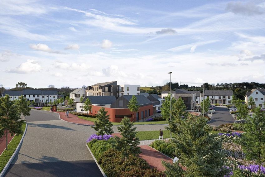
November 2019                                            Longview Estates Ltd EIAR Chapter 2

Two no. vehicular accesses are proposed from the Ballyhooly Road and one no. access to /
from the local road to the north of the site (pedestrian access points will also be allowed to
the local road to the north), all including local road widening within applicant lands,
resurfacing and boundary works. Signalisation of the Lower Dublin Hill / Ballyhooly Road
Junction is also proposed along with the provision of a new bus stop on the eastern side of
the Ballyhooly Road close to the junction of Lower Dublin Hill and the Ballyhooly Road. The
application also provides for the reservation of lands to accommodate the widening of the
Ballyhooly Road and the provision of new pedestrian and cyclist infrastructure along the
eastern side of the Ballyhooly Road with crossing of same close to Mervue Lawn south of
the proposed development. Groundworks, excavation and ground reprofiling are required
and proposed to provide a Distributor Road through the site and all development areas
internally within the site. The proposed development also provides for the line diversion and
partial undergrounding of the Kilbarry-Flaxfort-Mayfield 38kv line that traverses the
landholding east / west, the removal of existing pylons and the provision of two new pylons
one in the Lahardane Townland and one in the Ballincolly Townland and landscaping works
within the 110 kv power line wayleaves that also traverse the site.

The site is located in the Ballyvolane Urban Expansion Area (UEA). This is an area that has
been identified in statutory policy documents as growth location for residential and other
associated uses.

                                                                               Chapter 2/pg.3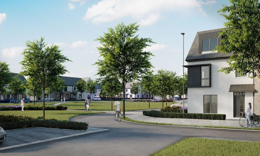
November 2019 Longview Estates Ltd EIAR Chapter 2
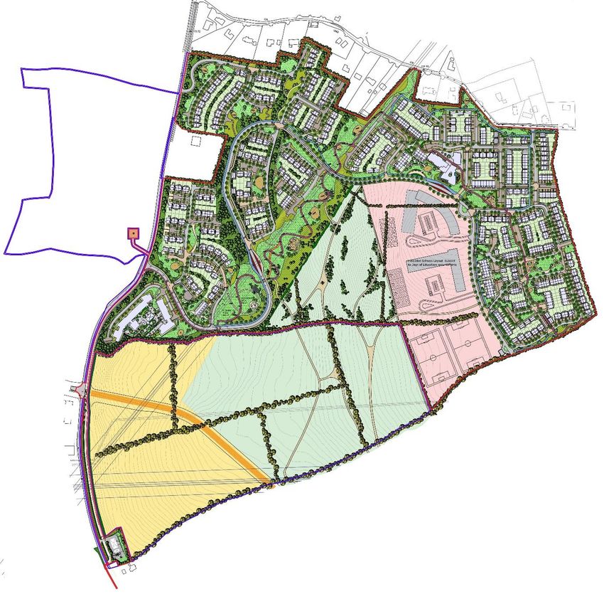
Figure 2.1 Proposed Site Layout
Chapter 2/pg.4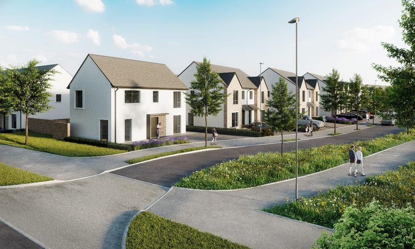
November 2019 Longview Estates Ltd EIAR Chapter 2
2.2 Planning Application Site Location and Description
The site the subject of this Strategic Housing Development application is located in the
townlands of Lahardane and Ballincolly, Ballyvolane, Cork within the administrative area of
Cork City Council. The application site forms part of an area which has been promoted as a
growth location to accommodate a significant increase in population since the Cork Area
Strategic Plan (CASP) was published in 2001.
The planning application site, of 46.9 Ha, as outlined in figure 2.2 is located to the eastern
side of the Ballyhooly Road (R614). This is an important regional route linking the City
Centre of Cork through Dillons Cross and St Lukes and to the northern environs including
upper Glanmire, Watergrasshill and Carrignavar through Whites Cross. The lands are
situated less than 3km to the north east of the City Centre and just 1.5km to the north of
Ballyvolane District Centre. The lands are currently accessible from the Ballyhooly Road and
the local road to the north of the site. .
The application site is generally open in character, comprising fields which are currently in
agricultural use. The topographical survey included with this planning application shows the
very significant level changes particularly to the west of the site. The site levels increase
from approximately 65m OD on the western side of the site to 130m OD in the eastern part.
There are no recorded architectural heritage or archaeological sites located within the
proposed development site. There are no buildings of any date located within the site.
As the site is within the ‘Transition Area’ i.e. the area was within the administrative district of
Cork County Council before the boundary extension in May 2019, the planning application
site is subject to the land use policies and objectives of the Cork County Development Plan
2014. The site is also subject to the policies within the Cobh Municipal District Local Area
Plan 2017.
The site forms part of a designated urban expansion area and is zoned for the following
uses:
NE-R-08 and NE-R-09 for Medium B residential development;
NE-C-01 for proposed primary and secondary school campus with playing pitches
NE-O-04 open space for public recreation as an urban park. The amenity parkland
should provide passive amenity for residents of the north eastern suburbs and the
site. It should also contain the necessary walkways and cycle ways for accessibility
between residential, business, retail and community uses.
NE-U-03 and NE-U-04 for service roads within the Ballyvolane Urban Expansion
Area.
Chapter 2/pg.5
November 2019                                           Longview Estates Ltd EIAR Chapter 2

Figure 2.2 Site Location in Northern Environs of Cork City

2.3 Immediately Adjoining Lands

The site area is generally characterised by agricultural and residential development. Beyond
the northern boundary there are a small number of “one-off” dwellings which are accessed
from the local roadway to the north. To the south of the site there are fields which also form
part of the zoned lands within the UEA. These are currently in agricultural use. As indicated
on the site location map for this planning application, the applicant owns a large portion of
the land to the south of the site which is bordered to the west by the Ballyhooly Road. The
applicant has made a commitment to Cork City Council to keep these lands free of
development until a decision is made regarding the final alignment of the proposed link road
which will connect the Ballyhooly Road and the Northern Relief Road in Mayfield. The
alignment is indicated as running through the applicants’ lands in the Cobh Municipal District
Local Area Plan (LAP).

There are open fields to the east of the site which form part of the urban expansion area.
Pedestrian and vehicular access from the applicant’s site to these lands will be possible
when they are developed. The Ballyhooly Road borders the site to the west. There are two
accesses proposed from the Ballyhooly Road.

                                                                               Chapter 2/pg.6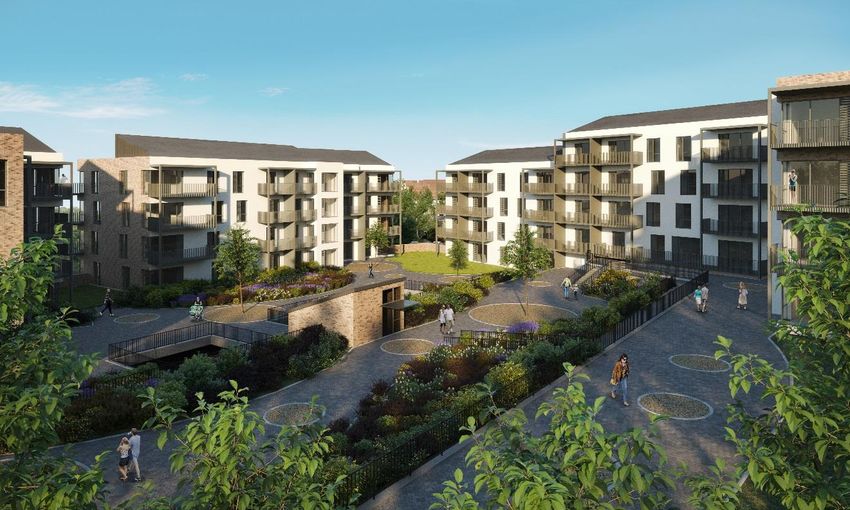
November 2019                                            Longview Estates Ltd EIAR Chapter 2

Figure 2.3 Planning Application Site and Surrounding Area

2.4 Wider Site Context – Land Use

In the 2011 Local Area Plans prepared by Cork County Council, a number of strategic policy
areas were identified and zoned for development in the Metropolitan area of Cork. The
application site was located in an area designated as X-01, a zoning that provided for “an
objective to facilitate the development of a minimum of 2,337 and up to 3,600 dwellings on
this site through a phased programme of development that will secure the timely provision of
the necessary physical and social and economic infrastructure”. Development was intended
to be on a Masterplan basis. This was not achieved / achievable and the County Council in
2017 reverted to a conventional zoned approach for the Urban Expansion Area as they did
for the X-0 zoned lands throughout the City Environs (and satellite towns where applicable).

Nine sites were identified during the preparation of the 2017 LAPs as Urban Expansion
Areas (UEA) and zoned in a “conventional” manner so as to allow delivery as landholdings
came forward. The planning application site forms part of one of nine UEAs throughout
County Cork. These are priority development areas which have the capacity to deliver about
22,000 housing units in Metropolitan Cork. The planning and implementation strategies to
secure the delivery of these sites was noted as being a priority of the Council in the Cobh
MD LAP 2017.

The applicants’ site is the first substantial land bank to be proposed for development within
the Ballyvolane UEA and, if permitted, will open up opportunities for significant further future
development with the infrastructural proposals (Distributor Roads and Irish Water Pumping
Station) included as part of this planning application. Existing residential development in the
area includes more mature and established housing schemes to the south/ south east of the
                                                                                  Chapter 2/pg.7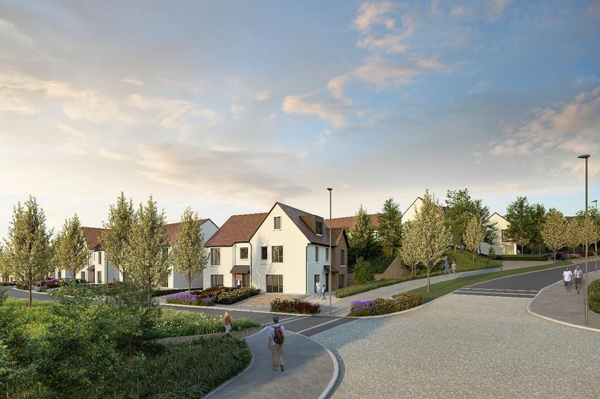
November 2019                                             Longview Estates Ltd EIAR Chapter 2

site such as Brookwood, Kinvara Close/ Avenue, Mervue Lawn, Glenthorn Mews/ Park and
Meadow Park and “one-off” houses along the northern boundary of the site. As the demand
for housing has sustained due to the improved economy, there has been a significant rise in
residential development in other areas of Cork but, to date, development in the Northern
Environs of the city including Ballyvolane has been limited. The only recent housing
developments in the site area permitted by Cork County Council include planning ref.
17/6781 for the construction of 74 no. residential units, located to the north-west of the site in
2018 and planning ref 19/5326 for the construction of 20 no. residential units on the Banduff
Road in 2019.

Other uses in the wider area include commercial, industrial, retail, educational and
recreation. The Ballyvolane district centre is located c. 1.5km to the south of the site on the
Ballyhooly Road. The district centre includes Ballyvolane Shopping Centre consisting of
Dunnes Stores and smaller retail uses such as a pharmacy, butchers and café. There is a
Lidl approximately 1.2km to the south of the site. As indicated in Figure 2.8, the LAP zoning
map proposes a significant expansion of the Ballyvolane district centre to serve the new
population in Ballyvolane. City North Business Park is located 1km to the west of the
planning application site on Upper Dublin Hill and includes a number of established
businesses such as Flextronics Wireless Ltd., Yves Rocher, Cavanagh Refrigeration,
Southern Pumps and Auto Express

Further to the west, Blackpool is circa 2.5km from the site. Blackpool is a key suburban
centre that provides significant employment and services in the Blackpool shopping centre
which is a designated district centre, Northpoint Business Park, and Gateway Business Park.
Blackpool has an emerging IT sector with Irish companies such as Teamwork.com, Xandu,
Westbourne IT Global Services and Texuna and international companies including Blizzard
Entertainment and IBM located there.

Cork City Centre which is the economic, social and cultural core of the region is located less
than 3km from the site. The nearest existing bus stop to the site is 300m from the main site
entrance, outside Brookwood housing estate to the south west of the site. This bus stop
serves the 207 bus route that runs between Ballyvolane and Donnybrook in the southern
environs via Cork City Centre. The proposed development will help to facilitate the National
Transport Authority supported Ballyvolane Strategic Transport Corridor (BSTC) project which
proposes significant improvements to Route 207 with the aim of decreasing journey times
and enhancing public facilities.

The BSTC scheme has received funding with the works proposed to be complete in the first
quarter of 2023. The proposed development allows for road widening, setbacks, and the
provision of cycle and pedestrian paths on the Ballyhooly Road and a bus stop on the
eastern side of Ballyhooly Road. Bus stops and a turning area are also proposed within the
site itself. These infrastructural improvements will encourage modal shift to occur in the area,
and for the future residential communities on the subject lands.

                                                                                  Chapter 2/pg.8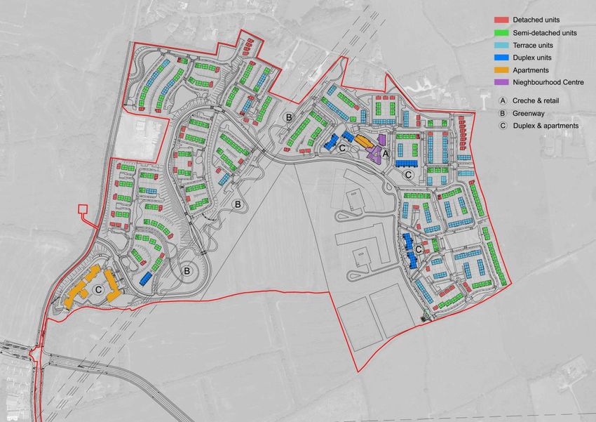
November 2019                                          Longview Estates Ltd EIAR Chapter 2

Figure 2.4 Existing Commercial, Industrial and Retail Uses in the Wider Site Area

   Existing Commercial, Industrial and Retail Uses
   in Site Area

       1- Ballyvolane Shopping Centre (Dunnes
          Stores)

       2- Lidl

       3- Filling Station

       4- Blackpool Shopping Centre

       5- City North Business Park

       6- Blackpool Retail Park

       7- Sunbeam Industrial Estate

       8- Northpoint Business Park

                                                                             Chapter 2/pg.9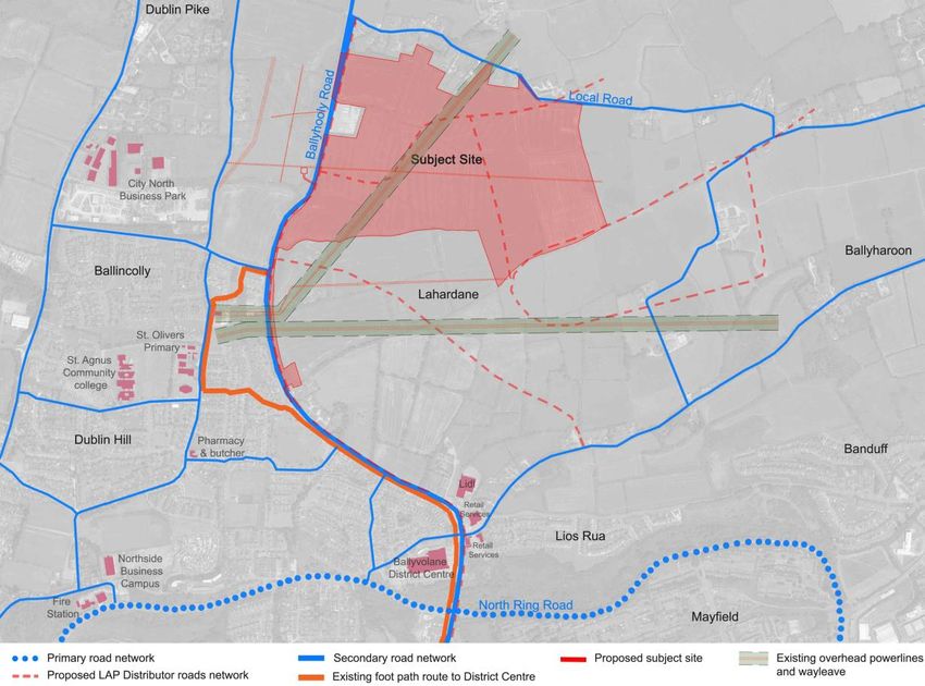
November 2019                                             Longview Estates Ltd EIAR Chapter 2

There are a number of schools within the site catchment, the closest being Scoil Oilibhéir
primary school and St Aidan’s Community College (secondary school) which are less than
1km away to the west of the site. Further detail on school provision is provided later in
Chapter 4 of the EIAR.

Figure 2.5 Schools within the Site Catchment

Sport and recreation uses in the area include Glen Rovers Hurling Club, Leeds AFC,
Delaneys GAA Club, the Glen Park, Kempton Park, Mayfield Leisure Centre and the Glen
Resource and Sports Centre. The Glen Resource Centre includes a number of soccer
pitches, artificial surfaces suitable for all sports and outdoor adventure activities and obstacle
courses suitable for all ages. Mayfield Sports Complex is also located close to the site. The
complex contains a 25m pool, gym and astro turf pitches.

                                                                                Chapter 2/pg.10
November 2019 Longview Estates Ltd EIAR Chapter 2
Figure 2.6 Existing and Proposed Parks and Recreation Facilities in the Site Area
2.5 Planning Policy Context of the Site
The development of this site must be considered in the context of national, regional, and
local planning policies and guidance. This section gives a brief summary of the current
planning policy context. A detailed standalone Statement of Consistency with the relevant
planning policies has been prepared by Cunnane Stratton Reynolds and accompanies this
planning application.
2.5.1 National Planning Policies and Guidance
The National Planning Framework (NPF) – Project Ireland 2040 is the Governments high
level strategic plan for shaping the growth and development of Ireland to 2040. Project
Ireland represents an important shift from previous approaches to long-term planning and
investment by Government. It is an approach that joins up ambition for improvements across
the different areas of people’s lives, bringing the various government departments, agencies,
State owned enterprises and local authorities together behind a shared set of strategic
objectives for rural, regional and urban development.
Cork is Ireland’s second largest city and the NPF sets out ambitious growth targets for it to
become a city of scale and a regional driver as a viable alternative to Dublin. The population
of the city is expected to increase by 50-60% by 2040. The NPF encourages investment to
improve Corks offer i.e. its infrastructure, quality of life and choice in terms of housing,
employment and amenities.
The NPF notes that one of the greatest challenges facing Cork is addressing the long term
decline of the City’s population. A key growth enabler for Cork specified in the NPF is
progressing the sustainable development of new greenfield areas for housing, especially
those on public transport corridors.
Chapter 2/pg.11November 2019 Longview Estates Ltd EIAR Chapter 2
The NPF sets out national planning policies to encourage more compact urban growth rather
than sprawling cities and towns to support more sustainable development to tackle climate
change and congestion. Project Ireland restates the commitment to implement statutory
planning guidelines – the Sustainable Residential Development in Urban Areas guidelines
2009. These guidelines encourage increased densities in city and town centres, on
brownfield sites (within city and town centres), on public transport corridors, inner suburban/
infill sites, on institutional lands and outer suburban/ greenfield sites.
The planning application site would be considered as open land at the periphery of the city.
The guidelines state that the greatest efficiency in land usage on such lands will be achieved
by providing 35-50 dwellings per hectare and development at net densities less than 30
dwellings per hectare should generally be discouraged in the interest of land efficiency. The
proposed development has been designed in accordance with the Sustainable Residential
Development in Urban Areas Guidelines and the accompanying Urban Design Manual which
includes the 12 design criteria for good urban design.
The National Development Plan 2018-2027 was published at the same time as Project
Ireland 2040 and is fully integrated with the new approach to spatial planning in the NPF.
Resolving the systemic factors underlying the current housing crisis is at the heart of the
NPF and reflecting this, housing and sustainable urban development is a priority for the
National Development Plan. The NPF outlines the national strategic objectives to be
achieved with the National Development Plan illustrating the committed investment in
implementing the NPF’s objectives.
The proposed development is consistent with national planning policies and guidance as it
will make a significant contribution to the population of Cork City at a location which has
been prioritised for growth for some time. Despite the significant challenges of developing
these lands, a density of 35.5 dwellings per hectare has been achieved in accordance with
national density standards.
2.5.2 Regional Planning Policies
The vision of the South West Regional Planning Guidelines 2010-2022 is as follows:
“By 2022, the South West Region will be realising its economic potential and providing a
high quality of life for its people by meeting their employment and housing, educational
and social needs in sustainable communities. At the same time, it will reduce its impact
on climate change and the environment, including savings in energy and water use and
by strengthening the environmental quality of the Region”.
The guidelines state that the priority for population growth in the region will be in the Cork
gateway. The primary focus in Cork City will be on brownfield sites such as Docklands and
Blackpool and in the suburban areas Ballyvolane and Mahon.
The South West Regional Planning Guidelines are now effectively superseded by the Draft
Regional Spatial and Economic Strategy (RSES) for the Southern Region. The RSES was
issued for public consultation between 18th December 2018 and 8th March 2019 and the
Material Amendments and associated Environmental Reports published for consultation
between 12th September and 11th October 2019. The Regional Spatial and Economic
Strategies will provide a long-term regional level strategic planning and economic framework
in support of the implementation of the National Planning Framework. The vision for the
Southern Region is to:
Chapter 2/pg.12November 2019 Longview Estates Ltd EIAR Chapter 2
“Promote the Southern Region as an attractive, competitive and sustainable place to live,
work and visit, a region of considerable opportunity for growth based on the quality of its
cities, towns and rural areas, well developed physical and social infrastructure, a diverse
modern economy and a pristine natural environment”.
The NPF targets significant growth and development in all five of Ireland’s cities. To achieve
this, Metropolitan Area Strategic Plans (MASPs) have been designated in the NPF as the
appropriate vehicle to address both the city and suburbs and adjoining area that supports
the core of the city. In line with the RSES’, the MASPs will be provided with statutory
underpinning to act as 12-year strategic planning and investment frameworks for the city
metropolitan areas, addressing high-level and long-term strategic development issues.
Objective 1 of the Draft Cork MASP includes the following:
a. Strengthen the role of the Cork Metropolitan Area as an international location of
scale, a complement to Dublin and the primary driver of economic and population
growth in the Southern Region.
b. To promote the Cork Metropolitan Area as a cohesive single functional entity where
population and employment growth is integrated with: (i) the city centre as the
primary location at the heart of the metropolitan area and region reinforced by (ii) the
continued regeneration, consolidation and infrastructure led growth of the city centre,
Cork City Docklands, Tivoli and suburban areas (iii) active land management
initiatives to enable future infrastructure led expansion of the city and suburbs (to be
assessed by Core Strategy initiatives) and (iv) the regeneration, consolidation and
infrastructure led growth of metropolitan towns and other strategic employment
locations in a sustainable manner.
c. Seek co-ordinated investment and delivery of holistic infrastructure packages across
State Departments and infrastructure delivery agencies as they apply to the Cork
Metropolitan Area and seek further investments to deliver on the Metropolitan Area
Goals
d. The Cork MASP allows flexibility to respond to changes in planning policy,
infrastructure requirements and prioritises that will arise in the area which will be
added to Cork City as a result of the boundary extension, framed by the principles set
out in RPO 8 Compact Growth in Metropolitan Areas, other objectives of the Cork
MASP and MASP Goal 7 in Appendix 3 (of the RSES).
The Draft MASP sets out the strategic housing and regeneration areas. The North Environs
is one of these areas and the Ballyvolane Urban Expansion Area is identified as having a
potential residential yield of 3,600 units.
The Draft RSES makes reference to the Draft Cork Metropolitan Area Transport Strategy
2040 (CMATS). The Draft CMATS was published in May 2019. CMATS recognises the
major role that the North Environs will play in rebalancing the city in terms of future
population and employment growth. It notes that development to provide the homes and jobs
that are necessary to serve the planned population will be prioritised in the following
locations in the Cork Metropolitan Area – Carrigaline (Shannon Park), Midleton (Water Rock)
and Carrigtowhill (North of the railway), Ballincollig (Maglin), North Environs (Ballyvolane),
Glanmire (Dunkettle), Blarney (Stoneview), Monard and Cobh.
The Draft RSES does not identify CMATS as a requirement for the development of
Ballyvolane in the same way as it specifically refers to necessary requirements for the other
Chapter 2/pg.13November 2019 Longview Estates Ltd EIAR Chapter 2
expansion areas including Monard and Cobh. Of all the strategic growth locations identified,
Ballyvolane does not require major public transport infrastructure of either a new train station
or CMATS related infrastructure. It is clear from CMATS that the Cork North Ring Road is a
long term plan. The National Development Plan indicates that the North Ring Road is a
complementary but independent scheme to the N/M20 corridor scheme. However, its
requirements, scale (based on demand levels) and justification will be considered and
assessed as part of the appraisal process for the overall M20 scheme. It is envisaged that
the North Ring Road would not be delivered in advance of the substantive public transport
elements of the regional strategy.
CMATS requires additional road network infrastructure on the north side of Cork City to cater
for access to the planned development lands (the UEA). These will provide walking and
cycling linkages, access to radial public transport routes, orbital public transport provision
and the removal of some strategic traffic from the City Centre. This new road will be the Cork
Northern Distributor Road. The Cork Northern Distributor Road is a short-term objective and
considered to be a critical enabler.
The proposed development is not reliant on either of these roads for access. In fact the
proposed Northern Distributor Road known as the Mayfield Link Road in the Cobh MD LAP
is shown through lands in the applicant’s ownership. These lands do not form part of this
planning application. They are being kept free of development until the final alignment of the
Link Road has been decided so as not to interfere this this road infrastructure.
Chapter 2/pg.14November 2019 Longview Estates Ltd EIAR Chapter 2
Figure 2.7 Proposed Road Network 2040 as illustrated in the Draft CMATs with Planning
Application site location indicated with red star
In the short term CMATS does propose improvements to the pedestrian and cyclist network
on the Ballyhooly Road. Dublin Hill to Ballyhooly Road is identified as a key secondary cycle
route. The Ballyhooly Road is also identified as part of the Bus Connects priority route. The
improvements to the Ballyhooly Road are allowed for as part of the proposed development
and the Ballyvolane Strategic Transport Corridor Project: North Ring Road to Ballincolly,
June 2019 – now instructed and design work commenced for Cork City Council for delivery
in 2021. The road setbacks incorporated into this scheme, in the applicant’s landholding,
have been agreed with the City Council in advance of making the application and allow for
the permanent setbacks envisaged by the Council.
2.5.3 Local Planning Polices
The site forms part of the area that was transferred from Cork County Council to the Cork
City Council jurisdiction in May 2019. Notwithstanding the fact that the site is now in the City
Council area, the policies and objectives of the Cork County Development Plan 2014 remain
in force as per Section 30 (1) of the Local Government Bill 2018 which states that “the
development plan in force immediately before the transfer day in respect of the functional
area of the county council shall, on and after that day, continue to apply in respect of the
relevant area until the next making of a development plan by the city council in respect of the
functional area of the city council in accordance with section 9 of the Act of 2000”.
The vision for the County as set out in the Development Pan is as follows
“Through the application of the planning principles set out in this document, to provide for
the development of County Cork as an attractive, competitive and sustainable place to
live, visit and do business, where the quality of its economy, natural and built environment,
culture and the strength and viability of its communities are to the highest standards”.
Chapter 2/pg.15November 2019 Longview Estates Ltd EIAR Chapter 2
The key aims for the County are summarised in Chapter 2 (Core Strategy) of the
Development Plan as follows:
a) Enhanced quality of life for all
b) Sustainable patterns of growth in urban and rural areas
c) Sustainable and balanced economic investment
d) An effective physical and community infrastructure
e) A quality built environment
f) A network of enhanced natural resources
g) Responsible guardianship of the County.
The site forms part of the Northern Environs in the Cork Gateway. The strategic aim for the
North Environs is set out in policy objective CS 3-1 which seeks “growth in population and
employment so that the Cork Gateway can compete effectively for investment and jobs.
Develop to complement and consolidate the development of the city as a whole and
providing enhanced potential to rebalance the City through new development in the north”.
The Development Plan prioritises growth in the North Environs. Policy objective CS 4-1 (n)
states “in the Cork gateway, development to provides the homes and jobs that are
necessary to serve the planned population will be prioritised in the following locations:
Carrigaline (Shannon Park), Midleton (Waterock) and Carrigtwohill (North of the railway),
Ballincollig (Maglin), North Environs (Ballyvolane), Glanmitre (Dunkettle), Blarney
(Stoneview), Monard and Cobh. Details of the proposed development will be set out in
Master Plan studies and Local Area Plans as appropriate”.
Under policy objective HOU 3-1 (a) the Plan states that it will “ensure that all new
developments within the County support the achievement of sustainable residential
communities. The Council will have regard to the provisions of the Guidelines on Sustainable
Residential Development in Urban Areas and the accompanying Urban Design Manual, in
development plan preparation and in assessing applications for development through the
development management process”.
As noted the site is within the Ballyvolane Urban Expansion Area. The Cobh Municipal
District Local Area Plan (MD LAP) 2017 notes that the Development Plan provides for the
population of the northern suburbs to grow to 10,719 persons, representing a growth of
4,027 persons on the 2011 population. The overall design of the lands has been guided by a
number of factors. These include constraints within the site, the brief produced for the
masterplan process and National and local guidelines.
The constraints as outlined in the LAP include the topography, existing road infrastructure,
the location of archaeological and heritage features, transmission lines and the necessary
wayleaves. The Sustainable Residential Development in Urban Areas Guidelines
recommendations on density and public transport are also noted in the LAP as being
particularly important for this site as it is an expansion of the city suburbs.
The LAP sets out the key principles for the sustainable development of the site as follows:
Chapter 2/pg.16November 2019 Longview Estates Ltd EIAR Chapter 2
Ensure that the proposed development provides effective connectivity (walking and
cycling) to the town centre, educational and employment centres for future residents;
Support the achievement of high levels of modal shift by collaborating with other
agencies to improve public transport services and influence patterns of employment
development to support use of sustainable modes and travel by public transport;
Ensure the provision of an appropriate housing mix, considering the changing
demographic (needs of older people) and the housing market requirements for
Metropolitan Cork and the requirement of the Social Housing as per the County
Development Plan 2014;
Make provision for housing density that encourages more efficient land use and
infrastructure investment patterns and particularly creates conditions more favourable
to the increased use of public transport; and
To achieve development areas with a distinctive character that ensures a unique,
innovative and distinctive design of houses with high quality finishes and materials.
They should include positive characteristics such as reference to topographical and
historical features and the inclusion of individual focal points and a priority for the
provision of high quality.
The approach to the zoning of the subject lands has changed since the 2011 LAP in which
the site was zoned as a Special Policy Area – X-01 which set out objectives for the
development of the site. In the current LAP, the X-01 special policy area has been divided
into smaller parcels of specific zonings.
The planning application lands are zoned as NE-R-08 and NE-R-09 for Medium B residential
development; NE-C-01 for proposed primary and secondary school campus with playing
pitches; NE-O-04 for open space for public recreation as an urban park. The amenity
parkland should provide passive amenity for residents of the North Eastern suburbs and the
site. It should also contain the necessary walkways and cycle-ways for accessibility between
residential, business, retail and community uses and NE-U-03 for a service road within the
Ballyvolane.
Chapter 2/pg.17November 2019 Longview Estates Ltd EIAR Chapter 2
Figure 2.8 Planning Application Site Zonings as per the LAP (Planning Application site
outlined in red and Applicant ownership in blue)
The MD LAP sets out indicative phases of development for the LAP lands. The proposed
development is compliant with the indicative phasing programme and the developments
consistency with same is set out in further detail in the accompanying Statement of
Consistency and Planning Report.
The LAP also sets out general development objectives for Cork City North Environs. These
include:
NE-GO-01: It is the aim of the Urban Expansion Area to achieve a high quality
housing development consisting of a wide mix of house types and design to provide
a choice of housing suitable to all age groups and persons at different stages of the
housing cycle. It is envisaged that up to 3000 units can be accommodated on site,
however, having regard to the steep topography in parts of the site the number of
units may be less. Higher densities will be promoted closer to the Ballyvolane
crossroads, and the city boundary to avail of more frequent and high quality bus
service in line with the Sustainable Development Guidelines on Urban Areas. A total
of 10% of new housing development is reserved for the purpose of Part V social
housing and/ or specialised housing needs.
NE-GO-02: In order to secure the sustainable population growth and supporting
development proposed in NE-GO-01, appropriate and sustainable water and waste
water infrastructure that will secure the objectives of the relevant river basin
management plan must be provided and be operational in advance of the
commencement of any discharges from the development. Waste water infrastructure
Chapter 2/pg.18November 2019 Longview Estates Ltd EIAR Chapter 2
must be capable of treating discharges to ensure that water quality in the receiving
harbour does not fall below legally required levels.
NE-GO-03: The design of residential development should be fine grained with
houses of a particular type clustered in quite small groups avoiding continuous rows
of development. House designs and layouts should be responsive to localised
variations in their environment – including topography, orientation, retained features
and recreational infrastructure. Avoid use of conventional house design with
substantial use of retaining walls on sloping contours, house design should utilize the
level difference within the site to an advantage.
NE-GO-04: Construct a permeable built form with green routes to facilitate cycling
and pedestrian movement within the site, with dedicated routes in locations with a
shallower gradient. Routes should be created within the urban park to link phases of
development and provide direct access to the educational facilities and improve
permeability through the site. The route of the principal cycleway shall link up with
Cork Cycle Network Plan 2017, a joint venture between City and County Councils.
NE-GO-05: Retain a substantial proportion of existing landscape features including
field banks, hedgerows, tree lines and masonry walls. Provide a landscape
framework plan for each of the six phases of development as part of a landscape
strategy. Provide for advanced mix planting of coniferous and broadleaf trees to
ensure year round tree coverage to protect the visual amenity of the area.
NE-GO-06: Design an integrated approach to surface water management which
considers land use, water quality, amenity and habitat enhancements, thereby
replicating the current greenfield rate of surface water runoff, post development, to
prevent flooding of lands and settlements downstream. A Sustainable Urban
Drainage Strategy should be completed for the site prior to development.
NE-GO-07: Create an ecological network by linking green areas to allow for
movement of wildlife. All environmental resources should be incorporated from
waterways to woodlands to adopt a green infrastructure approach within the site with
links to the surrounding countryside. Open spaces for public recreation including the
provision of playing pitches, amenity walks, children’s playground, open parkland,
subject to appropriate scaling and siting.
2.6 Description of the Physical Characteristics of the Proposed Development
Characteristics of the Proposed Development
The description of the proposed development has been set out previously. A ten year
planning permission is sought for the proposed development of 753 no. dwellings over 6
phases of development and a local centre consisting of a crèche, doctors surgery, retail and
community use. The proposed development also includes public parkland, greenway, open
spaces and play areas, associated internal roads, pedestrian and cycle paths, boundary
treatments, general landscaping, public lighting, internal bus stops and turning area and all
site services infrastructure.
This section describes the characteristics of the proposed development in more detail.
There is no demolition of any structures proposed as part of this development. In summary,
the proposed development comprises the construction of 753 no. dwellings consisting of 531
Chapter 2/pg.19November 2019 Longview Estates Ltd EIAR Chapter 2
no. houses 153 no. apartments and 69 no. duplex units. A wide variety of dwelling
typologies are included in the proposal, comprising 153 no. apartments in studio,1, 2 and 3
no. bedroom units in 3 no. apartment buildings along with 69 no. duplex units, in a series of
buildings located in neighbourhoods 1,2 and 5 within the development. The duplexes and
apartments comprise of 29% of the overall units within the proposed development. In
addition it is proposed to provide 531 no. 2, 3, 4 and 5 bedroom dwellings in a range of
typologies comprising terraces, semi-detached and detached configurations.
2.6.1 Design and Layout
The planning application is accompanied by a Design Statement prepared by Horgan Carroll
Architects which sets out the design strategy for the proposed development. It is expected
that the development will be constructed over six phases and it includes 6 no.
neighbourhoods. The layout of the neighbourhoods has been formed from the alignment of
the distributor road which provides access from the Ballyhooly Road and runs through the
site from west to east providing access to individual neighbourhoods, the lands zoned for a
school campus and providing potential access to undeveloped lands to the south east of the
site in the future.
The proposed greenway/ urban park and the local centre are distinct elements of the
proposed development and will act as focal points and be recognisable features within the
scheme. The houses will be 2 to 3 storeys, the duplex units 4 storeys and the apartments 4-
6 storeys. The taller buildings are located centrally within the site close to the local centre
and in neighbourhood 6 close to the bus stop on Ballyhooly Road. The house types and
palette of materials proposed has been carefully considered to provide a coherent and mixed
variety to the overall development that will contribute to the locality. This is evident from the
images included below.
The principles of the Design Manual for Urban Roads and Streets (DMURS) have been
incorporated into the design of the development's roads, to clearly define a hierarchy which
aims to improve legibility throughout the scheme. The proposed development has sought to:
a) Assign higher priority to pedestrians and cyclists, without unduly compromising
vehicle movement, in order to create secure, connected places that work for all
members of the community.
b) b) Create attractive places to live.
c) Facilitate walking and cycling as alternative modes of transport (both in the layout of
spaces and the provision of walks, cycle paths and ample cycle parking).
d) Deprioritise the car, accommodating it where necessary (the distributor road) and
controlling its design effect in the housing areas.
2.6.2 Unit Types and Mix
The proposed development will consist of a wide mix of unit types and sizes including
studios, 1 bedroom, 2 bedroom, 3 bedroom and 4 bedroom dwellings in houses, duplexes
and apartments. A full schedule of accommodation is included at appendix 2.1of the EIAR.
The breakdown of unit types and sizes includes:
31 no. 4 bedroom detached houses
36 no. 3 bedroom detached houses
41 no. 4 bedroom semi-detached houses
Chapter 2/pg.20November 2019 Longview Estates Ltd EIAR Chapter 2
237 no. 3 bedroom semi-detached houses
18 no. 4 bedroom terrace houses
96 no. 3 bedroom terrace houses
72 no. 2 bedroom terrace houses
36 no. 3 bedroom duplex units
33 no. 2 bedroom duplex units
6 no. studio apartments
42 no. 1 bedroom apartments
79 no. 2 bedroom apartments
26 no. 3 bedroom apartments.
The proposed unit mix has been developed having regard to the existing housing stock in
the area and the desirability to create a mixed community which provides a choice of
dwelling types and sizes to meet the needs and expectations of people at all stages of the
life cycle. The mix proposed is intended to cater for young professionals, couples and
smaller families and those looking to downsize with smaller units and for families that require
larger units with more space.
Houses
The houses are designed as two and three storey family dwellings, in detached, semi-
detached and terraced buildings. There are 67 no. detached dwellings, 278 no. semi-
detached dwellings and 186 no. terraced dwellings proposed. These are spread throughout
the site in each neighbourhood and will offer choice in accommodation to meet different
family sizes and needs. To allow for future adaptability the majority of dwellings have been
designed to provide the option of an attic conversion or a single/ two storey extension to the
rear as gardens are generally larger than current minimum requirements.
In terms of energy efficiency, the proposed development has been designed to be compliant
with The Building Regulations, Technical Guidance Document Part L, Conservation of Fuel
and Energy – Dwellings, 2019. All residential units are designed to meet Near Zero Energy
Buildings (NZEB) standards. Preliminary Dwelling Energy Assessment Procedures (DEAP)
have been carried out and the results confirm that compliance with NZEB will be comfortably
achieved. The assessments also set out the potential for further and future improvement in
efficiencies of up to 30% with the addition of photo voltaic (PV) technologies. Houses and
apartments will achieve A2 / A3 Building Energy Ratings with the potential for improvement
to A1 with the addition of PV technology.
Houses are designed in excess of current energy efficiency standards and there is potential
for the incorporation of photovoltaic panels and heat recovery systems to enhance further
the efficiency of homes. Passive house principles have been applied in designing the
scheme. The application on of these principles, has resulted in potentially 90% of all units
having the primary, living room i.e. kitchen, dining, living, availing of direct sunlight from the
south east, south and south west. Such an arrangement provides passive solar gain to the
most frequently occupied living space in the home, improving quality of living and directly
Chapter 2/pg.21November 2019 Longview Estates Ltd EIAR Chapter 2
reducing heating and lighting requirements and thus further reducing carbon dioxide
emissions.
Figure 2.9 Houses Neighbourhood 5
Figure 2.10 Neighbourhood 5
Chapter 2/pg.22November 2019 Longview Estates Ltd EIAR Chapter 2
Figure 2.11 Neighbourhood 4
Apartments
The massing and scale of the proposed apartment buildings respond directly to the
topography and positioning at focal points within the site. Neighbourhood 6 consists of the
taller apartment blocks to respond to the steep slope of the area. The apartments along the
Ballyhooly Road provide a distinctive gateway into the development and a focal point along
the road. The form of the apartment blocks allow for an under croft parking area and
apartments on lower parts of the site to compensate for drops in levels. Neighbourhood 2
apartments are designed as a node or focal point within the site close to the local centre.
Chapter 2/pg.23November 2019 Longview Estates Ltd EIAR Chapter 2
Figure 2.12 Proposed Apartments in Neighbourhood 6
Duplexes
There are 69 no. two and three bedroom duplex dwellings proposed in neighbourhoods 1, 2
and 5 of the proposed development.
Figure 2.13 below shows the mix of unit types spread throughout each neighbourhood of the
proposed development.
Chapter 2/pg.24November 2019 Longview Estates Ltd EIAR Chapter 2
Figure 2.13 Proposed Site Layout Plan showing Unit Mix
2.6.3 Local Centre
The development proposes a local centre which includes retail, a doctors' surgery, crèche
facility and community use to serve and support the needs of the proposed development.
The centre is accessible from both within the development and from future surrounding
developments. The crèche and community use are proposed to be single storey buildings.
The crèche has been designed in accordance with the Universal Design Guidelines for Early
Learning and Care (ELC). To the north of the crèche a two storey building with two no.
ground floor retail units and a doctor’s surgery on the first floor is proposed.
Chapter 2/pg.25November 2019 Longview Estates Ltd EIAR Chapter 2
Figure 2.14 Local Centre in Neighbourhood 2
2.6 4 Open Spaces and Landscaping
The open space strategy for the site includes the provision of a circa 3Ha park in phases 2
and 3 as well as a range of green spaces within the neighbourhoods. This creates a corridor
of green spaces that are linked with paths and cycle ways that create a linkage through the
site. The park comprises the wayleave for the 110 kv overhead powerlines as the area
beneath the power lines cannot be built on. The park area also functions as an important
greenway up through neighbourhoods 1, 3 and onto 2. This greenway extends through the
entire site in the form of a combined off road pedestrian and cycle path. This is in addition to
cycle and pedestrian paths along the distributor road. It is a key feature of the green strategy
for the proposed development facilitating an alternative convenient connection through the
site between neighbourhoods, the local centre and the park.
The park area proposed in this planning application includes circulation and boundary
infrastructure that is configured to accommodate ease of connectivity to the wider urban park
land that will be developed in the future. The eastern boundary of the park area proposed in
this planning application where it interfaces with the remainder of the lands zoned for urban
park will be defined by a hedge bank and fence with future linkages indicated when the
remainder of the lands zoned for urban parkland are developed. This will facilitate
maintenance and management of the park with a view to it being taken in charge by Cork
City Council. The landscape masterplan included with this planning application shows
potential circulation and amenity provision in the wider urban parkland to the east.
Chapter 2/pg.26November 2019 Longview Estates Ltd EIAR Chapter 2
Figure 2.15 Proposed 3 Hectare Park within the Site
Figure 2.16 Image of Proposed Park
Chapter 2/pg.27November 2019 Longview Estates Ltd EIAR Chapter 2
The park area facilitates a range of kick about and play areas. An outdoor gym facility is also
proposed within the park. Two amphitheatre structures are proposed to provide opportunities
for resting and socialising and benches will be positioned along the path in the park. The
recreation and amenity strategy has been central to the design development process of the
proposed development. Recreation and enmity provision within the development comprises
a combination of formal and informal features including public open space, local play areas,
neighbourhood play areas, pocket parks along the distributor road, an outdoor gym,
playground facilities and kickabout spaces.
The recreation and amenity strategy for the site has been developed in accordance with the
Cork County Council Recreation and Amenity Policy Interim Approach to Implementation
2019. Seven no. local play areas are proposed in accordance with the recommended
minimum of 1 per 100 no. units and eight no. neighbourhood play areas are proposed in
accordance with the recommended minimum of 1 per 100 no. units. The play areas consist
of compacted Ballylusk gravel surfaces and timber or re-cycled plastic edges located within
grassed open spaces. They provide an alternative to the grass surface for informal play as
well as being functional when the grass areas are wet. On local play area and two
neighbourhood play areas are to be equipped with play facilities to provide an additional
layer of play value. The focus will be on natural play and features within the play areas will
include stepping stones, balance beams and logs, tunnels and grass mounds and integrated
slides.
2.6.5 Access, Car and Bicycle Parking and Public Transport
Access to the Proposed Development
Two no. site vehicular accesses are proposed from the Ballyhooly Road and a third vehicular
access from the local road to the north of the site. The main access from the Ballyhooly
Road will provide for the service/ distributor road through the site as required by local area
plan objective NE-U-03 and NE-U-04 (in part). This distributor road will serve the proposed
development and open up additional lands within the urban expansion area to the east and
south east of the site. It is the only service road sought under planning policy that brings
access from the Ballyhooly Road to lands to the west of the UEA. The service road runs
west to east across the site. The service road runs south along neighbourhood 5 to the west
of the site therefore partly providing for the NE-U-04 service road objective. The service road
runs to the boundary of the applicants site and can therefore be easily extended in the future
to continue service road NE-U-04 and develop service road NE-U-02 to serve additional
lands within the UEA.
Chapter 2/pg.28November 2019 Longview Estates Ltd EIAR Chapter 2
Figure 2.17 Proposed Entrance on Ballyhooly Road
Car and Bicycle Parking
The total car parking requirement for the proposed development based on Cork County
Council car parking standards is 1,389 no. car parking spaces. A total of 1330 car parking
spaces are proposed to serve the development. This is less than the County Council
standards but is considered an appropriate level of parking having regard to the provision of
generous bicycle parking, proximity to bus stops on the Ballyhooly road and the provision of
bus stops internally within the site. A summary car parking schedule is schedule is set out in
Table 2.1. This schedule sets out the car parking provision for each neighbourhood against
the adopted standards. The proposed development includes 591 no. bicycle spaces.
Chapter 2/pg.29November 2019 Longview Estates Ltd EIAR Chapter 2
Table 2.1 Car Parking in the Proposed Development
Existing Public Transport
The existing closest bus stop to the site is located outside Brookwood estate, 300m from the
proposed main site entrance on Ballyhooly Road. The no. 207 bus route serves this stop
which runs from Ballyvolane to Donnybrook via Cork City Centre with a terminus at
Glenheights Park on Glenheights Road and a terminus at Scairt Cross, Donnybrook. The
route serves Glen Rovers Hurling Club, Ballyvolane Business Park, Ballyvolane Shopping
Centre, Cork City Centre and Douglas. The current service takes approximately 20 minutes
from the closest bus stop to the site to the bus station on Parnell Place in the city.
Services depart every 30 minutes from Glenheights between 07.10 to 23.00 Monday to
Saturday and on Sundays from 09.30 to 23.00. The outbound route runs from Donnybrook to
Ballyvolane through Patrick Street with the same frequency as the inbound route. The
inbound route commences at Glenheights Park, travels via Ballyvolane Business Park, east
along the North Ring Road, northeast along Ballyvolane Road past the shopping centre,
then south along Ballyhooly Road through Dillon’s Cross, St. Luke’s and down Summerhill
North, across Brian Boru Bridge to the bus station at Parnell Place before commencing its
southbound part of the route.
Future Public Transport Proposals
The draft Cork Metropolitan Area Transport Strategy (CMATS) includes for bus public
transport enhancements on the Ballyhooly Road. Cork City Council and the National
Transport Authority have instructed consultants to commence the design of such
improvements as of August 2019 – the Ballyvolane Strategic Transport Corridor Project:
North Ring Road to Ballincolly (BSTC). .
The proposed development allows for the future upgrade of the Ballyhooly Road to
accommodate a high frequency bus service with the set-backs that have been incorporated
into the design of the development as agreed with Cork City Council. This is in accordance
with CMATS as it identifies the Ballyhooly Road as a priority route for the proposed Bus
Connects. Enhancing the bus network is consistent with the National Development Plan
2018-2027 which envisages a significantly enhanced Bus Connects service for Cork by
2027. The Ballyvolane Donnybrook bus route forms part of the core radial bus network and
significant improvements to the frequency of these routes are proposed under CMATS.
Chapter 2/pg.30November 2019 Longview Estates Ltd EIAR Chapter 2
The proposed development also includes for the construction of a new bus stop on the
Ballyhooly Road close to the Ballyhooly/ Kilbarry Link Road junction. In addition to this, the
proposal includes for bus stops along the internal distributor road. These are located on the
distributor road between neighbourhood 1 and the greenway and on the distributor road
adjacent to the local centre. A temporary bus turning area is proposed until such a time as
the bus can continue along the distributor road and serve other lands within the expansion
area as they are developed.
There is currently no footpath on the Ballyhooly Road north of Mervue Lawn. Improvements
proposed as part of the development include for the provision of cycle lanes and a footpath
to connect to the existing footpath network to the south of the site. It is proposed to have 2m
wide cycle lanes and footpaths to the east of the Ballyhooly Road for cyclists travelling to
and from Ballyvolane and the City Centre. This is an accordance with the Cork Cycle
Network Plan which envisages a primary cycle route along the Ballyhooly Road from Glen
Avenue to Mervue Lawn with the potential to be extended further north to serve other areas
of the master plan if required.
2.6.6 Childcare and Education
The proposed development includes for the construction of a crèche of 692.88 sq.m in
neighbourhood 2 to be delivered in phase 2/3 of the proposed development. The crèche is
conveniently located next to the local centre and central to the proposed development. The
proposed crèche includes rooms for the various age groups –children aged 0-1 years, 1-2
years, 2-3 years and 3-6 years, kitchen and dining areas, sleep rooms and nappy changing
areas. The crèche has an attractive internal courtyard area and a safe and secure outdoor
play area to the rear.
The crèche can cater for approximately 103 children and has been carefully designed in
accordance with the Universal Design Guidelines for Early Learning and Care Settings 2019.
The size of the crèche was determined by a Childcare Assessment carried out during the
design process and from discussions with the local childcare committee – Cork City
Childcare Committee. The crèche has been increased in size since the Section 5 tripartite
meeting on the basis of advice from Cork City Childcare Committee who advised that it
should be increased to cater for 100 no. children and designed in accordance with the most
recent guidelines (see letter attached at Appendix 2.2).
As noted above, the overall site is partly zoned for a school campus. A School Demand
Assessment was carried out that included a review of enrolment figures in local primary and
secondary schools in the area. The School Demand Assessment concluded that existing
schools should be capable of providing a number of school places for this first phased
tranche of residential development to be proposed in the Ballyvolane expansion area. Given
the sites proximity to the City Centre, it is likely that existing and future children in the
Ballyvolane area will avail of places in popular City Centre schools.
Cunnane Stratton Reynolds liaised with the Mr Alan Hanlon in the Site Acquisition and
Property Management Section of the Department of Education and Skills regarding the site
zoned for a school campus. Mr Hanlon’s response letter noted that “this Department
conducts nationwide demographic exercises into current and future need for primary and
post primary school places across the country and these are constantly monitored and
updated as further demographic information emerges. While this Department has no current
plans for the acquisition and development of the zoned school site at Ballyvolane, this
position will continue to be reviewed as part of those nationwide demographic exercises”.
There is therefore no current requirement for a school campus on this site (see letter
attached at Appendix 2.3).
Chapter 2/pg.31You can also read