AGRICULTURAL IMPACT STATEMENT - DATCP #4255
←
→
Page content transcription
If your browser does not render page correctly, please read the page content below
AGRICULTURAL
         IMPACT
         STATEMENT

         Lakeshore Capacity Improvement
DATCP    Natural Gas Pipeline
 #4255   Racine and Kenosha Counties
         PSC #6630-CG-137

         WISCONSIN DEPARTMENT OF AGRICULTURE,
         TRADE AND CONSUMER PROTECTION
         PUBLISHED MAY 8, 2018
AGRICULTURAL IMPACT STATEMENT

               DATCP #4249
       Lakeshore Capacity Improvement
            Natural Gas Pipeline
        Racine and Kenosha Counties

WISCONSIN DEPARTMENT OF AGRICULTURE,
   TRADE AND CONSUMER PROTECTION

              Sheila E. Harsdorf, Secretary

                 John Petty, Administrator
      Division of Agricultural Resource Management

                  Keith Foye, Director
          Bureau of Land and Water Resources

                Marilyn M. Weiss, Author

                 Published May 8, 2018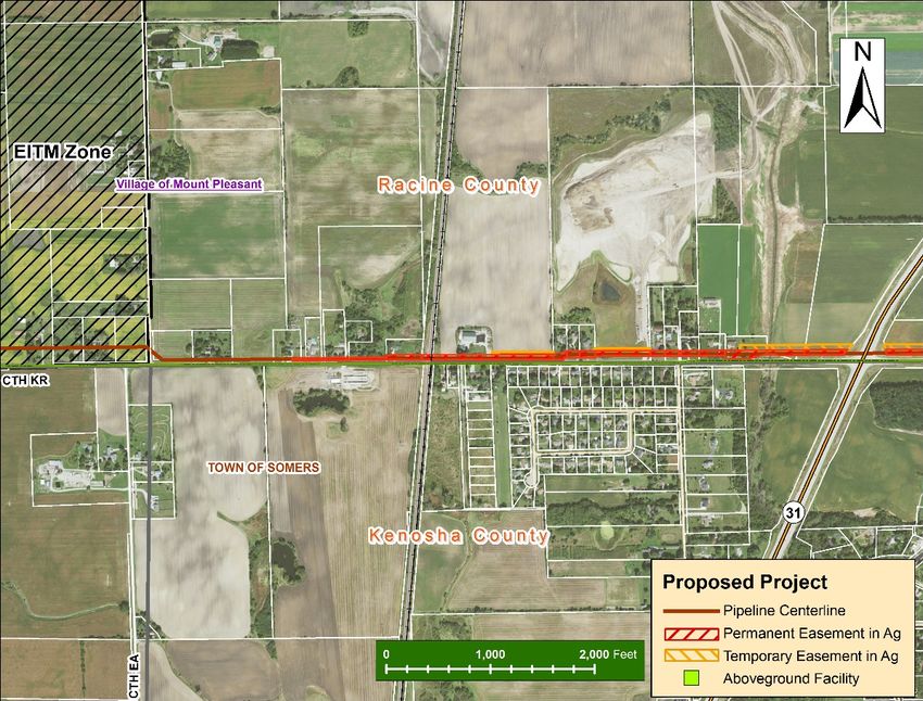
Lakeshore Capacity Improvement Project                                              Agricultural Impact Statement

TABLE OF CONTENTS
DATCP SUMMARY OF ANALYSIS AND RECOMMENDATIONS ..................................................... 1
    Recommendations to the Public Service Commission ..................................................... 1
    Recommendations to We Energies ............................................................................... 1
    Recommendations to Agricultural Property Owners ........................................................ 2
    INTRODUCTION ......................................................................................................... 4
    PROJECT DESCRIPTION .............................................................................................. 6
    Overview.................................................................................................................. 6
    Project Purpose and Need .......................................................................................... 6
    ROW Requirements ................................................................................................... 9
    Trench Dimensions .................................................................................................. 10
    Service Connections ................................................................................................ 10
    PROJECT IMPACTS TO AGRICULTURAL PROPERTIES ..................................................... 11
    Easements ............................................................................................................. 11
    Aboveground Facilities ............................................................................................. 11
    AGRICULTURAL SETTING .......................................................................................... 14
    Agricultural Productivity ........................................................................................... 14
    Land in Agriculture .................................................................................................. 15
    Number and Size of Farms ....................................................................................... 15
    Property Taxes and Values ....................................................................................... 16
    Farmland Preservation ............................................................................................. 17
    Conservation Reserve Program ................................................................................. 17
    Conservation Reserve Enhancement Program ............................................................. 17
    Drainage Districts.................................................................................................... 17
    FARMLAND SOILS .................................................................................................... 18
    Farmland Soil Definitions.......................................................................................... 18
    Farmland Soils Affected by the Proposed Project ......................................................... 18
    Three-Lift Soil Handling............................................................................................ 19
    AGRICULTURAL LANDOWNER IMPACTS ...................................................................... 20
    DATCP Survey of Agricultural Property Owners ........................................................... 20
    Property Owner Comments ....................................................................................... 20
    AMP and BMPs and the Role of the Agricultural Inspector ............................................. 21
    Appraisal and Compensation ..................................................................................... 21
    CONSTRUCTION PROCESS ........................................................................................ 24
    Surveying and Staking ............................................................................................. 24
    Clearing, Grubbing, and Grading ............................................................................... 24
    Pipe Stringing ......................................................................................................... 26
    Bending and Welding ............................................................................................... 26
    Trenching ............................................................................................................... 26
    Lowering-In ............................................................................................................ 27
    Trench Breakers and Tile Repairs .............................................................................. 27
    Backfilling .............................................................................................................. 27
    Horizontal Directional Drilling (HDD) and Jack and Boring ............................................ 27
    Cleanup and Initial Restoration ................................................................................. 28
    Hydrostatic Testing.................................................................................................. 28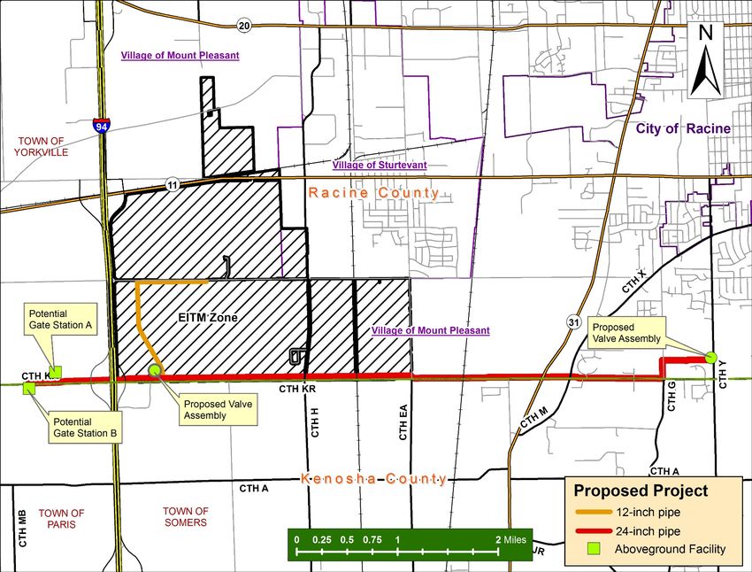
Lakeshore Capacity Improvement Project                                               Agricultural Impact Statement

      Final Restoration .....................................................................................................      28
      POTENTIAL ADVERSE IMPACTS OF PIPELINE CONSTRUCTION ON AGRICULTURE .............                                              29
      Topsoil Mixing .........................................................................................................     29
      Fertile Subsoil Mixing with Underlying Soils (Three-Lift Soil Handling) ............................                         30
      Increased Rock Content of Soil .................................................................................             31
      Soil Compaction ......................................................................................................       31
      Drainage ................................................................................................................    33
      Trench Dewatering ..................................................................................................         34
      Erosion and Conservation Practices ...........................................................................               35
      Crop Rotation and Dairy Operations ...........................................................................               36
      Temporary Access Roads ..........................................................................................            37
      Trees and Other Woody Vegetation ...........................................................................                 38
      Irrigation................................................................................................................   40
      Fencing ..................................................................................................................   40
      Weed Control ..........................................................................................................      41
      Seeding and Seedbed Preparation .............................................................................                42
      Bio-security ............................................................................................................    42
      Organic Farms ........................................................................................................       42
      Induced Current on the Pipe .....................................................................................            43
      Construction Noise and Dust .....................................................................................            43
      CONCLUSIONS ........................................................................................................         45
X.    MAILING LIST .........................................................................................................       47

APPENDIX A: Acronyms .................................................................................................. 48

APPENDIX B: Statutes for Agricultural Impact Statements ................................................... 49

APPENDIX C: Information Sources .................................................................................... 52

APPENDIX D: Three-Lift Soil Candidate Key ....................................................................... 54

APPENDIX E: We Energies Project-Specific AMP and BMPs ................................................... 55

TABLES

Table 1: Acres of Selected Crops Harvested in Racine County .............................................. 15
Table 2: Acres of Land in Farms ....................................................................................... 15
Table 3: Number of Farms and the Average Size of Farms, 1997 and 2012 ........................... 16
Table 4: Farmland Taxes and Values................................................................................. 16
Table 5: Agricultural Soils Potentially Affected by Project .................................................... 19
Table 6: Acres of Potentially Affected Farmland .................................................................. 20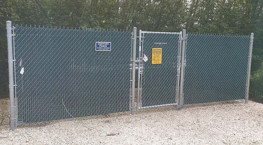
Lakeshore Capacity Improvement Project                                         Agricultural Impact Statement

FIGURES

Figure 1: Project Overview Map ......................................................................................... 7
Figure 2: West End of the Proposed Project ......................................................................... 8
Figure 3: Project Proposed East of the EITM Zone ................................................................ 8
Figure 4: East End of the Proposed Project .......................................................................... 9
Figure 5: Typical Gate Surrounding Aboveground Facilities .................................................. 12
Figure 6: Typical Valve Assembly Facility........................................................................... 12
Figure 7: Gate Station Diagram........................................................................................ 13
Figure 8: Typical Building to be Located in the Gate Station ................................................. 13
Figure 9: Typical Pipeline Construction Cross-Section on Agricultural Land ............................ 25
Lakeshore Capacity Improvement Project Agricultural Impact Statement
DATCP SUMMARY OF ANALYSIS AND RECOMMENDATIONS
The Wisconsin Department of Agriculture, Trade and Consumer Protection (DATCP) has prepared
this Agricultural Impact Statement (AIS) for the proposed Lakeshore Capacity Improvement
Natural Gas Pipeline Project (DATCP #4255) in accordance with Wis. Stat. §32.035. We Energies
submitted project information to DATCP in March of 2018. We Energies proposes to construct
approximately 7.0 miles of 24-inch and 1.7 miles of 12-inch pipeline through the village of Mount
Pleasant and the town of Yorkville in Racine County. No alternative routes are proposed. Two
potential sites are proposed for the project’s one gate station. One site is located in the town of
Yorkville in Racine County and a second site in the town of Paris, Kenosha County. Two valve
assembly facilities are also proposed as part of the project, one located at the eastern end of the
project in the village of Mount Pleasant and another within the Foxconn Electronics Information
Technology Manufacturing (EITM) zone.
Approximately 2.9 miles of the proposed 24-inch pipeline along with all of the proposed 12-inch
pipeline would be located within the EITM zone. Agricultural impacts within the EITM zone have
been described and analyzed in an AIS published on November 10, 2017 (DATCP #4229).
Therefore this AIS excludes all aspects of the project that would be located within the EITM zone.
Outside of the EITM zone, twelve agricultural property owners could be affected by this project.
Four of these property owners could have 2 or more acres impacted, if the project is approved by
the Public Service Commission (PSC or Commission). The Public Service Commission of
Wisconsin (PSC or Commission) is the authority that will approve, deny, or make modifications to
this project. We Energies anticipates submitted an application to the PSC in April of 2018.
DATCP will submit agricultural recommendations to and participate in the PSC process.
Having reviewed all of the materials provided by We Energies and the comments from property
owners, DATCP recommends the following to the Public Service Commission, We Energies and to
agricultural property owners to mitigate impacts on farmland and farmland operations.
Recommendations to the Public Service Commission
If the project is approved by the PSC, DATCP recommends that We Energies work
with Daryl Poisl and Benjamin Coughlin on the final location of the gate station so that
impacts to both of their farming operations from the gate station and the connecting
pipeline are minimized, to the extent practicable.
Recommendations to We Energies
The Agricultural Mitigation Plan (AMP) and Best Management Practices (BMPs)
supplied by We Energies are effective tools in mitigating potential impacts to farm
properties. DATCP recommends that We Energies implement appropriate training for
all construction supervisors, inspectors, and crews to ensure that they understand the
Wisconsin Department of Agriculture, Trade and Consumer Protection 1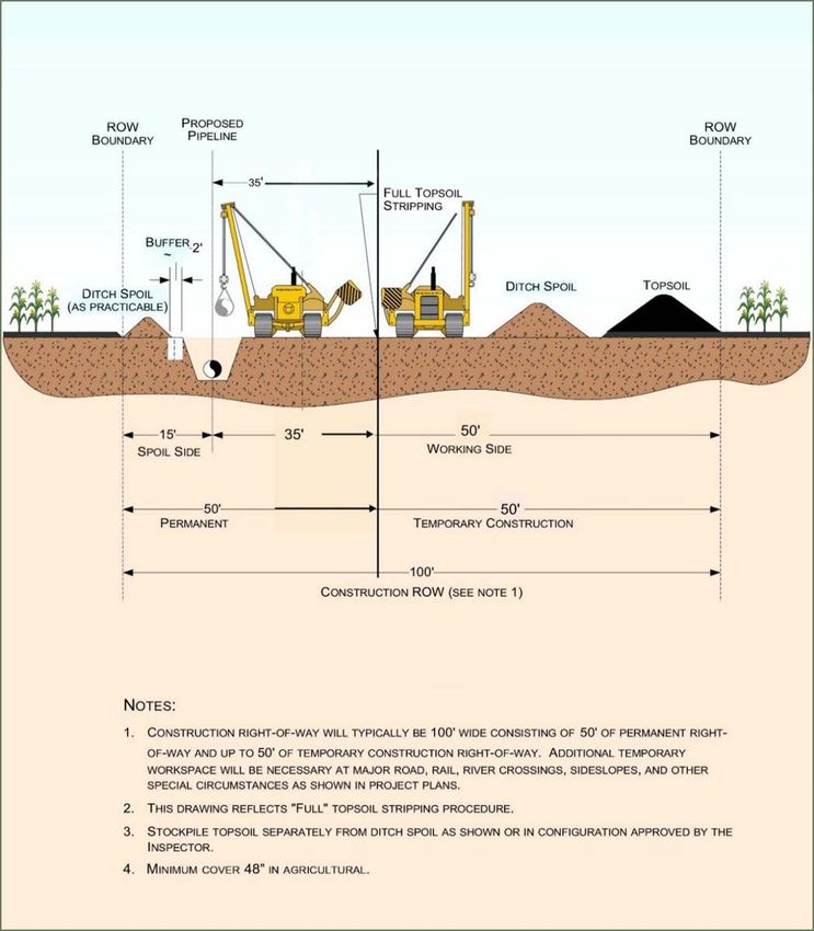
Lakeshore Capacity Enhancement Project Agricultural Impact Statement
implementation of the AMP and BMPs so that the integrity of agricultural lands and
operations during project construction and restoration are protected.
We Energies should inform and work with all agricultural property owners regarding
the potential for natural gas service connection to all properties along the route so
that future development potential is optimized for the affected landowners.
We Energies should ensure that any renters of agricultural land crossed by the
proposed project are kept up-to-date and informed of construction schedules and
potential impacts.
We Energies should work with property owners and renters to minimize construction
impacts to farming operations and infrastructure.
We Energies should work with landowners to restore agricultural properties impacted
by construction activities to pre-construction function and address concerns resulting
from construction.
Where construction activities have altered the natural stratification of the soils
resulting in new wet areas, We Energies should work with the landowner to determine
the means to return the agricultural land either in the ROW or on adjoining lands to
pre-construction function. New drainage tiles, regrading, or additional fill may be
required to correct the problems that arise after construction is completed.
Recommendations to Agricultural Property Owners
We Energies may offer landowners compensation to sign an appraisal waiver form and
offer an easement based on a market study. Landowners have the right to see an
appraisal from We Energies and be compensated for an appraisal prepared by an
appraiser of the landowner’s choice (Wis. Stat. §32.06). Landowners should examine
the language of any waiver or easement contract carefully and verify that it contains
all agreed-to terms.
Landowners should examine the language of any easement contract carefully and
verify that it contains all agreed-to terms. Landowners should be familiar with the
company’s project-specific AMP and BMPs (Appendix E) so as to determine if
additional conditions should be negotiated with the utility. Though landowners may
choose to waive any or all of the practices and procedures described in the AMP and
BMPs, DATCP recommends to only do so with careful consideration.
Landowners/operators should keep records of the condition of their land within the
right-of-way (ROW) before, during, and after construction to document any impacts
or damage that occurs due to the proposed project. Documentation could include
crop yield records and photographs taken every season.
Wisconsin Department of Agriculture, Trade and Consumer Protection 2
Lakeshore Capacity Enhancement Project Agricultural Impact Statement
Landowners should identify for We Energies where drainage tiles may be located in
the vicinity of the ROW. If drainage tiles are damaged by construction activities,
landowners should observe and photograph any drain tile repairs to ensure that they
are adequately repaired.
After construction is completed, landowners and the utility should carefully monitor
for the emergence of drainage problems. If problems are observed that can be
attributed to pipeline construction, the landowner and the utility should work together
to develop a mutually agreeable solution.
Wisconsin Department of Agriculture, Trade and Consumer Protection 3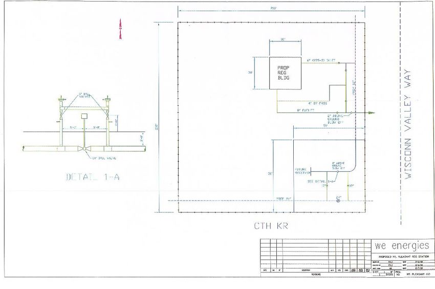
Lakeshore Capacity Enhancement Project                               Agricultural Impact Statement

         INTRODUCTION
The Wisconsin Department of Agriculture, Trade and Consumer Protection (DATCP) has prepared
this agricultural impact statement (AIS) in accordance with Wis. Stat. §32.035. The AIS is an
informational and advisory document that describes and analyzes the potential effects of the
project on farm operations and agricultural resources, but it cannot stop a project. The DATCP is
required to prepare an AIS when the actual or potential exercise of eminent domain powers
involves an acquisition of interest in more than five acres of land from any farm operation. The
term farm operation includes all owned and rented parcels of land, buildings, equipment,
livestock, and personnel used by an individual, partnership, or corporation under single
management to produce agricultural commodities.

The AIS reflects the general objectives of the DATCP in its recognition of the importance of
conserving important agricultural resources and maintaining a healthy rural economy. DATCP is
not involved in determining whether or not eminent domain powers will be used or the amount of
compensation to be paid for the acquisition of any property. As stated in Wis. Stat.
§32.035(4)(d):

       Waiting period. The condemnor may not negotiate with an owner or make a jurisdictional
       offer under this subchapter until 30 days after the impact statement is published.

The full text of Wis. Stat. §32.035, as well as additional references to statutes that govern
eminent domain and condemnation processes are included in Appendix B. Links to other sources
of information can be found in Appendix C.

The proposed project requires a Certificate of Authority (CA) from the Public Service Commission
of Wisconsin (PSC or Commission) before construction can begin. The PSC will analyze the need
for the project and the potential environmental and community impacts in an Environmental
Assessment. The Commission will approve, modify, or deny the utility’s application. Additional
information about this project and the PSC review process can be found on the PSC web site:
http://psc.wi.gov under the PSC docket number 6630-CG-137.

We Energies has developed an Agricultural Mitigation Plan (AMP) and Best Management Practices
(BMPs) for this project. The AMP and BMPs describe the policies to be followed and methods to
be used by We Energies to avoid or mitigate the potentially adverse impacts on agricultural
productivity from the construction of this pipeline. The AMP and BMPs are included in Appendix E
of this report.

During construction, We Energies may designate one or more individuals as the project
Agricultural Inspector. The Agricultural Inspector would be familiar with agricultural operations,
the AMP and BMPs, as well as gas pipeline construction.

Wisconsin Department of Agriculture, Trade and Consumer Protection                               4
Lakeshore Capacity Enhancement Project Agricultural Impact Statement We Energies anticipates acquiring easements in May 2018, prior to receiving approval from the Public Service Commission (PSC or Commission). Construction would start in October 2018, if it is approved by the Commission. The utility anticipates that the pipeline would be placed in service in November 2021. Wisconsin Department of Agriculture, Trade and Consumer Protection 5
Lakeshore Capacity Enhancement Project Agricultural Impact Statement
PROJECT DESCRIPTION
Overview
We Energies proposes to construct the following for the Lakeshore Capacity Improvement project
including the area within the Electronics and Information Technology Manufacturing (EITM)
zone):
Either 7.0 miles or 6.8 miles of 24-inch new steel natural gas pipeline through the
town of Yorkville and village of Mount Pleasant, depending on the Gate Station site
selected.
1.7 miles of 12-inch new steel natural gas pipeline within the EITM zone.
Two aboveground valve assemblies - one located within the EITM Zone and one
located at the eastern end of the pipeline, north of County Trunk Highway (CTH) KR
and along CTH Y (see Figure 4).
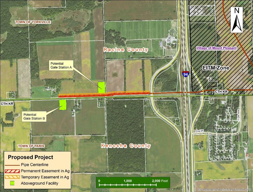
One Gate Station to be located at either Site A in the town of Yorkville, Racine County
or Site B within the town of Paris, Kenosha County (see Figure 2).
Figures 1 through 4 show maps of the proposed project.
Approximately 2.9 miles of the 24-inch pipeline, all of the 12-inch pipeline, and one of the
aboveground valve assembly facilities would be located within the EITM zone. No analysis is
included in this document for the portion of the project that would be located within the EITM
zone as impacts to properties within the EITM zone were analyzed in the, “Village of Mount
Pleasant, Foxconn Project AIS”, published on November 10, 2017 (DATCP #4229).
The aboveground valve assembly located at the eastern end of the project would require
approximately 100 feet x 100 feet of land. The gate station sites are located at the western end
of the project and the facility would require 200 x 200 feet of land and include a 30 x 30-foot
building. All aboveground facilities would be fenced.
The project route, from west to east, starts at either Gate Station A or Gate Station B. It then
extends along the north side of CTH KR crossing under Interstate (I)-94, through the EITM zone,
across CTH EA, a railroad, State Trunk Highway (STH) 31, and CTH M, until reaching CTH G. At
CTH G, the route turns north along the west side of Wood Road for approximately 1,000 feet and
then crosses to the east side of Wood Road. The route continues east again cross-country until
reaching CTH Y and the proposed site of the valve assembly facility.
Project Purpose and Need
The primary purpose of the Lakeshore Capacity Improvement project is to increase the capacity
and reliability of natural gas service in Racine, Kenosha and Milwaukee County areas.
Wisconsin Department of Agriculture, Trade and Consumer Protection 6Lakeshore Capacity Enhancement Project Agricultural Impact Statement Figure 1: Project Overview Map Wisconsin Department of Agriculture, Trade and Consumer Protection 7
Lakeshore Capacity Enhancement Project                               Agricultural Impact Statement

Figure 2: West End of the Proposed Project

Figure 3: Project Proposed East of the EITM Zone

Wisconsin Department of Agriculture, Trade and Consumer Protection                             8
Lakeshore Capacity Enhancement Project                               Agricultural Impact Statement

Figure 4: East End of the Proposed Project

ROW Requirements
The project would use current or future road right-of-way (ROW), wherever possible to minimize
impacts to private properties.

The natural gas pipeline trench would require a 50-foot wide permanent easement for much of
the route. Temporary construction easements with widths of either 25 or 50 feet would also be
required. The wider temporary easement in agricultural areas is necessary to accommodate the
storage of segregated excavated soils. The typical ROW width that could be disturbed by
construction activities would be between 75 and 100 feet.

The temporary easement would be restored and released when construction is completed.

The natural gas pipeline would be constructed in an open trench for much of the route, although
horizontal directional drilling (HDD) or jack and bore construction is proposed for crossing under
highways, railroads, and the Pike River. The use of boring construction avoids many of the

Wisconsin Department of Agriculture, Trade and Consumer Protection                              9
Lakeshore Capacity Enhancement Project                               Agricultural Impact Statement

impacts typically caused by trench construction. For the portions of the route that would be
directionally bored instead of open trench construction, narrower ROW widths would be required.

See Sections VII and VIII of this report for more information about potential construction
impacts.

Trench Dimensions
The excavated trench would be approximately 7 feet deep and 8 feet wide. In some areas where
there are obstacles, such as existing pipelines, the excavated trench may need to be deeper and
wider. In agricultural lands, trench depth will be sufficiently deep to allow a minimum of 4 feet of
soil cover over the top of the pipeline.

Service Connections
We Energies states that the proposed natural gas main will have distribution in the area to
provide service to all properties directly along the route.

Wisconsin Department of Agriculture, Trade and Consumer Protection                               10
Lakeshore Capacity Enhancement Project Agricultural Impact Statement
PROJECT IMPACTS TO AGRICULTURAL
PROPERTIES
Easements
The project could affect a maximum of 24 acres of agricultural land (not including the land within
the EITM zone) and 12 property owners. Two of the agricultural property owners (Elaine Sherry
and Zachary Schulz) would have land acquired by either the village, county, or the state prior to
the construction of this natural gas project.
Depending on the location of the gate station, between 18 and 21 acres of easement would be
required from agricultural property owners, including:
either 9.6 or 11.2 acres of permanent easements
either 6.7 or 8.3 acres of temporary easement
approximately 2.2 acres from one of two property owners for the gate station
0.2 acres required for a valve assembly.
No farm buildings or structures will be acquired for this project.
Of the easements required from farmland, most of the land is cropland (23.2 acres) with the
remainder used for other agriculture land uses. Most of the farmland is prime farmland.
Aboveground Facilities
If the project is approved, one gate station would be constructed on one of two sites at the west
end of the project and one aboveground valve assembly facility would be constructed at the east
end of the project. Both facilities would be constructed on private properties and would take
agricultural land out of production.
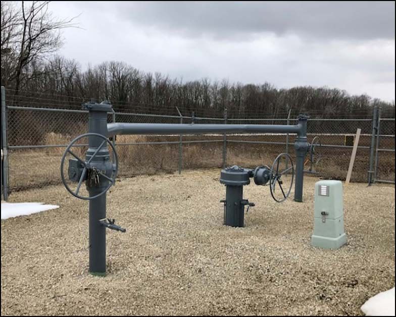
Figures 5 through 8 show typical images of gate stations and valve assembly facilities along with
a diagram of the proposed gate station. The aboveground facilities proposed for this project
would be surrounded by a fence as shown in Figure 5. The gate station would include a 30 x 30-
foot building (Figures 7 and 8).
The aboveground valve assembly facility would be a fenced area approximately 100 x 100 feet in
size. The facility would be located at the eastern end of an agricultural parcel owned by the
Bruce W & Vicki L Funk Trust, along CTH Y, in the village of Mount Pleasant. The field has been
used to grow soybeans for the past several years.
Wisconsin Department of Agriculture, Trade and Consumer Protection 11Lakeshore Capacity Enhancement Project Agricultural Impact Statement Figure 5: Typical Gate Surrounding Aboveground Facilities Figure 6: Typical Valve Assembly Facility Wisconsin Department of Agriculture, Trade and Consumer Protection 12
Lakeshore Capacity Enhancement Project                               Agricultural Impact Statement

Figure 7: Gate Station Diagram

Figure 8: Typical Building to be Located in the Gate Station

Wisconsin Department of Agriculture, Trade and Consumer Protection                             13
Lakeshore Capacity Enhancement Project                               Agricultural Impact Statement

The two potential gate station sites are Gate Station A and Gate Station B.

Gate Station Site A is located on the north side of CTH KR, in the town of Yorkville, Racine
County. Approximately 2.3 acres would be required from Daryl Poisl for the 200- x 200-foot
facility. The land is used to grow corn and soybeans.

Gate Station Site B is located on the south side of CTH KR, in the town of Paris, Kenosha County.
Approximately 2.1 acres would be required from Benjamin Coughlin and the Coughlin Trust for
the 200 x 200-foot facility. The gate station would be located within 200 feet of the Coughlin
residence and may be disruptive to his field operations. The land is used as cropland for corn
and soybeans.

The connection to Gate Station B site requires approximately 1,370 feet of additional gas
pipeline. The route proposed would require 3 acres of easements along the north side of CTH KR
on cropland owned by Daryl Poisl before crossing to the south side of CTH KR and connecting to
the gate station site on cropland owned by Mr. Coughlin.

We Energies has indicated that if Gate Station B is chosen by the PSC, the site could be moved
further east, potentially reducing the impacts to both the Poisl and Coughlin properties.
Additionally, the utility is seeking to purchase a larger parcel for the gate station site to
accommodate future pipeline facilities.

Based on the potential impacts of the gate station location, DATCP recommends that We Energies
work with Mr. Poisl and Mr. Coughlin so that impacts to both their farming operations from the
gate station and the pipeline are minimized to the extent practicable.

         AGRICULTURAL SETTING
The following information is intended to describe the existing agricultural sector of Racine County
in general terms and to aid agricultural property owners in their easement negotiations with the
utility. Section VI, Agricultural Landowner Impacts discusses the specific potential impacts from
this project and the concerns of agricultural property owners. The majority of the data provided
in this section was obtained from the USDA, National Agricultural Statistic Service.

Agricultural Productivity
Racine County had the thirteenth highest yield per acre for corn in 2016 among all of Wisconsin’s
72 counties, at 184.6 bushels per acre, while the statewide average yield was 178.0 bushels per
acre (USDA NASS Annual Wisconsin Agricultural Statistics Bulletin 2017). However, due to the
size of Racine County, its overall production of corn for grain was 34th in the state.

Table 1 shows the number of annually harvested selected crop acreages in Racine County from
2012 through 2016. Acreages for the crops listed are relatively consistent during this five-year

Wisconsin Department of Agriculture, Trade and Consumer Protection                               14
Lakeshore Capacity Enhancement Project Agricultural Impact Statement period. The low acreage of hay and silage harvested imply that the dairy sector is small in the county. Table 1: Acres of Selected Crops Harvested in Racine County Crop 2012 2013 2014 2015 2016 Corn for Grain 33,900 30,700 32,700 33,100 34,500 Corn for Silage NP NP 2,220 NP NP Soybeans 33,000 33,400 37,100 35,500 36,800 Winter Wheat 8,400 8,920 7,170 7,100 7,290 Alfalfa Hay 5,360 6,970 NA 6,370 5,630 * NA = data not published Land in Agriculture Racine County is classified as an urban county, which means it is a county with an average of more than 100 residents per square mile. The current population of the county is 195,146 residents. According to the 2012 Census of Agriculture, Racine County had 109,964 acres of land in farms or approximately 52 percent of the total land area. On average, 56 percent of urban counties are covered by farmland. Land in farms consists primarily of land used for crops, pasture, or grazing; however, it also includes woodland and undeveloped land not cropped or grazed, providing it is part of the overall farm operation. From 1997 to 2012, Racine County’s land in farms declined by 10.6 percent. In Wisconsin as a whole, the amount of land in farms declined by 2.2 percent. This shows that, on average, Racine County is losing farmland faster than the state as a whole, likely as a result of development. Table 2: Acres of Land in Farms Location 1997 2012 Racine County 123,012 109,964 Wisconsin 14,900,205 14,568,926 Number and Size of Farms Between 1997 and 2012, the number of farms increased by 3.8 percent in Racine County, and by 6.3 percent in Wisconsin as a whole (2012 Census of Agriculture). The average size of farms fell by 31 acres in Racine County and by 18 acres in Wisconsin from 1997 to 2012. Changes in the size of farms can indicate a change in commodities produced on those farms. Small farms tend to grow specialty and organic produce while larger farms tend to grow cash crops and raise large numbers of livestock. Wisconsin Department of Agriculture, Trade and Consumer Protection 15
Lakeshore Capacity Enhancement Project                                          Agricultural Impact Statement

Table 3: Number of Farms and the Average Size of Farms, 1997 and 2012
                                                 1997                                           2012
                                  Number of             Average Size of         Number of              Average Size of
 Location                           Farms                Farms (acres)            Farms                 Farms (acres)
 Racine County                       554                     222                   575                      191
 Wisconsin                           65,602                  227                   69,754                    209

Property Taxes and Values
Table 4 details the 2016 average property tax, assessed value, and sale price per acre of
agricultural land in Racine County, urban counties, and in Wisconsin. The assessed values and
property taxes are based on the use value of “agricultural land.” Agricultural land is defined by
statute as, “… land, exclusive of buildings and improvements, and the land necessary for their
location and convenience, that is devoted primarily to agricultural use.” (Wis. Stat. §
70.32(2)(c)1g)

In 2016, average property taxes on Racine County farmland were 2.0 percent higher than the
average for urban counties and 13.6 percent higher than the average for Wisconsin (Wisconsin
Department of Revenue). This higher than average tax rate may be one of the drivers causing
farmland owners to convert their property to non-farm uses in Racine County.

Table 4: Farmland Taxes and Values
                                                      2016 Dollars per Acre of Farmland
                                                                                              Sale Value for
 Location                            Average Tax               Assessed Value               Continued Ag Use
 Racine County                          $3.60                       $210                          $6,770
 Urban Counties                         $3.53                       $181                          $7,199
 Wisconsin                              $3.17                       $173                          $5,221
Source: USDA, National Agricultural Statistic Service and Wisconsin Department of Revenue.
* The assessed value is an “equalized value” calculated by DOR to correct for variability in estimating the taxable value
  of real property across municipalities.

The average assessed value of farmland in Racine County was 16.0 percent higher than the
average for urban counties and 21.4 percent higher than the average for Wisconsin as a whole
(Wisconsin Department of Revenue).

In Racine County, the average sale price of agricultural land was 6.0 percent lower than the
average for urban counties and 29.7 percent higher than the average for Wisconsin (NASS
Wisconsin 2017 Agricultural Statistics). These values do not include farmland sold and converted
to nonfarm use and do not include farmland with buildings or improvements. Additionally, these
values are from 2016 and may not accurately reflect the current market for farmland.

Wisconsin Department of Agriculture, Trade and Consumer Protection                                                       16
Lakeshore Capacity Enhancement Project Agricultural Impact Statement Farmland Preservation Wisconsin’s Farmland Preservation Program (FPP) provides counties, towns, and landowners with tools to aid in protecting agricultural land for continued agricultural use and to promote activities that support the larger agricultural economy. Through this program, counties adopt state- certified farmland preservation plans, which map areas identified as important for farmland preservation and agricultural development based upon reasonable criteria. The plans identify farmland preservation areas in the county, and local governments may choose to adopt an exclusive agricultural zoning ordinance to ensure that landowners covered by the ordinance are eligible to claim farmland preservation tax credits. Such an ordinance must also be certified by DATCP. The project area is not currently under exclusive agricultural zoning. Within these farmland preservation areas, local governments and owners of farmland can petition for designation by the state as an Agricultural Enterprise Area (AEA). This designation highlights the importance of the area for agriculture and further supports local farmland preservation and agricultural development goals. None of the land that could be impacted by this project is part of an AEA Conservation Reserve Program The Conservation Reserve Program (CRP) offers farmers financial incentives to convert highly erodible or environmentally sensitive cropland to permanent vegetative cover by planting species that will enhance the environment. None of the easements for this project appear to cross properties enrolled in the CRP. Conservation Reserve Enhancement Program The Conservation Reserve Enhancement Program (CREP) pays landowners to install filter strips along waterways or to return continually flooded fields to wetlands while leaving the remainder of the adjacent land in agricultural production. CREP is a joint effort between the federal, state, and county governments. DATCP is not aware that any land in the project area is enrolled in either the CRP or the CREP programs. Drainage Districts Drainage districts are formed to manage excess water on participating lands. The project does not cross any drainage districts. Wisconsin Department of Agriculture, Trade and Consumer Protection 17
Lakeshore Capacity Enhancement Project                               Agricultural Impact Statement

         FARMLAND SOILS

Farmland Soil Definitions
Farmland soil is classified by the USDA based on its ability to produce crops. Protecting prime
farmland, prime farmland, if drained, and farmland of statewide importance should be a priority
for construction projects.

Prime Farmland
Land that has the best combination of physical and chemical characteristics for producing food,
feed, forage, fiber, and oilseed crops and is also available for these uses. It has the soil quality,
growing season, and moisture supply needed to produce economically sustained high yields of
crops when treated and managed according to acceptable farming methods, including water
management. In general, prime farmlands have an adequate and dependable water supply from
precipitation or irrigation, a favorable temperature and growing season, acceptable acidity or
alkalinity, acceptable salt and sodium content, and few or no rocks. They are permeable to water
and air. Prime farmlands are not excessively erodible or saturated with water for a long period of
time, and they either do not flood frequently or are protected from flooding.

Prime Farmland if Drained
This farmland is prime farmland but requires draining in order to have the best combination of
physical and chemical characteristic for producing food, feed, forage, fiber, and oilseed crops.

Farmland of Statewide Importance
The criteria for defining and delineating this soil are to be determined by the appropriate state
agency or agencies. Generally, additional farmlands of statewide importance include those that
are nearly prime farmland and that economically produce high yields of crops when treated and
managed according to acceptable farming methods. Some may produce as high a yield as prime
farmlands if conditions are favorable. In some states, additional farmlands of statewide
importance may include tracts of land that have been designated for agriculture by state law.

Non-prime soils
Non-prime soils have limitations in terms of agricultural production and may be more susceptible
to damage from pipeline construction.

Farmland Soils Affected by the Proposed Project
If the project is approved by the PSC, the project could impact between 18 and 21 acres of
agricultural land, of which most is cropland. None of the land was identified as pasture or idle
farmland.

All of the agricultural cropland potentially affected by the project is either prime farmland
(7.94 acres) or prime farmland if drained (15.25 acres).

Wisconsin Department of Agriculture, Trade and Consumer Protection                                  18
Lakeshore Capacity Enhancement Project Agricultural Impact Statement A list of the agricultural soils that may be affected by the proposed project’s construction activities and are currently in crops is shown below in Table 5. Table 5: Agricultural Soils Potentially Affected by Project Soil Name Soil Classification Acres Ashkum silty clay loam, 0 to 2 % slopes Prime farmland if drained 5.71 Aztalan loam, 2 to 6 % slopes Prime farmland if drained 0.43 Beecher silt loam, 1 to 3 percent slopes Prime farmland if drained 2.60 Elliott silty clay loam, 2 to 6 percent slopes Prime farmland if drained 5.56 Markham silt loam, 2 to 6 percent slopes Prime farmland 1.47 Morley silt loam, 2 to 6 percent slopes Prime farmland 1.64 Morely silt loam, 2 to 6 percent slopes, eroded Prime farmland 2.89 Navan silt loam Prime farmland if drained 0.95 Symerton loam, 2 to 6 percent slopes Prime farmland 0.86 Varna silt loam, 2 to 6 percent slopes Prime farmland 1.08 Total 23.19 The majority of the soils crossed by the route are level, well-drained, silt loam soils. Three-Lift Soil Handling The three-lift soil handling procedure is recommended for cropland or pasture where the mixing of the subsoil layers may result in persistent crop yield reductions. For agricultural soils, the typical pipeline construction practice is to segregate the topsoil (typically the top 12 inches) from the remainder of the excavated subsoils. In contrast, the three-lift method requires the stockpiling of the topsoil, subsoil, and substratum in three separate piles. The last material removed from the trench is the first material backfilled into the trench. The three-lift soil handling method is useful when the proposed trench will intersect both the B and C horizons of a soil profile and the C horizon is significantly poorer in quality. For example, the three-lift method would be used if the C layer is gravel, rock, and/or sand, and the B layer is silt, clay, and/or loam. Additional factors such as slope, soil drainage, thickness of the soil horizons, and acres of soil units crossed by the project are important in determining soil candidates where the three-lift method would be useful in maintaining crop yields. A key for identifying soil candidates for three-lift is provided in Appendix D. We Energies’ best management practice for three-lift soil handling is included in Appendix E (BMP 09). Using the soil characteristics and descriptions compiled by the USDA, Natural Resources Conservation Service’s (NRCS) Web Soil Survey, a desktop review of the project area identified no soils that would potentially benefit from this type of soil management. Wisconsin Department of Agriculture, Trade and Consumer Protection 19
Lakeshore Capacity Enhancement Project                               Agricultural Impact Statement

         AGRICULTURAL LANDOWNER IMPACTS

DATCP Survey of Agricultural Property Owners
A summary of the property owners that could be affected and the associated acres of easement
required for this project is presented in Table 6. Additional non-agricultural acres would be
required and/or impacted for the construction of this project.

Table 6: Acres of Potentially Affected Farmland

                                              Permanent      Temporary      Permanent       Total
                                              Easement       Easement        Facilities   Easement
 Property Owner                                (acres)         (acres)        (acres)      (acres)
 Chiapete – Rossi 6 LLC R & P                                   0.20                        0.20
 Coughlin, Benjamin and Coughlin Trust                                         2.09          2.09
 Fink, Eugene                                     0.45           0.50                        0.95
 Fink, Eugene and Nancy L                         0.29                                       0.29
 Fink, Everett and Crystal A                      1.28           1.37                        2.65
 Funk Trust, Bruce and Vicki                      3.02           2.24          0.23          5.49
 Murphy, Michael A and Kathleen M                 1.35           0.34                        1.69
 Neu, Judith A and Lawrence P Ricchio             0.12                                       0.12
 Neu, Judith A and Neu et. al.                    0.23                                       0.23
 Poisl, Daryl                                     3.70           3.64          2.30          9.64
 Schulz, Zachary J and Mary M                     0.28                                       0.28
 Sherry, Elaine and Elsie Anderson
                                                  0.45                                       0.45
 Goulding
 Totals                                          11.17           8.29          4.62         24.08

DATCP attempted to contact by phone and letter all affected agricultural property owners who
could have easement acquisitions and/or impacts of two acres or more.

Owners of three properties responded with comments.

Property Owner Comments
Farmland Owner:             Benjamin Coughlin
Proposed Acquisition:       Potential Gate Station Site B: 2.1 acres

Mr. Coughlin grows cash crops on the property. The potentially impacted field has drain tiles in
the vicinity of the proposed project facilities. Mr. Coughlin stated that he is opposed to siting the
project on his property. He doesn’t think it makes sense to have the pipeline on the north side of
the road and then cross to the south side of CTH KR for the gate station. Furthermore, it would
be very inconvenient to farm around the gate station.

Wisconsin Department of Agriculture, Trade and Consumer Protection                                  20
Lakeshore Capacity Enhancement Project Agricultural Impact Statement Farmland Owner: Daryl Poisl Proposed Acquisition: Potential Gate Station Site A: 2.3 acres / Permanent Easement: 3.7 acres / Temporary Easement: 3.6 acres. Daryl Poisl owns 425 acres of land including 187 acres of cropland and 8 acres of pasture. He grows corn, soybeans, and hay. He also raises 30-head of beef cattle. The proposed project would cross along the southern edge of the Poisl fields, on the north side of CTH KR and is one of the potential sites for a gate station (Gate Station A). Mr. Poisl is concerned that the project will affect the drainage tiling and pasture fencing on his property. He is also concerned that the project will be placed close to his home. He would prefer to not have the pipeline on his property. Farmland Owner: Eugene and Nancy Fink Proposed Acquisition: Permanent Easement: 0.7 acres / Temporary Easement: 0.5 acres. In an effort to reach Everett Fink, DATCP staff spoke with his brother and wife, Eugene and Nancy Fink. Eugene and Nancy Fink farm land adjacent to the Everett Fink property and would also be affected by this project. Mr. and Mrs. Eugene Fink stated that in 2015, 20 tillable acres of their land was taken by the village. They described how roadway expansion and utility construction in support of the Foxconn development will require even more of their land. Mrs. Fink stated that she averages 15 hours per week defending what’s left of their property, making sure that all of their remaining land will have sewer, water and electrical service. This is necessary so their land can be sold in the next year or two for development as they don’t believe that agriculture in this area can stay viable as a business in the near future. AMP and BMPs and the Role of the Agricultural Inspector We Energies will employ a construction manager and an environmental manager to provide oversight and enforcement of permits, approvals, and the AMP and BMPs. We Energies may also retain one or more individuals designated as the project Agricultural Inspector. If retained, the Agricultural Inspector will be thoroughly familiar with the project and pipeline construction processes as well as issues regarding agricultural operations and soil conservation. DATCP recommends that the project have at least one individual designated as the Agricultural Inspector for this project during construction and that he/she share periodic reports with DATCP for review. Contractors will be required to structure their construction activities to be consistent with the AMP and the BMPs. Refer to Appendix E for the full text of these documents. We Energies will work with landowners to ascertain existing agricultural operations that may require special attention during construction and restoration. Topics that are covered by the AMP and BMPs include restoration of any damaged conservation practices, tiling, and fences. Appraisal and Compensation The acquisition of easements by utilities with eminent domain authority in Wisconsin is stipulated under Wis. Stat. § 32.06. Additional information about the appraisal process and landowners Wisconsin Department of Agriculture, Trade and Consumer Protection 21
Lakeshore Capacity Enhancement Project Agricultural Impact Statement
rights can be found in a Wisconsin Department of Administration publication, “The Rights of
Landowners under Wisconsin Eminent Domain Law,” at the website:
http://doa.wi.gov/Documents/DEHCR/Relocation/WI_Eminent_Domain_Law32_06.pdf
We Energies may conduct a market study to determine current area property values of affected
property. If the landowner signs an appraisal waiver form, the market study will be the basis for
the utility’s offer of compensation and no individual property appraisal will be conducted. We
Energies may also offer additional compensation to landowners who choose to sign the appraisal
waiver form.
Landowners have the right to obtain an appraisal of their property under Wisconsin’s eminent
domain laws (Wis. Stat. §32.06). A jurisdictional offer will include an appraisal of the fair market
value for the easement and any anticipated damages to the property. The fair market value
means the price that a willing buyer would pay to a willing seller in the market. This will be
based on at least one full narrative appraisal for each property the utility intends to acquire. The
appraisal must be presented to the landowner.
Additionally, landowners have the right to obtain their own appraisal of their property. They will
be compensated for the cost of this appraisal by the utility if the following conditions are met:
The appraisal must be submitted to the utility or its designated real estate contractor
within 60 days after the landowner receives the initial utility appraisal.
The appraisal fee must be reasonable.
The appraisal must be a full, narrative appraisal
The appraisal must be completed by a qualified appraiser.
The amount of compensation for the easement is established during the negotiation process
between the utility and the individual landowner. Landowners may also attempt to negotiate
additional stipulations from the utility and additional payments.
The utility is required to provide landowners with information about their rights in this process
before negotiations begin. Wis. Stat. § 32.035(4)(d) additionally requires that the utility not
negotiate with a landowner or make a jurisdictional offer until 30 days after the AIS is published.
More information about the appraisal process and landowners rights can be found on the DOA
website at: http://doa.wi.gov/Divisions/Energy-Housing-and-Community-Resources/Relocation-
Assistance.
Landowners should keep in mind that any easement they sign with a utility is an individual
contract. The easement contract is binding to the landowner and any future owners of the land,
until the contract is dissolved. When considering whether or not to sign an easement,
landowners should examine the language carefully and verify that it contains all agreed-to terms.
Landowners should be familiar with the company’s project-specific AMP and BMPs (Appendix E)
so as to determine if additional conditions should be negotiated with the utility. Though they can
Wisconsin Department of Agriculture, Trade and Consumer Protection 22Lakeshore Capacity Enhancement Project Agricultural Impact Statement choose to waive any or all of the practices and procedures described in the AMP and BMPs, DATCP recommends to only do so with careful consideration. Landowners may want to seek legal advice if they have any questions about this process, and should make sure that any attorneys hired have expertise and experience in eminent domain law and procedures. More reference information can be found in Appendix B. Wisconsin Department of Agriculture, Trade and Consumer Protection 23
Lakeshore Capacity Enhancement Project                               Agricultural Impact Statement

         CONSTRUCTION PROCESS
If the project is approved by the PSC, construction on the gas pipeline will likely begin after the
utility has secured all necessary permits and ROW easements. Typical natural gas pipeline
construction sequence proceeds in the manner of an outdoor assembly line; comprised of specific
activities that make up the linear construction sequence. These operations include surveying and
staking the ROW, clearing and grubbing (digging up roots and stumps), grading, pipe stringing,
welding and bending, trenching, lowering-in, backfilling, re-grading, cleanup, hydrostatic testing,
and restoration (Figure 4). While most of this project would use open trench construction,
horizontal directional drilling (HDD) will be used in some locations to avoid impacts to features
such as roads, driveways, and natural resources.

Typical construction equipment used on pipeline projects includes: dozers, graders, excavators,
trenchers, dump trucks, backhoes, side booms, ATV’s, road bore rigs, horizontal directional drill
rigs, pickup trucks, rock trenchers, vacuum excavators, rippers, tillers, rock picking machines,
welding rigs and trucks, and x-ray trucks.

Surveying and Staking
The first construction step involves surveying and staking the pipeline centerline, construction
ROW limits, temporary workspace areas, and known underground facilities that cross or parallel
the proposed pipeline. Construction activities and equipment travel requires the use of
temporary work space in addition to the permanent easement.

Access roads to the pipeline ROW are typically along existing ROWs such as public roads and
farm roads. Additional temporary access roads may be necessary, and some of these may cross
agricultural lands. Temporary work space needed for access roads on private lands will be
negotiated with the landowner. Construction of these roads will follow practices detailed in the
utility’s AMP and BMPs including where appropriate, soil segregation, proper maintenance of
existing surface drainage patterns, and restoration of the land. If the property owner approves,
access roads will be left in place.

Clearing, Grubbing, and Grading
The construction ROW (easement and areas secured for temporary work space) is cleared,
grubbed, and graded to provide a level area for pipe-laying operations and the transport of
construction equipment. Clearing involves the removal of all trees and brush from the work area.
Grubbing, the removal of stumps and roots, occurs over the area where the trench will be
excavated. Non-woody vegetation is removed by mowing. However, crops such as small grains
with a limited amount of biomass may be left in place to minimize soil erosion. A fence crew
operates with the clearing crew to cut and brace existing fencing and install temporary gates
along the ROW. This crew also installs necessary fencing along identified sensitive areas as
required by agencies and along pastures that contain livestock.

Wisconsin Department of Agriculture, Trade and Consumer Protection                                  24
Lakeshore Capacity Enhancement Project Agricultural Impact Statement Figure 9: Typical Pipeline Construction Cross-Section on Agricultural Land Source: We Energies Wisconsin Department of Agriculture, Trade and Consumer Protection 25
Lakeshore Capacity Enhancement Project                               Agricultural Impact Statement

The utility will work with affected landowners when the cutting of merchantable timber on their
property is necessary for construction of the pipeline. Timber may be cut and left along the edge
of the ROW for the landowner’s use. If the landowner does not want to retain ownership of the
material, it will be properly disposed. The disposal of trees, brush, and stumps may include
burning, burying, or chipping at a landowner-approved location or removal to another authorized
location.

Vegetation from wild black cherry and black walnut trees can be toxic to livestock. All debris
from these trees are to be removed from actively pastured areas to prevent its contact with
livestock. This material will not be stockpiled on-site.

The utility strips the topsoil (typically the top 12 inches) from the full width of the ROW in
agricultural areas. The topsoil is stockpiled along the edge of the easement to minimize damage
to the productivity of the topsoil. In some locations, maintaining pre-construction soil
productivity requires that the subsoil be segregated not only from the topsoil but also from the
underlying parent material. This is known as three-lift soil managing.

Erosion control methods and materials vary depending on the specific construction activities, time
of year, and site soil and slope conditions at the time of construction. A general description of
construction phases will be outlined in the utility’s Erosion Control Plan and the project-specific
AMP and BMPs. These documents include details about clearing and grubbing (digging up roots
and stumps), pipe and associated facility installation, and restoration.

Pipe Stringing
After clearing, grubbing, and grading, sections of pipe are transported by truck from pipe storage
areas to the construction ROW and positioned along the pipeline route. This is called pipe
stringing. Pipe stringing can be conducted either before or after trenching.

Bending and Welding
After pipe stringing, the sections of pipe are bent, as necessary, to fit the contours of the terrain.
The pipe is then placed on temporary supports along the edge of the trench, aligned, and welded
together. A qualified inspector visually and radiographically inspects the completed welds.
Following inspection, a coating is field-applied to each weld joint. An external coating, applied at
the mill protects the rest of the pipe. This pre-applied coating is also inspected and repaired as
necessary.

Trenching
Open trenching is the primary method for new gas pipeline construction. Alternatively, in some
locations, the utility will use HDD to avoid impacts to features such as roads, driveways, and
natural resources. HDD is discussed in more detail later in this section. Trenches are typically
excavated using a backhoe, or in some cases a trackhoe, or a trenching machine. Topsoil and

Wisconsin Department of Agriculture, Trade and Consumer Protection                                    26
You can also read