Airborne VNIR-SWIR hyperspectral remote sensing for environmental urban mapping - Patrick LAUNEAU, Zeineb KASSOUK* (UMR 6112 LPGNantes, OSUNA) ...

Page created by Sidney Sanders
 
CONTINUE READING
Airborne VNIR-SWIR hyperspectral remote sensing for environmental urban mapping - Patrick LAUNEAU, Zeineb KASSOUK* (UMR 6112 LPGNantes, OSUNA) ...
Airborne VNIR-SWIR
    hyperspectral remote sensing
      for environmental urban
              mapping
Patrick LAUNEAU, Zeineb KASSOUK* (UMR 6112 LPGNantes, OSUNA)
               Patrice MESTAYER (FR 2488 IRSTV)
                        and collaborators
                                             * VegDUD post-doc (ANR-09-VILL-0007-01)
Airborne VNIR-SWIR hyperspectral remote sensing for environmental urban mapping - Patrick LAUNEAU, Zeineb KASSOUK* (UMR 6112 LPGNantes, OSUNA) ...
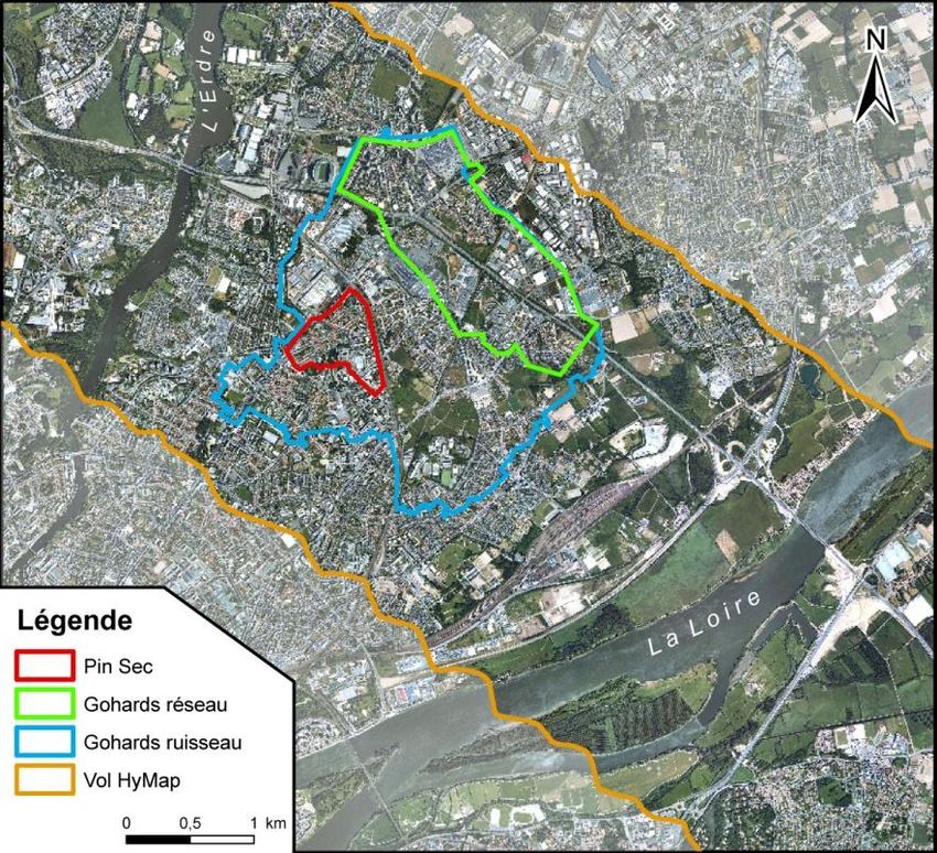
Where does we come from?
Airborne VNIR-SWIR hyperspectral remote sensing for environmental urban mapping - Patrick LAUNEAU, Zeineb KASSOUK* (UMR 6112 LPGNantes, OSUNA) ...
Planetology !
Laboratoire de Planétologie et Géodynamique de Nantes UMR-CNRS 6112
Airborne VNIR-SWIR hyperspectral remote sensing for environmental urban mapping - Patrick LAUNEAU, Zeineb KASSOUK* (UMR 6112 LPGNantes, OSUNA) ...
Hyperspectral data are
intensively used for mapping
planetary surfaces
Airborne VNIR-SWIR hyperspectral remote sensing for environmental urban mapping - Patrick LAUNEAU, Zeineb KASSOUK* (UMR 6112 LPGNantes, OSUNA) ...
Hyperspectral data are
                                              intensively used for mapping
                                              planetary surfaces

                                              and tested on Earth
                                              in desert area

HyMap airborne image
showing peridotite alteration in serpentine
and its weathering in carbonates
Airborne VNIR-SWIR hyperspectral remote sensing for environmental urban mapping - Patrick LAUNEAU, Zeineb KASSOUK* (UMR 6112 LPGNantes, OSUNA) ...
Why are we looking at urban environments?
Airborne VNIR-SWIR hyperspectral remote sensing for environmental urban mapping - Patrick LAUNEAU, Zeineb KASSOUK* (UMR 6112 LPGNantes, OSUNA) ...
SOERE Environnement Urbain
Le système d’observation et d’expérimentation URBIS
     A network of 3 observatories for urban
     environments in Nantes, Paris and Lyon

                               Recognition as SO INSU SIC in 2012
Airborne VNIR-SWIR hyperspectral remote sensing for environmental urban mapping - Patrick LAUNEAU, Zeineb KASSOUK* (UMR 6112 LPGNantes, OSUNA) ...
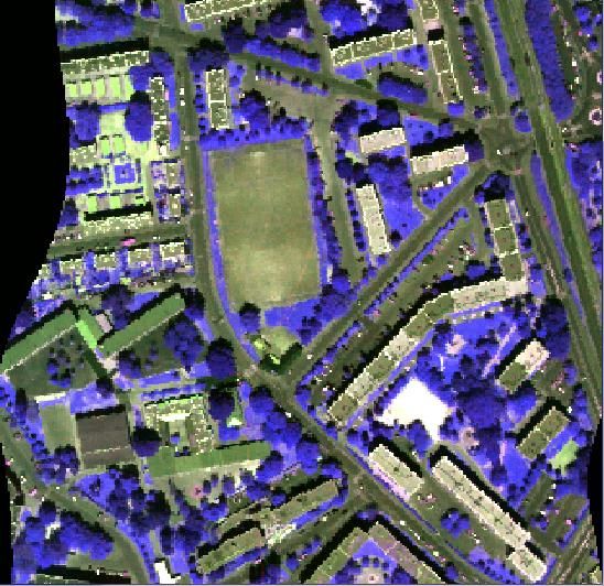
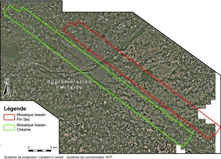
The observatory for urban environments in Nantes

   I – Urban Hydrosystems
   - 1 : Pin-Sec & Gohards watershed                                                       2                    1
   - 2 : Chézine watershed
   - 3 : Nantes-Centre (local water quality)
                                                                                                            3
       Mainly supported by
FEDER = ERDF: European Regional Development Fund

         CPER 2007-2013 GÉNIE CIVIL,
         ENVIRONNEMENT ET GESTION
         DURABLE DE LA VILLE

                                                   Chronique des mesures pluviométriques et débimétriques
                                                   journalières (Gohards - 2000)                                    SPOT 96

                               Meigeville (regional fund)
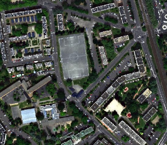
Airborne VNIR-SWIR hyperspectral remote sensing for environmental urban mapping - Patrick LAUNEAU, Zeineb KASSOUK* (UMR 6112 LPGNantes, OSUNA) ...
Meigeville

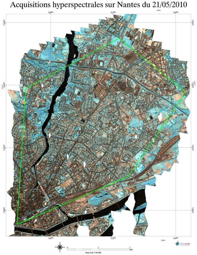
First airborne campaign in august 2008
-DLR (German Aerospace Centre)
- 2008 July 22 at 10h00 UTM

-126 channels
- spectral range:               0.45 – 2.48 µm
- spectral resolution:          15 to 20 nm
- spatial resolution:           4m
- atmospheric correction : Atcor 4

HyMap :
 - Pin Sec : 152 km²
 - Chézine : 184 km²
                                                                                        HyMap

                  Cessna 208B                                 flight altitude: 1930 m
Airborne VNIR-SWIR hyperspectral remote sensing for environmental urban mapping - Patrick LAUNEAU, Zeineb KASSOUK* (UMR 6112 LPGNantes, OSUNA) ...
First constitution of a spectral library (2008)

                                  roads                            parking lots                 sidewalks                       concretes
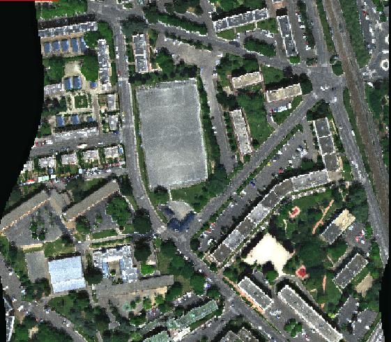
                                                                                            Tiles
Color composite image
     HyMap (4 m)
                        gravel sport fields             synthetic sport fields                    roofs                    street painting

                                                                                                       lawns               deciduous trees

                                  metal                          wooden path

                             Spectral angle maping of urban materials
                                                                                                                 ASD FieldSpec 3
      Cadastre

                                                                                                      Régis Roy post-doc 2008

                                               Gravel   roofs
                                               Gravier toiture
                                                                                                      Barrel tiles
                                                                                                 Tuile (tige de botte)

                                                                                              Tuile                Tuile
                                          Parking                Route            New interlocking
                                                                                           mécanique              Old interlocking
                                                                                                                 Mécanique
                        Parking lot asphalts                     Road asphalts
                                                                                         roofneuve
                                                                                              tiles               roof
                                                                                                                   usée tiles
2008      2009

CPER 2007-2013 GÉNIE CIVIL,
ENVIRONNEMENT ET GESTION
DURABLE DE LA VILLE
Axe 3 : l’application de la
télédétection au génie civil
environnemental et à la gestion
durable de la ville

                                         Airborne
Second and third airborne campaigns in 2010 and 2011
Operator :
 - Actimar
Hyspex VNIR: 160 channels
spectral range: 400 - 1000 nm
spatial resolution: 0.6 m
spectral resolution: 4 nm
Hyspex SWIR: 256 channels
spectral range : 1000 nm - 2500 nm
spatial resolution : 1.2 m
                                                        HySpex (LPGN)
spectral resolution : 6 nm
                                                       Ans IMU(Actimar)
Atmospheric correction : Atcor 4 (Actimar)
Campaign 1 (Meigeville program)                            Campaign 2 (ANR VegDUD)
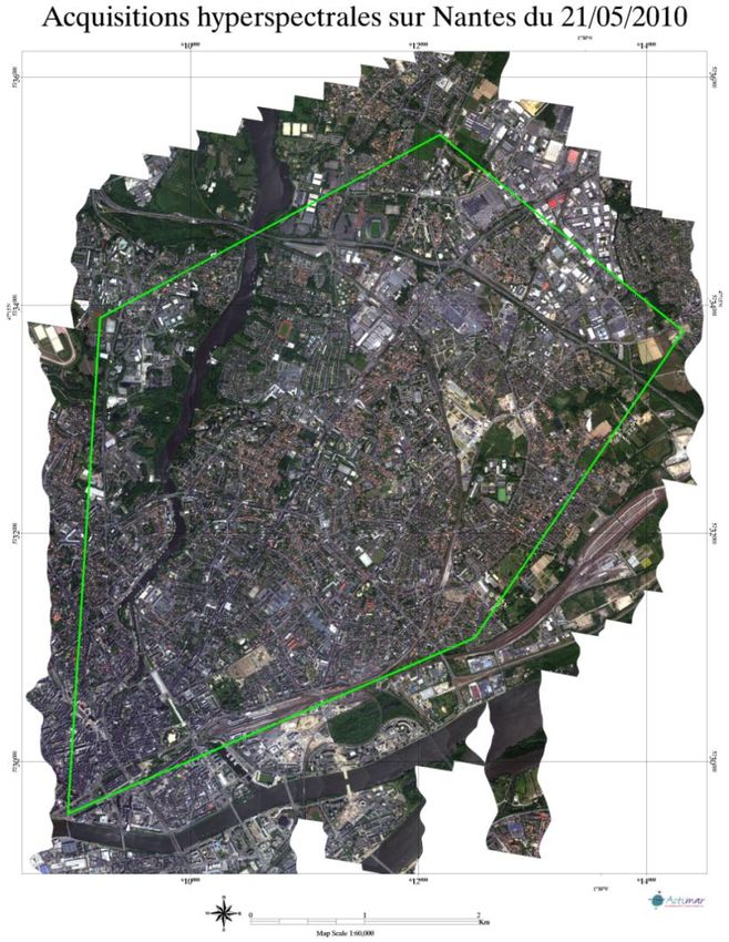
20 flight lines in 2010 May 21                             2011 September 15,16 and 28
                                                           22 flight lines with difficult weather conditions

                                             Example of 1 flight line
640 nm
                                            1640 nm

560 nm   460 nm                   1250 nm        1040nm

                  Mosaic of the 2010 flight lines
Data fusion at the lower spatial resolution

Image VNIR (0.4 – 1µm) (0.6m)      Image SWIR (1- 2.5 µm) (1.2m)   Image VNIR-SWIR (0.4- 2.5 µm) (1.2m)

             VNIR    SWIR

                                                                                    VNIR+SWIR
Focus the analysis on vegetation types

VegDUD Project (ANR-09-VILL-0007-01)                                    NDVI

   We can use indices (combination of 2 or 3
   channels measuring a spectral curvature)

   Or

   We can use spectral angle mapping
   (measuring the angle between two vectors
   of 160 dimensions (HySpex channels))

                Field
    Channel 2

                                Image

                        Channel 1
Focus the analysis on vegetation types

 Bi-Directionnal Reflectance Distribution (BRDF)                        no direct comparison between lab and field data

                 This can be avoided by:
                 1) Using homogenous subsets of pixels constituting meaningful
                    objects delineating trees or any vegetation patch
                 2) Sampling data in the image like for a remote sensing classical
                    training

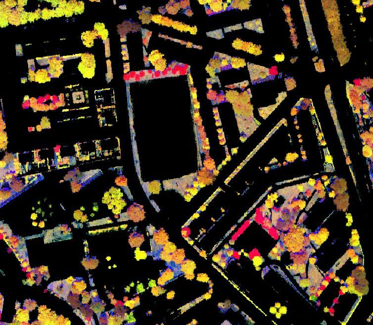
1: LAI : Indice foliaire = surface foliaire/ unité de surface terrain
Image segmentation in objects
                                           SAM angle of one vegetation type                SAM index of one vegetation type

The segmentation of the image in objects is done with
eCognition (Definiens software).

But instead of using directly the hyperspectral image,
we use a compilation of indices and SAM results to
feed the software and better delineates the tree
borders.

                                                                              Color composite image of 3 SAM indices
Object statistics

          Pixel classification

                                     Object stat

         Object classification

Example of G2 super-class (Quercus palustris, Acer negundo and Catalpa bignonoides)

                                                                                  Training sample

                                                                                      Object
Spectral training library for object classification

                                    Training spectra of 13 vegetation super-classes
                                       (group of vegetation spectrally identical)

                     6000
                                                                                                     Spectra of vegetation super-classes with
                                       G1                                                            species grouped according to their SAM
                                       G2                                                            index similarity.
                     5000
                                       G3                                                            G1: Fraxinus exelsior, Betula verrucosa,
                                       G4                                                            Quercus robur;
                                       G5
                                                                                                     G2: Quercus palustris, Acer negundo,
                                       G6
                     4000                                                                            Catalpa bignonoides;
Refleftance(100*%)

                                       G7
                                       G8                                                             G3: Salix babylonica, Lonicera nitida,
                                       G9                                                            Platanus occidentalis;
                     3000              G10                                                           G4: Liquidambar styraciflua, Quercus
                                       G11                                                           coccinea;
                                       G12                                                           G5: Prunus cerasifera, Acer rubra;
                                       G13
                     2000                                                                            G6: Pinus radiate, Pinus pinea;
                                                                                                     G7: Cedrus atlantica;
                                                                                                     G8: Pinus sylvestris, Cupressus arizonica;
                     1000
                                                                                                     G9: lawn;
                                                                                                     G10: degraded lawn;
                                                                                                     G11: shaded lawn;
                       0
                       0.4   0.45      0.5    0.55   0.6    0.65    0.7   0.75    0.8   0.85   0.9
                                                                                                     G12: Sedum;
                                                      Wavelength (µm)
                                                                                                     G13-G14: other plants.
Object classification

      Ü                                                 Spectra of vegetation super-classes with
                                                        species grouped according to their SAM
                                                        index similarity.
                                                        G1: Fraxinus exelsior, Betula verrucosa,
                                                        Quercus robur;
                                                        G2: Quercus palustris, Acer negundo,
                                                        Catalpa bignonoides;
                                                         G3: Salix babylonica, Lonicera nitida,
                                                        Platanus occidentalis;
                                                        G4: Liquidambar styraciflua, Quercus
                                                        coccinea;
                                                        G5: Prunus cerasifera, Acer rubra;
                                                        G6: Pinus radiate, Pinus pinea;
                                                        G7: Cedrus atlantica;
                                                        G8: Pinus sylvestris, Cupressus arizonica;
                                                        G9: lawn;
                                                        G10: degraded lawn;
                                                        G11: shaded lawn;
                                                        G12: Sedum;
                                                        G13-G14: other plants (unknown).

G 1   G 6   G 9      G 12            0     100 Meters
G 2   G 7   G 10     G 13
G 3   G 8   G 11     G 14
G 4
G 5
What about space-borne Earth hyperspectral observation?
HYPXIM
HYPER SPECTRAL IMAGERIE A HAUTE RESOLUTION & GRAND CHAMP

    Véronique CARRERE (LPGNantes, Univ. de Nantes)
       Coordinatrice du Groupe Mission Sciences (PI)

                   PK1 HYPXIM 26/03/2010
CONTEXTE de la Mission

     •    A l’étude depuis 2009 (Phase 0) – Passage en Phase A après Revue de Mission
         (11 Juin 2012) pour un lancement éventuel en 2018-2020 (?)

     •   Positionnement dans le contexte spatial français et international :

     -   Saut technologique / précurseurs : Hyperion, USA; HJ-1A/HSI, 2008, Chine; HySI/IMS-1,
         2008, Inde;
     et missions programmées : PRISMA, 2013?, Italie; EnMAP, 2015, Allemagne;
     ou en pré-phase A : HyspIRI, USA; AToMS/NASA Venture Proposal, USA; HISUI, Japon;…

     -   Mission duale : doit satisfaire à la fois les besoins Défense et les besoins scientifiques
         civils (grande gamme d’applications)

     - Participation de 2 industriels en parallèle durant la Phase 0 : T.A.S. et ASTRIUM
     -> 2 projets d’instruments performants

23
                                  Véronique CARRERE – PI Science
SPECIFICATIONS

•         Spécifications instrumentales retenues en fin de Phase 0 :
- Gamme spectrale = [400-2500 nm], couverture continue (+ capteur panchromatique)

+ Hydrosphère (neige, glace) à ajouter

-        Plate forme « agile » (revisite) + ralenti pour meilleur SNR

•         Capteur Infrarouge thermique envisagé pour une deuxième génération (?)

    24
                                          Véronique CARRERE – PI Science
You can also read