Mobile Mapping Sees It All - Trimble Geospatial
←
→
Page content transcription
If your browser does not render page correctly, please read the page content below

CUSTOMER EXPERIENCE I JULY 2021

Mobile Mapping
Sees It All

Charlotte Water adopted innovative technology to save time and money locating its 300,000 water meters.

How mobile mapping and artificial
intelligence (AI) combine to identify
                                                                                          Solution
and map water meters                                                                    Trimble® MX7 Mobile Mapping System
                                                                                        Trimble Business Center
360-degree street-level imagery supports                                                Applanix® POSPac MMS™ Software
automated object detection in a fraction of                                             Applanix POS LV
the time

TRANSFORMING THE WAY THE WORLD WORKS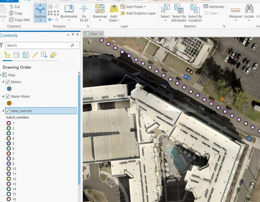
overview
North Carolina’s Charlotte Water
turned to Trimble and Esri for help
creating an innovative mapping
solution to verify the locations of its
revenue-generating water meters.
                                                                                                Location
By integrating the precision detail of                                                    NORTH CAROLINA
Trimble’s MX7 mobile mapping system                                                             US

with Esri’s artificial intelligence (AI)
algorithms, the agency developed a
system that automatically detects each
meter and maps its exact location.
The new approach is providing a cost-
effective, repeatable alternative to
manual verification.

The City of Charlotte operates the largest water/                that algorithms could be trained to identify water meters
wastewater utility in the Carolinas and serves around one        and the approach is scalable for a city-wide program;
million customers. However, only 30 percent of nearly            however, the image accuracy was inadequate for delivering
300,000 water meters throughout Charlotte Water’s                precise location information.
service area have verified locations. Several sources of
information have been used in the past to establish meter        Esri provided a comparison of potential mobile mapping
sites, including as-builts, Google Street View, aerial imagery   systems that are better suited for comprehensive, high-
and surveys. These approaches were primarily manual and          accuracy image collection. After evaluating the pros and
costly—the City spent around $400,000 to locate meters           cons, Charlotte Water decided to move forward on a large-
in 2019.                                                         scale effort using a Trimble MX7 mobile mapping system.

In search of a better process, the City of Charlotte sought      “The GoPro could be as much as 30 feet off and the front-
help from consultants in the Esri Advantage Program, who         facing camera was often blocked by on-street parking,
suggested an AI solution that could detect water meters in       pedestrians, and mailboxes,” said Shannon Martel, GIS
high-resolution imagery. To test the viability of the concept,   Manager, Charlotte Water. “Trimble was our top choice
Charlotte Water first collected 200 images with a GoPro          because we really needed the 360-degree high-resolution
camera and applied Esri’s algorithms. The results showed         coverage, combined with the integrated GPS accuracy.”

  TRANSFORMING THE WAY THE WORLD WORKS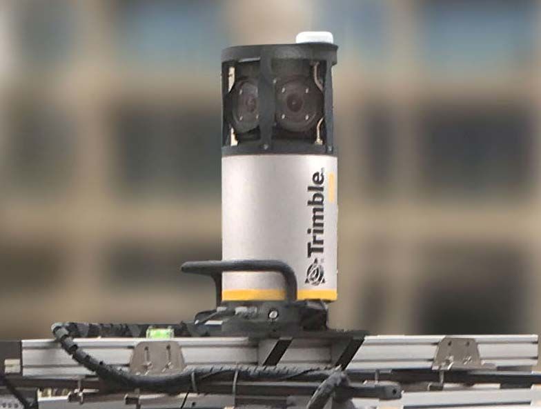
Charlotte Water uses Esri ArcGIS Pro to map and display meter locations with other GIS layers.

COMPLETE AND ACCURATE
INFORMATION

The vehicle-mounted Trimble MX7 mobile mapping system
offers several advantages for Charlotte Water’s high-
volume data capture needs. The synchronized navigation
sensors and imaging sensors are designed to collect
georeferenced images at highway driving speeds for
maximum productivity. In addition, driving routes can be
imported into the Trimble software to guide the operators
and increase their efficiency.

The built-in GNSS and inertial technology, along with
the optional Applanix POS LV, delivers precise location
information. The navigation data is downloaded and                          The Trimble MX7 collects 360-degree images and IMU/GNSS data
                                                                            from a moving platform.
processed using Applanix POSPac MMS and Trimble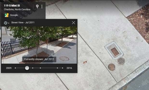
Business Center software to obtain spatial accuracy of
2 to 10 inches. The MX7 has six cameras for 360-degree
collection, which is helpful for seeing around obstacles,
and the 30-megapixel (MP) resolution shows fine detail
in every image.

“From the perspective of artificial intelligence—
specifically the photogrammetry—the combination
of accurate GPS information linked to each image, as
well as the ability to easily collect images from different
angles simultaneously, are key to the success of this type
of analysis,” said Dr. Wendy Keyes, Esri Data Scientist.

The AI portion of the solution integrates open-source
tools with Esri ArcGIS Pro. Charlotte Water uses Esri
ArcGIS Pro to map and display multiple GIS layers, such
as parcel boundaries and streets, along with the lat/long
coordinates of the water meters generated by the model.
With the object identification handled automatically,
human workers can focus on maintaining the City’s
assets and maximizing its resources.

“The price point and performance of the MX7 was just
what we needed, and we hope to repeat the meter data
collection every 1 to 2 years to keep our database current,”
said Martel. “Other departments are exploring using the
MX7 images to manage assets like fire hydrants and street
signs, which further improves our return on investment.”                                                                    The AI algorithms are trained on images representing seven
                                                                                                                            different types of water meters.

“The Trimble MX7 mobile mapping system will allow us to accurately
map all 300,000 water meters in 2 to 3 years, compared to 8 to 10
years using manual methods. Up-to-date location information is vital for
reducing our maintenance costs and enhancing our customer service.”
                                                                                     —Shannon Martel, GIS Manager, Charlotte Water

                                                                                                                    NORTH AMERICA          EUROPE                  ASIA-PACIFIC
                                                                                                                    Trimble Inc.           Trimble Germany GmbH    Trimble Navigation
                                                                                                                    10368 Westmoor Drive   Am Prime Parc 11        Singapore PTE Limited
                                                                                                                    Westminster CO 80021   65479 Raunheim          3 HarbourFront Place
                                                                                                                    USA                    GERMANY                 #13-02 HarbourFront Tower Two
                                                                                                                                           +49-6142-2100-0 Phone   Singapore 099254
                                                                                                                                           +49-6142-2100-140 Fax   SINGAPORE
  Contact your local Trimble Authorized Distribution Partner for more information                                                                                  +65-6871-5878 Phone
                                                                                                                                                                   +65-6871-5879 Fax
© 2021, Trimble Inc. All rights reserved. Trimble, the Globe & Triangle logo and SiteVision are trademarks of
Trimble Inc., registered in the United States and in other countries. Android is a registered trademark of Google
LLC. All other trademarks are the property of their respective owners. PN 022516-6181 (07/21)

TRANSFORMING THE WAY THE WORLD WORKS
You can also read