AN INTEGRATED APPROACH TO TRANSIT SYSTEM EVOLUTION - A Knowledge Synthesis Grants project co-funded by the Social Sciences and Humanities Research ...
←
→
Page content transcription
If your browser does not render page correctly, please read the page content below

AN INTEGRATED
Research Report                       APPROACH TO
                                      TRANSIT
                                      SYSTEM
                                      EVOLUTION

A Knowledge Synthesis Grants project co-funded by the
Social Sciences and Humanities Research Council and
Infrastructure Canada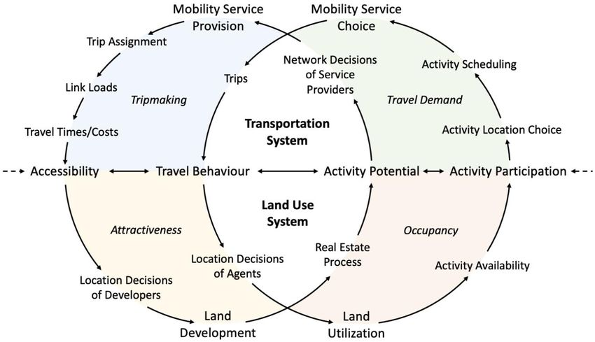
An Integrated Approach to
Transit System Evolution
University of Toronto
Transportation Research Institute

December 2021

Christopher D. Higgins
University of Toronto
Scarborough
cd.higgins@utoronto.ca

Steven Farber            Amer Shalaby            Khandker Nurul          Eric J. Miller
University of Toronto    University of Toronto   Habib                   University of Toronto
Scarborough                                      University of Toronto

Shauna Brail             Michael J. Widener      Sara Diamond            Antonio Páez
University of Toronto    University of Toronto   OCAD University         McMaster University
Mississauga

Billy Zhang              Yixue Zhang             Matt Palm               Ignacio Tiznado-
University of Toronto    University of Toronto   University of Toronto   Aitken
                                                                         University of Toronto

Project Administration
Judy Farvolden           Patricia Doherty
University of Toronto    University of Toronto
Transportation           Transportation
Research Institute       Research Institute

Workshop Assistants
Robert Arku              Spencer McNee           Saeed Shakib            Fernanda Soares
University of Toronto    University of Toronto   University of Toronto   University of Toronto

Anton Yu
University of Toronto
EXECUTIVE SUMMARY
About the Project
Recent transformational trends are changing the way we think about transportation and land use
interaction in cities. On the one hand, technological innovations appear to be promoting rapid and
potentially disruptive changes in transportation infrastructure and services. This includes the rise of new
electric mobility modes and mobility service providers offering ride-hailing, carpooling, bikesharing, and
other means of transportation. Looking ahead, connected and autonomous vehicles and highly integrated
Mobility-as-a-Service (MaaS) platforms also stand to reshape how we travel. On the other hand, the
global COVID-19 pandemic is also impacting the way we think about transportation and land use. Early
evidence suggests the pandemic has dramatically altered travel behaviour and settlement patterns in
many communities.
This knowledge synthesis project provides an up-to-date perspective on the transportation-land use
system and the role of public transit within it. To do so, we first revisit the core works that inform the ways
in which we think about the transportation-land use connection in cities. Second, we review recent
literature on new transportation technologies and trends associated with the COVID-19 pandemic with a
focus on how they have changed, and may potentially change, the transportation-land use connection.
Third, we complete the synthesis of previous works through a reinterpretation of the transportation-land
use connection through the lens of new technology to provide a conceptual basis for more integrated
systems planning. In addition to the review activities, the project benefits from the co-creation of
knowledge facilitated through three workshops with public, private, and not-for-profit sector stakeholders.
Key Findings
Compared to previous research into the transportation-land use connection, our reinterpreted system is
rooted in an activity-based approach, generalizes the transportation system around mobility services, and
incorporates new thinking on the links between transportation accessibility, travel behaviour, activity
potential, and activity participation. We use the reinterpreted system to answer several thematic questions
it considering the changes that have, and are likely to occur, over the
next decade in Canadian communities.
First, can public transit alone affect land use change? Probably not but the combination of transit service
that offers accessibility benefits relative to other travel options with supportive planning and policy can
create a compelling development context for realizing land use change.
Second, is there a role for land value capture for financing transit? Probably while transit can create
land value uplift, there are challenges associated with implementing large-area value capture strategies
related to the timing, spatial extent, sources, and amount of uplift that can be captured. Still, smaller-
scale joint development projects have the potential to offset some project costs.
Third, can we balance the transport and land use benefits from transit with social outcomes? We should
try land value uplift from transit can result in the least advantaged residents in society paying
proportionately more of their income to live near transit or being displaced to areas where transit is less
competitive. However, policy supports for affordable housing in new and established station areas,
business stabilization plans, and community benefits agreements for transit projects can help in this
regard.
Fourth, will new mobility technologies and trends lead to more suburbanization? Possibly autonomous
vehicles may contribute to suburbanization by decreasing transportation costs associated with more
regional travel patterns. On the other hand, micromobility modes and services might help to urbanize the
suburbs by better connecting individuals and households to more local destinations and improving
first/last-mile connections to transit.
iFifth, do we need to rethink future planning for sustainability? Perhaps information communication
technologies, work-from-home and social distancing policies, and new transportation technologies can
lead to more decentralization and driving. Nevertheless, face-to-face communication will continue to be
an important driver of agglomeration in many sectors and as traffic congestion returns, mass transit and
active modes will maintain their competitive advantage for moving people. Cities are also about more
than work, and greater emphasis can be placed on planning to improve local accessibility.
Policy Implications
The review has revealed that we -land use interaction and the need for
an integrated approach to achieve improved social, economic, and environmental outcomes. However,
several barriers prevent major changes from occurring, including a largely private sector-driven land
development process, a culture of automobility, fractured planning responsibilities, insufficient knowledge
mobilization, and a lack of visioning and political will.
Nevertheless, we can use leverage points to intervene in the transportation-land use system and achieve
meaningful improvements in system performance. These include treating all new greenfield development
sites as an opportunity for master-planned complete communities, identifying suburban contexts with
strong opportunities for urbanization such as shopping centres and arterial commercial strips, intensifying
underutilized lands, using infrastructure interventions and computational approaches to improve transit
performance and relative accessibility, and experimenting with mobility services and MaaS platforms to
improve accessibility and transport equity in urban and suburban areas.
Such initiatives must be undertaken while recognizing feedbacks within the larger regional transport-land
use system and pursued in partnership with developers and the public so that individual costs and
benefits are balanced with a better understanding of improvements to society and the public good.
Further Information
For further information, please contact:
Christopher D. Higgins
Assistant Professor, Department of Human Geography
University of Toronto Scarborough
cd.higgins@utoronto.ca
iiTABLE OF CONTENTS
INTRODUCTION ........................................................................................................................................................ 1
METHODOLOGY ....................................................................................................................................................... 1
KNOWLEDGE MOBILIZATION ACTIVITIES ............................................................................................................ 2
PART 1. REVISITING THE TRANSPORTATION-LAND USE CONNECTION ........................................................ 3
THE TRANSPORTATION-LAND USE CONNECTION ........................................................................................................ 3
URBAN ECONOMIC FOUNDATIONS: TRANSPORTATION COSTS AND SPATIAL STRUCTURE ............................................. 4
Spatial Equilibrium ............................................................................................................................................. 6
Agglomeration .................................................................................................................................................... 6
Transportation Technologies ............................................................................................................................. 6
Government Policy............................................................................................................................................. 7
TRANSPORTATION-LAND USE CONNECTION IN PRACTICE ........................................................................................... 7
Transportation Costs and Decentralization ....................................................................................................... 7
Transportation Costs and (Re)Centralization .................................................................................................... 8
Transportation, Land Use, and Travel Behaviour .............................................................................................. 9
Integrated Transportation and Land Use Policy: Planning for TOD ................................................................ 11
Planning for Accessibility ................................................................................................................................. 14
BEYOND THE TRANSPORTATION-LAND USE CONNECTION......................................................................................... 15
PART 2. NEW TECHNOLOGIES, TRENDS AND THE TRANSPORT-LAND USE SYSTEM ............................... 18
NEW TRANSPORTATION TECHNOLOGIES .................................................................................................................. 18
Physical Networks............................................................................................................................................ 18
Physical Modes ................................................................................................................................................ 18
Mobility Services .............................................................................................................................................. 20
Mobility-as-a-Service ....................................................................................................................................... 23
Digital Infrastructure and ICTs ......................................................................................................................... 25
THE COVID-19 PANDEMIC ..................................................................................................................................... 25
Initial Impacts ................................................................................................................................................... 26
The Post-COVID Recovery .............................................................................................................................. 27
PART 3. REINTERPRETING TRANSPORT AND LAND USE FOR FUTURE INTEGRATED SYSTEMS
PLANNING ............................................................................................................................................................... 29
REINTERPRETING THE TRANSPORTATION-LAND USE CONNECTION ........................................................................... 29
THEMATIC CONCLUSIONS ........................................................................................................................................ 31
1. Can public transit alone affect land use change? ........................................................................................ 31
2. Is there a role for land value capture? ......................................................................................................... 32
3. Can we balance the transport and land use benefits from transit with social outcomes? .......................... 34
4. Will new mobility technologies and trends lead to more suburbanization? ................................................. 35
5. Do we need to rethink future planning for sustainability? ............................................................................ 36
PART 4. TOWARDS FUTURE INTEGRATED SYSTEMS PLANNING ................................................................. 39
CHALLENGES: SYSTEM CONTEXT ............................................................................................................................ 39
OPPORTUNITIES: SYSTEMS AND LEVERAGE ............................................................................................................. 40
REFERENCES ......................................................................................................................................................... 42
APPENDIX 1. WORKSHOP ATTENDEES.............................................................................................................. 53INTRODUCTION
Transport systems have a significant impact on the efficiency, equity, sustainability, resiliency, and health
of communities in Canada and around the world. We rely on transport systems to move people between
locations where they carry out their daily activities. They also provide firms with access to labour markets,
goods movement, and enable both the intensification and outward growth of cities. As such, the transport
system is fundamentally intertwined with the use of land. For public transit, research has shown that it
performs best when closely integrated with land use planning. This makes understanding the role of
public transit in the wider transport-land use system of great importance for guiding effective policy and
planning at all levels of government.
While there is a consensus around the relationship between transit and land use, recent transformational
trends are changing the way we think about transportation and land use integration. On the one hand,
new technologies are producing opportunities to make transportation systems more flexible, seamless,
accessible, and affordable. On the other, technological change can be disruptive, leading to changes in
transport mode usage and presenting challenges for multimodal and multi-ownership (public and private)
system integration. Similarly, other trends may produce structural changes that affect preferences for
particular modes or alter travel patterns, such as the ongoing COVID-19 pandemic. Within an
interconnected system like transport, such changes can have ripple effects that alter outcomes ranging
from land use planning and real estate markets to affordable housing and equitable access.
Considering these factors, an integrated approach is required for governments and transit agencies to
conceptualize, manage, and plan transport systems over the next several decades. To that end, the
proposed project reviews and synthesizes knowledge around several key questions: What are the
theoretical foundations of how transportation shapes land use (and vice-versa)? What is the current state
of knowledge on transportation and land use interaction? How are new technologies affecting modal shift
and multimodal integration? What does the evidence show about the benefits that arise from synergies
between transportation and land use? How have these synergies affected property markets and the
potential for land value capture, as well as impacts on housing and social equity? How have travel
patterns changed due to new technologies and the recent COVID-19 pandemic?
Although there have been academic debates over the strength and directionality of relationships in the
transport-land use system in the past, an up-to-date perspective on this system through the lens of new
transportation technologies does not yet exist. In response, this project revisits core theories, reviews
recent research, and reinterprets the transportation-land use relationship in light of the challenges and
opportunities that have occurred and are likely to occur over the next decade in Canadian communities.
The objectives of this synthesis are to first assess the state of knowledge about the transportation-land
use connection, identifying research strengths and gaps. Second, the project team evaluates the quality,
accuracy, and rigour of the reviewed works. Third, we use the results of the synthesis as a foundation for
mobilizing the perspectives and expertise of academics and stakeholders in government and the private
and not-for-profit sectors on the role of public transit in Canadian communities in the future. In doing so,
this work fills a critical gap in our knowledge regarding the role of public transit in the face of new and
potentially disruptive changes to the transportation system.
METHODOLOGY
Literature reviews in the field of transportation have been criticized for often lacking specificity and rigour
in their methods (van Wee & Banister, 2016). To overcome this, the present work organizes its review
and synthesis around three research modules: revisiting the transportation-land use connection,
reviewing recent literature regarding new technologies and trends, and reinterpreting the transport-land
use relationship for integrated systems planning. For the first module, we engaged in a targeted review
of major works by drawing on the knowledge bases of team members to select relevant works. Where
appropriate, this list was expanded to include information on new methods, techniques and debates. This
synthesis is presented in Part 1 of the report.
1The second module adopted a much wider approach to reviewing the literature on new transportation
technologies and trends. The review activities were organized around key concepts relevant to each
theme. For new transportation technologies, we utilized Google Scholar to search for papers focused on
keywords such as autonomous vehicles, ridehailing, micromobility, on-demand transit, and information-
communication technologies. For new trends, we focused on research relating to the COVID-19
keywords such as mode and location choices, remote
work, and face-to-face communication. When they were available, we utilized findings from existing
-land use system narrative.
To fill in remaining gaps or update some reviews, research papers were only selected for review if they
focused on transportation and/or land use issues. Moreover, due to the deluge of substandard research
associated with the pandemic (Bramstedt, 2020), we placed significant emphasis on papers published in
major high-quality peer-reviewed journals. Grey literature is also used to contextualize some information
where appropriate. Finally, Part 3 of this research engages in a value-added synthesis consisting of a
critical appraisal of results and the formulation of forward-looking conclusions.
KNOWLEDGE MOBILIZATION ACTIVITIES
To mobilize knowledge in this project, we engaged in three workshops with stakeholders from the public,
private, not-for-profit, and academic sectors. Each workshop was planned around the three major themes
of the project: 1. Revisiting the Transportation-Land Use Connection, 2. Reviewing New Technologies,
Trends and the Transport-Land Use System, and 3. Reinterpreting Transport and Land Use for Future
Integrated Systems Planning. All together we welcomed 64 unique attendees from 23 different entities
(Appendix 1) across all three workshops with 39, 36, and 23 attending workshops 1, 2, and 3 respectively.
Workshops 1-2 began with the dissemination of findings obtained from the review and synthesis activities
outlined within the individual modules. Following this, we shifted to a collaborative forum where
participants engaged with the material through roundtable discussion sessions led by project team
members that were oriented to topical questions. Finally, report-back activities summarized the key points
raised in the roundtables, enabling the co-creation of synthesized knowledge that was instrumental in
shaping the outcomes of this project. Workshop 3 adopted a similar structure, but rather than a roundtable
discussion, we summarized the major findings of the synthesis and hosted an open plenary discussion
about the challenges and opportunities associated with realizing integrated systems planning in the
Canadian context.
2PART 1. REVISITING THE TRANSPORTATION-LAND USE CONNECTION
The first objective of this research synthesis is to revisit the core theories and methodological frameworks
that inform the way we think about transportation and land use as an integrated system. Decades of
research suggest that changes in transportation networks influence the location choices of households
and firms and patterns of development. Likewise, land use patterns influence the design of the
transportation network (including its modal composition and level of service) and impact the number and
type of trips made on it. This relationship is known as the transportation-land use connection and it rests
on core works that cover a variety of topics.
The Transportation-Land Use Connection
Transportation and land use exist within an integrated system (Figure 1). This makes it particularly difficult
to examine one aspect in isolation of the other. At a high level, Giuliano (2004) discusses the
characteristics of the urban system where transportation infrastructure reduces travel impedance or the
transportation costs associated with the friction of distance and improves accessibility to destinations.
This accessibility impacts the location of land uses and the activities they contain. The combination of
transport accessibility and land uses affects travel patterns and manifests as flows on the network.
Giuliano notes that although this model details the interdependencies between transportation and land
use and how changes in one aspect affect the others, it does not imply anything about the strength of
these relationships.
Figure 1. The Transportation-Land Use Connection
Source: Bertolini (2012)
Other researchers have offered versions of the urban system graph. Bertolini (2012) graphic shown in
Figure 1 offers more detail on the factors that affect different aspects of the urban system, including the
role of technological innovations, infrastructure investments, and policy choices on the development of
transportation networks, factors influencing the land development process, and the socioeconomic,
demographic, and cultural factors that influence the availability of activities. Bertolini also includes some
indications of the temporal dynamics involved in system change. In contrast, (1996) version
shown in Figure 2 is more oriented to travel behaviour and locational decisions within a more static
transportation system. The report will draw on both examples in proposing a reinterpreted transportation-
land use system in Part 3.
3Figure 2. Land Use Transport Feedback Cycle
Source: Wegener (1996)
A key concept within this framework is transportation accessibility. As summarized by Geurs & Van Wee
-use activity can be reached from a location using a particular transport
- -Akiva &
-use and
transport systems enable individuals to reach activities or destinations by means of a trans
Whichever definition one adopts, a key determinant of accessibility is the friction or cost associated with
travel. Such travel costs are typically measured in terms of distance, time, or money, and accessibility
measures capture the elements of spatial or spatio-temporal proximity through the travel costs associated
with travel on the transportation network and the attractiveness of opportunities available at destinations
reachable from the origin. While accessibility measurement and accessibility planning constitute an active
area of scholarship that we cover in more detail further below, the concept of accessibility is essential to
more general urban economic models of the city that underpin our understanding of why cities exist, how
they develop, and how they are shaped by transportation technologies and integrated planning.
Urban Economic Foundations: Transportation Costs and Spatial Structure
In traditional urban economic models of the city, urban forms and functions are fundamentally shaped by
accessibility, which is often framed in terms of transportation costs and transportation technologies
(Glaeser & Kohlhase, 2003). Early firm location models from Christaller (1933), Lösch (1944), and Isard
(1956) assume that the primary force shaping economic decisions is the cost of moving goods over
space. Similarly, transportation costs are key aspects of the foundational models of urban economics.
This includes the monocentric city models of Alonso (1964), Muth (1969), and Mills (1972), hereafter
referred to as the AMM model, where urban land uses and development intensity are a function of
transportation costs (see Box 1 below). Per Glaeser and Kohlhase (2003), transportation technologies
are implicit in the AMM model with transportation costs consistent with cities built around walking and
transit for moving people to the central business district.
These models capture the essence of historical urban forms and economies at the turn of the 20th century
when transportation costs were high. While the friction of distance has fallen dramatically over the past
century, transportation costs and technologies still shape cities with respect to four concepts from urban
economics that underpin our understanding of the relationship between transportation and land use in
cities: spatial or locational equilibrium, agglomeration economies, transportation technologies, and
government policy (Glaeser, 2008).
4Box 1. The Standard Urban Model
The spatial equilibrium model of Alonso (1964), extended by Muth (1969), and Mills (1972), seeks to explain
the patterns of urban land use. Miron (1982) and Brueckner (1987) offer summaries of the fundamental
aspects of these models. The theory is built on a foundation of spatial equilibrium and land uses are
determined in a competitive land market where a parcel is allocated to the highest bidder. The use of a
particular parcel is thus a function of willingness to pay amongst business, industrial, residential, and
agricultural uses. All parcels in a city have site advantages in terms of the internal characteristics of the site
such as its ease of development, and locational advantages such as accessibility to markets, labour pools,
or proximity to major transportation facilities. Firms consider their normal profit, or the profit that is required
long-term to maintain the business, and excess profit above and beyond the required normal profits. For
commercial and industrial uses, firms bid up the price of land at different sites to the point at which their
excess profits reach zero, and the site is ultimately allocated to the highest bidder. This highest bidder is
the firm whose excess profits at that parcel would be maximized due to the match between their business
and the site and locational advantages of the parcel.
Box Figure 1. Hypothetical Monocentric and Polycentric Urban Structures
Figure from Clark (2000), a: adapted from Bourne (1981); b: adapted from Cadwallader (1996). Reproduced
with permission from Wiley-Blackwell.
On the household side, households consume land, measured in terms of lot size or living area, and other
goods such as food and clothing. The purchase of land and other goods is assumed to generate a level of
utility or satisfaction. Households also spend some proportion of their income on commuting to jobs in the
central business district. Like firms, households compete for land and will bid up prices where the attainable
utility level is high. Assuming the price of goods is constant across the city, for a particular group of
households with the same utility level and income, the price bid for a given location is a trade-off between
living area and commuting costs. This trade-off emerges, in part, from residential developers maximizing
their profits in accessible locations by building more densely. In suburban areas, this leads to housing that
5is lower in cost per square metre of living space and larger homes on bigger lots. However, commuting
costs absorb a larger part of the household budget and less is spent on other goods and services. In more
urban settings, greater accessibility leads to lower commuting costs and more income spent on goods and
services, but these commuting savings are offset by a higher per square metre cost of housing and smaller
homes. With transportation costs a key component of the model, the result is an urban form with different
uses competing for locations high in accessibility and higher density uses on more expensive land (Box
Figure 1 Panel A).
The Alonso-Muth-Mills model can be criticized along several dimensions. Perhaps the biggest criticism is
that the monocentric assumption of the model is at odds with a world in which cities are increasingly
polycentric and major employment centres are located far away from the old central business district (e.g.
Giuliano and Small (1991)). In response, researchers have extended the Alonso-Muth-Mills model to
include more than one employment node (Box Figure 1 Panel B) and the prediction is that in cities that are
more decentralized, the relationship between distance from employment nodes and housing prices is flatter
(Fujita & Ogawa, 1982; Glaeser, 2008; Henderson & Mitra, 1996). Other criticism includes its simplified
views of urban land markets, a reliance on spatial equilibrium, and assumptions of utility-maximizing
behaviour (Miron, 1982), as well as its ignorance of the urban transportation system and treatment of
housing based on a single attribute (Brueckner, 1987). However, despite its limitations, the Alonso-Muth-
Mills model maintains a great deal of attraction. According to Glaeser (2007)
its ability to make predictions that hold generally, not in its ability to explain the exact peculiarities of
particular places.
Spatial Equilibrium
First, the concept of spatial or locational equilibrium is that all locations around a city offer an equivalent
level of utility given their prices. Prices adjust to achieve locational equilibrium for people and firms and
as a result, no entity has an incentive to change locations. While spatial equilibrium is never quite
achieved in constantly changing cities, this simplifying assumption provides a foundation on which the
other aspects of the urban economic models of cities are built. In practice, the concept of spatial
equilibrium relates to trade-offs that occur when selecting a location. This could mean a household trading
off between living in a costly apartment in the urban core that offers shorter travel times to a variety of
destinations reachable by transit, bicycle, or foot, or a larger house in a suburban area that requires
longer travel times to reach amenities. In both scenarios, the utility the household derives from living at
either location is assumed to be equal.
Agglomeration
Second, agglomeration economies exist whenever individuals and firms become more productive
through proximity to one another. The centripetal forces of agglomeration economies arise due to
centrality, or that the nature of the city as a place of closeness negates much of the friction of distance
for transporting goods and information, which in turn facilitates lower costs and higher productivity.
However, transportation costs in terms of the physical movement of goods have less of a role in creating
and maintaining agglomeration economies in modern cities. Innovations in transportation technologies,
which will be discussed further below, have reduced the importance of traditional transport hubs such as
ports or railroads. But while agglomerations based on transport costs for goods have all but disappeared,
Glaeser (2008) notes that agglomeration based on reducing the transport costs of people and ideas
remains (and indeed has to high-
value business services and innovation where face-to-face contact still matters. This need for face-to-
face contact, alongside transportation costs for people movement, still acts as a centripetal force for
higher density development.
Transportation Technologies
Third, transportation technologies have had a fundamental impact on the shape and character of cities
for as long as cities have existed. For example, the shape of the monocentric city is largely a function of
pre-20th century transportation technologies, with both New York and Chicago growing around their ports
and later their rail hubs. When moving goods by sea or rail was more cost-effective than road, proximity
6to sea or rail terminals offered a locational advantage for firms to be more productive. However,
innovations in transportation technologies over much of the 20 th century, such as trucks and cars, led to
dramatic declines in the cost of shipping goods and moving people (Glaeser & Kohlhase, 2003). Glaeser
and Kahn (2003) argue that the dominance of the automobile over other modes was essentially complete
by the turn of the century. Per the Alonso-Muth-Mills model, this reduction in transportation costs should
result in an erosion of the agglomerative properties of the monocentric city with lower transportation costs
causing the spatial extent of the city to expand and densities to fall. Indeed, this reduction in transportation
costs has been cited as one of the key drivers of the dispersion of households and firms into suburban
areas throughout the second half of the 20 th century (Glaeser & Kahn, 2003; Handy, 2005).
Government Policy
Fourth, government policy can have a profound effect on shaping growth in cities. This can come through
enabling transportation technologies and the construction of transportation infrastructure. For example,
Baum-Snow (2007) notes the case of federal highway construction in the United States and its role in
facilitating the dispersion of people and jobs to sprawling suburban areas. Land use planning is just as
important as one of the primary tools governments use to shape how, where, and when growth occurs
(Glaeser, 2008). Other government policies have also been identified as factors contributing to urban
decentralization and locational dispersion in the United States, including subsidies for highways and
sprawl (Glaeser & Kohlhase, 2003), market failures regarding the social benefits of open space, the true
cost of infrastructure required to service suburban developments, and the social costs associated with
commuting behaviour (Brueckner, 2001), as well as zoning controls that prohibit intensification in cities
and push development to the urban fringe (Glaeser & Kahn, 2003).
Transportation-Land Use Connection in Practice
While these models provide general insight into why cities exist and the characteristics that influence
their spatial structure, researchers have long questioned the strength and mechanisms of the
transportation-land use connection in shaping urban form, travel behaviour, and other social, economic,
and environmental outcomes. This section provides an overview of major debates in the field and the
current state of knowledge regarding different elements of the transportation-land use connection
depicted in Figure 1.
Transportation Costs and Decentralization
The 1990s and early 2000s saw increased debate around the strength of the transportation-land use
connection. While urban economic models noted the strong role of transportation costs in shaping cities,
these models tend to be crafted under the assumption of high costs for the movement of people and
goods associated with travel primarily by rail and by foot. However, the 20th century saw a dramatic
decline in transportation costs due to the invention, miniaturization, and widespread adoption of the
engine to power cars and trucks. For industry, these reduced absolute costs combined with a shift to
high-value goods production has meant that firms are not likely to place a significant value on
transportation costs when selecting a location, with Glaeser and Kohlhase (2003, p. 199) stating
better to assume that moving goods is essentially costless than to assume that moving goods is an
In addition to reducing movement costs, Glaeser and
Kahn (2003) note how cars and trucks eliminate the scale economies associated with the fixed costs of
older transportation technologies like rail and shipping, further reducing the agglomeration benefits of
locating around terminals.
In line with what the AMM model would predict, reductions in transportation costs are associated with
urban spatial expansion and sprawl. Brueckner (2000) argues that in addition to falling transportation
costs, excessive spatial expansion in the United States also results from population growth driving
demand for development and rising incomes causing households to demand more living space and
bigger dwelling sizes (see additional discussion related to demographics further below). This combines
with three market failures to drive suburbanization: a failure to take into account the social value of open
space, a failure to recognize the social costs of congestion, and the failure of the development process
to account for the public infrastructure costs generated by peripheral development projects and making
7development artificially cheap. To this Glaeser and Kahn (2003) add environmental externalities like air
pollution and greenhouse gas emissions from driving and note the role of zoning in restricting new
housing supply in built-up areas and driving decentralization in many cities.
This reduction in transportation costs and the underperformance of large investments in urban rail transit
in the 1970s and 1980s (e.g. Cervero and Landis (1997)) led researchers to question how strong a role
transportation costs play in contemporary locational decisions and the ability of transit to shape cities.
Guiliano (1995) argues there is overwhelming evidence that public transit projects alone are not an
efficient means for affecting land use patterns within this context. Reasons for this include modern
metropolitan areas having well-developed transportation systems so that even large investments in new
infrastructure will only have an incremental effect on accessibility, the durability of the built environment,
and that transportation costs are so low that transportation considerations are of declining importance in
the locational decisions of households and firms.
Transportation Costs and (Re)Centralization
Although much of the narrative about cities in the late 20th century was regarding urban sprawl, the turn
of the 21st century saw the reversal of urban flight and disinvestment in several cities across the United
States. This process has been referred to as the -to-the- (Sturtevant & Jung, 2011),
(Fishman, 2005) (Ehrenhalt, 2012), amongst other names
(see Hyra (2014)). This section discusses some of the forces related to transportation costs informing
centripetal growth in cities, including traffic congestion and the importance of face-to-face contact in the
knowledge economy.
First, while the decline in transportation costs over the 20 th century has had a decentralizing effect on
cities, the personal automobile and the urban form associated with it can also act as a contradictory force
for centralization and intensification. The ascendancy of the automobile is based on time savings and
flexibility. However, by impacting the monetary, as well as the travel time (duration and variance),
physical, and mental costs of transportation, congestion can increase transportation costs and reshape
the form of cities. Part of this relates to the concept of constant travel time budgets that imply an upper
b - as
delay causes individuals to make alternative travel mode and locational choices (Metz, 2021). As the
costs of moving people and goods by automobiles and trucks increase, both firms and individuals may
again find an economic advantage in density and agglomeration. There is some evidence that traffic-
related increases in transportation costs are affecting the locational decisions of individuals and acting
as a centripetal force for urban growth. Ehrenhalt (2012) offers the example of Atlanta, where the most
frequently cited reason for moving away from suburban areas to the central city amongst the middle-
class is traffic.
The second factor affecting contemporary urbanization is agglomeration benefits that arise from face-to-
face contact in the post-industrial city. At their most basic, cities are density or the absence of physical
space between people and firms that minimizes the friction of distance in the movement of people, goods,
and ideas (Glaeser & Gottlieb, 2009). As discussed above, innovations in transportation technologies
have eroded the benefits of agglomeration for people and goods movement, although congestion remains
an important cost. Likewise, observers such as Friedman (2007) have argued that innovations in
information communication technologies (ICTs) such as e-mail, mobile phones, and the internet have
lowered barriers to communicating ideas over space, leading some to as
a factor impeding the transmission of information (Cairncross, 1997). In this sense, it is not that the costs
of physical transportation will continue to fall, but rather that ICTs will cause activities to become
n to become redundant, and agglomeration economies to disappear
(Rietveld & Vickerman, 2004).
But despite the proliferation of ICTs, it appears that cities still offer agglomeration advantages based on
the exchange of ideas or tacit knowledge. At a higher level, several authors have depicted a new
geography of employment in the knowledge, creativity, and innovation sectors, driven by high levels of
8human capital and with workers drawn to cities rich in urban amenities (e.g. Florida (2002), Glaeser and
Kolko (2001), Moretti (2012), Storper and Scott (2009)). The notion that cities exist to expedite the flow
of ideas and create knowledge spillovers that facilitate innovation has long been recognized (Jacobs,
1969). At a smaller scale, the success of firms engaged in the innovation economy depends both on
human capital and proximity, resulting in what Glaeser (2011, p. 6)
s become ever more valuable
even as the cost of transporting goods, people, and information over long distances has fallen.
Part of this stems from differences in how the different types of knowledge used in the process of
innovation are shared. Based on the work of Polanyi (1966), a distinction is made between explicit
knowledge (or codified knowledge) and tacit knowledge (or scientific knowledge). Explicit knowledge is
more formal and can be transmitted in systematic language and has a singular meaning and
interpretation. In contrast, tacit knowledge
(Audretsch, 1998, p. 21) According to Gertler (2003, p. 89)
-
that it defies conscious articulation meaning that (i) we may not even be aware of it, or the way it
influences our behaviour, and (ii) even if we are, when we try to articulate or explain it to someone else,
communicating this knowledge in verbal, written, or diagrammatic form will never be fully equal to the
task. For these reasons, tacit knowledge must be learned by demonstration, imitation, performance, and
As a consequence, the sharing of tacit knowledge is highly dependent on spatial proximity and face-to-
face communication and, in contrast with codified knowledge, does not lend itself to easy communication
via ICTs. Similarly, Rietveld and Vickerman (2004) argue that face-to-face contact will remain important
for fostering trust between parties. With trust being a foundation of many types of social and commercial
interactions, this will result in significant distance decay effects on the dispersion of particular activities.
Extending this within the framework of the AMM model, the costs involved in the transmission of tacit
knowledge and building relationships through shared trust should act as a force for agglomeration in
contemporary cities.
Transportation, Land Use, and Travel Behaviour
Researchers have long been interested in whether, and to what extent, different aspects of the
transportation-land use connection influence travel behaviour and the social, environmental, and
economic outcomes associated with how people travel in cities. This research area considers the left-
hand side of the transportation-land use connection depicted in Figure 1, where the transportation system
and land use combine to influence the activity and travel patterns of individuals. However, emphasis in
this section is on transportation or land use initiatives in isolation.
On the transportation network side of this relationship, evidence has shown that increases in
transportation mobility can have a profound, but complex effect on the transportation-land use system.
On the one hand, as detailed above, new transportation infrastructure such as a new highway can
increase mobility, reduce travel times, and spur more decentralized patterns of growth and development.
But in terms of how these changes manifest into travel behaviour, research has found some interesting
relationships. First, while improvements to the transportation network can lead to increases in mobility,
research into travel time budgets suggest a near-universal time spent commuting at around 1 to 1.3 hours
per person every day, on average (Ahmed & Stopher, 2014). Within this context, researchers such as
Metz (2008) have questioned the role of travel time savings in cost-benefit analysis, as it appears that
any travel time savings from new infrastructure simply cause individuals to consume more distance rather
than save time, at least in the aggregate.
Second, the ability of transportation infrastructure investment alone, such as building new highways or
adding lanes, to solve complex transportation-land use issues such as traffic congestion and sprawl
seems limited due to induced demand. This is because over the long-run, new and improved roads divert
traffic from other links and modes, awaken latent demand in the form of additional travel that otherwise
9would not have occurred, and generate new trips through development along new roads (Noland & Lem,
2002). The combination of induced demand as (Downs, 1962)
and constant travel time budgets suggests that even if new highways or transit lines reduce traffic in the
short term, it will soon return to fill the available road capacity up to some equilibrium point at which
congestion levels are just tolerable for drivers.
Shifting auto trips to public transit or active modes has long been considered one way to reduce traffic
congestion and improve social outcomes in cities. However, it has been argued in the past that despite
higher purchase and operating costs than other modes, reliance on the car for commuting in the United
(Glaeser & Kahn, 2003). Part of this stems from more suburban forms of
development essentially requiring cars for travel - in auto-dependent countries, automobile ownership is
a strong predictor of activity participation (Morris et al, 2020). Another aspect is the low cost of automobile
travel, with Glaeser and Kahn (2003) arguing that the mode offers tremendous time-saving advantages
compared to transit when viewed across the United States. However, car travel is heavily subsidized,
whether through drivers not paying for the pollution and the congestion they impose on others, the use
of property taxes to pay for road maintenance, the widespread provision of free parking, and low
operational taxes such as the gas tax (Giuliano, 1995). In this environment, Giuliano (1995, p. 9) argues
-density
land use patterns or building massive rail systems, are doomed to fail if current automobile pricing policies
While many cities pursued large-scale investments in public transit in the 1970s and 1980s, researchers
were beginning to recognize the shortcomings of these projects in terms of achieving their transportation
and land use goals. The Bay Area Rapid Transit (BART) system was the focus of much of this work, with
Webber (1976) noting that the system failed to meet its stated objectives related to strengthening
downtown, eliminating traffic congestion, and densifying suburban areas in pursuit of a more polycentric
development. Research conducted on the BART system 20 years later arrived at many of the same
conclusions (Cervero & Landis, 1997). Other papers examined the failure of contemporary transit
investments to shape land use development (1977a) and meet cost and ridership projections across the
United States (Pickrell, 1992).
On the land use side, previous research has explored the role of urban growth boundaries ,
zoning controls, and tax policies in the decentralization of urban growth. In the United States, Pendall
(1999) found that land use controls that shift development costs onto developers rather than the public,
such as development charges or other mechanism
subsidies for sprawl and limit decentralization. On the other hand, and unsurprisingly, low-density zoning
and subsidies for sprawl tend to produce more decentralization.
There is some debate over the efficacy of urban growth boundaries and greenbelts in reducing sprawl.
More than 100 cities and counties in the US had adopted urban growth boundaries by 2004 (Jun, 2004).
But in terms of empirical research, the presence of urban growth boundary was not a statistically
significant predictor of sprawl in the Pendall (1999) study. In one popular example of Portland, OR, the
anization as it likely led to
spillover growth into nearby counties without contributing to any shift away from automobile commuting
within the boundary (Jun, 2004). Similarly, growth-limiting policies like greenbelts have yielded
unintended consequences like more inter-city commuting over longer distances and greater congestion
(Bae & Jun, 2003). In theory, strong urban growth boundaries supported by zoning ordinances that permit
higher-density development and preclude low-density development should lead to intensification.
development beyond the boundary (Pendall, 1999). Furthermore, by not addressing the market failures
that contribute to sprawl, Brueckner (2000) argues that urban growth boundaries might be a draconian
depress the standard of living of consumers (Brueckner, 2000, p. 89). Still, Brueckner recognizes that a
10growth boundary may be more politically feasible than alternatives such as congestion charges and
development charges. While isolated land use and transportation policy initiatives appear to have mixed
effects, previous experience does suggest that land use and transportation issues are best understood
and addressed through an integrated approach.
Integrated Transportation and Land Use Policy: Planning for TOD
Planners and policymakers are increasingly pursuing integrated transportation-land use policies to shape
urban growth and development and address problems such as urban sprawl, traffic congestion, and
greenhouse gas emissions. While in the past, authors such as Giuliano (1995) have questioned the
strength of the transportation-land use connection and the ability of transit investments alone to guide
growth in a context of ubiquitous car infrastructure, established settlement patterns, and low travel costs
for automobile trips, others have argued that the link between transport and land use remains sufficiently
strong to influence travel patterns. In particular, Cervero and Landis (1995) argue that while transportation
infrastructure alone can no longer shape urban form, integrated transportation-land use planning through
the combination of investments in infrastructure and supportive policy and planning can play an important
role in shaping growth, development, and travel behaviour. This emphasis on integrated transit and land
use planning culminated in the concept of transit-oriented development (TOD) (Calthorpe, 1993) or
(Bernick & Cervero, 1997) that calls for creating higher-density, mixed-use, and
pedestrian-friendly built environments as a strategy for promoting transit and alternative mode use.
Within the context of the failure of transit projects to achieve their ridership and development goals,
researchers were recognizing the importance of land use and the built environment in shaping travel by
alternative modes to the private automobile. For example, in terms of automobile dependency, Newman
and Kenworthy (1989) produced a widely-cited study that found increasing urban densities were
associated with decreases in fuel use across many cities around the world. This paper highlighted the
environmental sustainability issues associated with the more decentralized cities of the United States
relative to those in Europe and Asia, sparking a significant debate (Newman & Kenworthy, 2021) and
contributing to the popularization of the need to re-urbanize and reorient transportation priorities.
For transit specifically, Pushkarev and Zupan (1977) estimated minimum density thresholds for different
types of transit service and Knight and Trygg (1977a) drew on experiences in Toronto to detail how
supportive policy and planning can shape and intensify development around rapid transit in the right
market conditions. The relationship between the built environment and travel behaviour associated with
public transit, walking, a
concept of transit-oriented development (TOD). For example, Cervero and Kockelman (1997) examined
density, land use diversity, and pedestrian-friendly urban design affect trip rates
and mode choices using travel diary data from 1990 for the San Francisco Bay Area. While effects for
the D variable constructs were marginal in isolation, when combined they could be expected to
meaningfully influence travel by reducing VKT and promoting alternative mode use.
A synthesis of the literature on travel and the built environment from Ewing and Cervero (2001) found
that vehicle trips and VKT are negatively associated with density, land use diversity, neighbourhood
design, with reductions in VKT also affected by regional accessibility. A later literature review and meta-
analysis of more than 200 studies conducted by Ewing and Cervero (2010)
variables by adding destination accessibility, distance to transit, demand management, and
demographics. However, the role of built density has been the subject of debate. Compared to Newman
and Kenwort (1989) aggregate metropolitan-level approach to the relationship between urban density
and gasoline use, the disaggregate approach of the studies reviewed by Ewing and Cervero (2010) found
that density only explains a small fraction of the variation in VKT. Instead, reductions in VKT were
associated most strongly with accessibility to destinations and street network design. Walking and transit
use was associated with factors such as street design, accessibility, and mixed-use development rather
than density. Similar findings regarding the role of density were reported in Ewing et al. (2017).
Nevertheless, this evidence has supported an emphasis on transit-oriented development and design as
11a means of achieving policy goals related to reducing automobile dependency and increasing transit and
alternative mode use.
Research into property markets has also offered indications of the demand for transit accessibility and
more transit-oriented forms of urban development. The rationale for examining property values is that
rooted in the predictions of the AMM model where accessibility is a key input into the value of land and
intensity of development. All else being equal, more accessible locations with lower transportation costs
should attract higher prices per square metre of living space and higher-density development. By
extension, new transportation infrastructure that lowers transportation costs around access points should
create a locational advantage due to increased accessibility that is priced into the land market. This
process is often termed land value uplift. But if transportation costs are low and new infrastructure does
not entail much of an accessibility benefit, then no land market effects should be detectible. Previous
research has explored the relationship between highways and property values (see Ryan (1999) for a
review) and generally found positive price effects associated with better highway access.
For transit, hundreds of studies have examined how access to transit stations affects home prices and
many do find positive effects associated with being close to transit stations (Debrezion et al., 2007;
Higgins & Kanaroglou, 2016; Mohammad et al. 2013) as well as price effects associated with different
transit-oriented development contexts (Higgins & Kanaroglou, 2018). Still, some studies also find
negative or insignificant effects that may result from transit not offering meaningful accessibility benefits
or reductions in transportation costs compared with other modes or other factors such as high-income
households not valuing transit access or emphasizing nuisance effects such as noise (e.g. Bowes and
Ihlanfeldt (2001)). However, deriving generalized conclusions is made difficult by the differing data and
methods used across papers and it is only recently that researchers have adopted quasi-experimental
methods to better examine potential causal relationships in land value changes over time (Higgins &
Kanaroglou, 2016). The existence of land value uplift from the locational advantages that transit can
produce is a prerequisite for land value capture, where policy tools such as tax increment financing are
used to recapture some of the land market benefits that result from public investments in infrastructure
but would otherwise accrue to private individuals (Medda, 2012; Suzuki et al., 2015).
However, by pushing up property prices, l
lds that rely most on public transit may be priced out of living close to it,
potentially leading to the suburbanization of transport poverty amongst low-income households (Allen &
Farber, 2021). This can occur through the process of transit-induced gentrification where higher-income
households outbid low-income households for transit access (Dawkins & Moeckel, 2016). Nevertheless,
while the theoretical arguments surrounding the gentrification process are strong, and research has
typically found that those moving to transit station areas are younger, wealthier, and highly educated
(Delmelle, 2021), empirical evidence relating to displacement has thus far been mixed (e.g. Grube-
Cavers and Patterson (2015); Baker and Lee (2019)). In a commentary about the state of knowledge in
this rapidly advancing area of scholarship, Delmelle (2021) suggests that compared to more aggregate
approaches that examine gentrification at the neighbourhood level, more individual-level studies can
potentially offer greater insight into how local contextual factors affect neighbourhood change.
Part of affordability also relates to transportation costs. While the AMM model predicts that land value
uplift results from lower transportation costs, do more transit-oriented and accessible locations actually
lead to reductions in household transport expenditures? Housing and transportation are typically the two
largest expenses for families in Canada, making up 29.3% and 18.5% of average household expenditures
respectively in 2019, with the transport portion primarily driven by vehicle ownership and operational
costs (Statistics Canada, 2021). In this regard, shifting trips to transit and requiring fewer vehicles to meet
household travel needs can potentially be a significant source of savings. However, in line with induced
demand, people living in more accessible areas may also make more trips (Thill & Kim, 2005). Some
research has shown that families living within transit-oriented neighbourhoods tend to own fewer cars
and drive less and therefore, likely spend less on transport, although the magnitude of these relationships
varies widely and likely depends on individual, household, and built environment factors. Self-selection,
12You can also read