Analyzing the Relocation Process of the Indonesian Capital City - Lucas Romero
←
→
Page content transcription
If your browser does not render page correctly, please read the page content below
Analyzing the Relocation
Process of the Indonesian
Capital City
Lucas Romero

                   URBAN PLANNING POLICY RESEARCH
                            Transformasi I Juni I 2020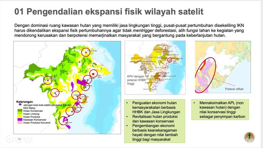
Copyright ©Pusat Transformasi Kebijakan Publik, 2020

Pusat Transformasi Kebijakan Publik
Kompleks Liga Mas Indah. Jl. Duren Tiga Indah I Blok E2 Nomor 11, RT 13 RW 7, Duren Tiga, Pancoran, Jakarta
Selatan – 12760. INDONESIA
www.transformasi.org, info@transformasi.org, 021-2702401

Author: Lucas Romero
Reviewers: Ethika Fitriani, Bambang Wicaksono, Buyung Yuliandri Setiawan, R.A. Nidha Nadia, Aizah Fajriana Dewi
Handini
Design: Aizah Fajriana D.H
Production: Pusat Transformasi Kebijakan Publik, 2020
CONTENTS

1        Policy Issues

     3        Research Question

     3        Purpose (Objectives)

     3        Output

     3        Results (Outcome)

     4        Methodology

5        Findings and Analysis

24       Conclusion

25       Recommendations

26       Bibliography

Appendix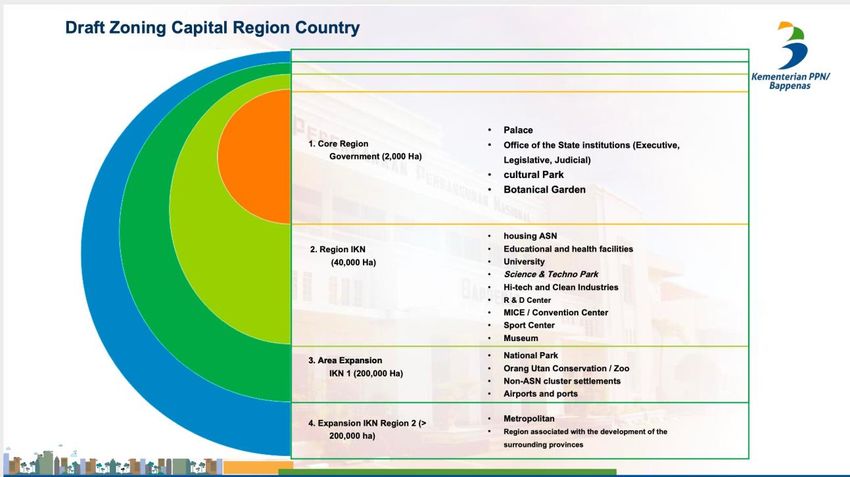
Policy Issues
Indonesia Capital City Relocation
Analyzing the Relocation Process of the Indonesian
Capital City
Lucas Romero

Policy Issues
On 26 August 2019, President Joko Widodo (Jokowi) publicly officialized the relocation project of the
Indonesian capital to East Kalimantan, to the regency of North Penajam Paser, and partly to Kutai
Kartanegara1, after discussions about the choice with the Central Kalimantan region. The current national
capital, Jakarta, will then be relocated at a distance of about 1200 km, on another island of the
archipelago, from Java to Kalimantan.

This relocation of the capital will give rise to a so-called "planned" city, built from scratch. This type of
project has already been observed in some countries, with varying degrees of success. One of the main
challenges facing this type of process are the urban issues that can arise from it, whether at local, regional
or national level.

According to the government's public communications, the master plan and regional technical planning
will be developed in the year 2020, with land acquisition and construction beginning in 2021. In
accordance with the government plan, the central area that will house government offices will be
developed between 2022 and 2024, and by 2024 the relocation process is expected to begin.2

In terms of demography, the first to be affected by this relocation are civil servants, who could "all move
to East Kalimantan in 2024", as President Joko Widodo (Jokowi) publicly assured on 17 January 2020.3
Despite this, legally, there is still no precise law governing the conditions of selection for civil servants and
the exact number of individuals who will be affected and/or exempted.

From an urban planning point of view, the government has frequently, as in the data provided by
Bappenas/Ministry of Development, referred to the objective of building a green and smart city, with
mass transport systems and autonomous and electric private vehicles, as well as pedestrian and bicycle
paths4. This new city model is presented as an answer to Jakarta's urban problems, as a better city without
the main inconveniences and risks of the current capital, such as flooding or traffic jams. In spite of this
observation on the part of public policy, the relocation process does not explain the mechanisms that
could be beneficial to Jakarta's current situation.

From a legal perspective, the relocation of the capital is a unique and unprecedented case and
therefore requires some adaptation of the current planning legislation.

At present, the Deputy for Regional Development of the Ministry of PPN/Bappenas, Rudy Suprihadi,
indicated on 22 January 2020 that a draft law, "RUU Ibu Kota Baru", was due to be released in mid-20205,
after having been submitted and examined by President Joko Widodo (Jokowi). This new law will regulate
territorial planning in the East Kalimantan region, where the new capital will be located. Indeed, this draft
law currently being prepared envisages that the regional government will not oversee the development
and legal management of the city. The new national capital will be managed by the national central
government, as Suharso Monoarfa, Head of Bappenas/Minister of National Development Planning, said
on 4 February 20206. The DPR (People's Representative Council) will oversee the project and
management, with no provincial or regency authority. This represents a legal dilemma.

Considering the short period of time between President Jokowi's official announcement of his intention to
relocate the capital and the rapid deadlines, the project does not yet have an established legal basis.
The legal basis is still being developed and the official documents are still incomplete.

                                                                                                             1
Finally, for the time being, two ministries are assigned to carry out and direct this project, the Minister of
National Development Planning (Bappenas) and the Minister of Public Works. The first of them reported
having examined the elements that justify or not a transfer, based on a few criteria such as economic,
social, political, cultural and environmental 7. It was on the basis of these elements studied that the
decision to relocate the capital was taken. While a few studies by Bappenas on these aspects of urban
policies have been presented, public communication and transparency of the results of these studies
remains limited to this day.

In addition to the departments planned to lead this process of relocating the new capital, an authority
agency will lead the project. « For the State Capital Authority Agency, we will indeed immediately sign a
presidential regulation where there will be a CEO. » Jokowi said at the Presidential Palace, Jakarta,
Monday (2/3/2020)8. This authority agency will be responsible for leading the process of moving and
building the new capital city.

Despite the timeliness of the studies and the limited reporting of their results, the ministries indicate that
examples of capital relocations have been examined to understand which aspects could or could not
be replicated. However, on the basis of the Bappenas data, the examples studied and presented, it
seems that only the positive aspects have been retained, omitting certain aspects of public policy to be
taken into consideration, from an economic, social or governance point of view.

The ministries also expressed the need to mobilize public opinion, as mentioned by the Minister of Public
Works and Housing (PUPR), Basuki Hadimuljono, on Friday, October 4, 2019. To date, apart from the
national dialogues, where experts, officials and academics have exchanged, no public consultations
have been carried out.

A capital relocation as mentioned here raises many questions, in several fields. Urban planning issues, the
effects on the former capital and the maintenance of an elective governance despite the distance are
major factors to be considered.

This paper aims to analyze the various urban issues surrounding the relocation project, based on the
official planning documents as well as on academic studies that raise question on the subject. The main
aspects of urban planning will be studied, namely economic, social, financial, judicial and spatial
aspects. The existing cases of relocation of several capital cities allow us to wonder about the risks and
challenges involved. The choice of Brasilia will be discussed, for the similarities it has with this project. Then,
the effects on the Jakarta situation will be questioned, and finally, the governance challenges presented
by this transfer of governmental functions will be studied.

                                                                                                                 2
Research Question

1) Which comparable examples of capital relocations could be taken as a reference? Is the case of
   Brasilia a model to follow? In which aspects can it serve as an example?
2) To what extent can the new capital benefit to Jakarta and improve its urban issues?
3) How this transfer of capital can lead to better governance on the part of the government for the
   Indonesian people?

Purpose (Objectives)

1) Conducting policy analysis about the challenges in terms of urban planning around the relocation
   project of the Indonesian capital.
2) Identify the key points and the issues of public policy around this project, in order to formulate
   recommendations for decision-makers to improve the effectiveness of the process.
3) The aim is also to raise public awareness of the urban and governance challenges surrounding this
   process, for the sake of transparency.

Output

1) A policy paper and a policy brief on the urban issues and limits to be taken into account in
   the elaboration of the capital project, by providing information and recommendations on
   aspects of urban planning.
2) Attached articles on specific topics mentioned in the policy paper, in the form of
   vulgarization and illustration for public information.

Results (Outcome)

1) Promote evidence-based policy-making (evidence based policy) to the Ministry of National
   Development Planning of the Republic of Indonesia / Bappenas, in order to create better public
   policy (better policy making) in the field of urban and spatial planning.

                                                                                                   3
Methodology

This policy research will use qualitative approach.

Methods of data collection will be done qualitatively. Data collection techniques include: (A) Desk
Study;
(B) Interview with key informants and (C) Secondary data.

Data collection instruments include:

- Analysis of official Bappenas/Ministry of Development documents, as well as on the events
  "Dialog Nasional »
- Analysis of official government press releases concerning the transfer of the capital, to analyze
  information and transparency towards the public.
- Academic research and interaction with Brasilia case researchers, who can provide a relevant
  and useful point of view, on the various urban aspects.

                                                                                                      4
Findings and
    Analysis
Findings and Analysis
A. The example of Brasilia
In the context of this relocation of the Capital, several examples of countries that have already carried
out this type of project were mentioned. One of the most significant is the case of Brazil, whose capital
moved from Rio de Janeiro to Brasilia on 21 April 1960.
This example was cited several times in official government communications. First by the Ministry of
National Development Planning of the Republic of Indonesia "Bappenas" in the documents presented
during the "Dialog Nasional VI" event, on the 11th February 2020 9, but also during an intervention of
the Brazilian ambassador in Jakarta, Ruben Barbosa during the "West Merdeka" event. In fact, he had
then expressed the "many tangible benefits" observed following the relocation of Brasilia.10 Among
the main arguments put forward to promote the success of the Brasilia project, R. Barbosa first of all
highlighted economic success, with, for example, the highest income per capita in the country. He
connects the cases of Jakarta and Rio de Janeiro, citing them as two cities "that were growing so fast
that they could no longer accommodate the government". Indeed, certain points of convergence
can be observed in the reasons for relocating these capitals (national, demographic and economic
equilibrium).The relocation of the former Brazilian capital corresponded to a desire to decentralize
the development monopoly of coastal cities. This aim to decentralize also corresponds to one of the
reasons driving the Indonesian project.
The analogy between these two cases is therefore made here, with the case of Brasilia, which is cited
as an example to be followed and presented as a successful model. It is indeed an interesting
comparison in several aspects, as there are various relevant points of comparison with the Indonesian
case. Firstly, the geographical aspect, with the distance between the former capitals (Rio de Janeiro
and Jakarta) and new locations. There are other interesting aspects to be observed in the case of
Brasilia, which 60 years after its construction presents certain urban issues that could be repeated in
the case of the new Indonesian capital. They concern in particular the socio-economic aspect, with
the inequalities that Brasilia concentrates despite its highest per capita income in the country, the
urbanistic aspect with a particular city model, as well as the environmental aspect with the risk of
exploiting local resources and the challenge of protecting green areas and protected species.
These different aspects will be explored in this part on Brasilia, based on evidence data on the current
urban situation of this new capital, to illustrate the challenges that can be observed in an example
comparable to the Indonesian case, in order to understand the urban issues that may arise in this
relocation project, in order to propose recommendations or "best practices" and for informative
purposes. It does indeed seem relevant to compare these two cases in terms of common aspects and
issues, as well as to inform public opinion on the aspects omitted in the official communications.
1. Geographical presentation of Brasilia
The new Brazilian capital represents an example of a "planned-city", built within a specific policy
of decentralization and territorial occupation as well as a socio-functional utopia11. This project
for a new government capital had clear objectives of social integration and a democratic
national symbol, with a modernist architectural city model 12. The urban planning project is based
on a low- density city with large distances, with a total area of 581,400HA based on road transport.
The initial project called "plan piloto" strictly concerns the urban development of the core area,
with a governmental town planning aim only, to accommodate civil servants and regroup
administrative functions, as Catherine Aubertin, research director at the Institute of Research for
Development IRD, an expert on the case of Brasilia, explained when we were able to interview
her.
5BRASILIA SPACE ORGANIZATION
Map from; "Brasília, ville fermée, environnement ouvert, IRD Éditions, 2006"
https://books.openedition.org/irdeditions/361? lang=fr#authors (Source: Seduh-Situr-Sicad,Seplan-SIEG-GO)
Socio-spatial organization:
Regarding the socio-spatial organization of the city of Brasilia, it is divided into 4 zones, a central
core, a close periphery, then, a first and second ring, in circular distribution (D. Couret, 2006). Being
built as a government centre, the inner city environment is reserved for the upper classes, who
benefit from the best access to the services. The "plan piloto" remains respected until today in the
central area, in the limits that were initially planned, but many peripheries have since developed,
where the socio-economic difficulties are concentrated, far from the central power. (D. Couret,
2006)
As mentioned, the original urban project represented a symbol of a socialist utopia. It was
materialized by a strict urban plan with a set of highly constraining urban planning rules to maintain
a "positive" urban environment. However, recent urban studies on the case of Brasilia
demonstrate a strong socio-spatial heterogeneity, with a « social fracture »13 between the
populations of the center and the peripheries which concentrate poverty. This therefore illustrates
a geographical rupture associated with a social rupture. Indeed, the city of Brasilia today has an
average monthly income 2 to 3 times higher than the rest of the country 14, but this covers the
strong internal inequalities of the city, regardless of the high precarity of the populations located
in the periphery, which often have the least well paid jobs in the service sector, with daily trips of
3-4 hours15 to go and return to the downtown area.
The argument frequently used to promote the success of the new Brazilian capital is the economic
argument of the highest income per capita in the country, as mentioned by the Brazilian
ambassador16. Nevertheless, it seems important to point out that this value hides extreme values
with strong internal inequalities, with the highest income gap and ignoring the situation of the
peripheries and the new emerging favelas17. These elements therefore should not be ignored
when the example of Brasilia is taken as a symbol of political and economic success.
62. Distance to the initial project and extension risks
As seen above, the points of comparison between Brasilia and the relocation project of the
Indonesian capital make it an interesting example in the elaboration of this transfer, which
represents a large urban project. The other advantage of taking this example as a reference is
the date on which the project was built (1960), which allows sufficient hindsight on the situation,
with a study of the successes or failures that can be observed. This makes it a valuable model,
not to be used and copied, but to learn from the potential mistakes that should not be repeated.
In this section, the differences that may exist between the original project and the current situation
will be discussed. This may allow an interesting observation, as it demonstrates the necessity of a
strong legal basis to ensure continuity in the project, from its birth to its long-term operation, to
ensure its durability.
The pilot plan for the Brazilian capital, led by J. Kubitschek, planned a clear urban model : that of
a governmental tertiary pole (M.R De Andrade, I.C Barbosa Ferreira, 2006). Despite this precise
and clear model, which was fixed at the origin of the project, and a strict pilot plan, over the last
few decades and since its creation, Brasilia has experienced an "evolution comparable to many
Brazilian cities" (M.R De Andrade, I.C Barbosa Ferreira, 2006).
Built to accommodate decision-making units and civil servants, within a specific framework,
without any economic or demographic development objective, the city now finds itself in a classic
urban development scheme, with a model that tends towards a value-producing city18 . This loss
of coherence of the initial project illustrates a "dilemma" that the city has faced from its creation
to the present day. In fact, the initial project of an affirmed socialist utopia has given way to the
development of liberalism (A.M Nogales Vasconcelos, 2006).
In fact, the lack of coherent long-term management has not made it possible to contain the
development of the city, which was made to accommodate 500 000 people, and which
accommodates some today almost 3 million (M.Haberard, N. Ransom, T.Prado,
2016)19. The consequences of this development are the same dysfunctions and urban fractures
observed in other cities of the country and capitals of the South (socio-economic inequalities,
urban precariousness, informal housing, etc.). Sixty years later, urban studies report urban
dysfunctions common to the rest of the country, (Marília Steinberger, 2006) which is a sign of failure
considering the national hopes for a renewal that this project symbolized.
Extension risks:
The pilot plan of the Brazilian capital has so far been respected, within the limits of the central
area. But uncontrolled development concerns the peripheral areas, which concentrate the socio-
economic stakes and problems. These territories are represented by the "satellite" cities, urban
poles formed around the pilot plan of Brasilia. It is in these territories that the most intense
development is concentrated, and which supports the economic and demographic growth of
Brasilia (C. Aubertin, A. Morel, 1989)20. These cities were not included in the original project, so
their rapid development was unplanned and unframed. Historically, the origin of these satellite
cities has been the installation of national migrants, especially the workers employed to build the
city, who claimed their right to live in the city they had built, before its inauguration.(M.
Steinberger, 2006)21. The government therefore agreed to house them in these outlying areas (M.
Steinberger, 2006). This constituted the first "exception" to the original plan, which subsequently
continued to evolve. Indeed, until 1987, the city experienced what have been called "invasions",
of these modest populations in search of economic opportunities, who resided in the peripheral
7areas of the pilot plan, in informal settlements (M.S Da Silva, N.A De Melo, 2006). It was therefore
after 1987 that several satellite cities were formally built to house these people. (C. Aubertin, A.
Morel, 1989).
"This solution found to the housing problem of the disadvantaged population therefore signified
the exclusion of workers from the Plano Piloto perimeter. That was the origin of the socio-spatial
segregation that characterizes the city today. »(I.C Barbosa Ferreria, 2006). The risk of extension
also corresponds to the issue of population distribution as well as housing issues. For example, in
the case of Brasilia, the base city was built to house civil servants, but the plan did not include
housing for the popular classes (C. Aubertin), which are always necessary for urban development,
especially for the service-sector jobs generated by the presence of the state functions.
This case study highlights key factors to be taken into account in the development of the
Indonesian capital, which have sometimes not been cited in the studies published to date in order
to carry out the project. It is therefore important to specify from the outset the objective of the city
model envisaged, to inform the population and prevent possible "invasions" unplanned
demographic displacements. Also, to establish a strong legal basis for planning and monitoring
developments, to limit the emergence of urban issues already present in other metropolitan areas,
which might not be reproduced in such a project.
The case of Brasilia illustrates a major challenge, in today's urban systems (based on the
concentration of economic production and poles of wealth) : it seems impossible to contain
expansion in a contemporary city (C.Aubertin). This therefore represents a major challenge in the
formulation of the IKN project, in its legal framework but also in the urban planning models and
plans that will be produced. Indeed, a strong legal basis is recommended, with urban planning
rules that aim to regulate spatial development, but also an integration of the risk factor of this
extension, which could be managed proactively if this risk is taken into consideration from the
very beginning of the project.
The question of demographic flows and migrant workers are also major issues and challenges
that must be integrated into a solid and transparent framework. The spatial extension is a
particularly crucial challenge in the case of the future Indonesian capital, in view of its
geographical location. Indeed, this concern is major in a territory such as East Kalimantan, with
the environmental issues that it concentrates.
3. Environmental aspect
The study of the case of Brasilia and the evidence that can be observed since the construction of
the capital highlight one of the major issues to be taken into consideration in the relocation of the
Indonesian capital: the environmental issue. The location of Brasilia is indeed a place rich and
unique in biodiversity, located on the central Brazilian plateau, with a savannah climate, with the
«cerrado» ecosystem (M.R.De Andrade Mathieu, 2006). Despite the different climate, this
concentrates common issues at the location of the future Indonesian capital. The case of Brasilia
therefore also represents a convincing example to be taken into consideration in the management
of the risk of environmental degradation, with lessons to be learned from the results now visible from
the baseline plan.
From a planning and design point of view, the studies that preceded the construction of the
Brazilian capital show the awareness of the importance of the environmental factor. In fact, the
pilot plan included a strong notion of natural preservation. The design of the city included a
"sanitary cordon" that separated the central and peripheral areas, like a green lung (N.Penna,
2006)22. These rural green spaces had to respect a low density, including natural preservation
areas. This aim of environmental preservation was a strong aspect of the planning of the new
8capital, since about 50% of the total area of the "Distrito Federal" was destined for nature reserves
(APAs: « Areas de Proteção Ambiental »). (N.A Penna, 2006) These were intended to protect the
peripheral areas from uncontrolled urban sprawl, which would deteriorate the rich surrounding
environment.
This concern for environmental protection had to be supported by planning regulations, such as
two main laws:
- The health code of the Distrito Federal (Law No. 5027, of 14-06-1966), limits the establishment of
housing in the areas of basins and watercourses, to avoid the risks of pollution and
contamination of the water tables.
- The Water, Sewerage and Pollution Control Master Plan - Planidro (CAESB, 1970), created to
protect the areas surrounding Lake "Paranoa", preventing urban expansion and growth.
These areas protected by the original plan quickly became vulnerable territories as the new
capital's urban development progressed. The main threat to the preservation of these rural
protected areas is the expansion of the real estate market (Penna, 2003). Over the years, these
areas have been occupied by numerous private properties, with alternatives and bypasses to
planning and implantation laws23 . Urban areas have expanded illegally, despite government
efforts, with the development of numerous housing developments in the heart of these natural
areas. This symbolizes the failure of the public authorities to limit urban spatial expansion and
especially the protection of vulnerable natural areas (Penna, 2003).
Finally, this is another consequence of the difficulty in controlling spatial extension, which directly
results in a degradation of the surrounding environment, despite the initial awareness and
regulations put in place.
EVOLUTION OF THE URBAN SPRAWL OF THE AGGLOMERATION OF BRASILIA BETWEEN 1964 AND 2000
Map from ; "Brasília, ville fermée, environnement ouvert, IRD Éditions, 2006" https://books.openedition.org/irdeditions/361?
lang=fr#authors (Source: Projet géographique-cartographique de Rafael Sanzio Araujo dos Anjos, 2002
9This map illustrates the failure to "control" urban sprawl, which directly led to environmental
degradation of the entire area.
As it has been observed, the case of Brasilia represents the difficulty of containing urban sprawl in
a territory rich in environmental resources, and therefore at risk. This can be put into perspective
with the case of IKN. The case of Brasilia provides many lessons to be learned, in the difficult
management of expansion and the high environmental risk. These issues are reflected in the case
of IKN, with its territory in East Kalimantan, known for its rich biodiversity and environmental issues.
It is important to see what the environmental issues are in the area planned for the capital, and
then try to examine the mechanisms that the government plans to try to limit a destructive
expansion. The contributions of Walhi, Forest Watch Indonesia, Jatam, Pokja and Trend Asia24
already provide a comprehensive explanation of the environmental issues and related risks to local
biodiversity. Their research will therefore be used to put the point made here into perspective.
Ecological risks:
The Ministry of National Development Planning of the Republic of Indonesia/Bappenas, partly in
charge of the development of the future capital, has already conducted several studies and
presentations on the territorial context of the area concerned.25 In these presentations, the area
is presented as having the advantage of being a "disaster free" zone.
Moreover, the will to develop a "green" and "sustainable" city is a factor regularly repeated in
the different communications.26 Taking these arguments into consideration, it is interesting
to put them into perspective with the environmental studies carried out on this territory, as well as
with the example of Brasilia, which demonstrates the difficulty of planning and building a city that
does not threaten the local environment. Several elements are in fact put forward by the report. It
mainly refers to the strong presence of energy extraction industries in the region, forest fires, as well
as the danger to animal protection and biodiversity. These elements will be taken up to evaluate
how these factors could make the development of a major urban pole threatening the local
environment.
First of all, the project promoted by the government and the ministries dedicated to its elaboration
have often promoted a sustainable project, with the name "forest-city" often mentioned27 . Yet,
as the NGOs report28 points out, no group of environmental experts or activities have been
consulted, from the choice of the location to the development until now. The Bappenas
documents as well as the presentations made at the Dialog Nasional events often mention a
territory rich in natural resources, which would be sufficient to support the development of a
city, including strong clean and available water resources29 . However, some experts, as Bagas
Pulijaksono (Uni Gadjah Mada, Yogyakarta) informed about the risk of water supply crisis in the
region30. In fact, water supply crises have already been occurring in the Balikpapan region
in recent years.31 Also with regard to the water resources present in the subsoil, some experts
expressed some concerns. For example, Professor Bagas Pulijaksono (Uni Gadjah Mada,
Yogyakarta) informed about the lack of available resources, with a lack of deep-water tables and
water resources only available on the surface. This evidence obviously raises the question of the
region's capacity in terms of resources to host such a project, with all the needs it implies.
Concerning the environmental risks related to water, the government also communicated on the
advantage of the area which would not present a risk of natural disasters of flooding. This is
therefore presented as an advantage that supports the need for relocation against the known risk
of flooding in Jakarta. The vulnerability to flooding in the Balikpapan area and the coastal zone of
10the region has however been demonstrated by studies on the subject « Meanwhile, Flood
Vulnerability Index values are in the range of 0,25 to 0,75 which are spread along the Balikpapan
Bay’s coastal area, which are located on the location that planned for plantation area, fishery
area, limited production forest, conversion production forest, and industrial area. Which means that
the Balikpapan Bay’s coastal area has become prone to flood ».32
As in the case of Jakarta, hydrological studies33 show that the main factor causing floods
is massive urbanization and concreting which disrupts the natural water-absorbing function of the
soil and does not allow the process of infiltration, which leads directly to water accumulation and
flooding. Vulnerability to flooding is therefore mainly due to mass urbanization, which is important
to control and regulate. In this case, it would seem advisable not to present the area as free and
protected from natural disasters, especially floods, but rather to assess the risk based on the studies
carried out and to use the case of Jakarta as an example that should not be reproduced in order
to achieve more responsible and sustainable urban management.
The coastal territory also has an area of mangrove swamps. This type of natural space makes it
possible to protect and prevent the risk of flooding through its strong natural infiltration
functions34. It would therefore be important to preserve these spaces through strong legislation
and not to urbanize these areas. This space is located in zone 1 of the development plans of the
capital, according to the presentations of Bappenas35. As mentioned above, projects and official
presentations often referred to the promotion of the area on the basis of the argument that there
is no risk of natural disasters. However, it seems important to nuance this statement and to inform
about the risks present. Indeed, the environnemental NGOs36 report informs that the main risks are
"forests and land fires", as well as the risk of tsunami, according to several experts. This risk related
to forest and land fires is also supported by Professor Bambang Hero S (Bogor Agricultural Institute),
during the National Dialogue VI, with the increasing recurrence of this kind of event on Kalimantan,
until recently in 2019, with many "hotspots", a total of 18 in the region. These events are directly
linked to industrial activities and deforestation, which has a strong impact on the environment.
Then, one of the major environmental risks linked to the development of the capital in the area
concerns the vulnerability of biodiversity. In fact, the area chosen for this project is an area rich in
fauna and flora, with many endemic species as Orang-outa or Bekantan (Paulus Matius, Uni
Mulawarman, Dialog Nasional VI), already endangered by the industries present in the region.
These areas and protected species could suffer from the relocation project if uncontrolled urban
expansion is allowed to take place. Moreover, the biodiversity of the region also concerns the
coastal area, with the Bay of Balikpapan, which has marine species such as dolphins, which are
already impacted by port activities with oil spills37.
Finally, the Ministry of Planifications Bappenas has often referred to the ecological crisis of the
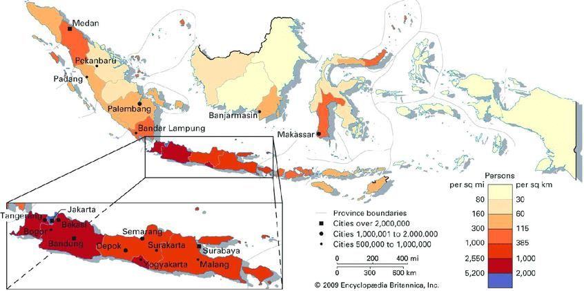
densely populated island of Java 38, which suffers from the intensive exploitation of natural
resources. This "eco-crisis" comes directly from the high concentration of populations and urban
centres. These natural risks are therefore directly caused by urban human activities. A simple
geographical relocation may appear as a solution but could also be a vector of new risks, such as
the deterioration of a new natural environment, in the new location, as well as an "abandonment"
of the ecological problems of the island of Java, which will not simply be solved by a relocation of
the capital, but which require regular and coherent attention, with planning of environmental
protection strategies.
It would be advisable to conduct a formal and public study, mobilizing experts from the area,
allowing transparency on the risks of the territory and the methods put in place to limit these risks.
The case of Brasilia shows that despite risk awareness and some planning laws, urban development
11that is difficult to control ends up threatening the local environment. It therefore seems important
to carry out precise and evidence-based studies, as well as strong control and protection measures
included in the legal basis of the draft planning law.
In response to these concerns, the government has formulated, through the presentations of the
National Dialogue, some responses, by the Member of Parliament for Bappenas, Slides "Smart,
Green, Beautiful and Sustainable". They mainly refer to a "one river, one management" river
management system. They also communicated on the aspect of the "forest-city", with 75% of urban
green spaces, by converting palm oil and mining industry areas into forest areas. These projects
are obviously encouraging, and the Ministry of Planning's awareness of the environmental aspect
is essential. However, it is important to remember that these ambitions must be transcribed into a
strong legal planning basis for urban construction and long-term management and control.
CONTROLLING PHYSICAL EXPANSION OF THE SATELLITE AREA
Source : Executive summary of recommendations for strategic environmental study (KLHS) for the relocation of the
capital state city (IKN). Ministry of Environment and Forestry, 11 February 2020
In addition, the Ministry of Environment and forestry's presentation (Slides "KLHK" Ministry of
Environment and forestry, "Executive summary strategic recommendations for Environmental
assessment, transfer of capital state: Prevents on the ecological risks and constraints of the territory)
seems to include the issue of urban sprawl and satellite city planning, as we see above.
This type of planning is reminiscent of the case of Brasilia and its satellite cities studied earlier. Unlike
Brasilia, where these satellite cities were not planned and included in the original project, it seems
essential here not to repeat the same mistakes. It would be judicious to include this strategy clearly
in the basic legal plan of the capital, with a clear urban policy, which would anticipate the
location, size and organization of these satellite cities. Specifying a clear and strong legal urban
planning plan would make it possible to limit urban expansion and limit environmental problems,
by focusing attention on the risk and difficulty of containing the development and extension of an
urban area (recalling the example of Brasilia).
The case of Brasilia is still very relevant and interesting. On the spatial and environmental issue, the
main lesson to be learned is that despite planning regulations, an extension is extremely difficult, if
not impossible to contain, to limit the environmental risk. In view of the natural richness of the East
Kalimantan area, the government has taken into consideration the major issue at stake here. It is
important to point out, based on the case of Brasilia, that plans and regulations are sometimes not
12sufficient to contain long-term spatial growth and environmental protection. A strengthened legal
basis will therefore have to be formulated, but also associated with strong, regular and coherent
long-term monitoring tools.
To specify that, in comparison, the case of IKN seems to concentrate even more sensitive
environmental issues than the case of Brasilia (which itself has difficulties in maintaining the
protection of natural areas). This therefore requires a special focus on this issue. With strong tools,
and not just a "green city" model. A city, by its very nature, concentrates human activity and
therefore endangers natural and animal activity.39
4. Regional integration
Based on the study of the urban problems of the planned capital of Brasilia, another development
challenge seems to be regional integration (M.R De Andrade Mathieu, 2006). Indeed, a new
capital planned and centrally managed by the national government may question the role of this
city in the regional context, as well as the levels of political management.
In the case of Brasilia, in spite of the strong economic and urban development of the city, which
was initially planned to accommodate the 3 state powers40, but which today has become an
economic and demographic centre, the city seems to be taking the role of a centre of national
influence, but not a regional one (M.R De Andrade Mathieu, 2006). In fact, since its construction,
the city has not generated any regional growth impulse.
This territorial and decision-making issue presents an important example to be taken into account
in the development of the IKN. Indeed, the project is also led by national level authorities. « The
new national capital will be managed by the national central government », as Suharso
Monoarfa, Head of Bappenas/Minister of National Development Planning, said on 4 February
202041. « The DPR (People's Representative Council) will oversee the project and management,
with no provincial or regency authority. » as said in the introduction. However, in consideration of
the location of the project, in the East Kalimantan region, it might be judicious to include local
decision-makers in the development of the project, who could defend the interests of the area,
as well as provide a positive impulse for growth and integration at the economic, ecological and
demographic level.
In the case of the relocation of the Indonesian capital, regional integration also involves taking
into account local socio-cultural issues. The planning of a new capital on this territory raises the
question of the integration of the local populations, at the economic, spatial and cultural level.
Successful integration will help to avoid local conflicts.
To address this issue, a document prepared by the "Expert Staff of the Minister of PPN for Social
Affairs and Poverty Reduction" asking for the exact translation (Staf Ahli Meter PPN Bidang Sosial
dan Penanggulangan Kemiskinan) was presented at the last National Dialogue organized on
February 25, 2020, in Depok. This document discusses the socio-cultural issues surrounding the
relocation project of the capital city and gives some recommendations to the government.
This preliminary study presents the 3 major issues to be taken into account, such as cultural identity,
land ownership issues, and employment and business opportunities, while recalling the objective
of national unity that accompanies this project, and which therefore justifies the integration of all
citizens. According to them, based on BPS 2010 figures, the East Kalimantan region is populated
by 17% indigenous people (Dayar, Paser, Kutai) and 83% migrant communities (Javanese,
Buginese, Banjar and others). This demographic and cultural structure should therefore be taken
into account in this project, with the aim of integrating everyone, in order to avoid social conflicts
with the new arrivals.
13This document specifies the need to take into consideration this cultural diversity, preserving the
identity of each one, in order to link the communities and avoid the risks of conflicts. By presenting
the local social context, they specify the social challenges that exist in this territory, such as health
concerns and access to health care, or transportation infrastructure issues that do not allow equal
access to education. With regard to the three main themes presented by the Ministry of the PPN
for Social Affairs and Poverty Reduction, the issue of cultural identity mainly concerns the
indigenous populations, and in particular the Dayak tribes, with the issues of transmigrations and
resettlement. These population displacements provide better access to public services,
particularly health care, but have the disadvantage of cultural assimilation and loss of identity,
with a weakening of local culture.
SOCIO-CULTURAL RECOMMENDATIONS FOR THE DEVELOPMENT OF THE IKN, FROM THE MINISTRY OF PPN ON SOCIAL
AFFAIRS AND POVERTY REDUCTION
Source: « Kajian Awal Aspek Sosial Pemindahan IKN » Staf Ahli Meter PPN Bidang Sosial dan Penanggulangan
Kemiskinan » Depok, 25 February 2020, during Dialog National VII
To respond to this challenge, the staff specifies that the relocation of the capital represents a
"momentum" to improve the quality of human capital, as well as to strengthen local identity
through the integration of culture in the development of the IKN, with a view to promoting plurality
and harmony. Regarding land ownership issues, they advise using this transfer of capital as an
opportunity to resolve territorial conflicts and the local environmental vision for nature
conservation.
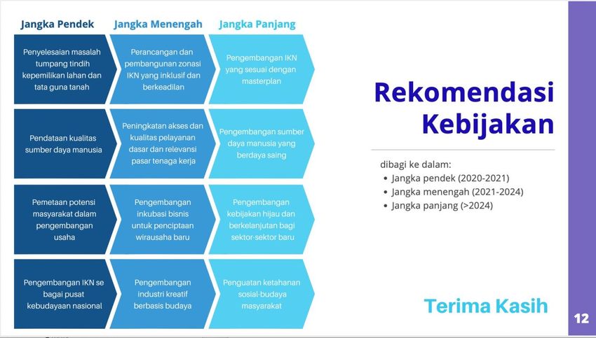
Finally, they formulate short, medium and long-term recommendations for social and cultural
integration in the IKN project. For the short-term vision (2020-2021), they advise to solve land
ownership and land use concerns, as well as data collections on the quality of human resources,
and a mapping of the potential of the local community in business development.
Then, for the medium term (2021-2024), they recommend inclusive and fair urban design and
zoning, improved access to quality basic public services, as well as business incubation for the
creation of new entrepreneurs and the development of a creative industry based on local culture.
14Finally, for the long term (>2024) they advise the development of the IKN in accordance with an
established master plan, developing competitive human resources, as well as green and sustainable
policies for new sectors and a social strengthening of the cultural resilience of the community.
These recommendations therefore include the different aspects of socio-cultural integration, through
socio-economic, human, spatial and environmental aspects. In addition, they recommend the
integration of local communities in urban planning and zoning, with the objective of an integrated
and inclusive capital city. This preliminary study on the comprehensive socio-cultural aspect presents
a broad spectrum of socio-cultural issues and possibilities for action.
The socio-cultural issue seems to be at the heart of the local, regional and national integration issue,
representing all the communities present and avoiding local conflicts that may have already existed
during transmigration policies.
These issues indeed appear to be a major challenge in this process of transfer of national capital.
These studies that have been carried out must now be clearly included in the relocation bill. Only a
clear formulation in a solid legal basis would make it possible to set up the tools for socio- cultural
integration, both at the level of public services, cultural representation and socio-spatial integration
with an urban zoning that includes all local populations.
In sum, the study of the development of Brasilia provides important lessons to be taken into
consideration in the elaboration of the project for the new Indonesian capital. The evolution of the
situation in the former capital, Rio de Janeiro, also raises questions about the effects that this project
could have on the current capital, Jakarta.
B. The effects on Jakarta
In order to answer to the second question « To what extent can the new capital benefit to Jakarta and
improve its urban challenges? » it is needed to observe the communication made by the government
about the mechanisms and scenarios that could operate between the new capital and Jakarta.
The relationship between the ex-capital and the future capital raises a few major aspects, such as the
role of the new capital, the city model of the project and the connections between the two cities.
In the public communications, the government often used the urban issues in Jakarta as an argument
to raise the need of a new capital city. As communicated during « Dialog Kajian Pemindahan Ibu Kota
» Dialogue about the transfer of the Capital City, by Bappenas and Kementarian PPN (ministry of
National Development Planning), the two major spatial and urban arguments for relocating the capital
city are : the need of decentralization, due to the eco-crisis we referred to before, and the «
increasing burden of Jakarta, the decline in support of the environment and economic losses ».
Indeed, the urban issues such as the high congestion and bad transportation management systems,
and environmental risks such as flooding and sea rise level are big and urgent concerns that are
already well known and studied. Those issues are elements that needs strong supports from public
policies and long-term treatments, in order to resolve them. Indeed, as explained before, most of the
environmental risks known today in Jakarta originate from human activities and urbanization. It is
indeed important to treat them effectively, and try to examine how this project could help in this
direction.
151. Which city-model for the new capital?
First of all, it seems important to specify that in geography, the term "capital" means "a city
characterized by the presence of the headquarters of the administration and government of a
state. "(Antoine Laporte, "Capitale", Hypergéo, 2014). This characteristic alone can be sufficient to
define a capital city. However, in the collective imagination, a capital often refers to
representation of a major city (economically, culturally, demographically) on a national or even
international scale.
In the project to relocate the Indonesian capital IKN, it is important to determine the objective and
the city model targeted, as this will define urban policies, in terms of surface area, demographic
capacity, as well as in terms of the objective of economic attractiveness. A study of the official
documents makes it possible to question the model followed by the Ministry of Planning in the
project of the future capital.
This document by Kementarian PPN/Bappenas presents an idea of urban zoning for the planning
of the new capital and its region. The centre of the zone concentrates government activities, with
the 3 state roles present (executive, legislative, and judicial), as well as the presidential palace.
Then, the first peripheral zone would concentrate cultural and educational activities. Finally, 2
expansion zones are planned for protected areas and transport infrastructure. This plan informs us
on the primary governmental value that this capital would take, with the priority also being given
to relocating all civil servants by 202442.
DRAFT SPATIAL ZONING IN THE IKN PROJECT
Source : Minister of National Development Planning / Head of Bappenas, National Dialogue for the Transfer of the Capital City,
May 16, 2019
The project aims for a strong national symbol, with architectural monuments that represent the
Indonesian nation, as illustrated by the winning urban design project by Urban Plus. 43 The priority
relocation of government functions as well as the planned functional zoning seem to indicate the
project of a governmental city, as in the case of Brasilia, which could subsequently be expanded.
16Given the lack of formal communications or clear planning documents, it seems difficult to
estimate or predict which city model this new capital will follow. However, it seems important to
define the chosen urban model, in order to inform the citizens, but above all because the new
town planning and planning laws will have to follow a predefined city model. However,
informing
the public about the city model chosen for the new capital, between governmental pole or total
city, also means redefining the status of Jakarta. Indeed, if the IKN develops only as a
governmental pole, Jakarta would keep its economic and demographic monopoly, which would
not be a big change for the development of the current capital.
In sum, greater transparency is recommended here, in the communication of the IKN project, of
the city model targeted, and of the status Jakarta will adopt.
2. Urgent urban issues in Jakarta
Jakarta's urban issues have sometimes been used to explain the need to relocate the new capital.
Indeed, the current capital concentrates strong and urgent urban issues, which impact directly on
the daily lives of its inhabitants.
Among them, air pollution, mainly caused by vehicle emissions, which accounts for 71% of nitrogen
oxide and fine particle emissions in the capital (Hidayat, B., & Asri, D. U. 2005, « Current
Transportation Issues in Jakarta and its Impact on Environment ». Page: 1.792 - 1.798). These
degrade the atmosphere and endanger the health of the residents, with directly related diseases
such as infant mortality, asthma attacks, childhood respiratory problems, chronic bronchitis and
all symptoms of respiratory difficulties. (Source: Health and Economic Impact of Air Pollution in
Jakarta). These diseases as a whole have increased considerably, with infant mortality estimated
to rise from 3,305 to 7,893 deaths between 1998 and 2015 for the whole of Jakarta and asthma
attacks and chronic bronchitis doubling on average. Some parts of the capital stand out as being
even more severely affected, such as western Jakarta, where industrial activities are
concentrated. (Napitupulu, Resosudarmo, 2004). At the economic level, urban congestion and
traffic jams also cause negative externalities. Indeed, in 2002, an estimate of $300 million in
economic loss was calculated for vehicle losses and $250 million for time lost in transport (Sugiarto,
2015). Road traffic congestion has increased in recent years and the resulting economic loss is
estimated at $1.5 billion per year according to the Jakarta Transportation Office (lost time, health
costs and energy consumption) (Dewi, 2011). This pollution is directly related to human activities
and population concentration, but can also be addressed and solved by human solutions and
economic investments.
The other significant example of the burden of the capital on its current environment is the urban
problems of recurrent flooding. Indeed, Jakarta is known as one of the world’s fastest-sinking cities,
with rising sea-levels and extreme weather due to climate crisis. In the first days of January 2020,
the city experienced the worst inundations the capital has seen this century. Indonesia's
Meteorology, Climatology and Geophysical Agency measured 15 inches (38 centimeters) of rain
at an East Jakarta airport on January 1, the highest flood reading since 1996, Reuters reported.44
As mentioned earlier, these events are also due to human activities, due to the mass urbanization
and the size of the present capital. Again, it is not clear that relocation is more effective than
human- made solutions and eco-friendly urbanization strategies.
This idea of relocation to respond to the urban challenges of Jakarta raises the question of the most
vulnerable populations. As the new capital is primarily intended for civil servants and state
functions, it raises the question of how to manage the problems of the existing capital, when
attention and investment will be concentrated around the IKN.
17Finally, the example of Brasilia also informs about the management and development of the former
capital in the case of relocation. Indeed, during the "Dialog Kajian Pemindahan Ibu Kota" Dialogue
about the transfer of the Capital City, by Bappenas and Kementarian PPN (Ministry of National
Development Planning), the case of Brasilia was presented as a success story and an example
of territorial investment. However, one of the issues to be raised in this comparable case is the
benefit to the former capital, Rio de Janeiro. Indeed, this city today concentrates many urban,
social and economic issues. Indeed, it is internationally known for the strong presence of "favelas",
with a total population of 6.3 million inhabitants in the city of Rio de Janeiro in 2010, 20% of whom
are said to live in the city's 600 distinct favelas45. These are a source of social tension, as well as
significant drug trafficking, caused by high poverty46.
In this context, it appears difficult to affirm that, after 60 years of construction of the new capital
Brasilia, its development was beneficial for the ancient capital, Rio de Janeiro. Such a study could
once again serve as an example of lessons to be learned, with governance and urban
development mechanisms to be put in place, so as not to abandon the urgent issues of Jakarta's
vulnerable territories. Again, all these measures should be integrated into a strong legal basis, with
a global, long-term and holistic master plan.
3. Demographical impact on Jakarta
The supposed positive impact for Jakarta in this relocation process does not seem to be directly
evident, given the lack of directly exposed mechanisms. It is therefore necessary to question the
real effects that this change of capital could have on the city of Jakarta.
First of all, one of the mechanisms that could be used to consider decongesting Jakarta is the
demographic displacement. Indeed, it is possible to imagine that a significant population
movement would free the current capital from a certain demographic pressure, and thus allow for
assistance with regard to urban issues, particularly pollution and road congestion. Indeed, this is
the argument used by Anies Baswedan in April 2019, when he suggested that this project would,
with the estimated movement of 180,000 civil servants plus thousands of military and police
personnel, improve the condition of Jakarta, which is home to 10 million inhabitants 47 . As the
article points out, "There are 17 million registered private vehicles roaming Jakarta, only 141,000 of
which are government vehicles. "This gives an interesting idea of the proportion of movement and
the difficulty of improving the urban situation in this respect ».
The estimated figure of 800,000 citizens (civil servants, families and side workers) has often been put
forward48. Given the demographics of the extended capital of the Greater Jakarta with a
population of about 30 million 49, this proportion does not carry a significant weight in changing
the face of Jakarta and its environmental vulnerabilities.
Indeed, as noted previously, it seems clear, based on official communications, that the priority is
to move all public servants by 202450. No clear study shows a different objective, which would
allow a larger population to be moved. Moreover, as discussed in the previous sections, the
capacity of the new location must also be taken into account in the population mass to be able
to settle there.
Moreover, this project is not unanimously supported by the civil servants, with a survey conducted
by Indonesia Development Monitoring (IDM), from 7th to 20th August, 94.7% answered to not agree
to this relocation project mainly for financial, educational and health reasons, for fear of the lack
of infrastructure.51 The people exactly concerned are also not always clear according to the
government's public communications, for example with Tjahjo Kumolo, who had mentioned the
18You can also read