Appendix D.18. Grace Darling Park, Lancelin - Figure D 18: Grace Darling Park, Lancelin schematic
←
→
Page content transcription
If your browser does not render page correctly, please read the page content below

Appendix D.18.       Grace Darling Park, Lancelin

                      Figure D‐18: Grace Darling Park, Lancelin schematic

Assessment of Coastal Erosion Hotspots in WA 135                            Appendix D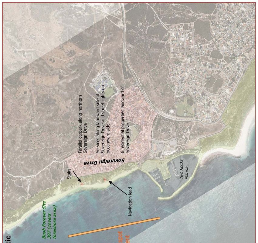
This hotspot profile must be read in conjunction with the Disclaimer on p.78 on the cover of Appendix D.
                     Table D‐18: Grace Darling Park, Lancelin summary information
 Hotspot No.              18
 Hotspot Name             Grace Darling Park, Lancelin
 Local Coastal Manager    Shire of Gingin
 Hotspot issue            Grace Darling Park is located on a sandy cuspate foreland in the lee of Edward Island and
                          reef systems with variability of the foreshore position of up to 75m in 70 years. The
                          variability in foreshore position is due to variation in weather and wave regimes and
                          sediment availability. Facilities were added to the park during a period of accretion, at a
                          maximum in 1994. The park has experienced rapid erosion from winter storms since 2012,
                          with
Management options        Avoid (N),
 for Imminent timeframe    Retreat (N),
 (0‒5 years)               Accommodate (N),
                           Protect (Y ‐ Increase sand renourishment volumes)
                           Preparation of planning frameworks for retreat in next level of management and identify
                           funding mechanisms.
 Approximation of cost     Protect ‐ L
 for Imminent timeframe    Prepare Plans ‐ 50k
 (0‒5 years) options
 (L/M/H)
 Trigger for next level    Trigger for next level management: Acute erosion hazard for existing facilities >2
 management,               months/year (i.e. ineffective nourishment)
 monitoring and            Monitoring: Photographic monitoring
 alternate management      Alternate option: N/A
 option (Imminent
 timeframe 0‒5 years)
 Management and            Avoid (N),
 adaptation options for    Retreat (Y ‐ Remove or relocate existing facilities),
 Expected timeframe (5‒    Accommodate (N),
 25 years)                 Protect (N)
                           Preparation of planning frameworks for retreat in next level of management and identify
                           funding mechanisms.
 Approximation of cost     Retreat ‐ M (cost may be higher dependent on land availability)
 for Expected timeframe    Prepare plans ‐ 50k
 (5‒25 years) options
 (L/M/H)
 Trigger for next level    Trigger for next level management: N/A
 management,               Monitoring: Beach width
 monitoring and            Alternate option: Protect is optional. However, the natural instability of this shore is such
 alternate management      that protection will not work, regardless of its method, unless a massive seawall (which will
 option (Expected          halt the current beach usage) is built. Occasional minor repair, but ultimate retreat, is the
 timeframe 5‒25 years)     only sensible option.
 Management and            Avoid (N),
 adaptation options for    Retreat (Y ‐Remove or relocate existing facilities),
 Projected timeframe       Accommodate (N),
 (25+ years).              Protect (N)
 Works to avoid to         Additional infrastructure; stabilisation works.
 achieve long‐term plans

Assessment of Coastal Erosion Hotspots in WA 137                                                          Appendix D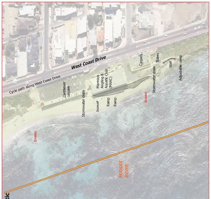
Appendix D.19.       Ledge Point

                             Figure D‐19: Ledge Point schematic

Assessment of Coastal Erosion Hotspots in WA 138                  Appendix D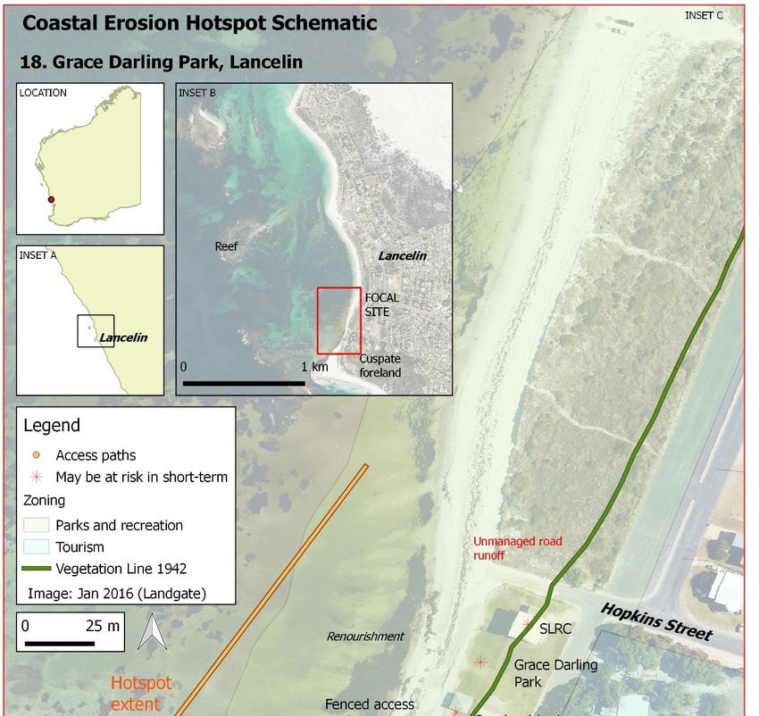
This hotspot profile must be read in conjunction with the Disclaimer on p.78 on the cover of Appendix D.
                             Table D‐19: Ledge Point summary information
 Hotspot No.              19
 Hotspot Name             Ledge Point
 Local Coastal Manager    Shire of Gingin
 Hotspot issue            The Ledge Point hotspot is on the southern side of the Ledge Reef salient, extending from
                          the southern groyne to the eastern end of De Burgh Street. The coast is susceptible to
                          storm erosion, variability in sediment supply and landform migration in the lee of the reef.
                          The town was established in 1955 for crayfishing following a history of camping and shacks.
                          As part of the town establishment the dunes along De Burgh Street were modified and
                          flattened to allow for residential development. The adjacent beach has required
                          management, with anecdotes of a timber seawall to protect properties, along with
                          installation of groynes in the 1970s and 1980s with associated renourishment. Storm
                          erosion is expected during periods of low sediment supply with partial recovery with
                          development of low foredunes. Wholescale retreat may occur due to reduced sediment
                          supply, with scarping of the embankments of private properties and increased
                          embaymentisation between reef and groyne features.

                          Four publicly owned assets may be at risk of erosion damage in the area (see attached
                          figure), two of which may be at risk in the short‐term. These include the Jones Street
                          vehicle access track (a sand ramp with bank stabilisation) and ten sand access tracks
                          (counted as one combined asset). In the medium‐ to longer‐term, a 10‐20m section of
                          Jones Street is also at risk and the De Burgh Street vehicle access ramp. Six private
                          properties may be at risk in the short‐term, increasing to 13 in the long term. Many of the
                          properties have private access to the beach which is considered uncontrolled access.
                          Recreational activities on the shore and in inshore waters include walking, swimming,
                          fishing, driving on beach and boat launching. The main non‐governmental stakeholders that
                          are likely to have an active interest in how this foreshore is managed include Ledge Point
                          Community Association and Ledge Point Coastcare Group.
 Extent of erosion        The south‐facing side of the salient extending east of the southern groyne to the eastern
 problem and hotspot      end of De Burgh Street.
 characteristics          Hotspot characteristics:
                          • Infrastructure close to the existing shore, or landward of progressively and rapidly eroding
                          coast (proximity).
                          • Typically subject to progressive or episodic erosion (instability).
                          • Very highly valued by the community, as nominated by local government (community).
 CHRMAP status and        CHRMAP Status: In Progress ‐ Final stages of CHRMAP recently awarded to Cardno. Draft
 findings                 report due July 2017. CMPAP funded.
                          Hazard Assessment: MRA (2016) ‐ Immediate risk of erosion identified (existing buffer
Assets susceptible to     4 public assets susceptible to erosion hazard. 20m of Jones Street, Jones St vehicle access
 erosion hazard in         track (sand ramp with bank stabilisation), De Burgh vehicle access track, 10 informal access
 Projected timeframe       tracks.
 (25+ years)
                           Private Properties: 13 properties on De Burgh Street
 Existing management       Avoid (Y ‐ some private properties on De Burgh Street have sufficient buffer to storm
                           erosion),
                           Retreat (N),
                           Accommodate (N),
                           Protect (Y ‐ some historic renourishment undertaken (1984), groyne at the point)
                           Note: The existing strategy does not provide protection to the private properties.
 Management options        Avoid (Y ‐ Some private properties (approx. 6 south west of number 23) on De Burgh Street
 for Imminent timeframe    have sufficient buffer to storm erosion),
 (0‒5 years)               Retreat (N),
                           Accommodate (Y ‐ dune fencing. Access control from individual properties. Drainage
                           management.),
                           Protect (N)
                           Preparation of planning frameworks for retreat in next level of management and identify
                           funding mechanisms.
 Approximation of cost     Avoid ‐ None
 for Imminent timeframe    Accommodate ‐ L
 (0‒5 years) options       Prepare Plans ‐ 50k
 (L/M/H)
 Trigger for next level    Trigger for next level management: Buffer width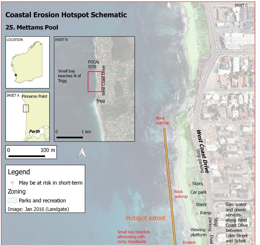
Appendix D.20.       Seabird Foreshore, Gingin

                       Figure D‐20: Seabird Foreshore, Gingin schematic

Assessment of Coastal Erosion Hotspots in WA 141                          Appendix D
This hotspot profile must be read in conjunction with the Disclaimer on p.78 on the cover of Appendix D.
                       Table D‐20: Seabird Foreshore, Gingin summary information
 Hotspot No.               20
 Hotspot Name              Seabird Foreshore, Gingin
 Local Coastal Manager     Shire of Gingin
 Hotspot issue             Seabird is located on an unstable salient with infrastructure located too close to the coast,
                           including private properties. Seabird is one of the coastal townsites based on squatters
                           shacks built on the top of the foredunes by lobster fishermen in the 1950’s and 1960's.
                           Freehold title was created towards the end of those decades. The Coastal Townsites
                           Committee of the then Town Planning Department recommended, in the early 1970's, that
                           Seabird should not be further developed, and should be limited to licensed fishermen only,
                           because of its vulnerability to erosion and wave action. A fuelling jetty was known to have
                           been destroyed in earlier years by storms and erosion. Turner Street was built on the
                           seaward face of the foredune, to provide vehicle access to the beach for the fishermen.

                           Erosion is due to instability of the salient from changing meteorologic and oceanic
                           conditions, varying sediment supply and potential downdrift erosion in part from natural
                           rock outcrops to the south. In recent years a number of erosion mitigation measures have
                           been undertaken to protect private properties including multiple renourishment
                           campaigns, installation of flexmat and a rock revetment in 2016. Armouring the foreshore is
                           likely to cause permanent loss of a beach in front of the revetment, and continued sand loss
                           at the ends of the revetment and further north. The erosion can be expected to continue
                           along the foreshore to the north for up to three times the length of the revetment.

                           Ten publicly owned assets may be at risk of erosion damage in the area and to the north
                           (see attached figure), with six assets at risk of damage in the short‐term, including beach
                           access paths, the Tulley View car park, boat ramp and stair access as well as the stair case
                           and boat ramp fronting the caravan park. The Tulley View car park, ramp and stair case
                           were installed in 2010. Thirteen private properties are located behind the revetment
                           constructed as short‐term emergency works and are at risk in the medium‐term and up to
                           17 private properties, including the caravan park (built strata titles) in the longer‐term. A
                           revetment was constructed in 2016 to protect the three cul de sacs and 15 private
                           properties in the short‐term, which has now been proposed to extend north to include the
                           Tulley View car park and stair case. The main recreational uses at the site are boat
                           launching, walking, swimming, fishing and dog exercise. Social pressures at this site relate
                           to maintaining the existing recreational uses as the beach is lost in front of the revetment,
                           and boat ramps, car parks and staircases are damaged to the north. There are multiple
                           community groups and residents with an active interest in the foreshore.
 Extent of erosion         The southern foreshore of the Cuspate foreland between the beach access in the N and to
 problem and hotspot       the south of the Bluewave seafood site
 characteristics           Hotspot characteristics:
                           • Infrastructure close to the existing shore, or landward of progressively and rapidly eroding
                           coast (proximity).
                           • Typically subject to progressive or episodic erosion (instability).
                           • Apparent costs of likely forms of erosion mitigation are high.
                           • Apparently limited capacity to manage future erosion using existing coastal protection
                           measures where extension of works is likely to exacerbate erosion transfer (transfer).
                           • Very highly valued by the community, as nominated by local government (community).
 CHRMAP status and         CHRMAP Status: In Progress ‐ Final stages of CHRMAP by Cardno
 findings                  Hazard Assessment: MRA (2016) ‐ Immediate risk of erosion identified (existing buffer
Coastal dynamics         Renourishment source, possibly geotechnical and ongoing coastal movement data
 studies for a level 3    collection
 assessment. Further
 detail in Table 4‐2.
 Assets susceptible to    4 public assets susceptible to erosion hazard. * 3 cul‐de‐sacs, boat ramp, *Tulley View car
 erosion hazard in        park and stair access, access paths
 Imminent timeframe (0‒
 5 years)                 Private property: *15 on McCormick and Turner Streets (cannot guarantee wall will provide
                          protection). Note: N boat ramp and stair access near caravan park is privately owned
 Assets susceptible to    8 public assets susceptible to erosion hazard. 3 cul‐de‐sacs, N stair access, boat ramp, Tulley
 erosion hazard in        View car park and stair access, car park, access paths
 Expected timeframe (5‒
 25 years)                Private property: 16 on McCormick and Turner Streets, including the Caravan Park (built
                          strata titles). Note: N boat ramp and stair access near caravan park is privately owned.
 Assets susceptible to    8 public assets susceptible to erosion hazard. 3 cul‐de‐sacs, boat ramp, Tulley View car park
 erosion hazard in        and stair access, car park, access paths, roads
 Projected timeframe
 (25+ years)              Private property: 17 on McCormick and Turner Streets, including the Caravan Park (built
                          strata titles). N boat ramp and stair access near caravan park is privately owned.
 Existing management      A protective seawall has recently been constructed and extended
                          Avoid (N),
                          Retreat (N),
                          Accommodate (N),
                          Protect (Y ‐ 2016 seawall with recent extension northwards)
 Management options       Anticipated behaviour: Loss of beach amenity is anticipated and erosion to transfer to
 for Imminent timeframe   north destabilising stairs and boat launching.
 (0‒5 years)              Avoid (N),
                          Retreat (Y ‐ stairs and boat ramp at Tulley View will now require partial retreat/construction
                          in this timeframe due to seawall extension N),
                          Accommodate (N),
                          Protect (Y‐ maintain existing wall. Already extended N in 2016 to Tulley View)
                          Preparation of planning frameworks for retreat in next level of management and identify
                          funding mechanisms.
                          Review strata agreements with caravan park to clarify responsibilities for coastal erosion
                          mitigation
 Approximation of cost    Retreat ‐ L
 for Imminent timeframe   Protect ‐ L
 (0‒5 years) options      Prepare Plans ‐ 50k
 (L/M/H)                  Review Strata Agreement ‐ 50k
 Trigger for next level   Trigger for next level management: Progressive erosion threatening beach access
 management,              structures to downdrift
 monitoring and           Monitoring: Beach width
 alternate management     Alternate option: N/A
 option (Imminent
 timeframe 0‒5 years)
 Management and           Anticipated behaviour: Coastal retreat is expected to continue, mainly transferring erosion
 adaptation options for   northwards. Loss of existing beach access points will occur due to local downdrift erosion.
 Expected timeframe (5‒   Erosion may impact caravan park in this timeframe.
 25 years)                Avoid (N),
                          Retreat (Y ‐ Relocate & redesign beach access points including boat access
                          (recommended)),
                          Accommodate (N),
                          Protect (Y ‐ (Option) to extend seawall further northwards)
                          Preparation of planning frameworks for retreat in next level of management and identify
                          funding mechanisms.
 Approximation of cost    Retreat ‐ M
 for Expected timeframe   Protect ‐ H
 (5‒25 years) options     Prepare plans ‐ 50k
 (L/M/H)

Assessment of Coastal Erosion Hotspots in WA 143                                                          Appendix D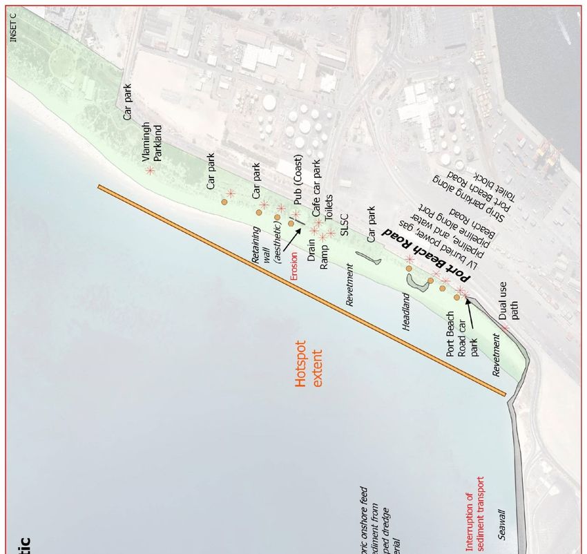
Trigger for next level    Trigger for next level management: Downdrift erosion due to walling providing acute
 management,               erosion threat to caravan park to the north
 monitoring and            Monitoring: Beach width
 alternate management      Alternate option: Retreat of strata properties at risk.
 option (Expected
 timeframe 5‒25 years)
 Management and            Anticipated behaviour: General coastal retreat expected
 adaptation options for    Avoid (N),
 Projected timeframe       Retreat (Y ‐ 17 private properties require consideration to maximise effective use of the
 (25+ years).              setback for the northern part of the town site. Relocate sections of the caravan park when
                           threatened by acute erosion hazard),
                           Accommodate (N),
                           Protect (Y ‐ Continue to maintain and deepen walling – may provide permission for private
                           landowners to undertake the works. Provide alongshore control structures to transfer
                           downdrift erosion issues away from town site.)
 Works to avoid to         No additional investment in coast infrastructure; Do not extend the town site north without
 achieve long‐term plans   substantial increase in coastal setbacks; Do not extend protection works until strictly
                           necessary; Avoid cross‐shore structures (e.g. headlands).
                           Use of protective works at Seabird is a balancing act. Low density private development is
                           being protected by reducing the effective erosion buffer for the higher density section of
                           the town to the north. A very high loss of beach amenity is expected.

Assessment of Coastal Erosion Hotspots in WA 144                                                        Appendix D
Appendix D.21. Two Rocks northern coast
Figure D‐21: Two Rocks northern coast schematic
Assessment of Coastal Erosion Hotspots in WA 145 Appendix DThis hotspot profile must be read in conjunction with the Disclaimer on p.78 on the cover of Appendix D.
Table D‐21: Two Rocks northern coast summary information
Hotspot No. 21
Hotspot Name Two Rocks northern coast
Local Coastal Manager City of Wanneroo
Hotspot issue The foreshore north of Two Rocks Marina, along Sovereign Drive, has progressively eroded
since the marina was constructed in 1973/1974. The erosion is due to an interruption of
sediment transport by the marina and transfer of erosion stress due to the breakwater. The
foreshore has eroded 100m of a 200m setback in approximately 40 years. There is natural
rock underlying the whole length of the housing development along Sovereign Drive,
although the level of erosion protection offered by this rock is not yet known.
Five publicly owned assets may be at risk of erosion damage in the area (see attached
figure); two of these assets, the Navigation Lead and a staircase for beach access, are at risk
of damage in the short‐term. In the longer‐term, more than 500m of Sovereign Drive and
its associated assets (critical water pipes, power, street lights) are high‐value assets that
may be at risk, along with the private properties on the landward side. Bush Forever Site
397 covers the foreshore area. This is a beach with moderate use that experiences periods
of restricted access following storms. The main recreational uses are walking, swimming
and fishing. There is limited community group pressure at the moment; however, this is
expected to increase as erosion progresses towards the road and during periods of
restricted beach access.
Extent of erosion North of Two Rocks Marina to the northern extent of Sovereign Drive
problem and hotspot Hotspot characteristics:
characteristics • Infrastructure close to the existing shore, or landward of progressively and rapidly eroding
coast (proximity).
• Typically subject to progressive or episodic erosion (instability).
• Apparently limited capacity to manage future erosion using existing coastal protection
measures where extension of works is likely to exacerbate erosion transfer (transfer).
CHRMAP status and CHRMAP Status: In Progress
findings Hazard Assessment: MRA (2015) ‐ Erosion risk identified in 30‐40 years
Management & Adaptation Options: Values assessment recently completed
Additional Comments: Not identified as a priority area in current CHRMAP (in‐progress)
Reports:
MRA (2015) CHRMAP Part 1 Coastal Vulnerability Study & Hazard Mapping. Prepared by MP
Rogers for the City of Wanneroo. Report R607, Rev. 1, Nov‐2015
Coastal dynamics Further geotechnical (if required) and ongoing coastal movement data collection
studies for a level 3
assessment. Further
detail in Table 4‐2.
Assets susceptible to 2 public assets susceptible to erosion hazard. 1 Navigation Lead 1 set of stairs for access.
erosion hazard in
Imminent timeframe (0‒ Note: Bush Forever Site 397
5 years)
Assets susceptible to 3 public assets susceptible to erosion hazard. Possible 50m of Sovereign Drive, Navigation
erosion hazard in Lead, 1 set of stairs.
Expected timeframe (5‒
25 years) Note: Bush Forever Site 397
Assets susceptible to 5 public assets susceptible to erosion hazard. >500m of Sovereign, Navigation Lead, 1 set of
erosion hazard in stairs and 1 parallel car park (both in the N).
Projected timeframe Services: water, power, street lights.
(25+ years)
Private property: 6 on Sovereign Drive.
Note: Bush Forever Site 397
Existing management Avoid (Y ‐ Downdrift buffer to development has been identified),
Retreat (N),
Accommodate (N),
Protect (N)
Assessment of Coastal Erosion Hotspots in WA 146 Appendix DManagement options Avoid (Y ‐ Downdrift buffer to development),
for Imminent timeframe Retreat (Y ‐ relocate beach access stairs),
(0‒5 years) Accommodate (N),
Protect (N)
Preparation of planning frameworks for retreat in next level of management and identify
funding mechanisms.
Approximation of cost Avoid ‐ None
for Imminent timeframe Retreat ‐ L
(0‒5 years) options Prepare Plans ‐ 50k
(L/M/H)
Trigger for next level Trigger for next level management: Buffer width and length is inadequate to provide
management, protection against moderate acute erosion.
monitoring and Monitoring: Buffer width, measured along the coast.
alternate management Alternate option: N/A
option (Imminent
timeframe 0‒5 years)
Management and Anticipated behaviour: Continued downdrift erosion will progressively remove the existing
adaptation options for buffer
Expected timeframe (5‒ Avoid (N),
25 years) Retreat (Y ‐ Navigation aid to be relocated),
Accommodate (N),
Protect (Y ‐ Construction of 'back‐up' seawall)
Approximation of cost Retreat ‐ L
for Expected timeframe Protect ‐ H
(5‒25 years) options
(L/M/H)
Trigger for next level Trigger for next level management: Exposure of back‐up seawall for >24 months (i.e.
management, inadequate natural recovery)
monitoring and Monitoring: Photographic monitoring
alternate management Alternate option: N/A
option (Expected
timeframe 5‒25 years)
Management and Anticipated behaviour: General coastal retreat and continued downdrift erosion will result
adaptation options for in loss of the existing buffer and pressure on existing facilities landward of the buffer
Projected timeframe Avoid (N),
(25+ years). Retreat (N),
Accommodate (N),
Protect (Y – Construct erosion mitigation structures (e.g. revetment), noting it will transfer
downdrift erosion pressure further along the coast)
Works to avoid to High value facilities west of Sovereign Drive, beach access installations capable of
achieve long‐term plans impounding sand, Northerly extension of Sovereign Drive development
Assessment of Coastal Erosion Hotspots in WA 147 Appendix DAppendix D.22. Quinns Beach
Figure D‐22: Quinns Beach schematic
Assessment of Coastal Erosion Hotspots in WA 148 Appendix DThis hotspot profile must be read in conjunction with the Disclaimer on p.78 on the cover of Appendix D.
Table D‐22: Quinns Beach summary information
Hotspot No. 22
Hotspot Name Quinns Beach
Local Coastal Manager City of Wanneroo
Hotspot issue Quinns Beach is located on the western side of a sandy foreland, and has experienced
erosion from the southern end of the sandy beach since before 1970. The site was originally
beach shacks, with ongoing development in proximity to the coast and increased
recreational use. Erosion at this site has been managed by a sequence of works including:
initial removal of beach cottages from the low dune area through to the headland; a
detached rock headland; groyne field; renourishment; and most recently a geotextile
seawall. A medium‐term plan is being developed by the City of Wanneroo with two options
released for public consultation. Erosion has been progressive, linked to landform response
to storminess and variability of available coastal sediments; with erosion pressures
transferred, primarily to the north, by protective works.
Twelve publicly owned assets may be at risk of erosion damage in the area (see attached
figure), with only two unprotected assets at risk of damage in the short‐term, being the car
park behind the tipped rock revetment and the seaward end of beach access paths. In the
longer‐term, Ocean Drive, the services under the roadway and private properties to
landward are high‐value assets at risk unless protective works are maintained or improved.
This is a highly valued recreational beach, with social pressure relating to maintaining
existing recreational use (swimming, walking, fishing, Fred Stubbs Park) and the car park. It
should be noted that protective engineering works have the potential to conflict with the
desire for a recreational beach, i.e. seawalls may cause loss of their fronting beach. Beach
use is focussed next to car parks and Fred Stubbs park. There are active community groups
and residents in the area.
Extent of erosion Tip of cuspate foreland to northern of the three groynes (western side of cuspate foreland)
problem and hotspot Hotspot characteristics:
characteristics • Infrastructure close to the existing shore, or landward of progressively and rapidly eroding
coast (proximity).
• Typically subject to progressive or episodic erosion (instability).
• Apparent costs of likely forms of erosion mitigation are high.
• Very highly valued by the community, as nominated by local government (community).
CHRMAP status and CHRMAP Status: In Progress
findings Hazard Assessment: Cardno (2015) ‐ Immediate risk of erosion identified (existing bufferAssets susceptible to 12 public assets susceptible to erosion hazard. Ocean Drive with services to landward,
erosion hazard in path, car park, Mary St access, Camira Way access at groyne, parallel parking along Ocean
Projected timeframe Drive, Fred Stubbs park, toilet block, playground, access paths.
(25+ years) Services: Gas, telecommunications and water.
Private properties: 15 on Ocean Drive
Note: Bush Forever Site 397.
Existing management Existing strategy is in the process of being implemented.
Avoid (N),
Retreat (N),
Accommodate (N),
Protect (Y ‐ Renourishment between the groynes. Rock groynes to reduce alongshore
transport loss. Recent construction of seawall)
Management options Avoid (N),
for Imminent timeframe Retreat (Y ‐ Relocate carpark),
(0‒5 years) Accommodate (N),
Protect (Y ‐ Rock groynes (new groyne). Maintain seawall)
Preparation of planning frameworks for retreat in next level of management and identify
funding mechanisms.
Approximation of cost Retreat ‐ M
for Imminent timeframe Protect ‐ M
(0‒5 years) options Prepare Plans ‐ 50k
(L/M/H)
Trigger for next level Trigger for next level management: Facilities threatened by acute erosion following
management, progressive retreat.
monitoring and Monitoring: Buffer width
alternate management Alternate option: N/A
option (Imminent
timeframe 0‒5 years)
Management and Anticipated behaviour: Progressive general retreat will not be wholly halted by groynes,
adaptation options for but will result in rotation, with erosion on the northern side of the groynes. Downdrift
Expected timeframe (5‒ erosion likely highest at northern end of groyne field.
25 years) Avoid (N),
Retreat (Y ‐Remove remaining facilities seaward of Ocean Drive, including park, playground,
toilet block),
Accommodate (N),
Protect (Y ‐ some renourishment for emergency response. Renourishment focused for
amenity at ongoing high cost. Maintain rock groynes)
Approximation of cost Retreat ‐ M
for Expected timeframe Protect ‐ H
(5‒25 years) options
(L/M/H)
Trigger for next level Trigger for next level management: Ocean Drive threatened by acute storm erosion
management, following continued retreat.
monitoring and Monitoring: Buffer width
alternate management Alternate option: N/A
option (Expected
timeframe 5‒25 years)
Management and Anticipated behaviour: Long‐term retreat (and continued rotation) will threaten sections of
adaptation options for Ocean Drive.
Projected timeframe Avoid (N),
(25+ years). Retreat (N),
Accommodate (N),
Protect (Y ‐ Provide seawall structure to protect Ocean Drive)
Works to avoid to High value or long‐term facilities seaward of Ocean Drive, ‘infill’ development near Camira
achieve long‐term plans Way
Assessment of Coastal Erosion Hotspots in WA 150 Appendix DAppendix D.23. MAAC Seawall, Joondalup
Figure D‐23: MAAC Seawall, Joondalup schematic
Assessment of Coastal Erosion Hotspots in WA 151 Appendix DThis hotspot profile must be read in conjunction with the Disclaimer on p.78 on the cover of Appendix D.
Table D‐23: MAAC Seawall, Joondalup summary information
Hotspot No. 23
Hotspot Name MAAC Seawall, Joondalup
Local Coastal Manager City of Joondalup
Hotspot issue The Marmion Angling and Aquatic Club (MAAC) has been in its present location since the
1950s when it transitioned from fishing shacks to a leasehold club. The club is built on a
small perched beach on a rocky coast, fronted by a rock revetment. The site is susceptible
to damage during periods of severe storm activity, with many assets protected by existing
seawalls, and is under threat from projected sea level rise. The car park to the north was
upgraded in 2015 to accommodate the increase in beach use in the area.
Ten publicly owned assets may be at risk of erosion damage in the area (see attached
figure), two of which are not protected by seawalls and are at risk of damage in the short‐
term, including the northern access point from the northern carpark and the adjustable
ramp to south. In the longer term, West Coast Drive, services under the road, stormwater
drains and the leasehold MAAC building and access ramps are high‐value assets at risk. This
is a high recreational use site with MAAC activities, swimming and parking. The MAAC
represent a local stakeholder group with a large membership base.
Extent of erosion Car park N of Marmion Angling and Aquatic Club to the toilet block at the S
problem and hotspot Hotspot characteristics:
characteristics • Infrastructure close to the existing shore, or landward of progressively and rapidly eroding
coast (proximity).
• Apparently limited capacity to manage future erosion using existing coastal protection
measures where extension of works is likely to exacerbate erosion transfer (transfer).
• Very highly valued by the community, as nominated by local government (community).
CHRMAP status and CHRMAP Status: Not Scheduled
findings Hazard Assessment: MRA (2011) ‐ Erosion risk dependent on integrity of existing seawall
Management & Adaptation Options: Nil
Additional Comments: MRA (2011) identified that the existing seawall is only in
'reasonable' condition.
Reports:
MRA (2011) Marmion ‐ Sorrento Coastal Protection Study. Prepared by MP Rogers and
Associates for City of Joondalup. Report R284, Rev 1, May‐2011.
Coastal dynamics Possibly geotechnical and ongoing coastal movement data collection
studies for a level 3
assessment. Further
detail in Table 4‐2.
Assets susceptible to 4 public assets susceptible to erosion hazard. N access path from N car park, adjustable
erosion hazard in ramp at S end, two leasehold MAAC access ramps
Imminent timeframe (0‒
5 years) Leasehold: two MAAC access ramps.
Assets susceptible to 7 to 9 public assets susceptible to erosion hazard. 2 fixed access paths from N car park (N
erosion hazard in and S ends), *S access path from toilet block to beach, adjustable ramp at S end, cantilever
Expected timeframe (5‒ carpark [check foundations], *S carpark (lower) on rock, two leasehold MAAC access ramps,
25 years) leasehold MAAC building
Leasehold: two MAAC access ramps and MAAC building.
Assets susceptible to 13 public assets susceptible to erosion hazard. *West Coast Drive, cycle path, 2 fixed access
erosion hazard in paths from N car park (N and S ends), *S access path from toilet block to beach, adjustable
Projected timeframe ramp at S end, cantilever carpark [check foundations], *S carpark (lower) on rock, *toilet
(25+ years) block on rock, two leasehold MAAC access ramps, leasehold MAAC building
Services: Gas, power, water, and 2 stormwater drains.
Leasehold: two MAAC access ramps and MAAC building.
Existing management Avoid (N),
Retreat (N),
Accommodate (N),
Protect (Y ‐ Seawall constructed in front of building and carpark)
Assessment of Coastal Erosion Hotspots in WA 152 Appendix DManagement options Avoid (N),
for Imminent timeframe Retreat (N),
(0‒5 years) Accommodate (N),
Protect (Y ‐ Maintain seawall in front of building and S carpark)
Review lease agreements with MAAC to clarify responsibilities for coastal erosion mitigation
Approximation of cost Protect ‐ L
for Imminent timeframe Review Lease Agreement ‐ 50k
(0‒5 years) options
(L/M/H)
Trigger for next level Trigger for next level management: Damage to seawall
management, Monitoring: Annual structural inspection of seawall
monitoring and Alternate option: N/A
alternate management
option (Imminent
timeframe 0‒5 years)
Management and Anticipated behaviour: Structural degradation of seawall will occur over time, amplified by
adaptation options for increasing sea level
Expected timeframe (5‒ Avoid (N),
25 years) Retreat (N),
Accommodate (N),
Protect (Y ‐Strengthening of seawall and modification to reduce wave overtopping likely to
be required)
Preparation of planning frameworks for retreat in next level of management and identify
funding mechanisms.
Approximation of cost Protect ‐ M
for Expected timeframe Prepare plans ‐ 50k
(5‒25 years) options
(L/M/H)
Trigger for next level Trigger for next level management: End of structure life or lease
management, Monitoring: Structural assessment of building every 5‐10 years.
monitoring and Alternate option: N/A
alternate management
option (Expected
timeframe 5‒25 years)
Management and Avoid (N),
adaptation options for Retreat (Y ‐ Remove all facilities and services at the end of the building’s structural life or
Projected timeframe lease, whichever comes first. It is worth considering reconstructing facilities on the same
(25+ years). location with narrower footprint and further landward with more accommodation
measures),
Accommodate (N),
Protect (N)
Works to avoid to Structural renovation or extension of the building
achieve long‐term plans
Assessment of Coastal Erosion Hotspots in WA 153 Appendix DAppendix D.24. Waterman’s Bay, Stirling
Figure D‐24: Waterman’s Bay, Stirling schematic
Assessment of Coastal Erosion Hotspots in WA 154 Appendix DThis hotspot profile must be read in conjunction with the Disclaimer on p.78 on the cover of Appendix D.
Table D‐24: Waterman’s Bay, Stirling summary information
Hotspot No. 24
Hotspot Name Watermans Bay, Stirling
Local Coastal Manager City of Stirling
Hotspot issue Watermans Beach is a pocket sandy beach and foredune overlying a rock pavement, which
has been a site of erosion pressure for more than a decade. Facilities have been established
at this site too close to the shoreline with ongoing encroachment as the road and path have
been widened. A geosynthetic sand container seawall was constructed in 2010 as an
emergency management measure following the 2009 storms, which is subject to vandalism
and likely to have a short design life. As Watermans is a pocket beach, permanent reflective
seawalls are likely to cause the beach to lose its sand, which is the asset for which the
public facilities have been built. Some monitoring programs have been undertaken, with
further understanding required on the underlying rock stratigraphy and its impact on post‐
storm recovery and stability of the assets.
Fourteen publicly owned assets may be at risk of erosion damage in the area (see attached
figure), three of which are at risk of damage in the short‐term, including two staircases and
a drain. In the longer term, if projected sea level rise occurs, West Coast Highway,
associated services (power, water, communications fibre) and private properties along
West Coast Highway and Mary Street are high‐value assets at risk. The high‐use site is
valued for swimming, snorkelling and surfing.
Extent of erosion Watermans Bay beach along West Coast Drive between Beach Road and south of Mary
problem and hotspot Street
characteristics Hotspot characteristics:
• Infrastructure close to the existing shore, or landward of progressively and rapidly eroding
coast (proximity).
• Typically subject to progressive or episodic erosion (instability).
• Apparent costs of likely forms of erosion mitigation are high.
• Apparently limited capacity to manage future erosion using existing coastal protection
measures where extension of works is likely to exacerbate erosion transfer (transfer).
• Very highly valued by the community, as nominated by local government (community).
CHRMAP status and CHRMAP Status: Not Scheduled
findings Hazard Assessment: Nil
Management & Adaptation Options: Nil
Additional Comments: Seawall exists protecting a portion of the site.
Reports:
BMT JFA produced a report in 2015 on a strategic coastal study solely funding by the City of
Stirling. Not reviewed.
UWA (2006) Coastal Foreshore Action Plan Trigg Point to Watermans Bay. Prepared by
Institute for Regional Development School of Earth and Geographical Sciences University of
Western Australia prepared for City of Stirling. May‐2006
SKM (2004) Coastal Hazard Remediation: Geotechnical Assessment. Prepared by SKM
Consulting for the City of Stirling.
Coastal dynamics Possible geotechnical and ongoing coastal movement data collection
studies for a level 3
assessment. Further
detail in Table 4‐2.
Assets susceptible to 3 public assets susceptible to erosion hazard. 2 stairs access.
erosion hazard in Services: Drain
Imminent timeframe (0‒
5 years)
Assets susceptible to 9 public assets susceptible to erosion hazard. 3 stairs access, 3 outlooks from path with
erosion hazard in seating/shower, toilet block.
Expected timeframe (5‒ Services: drain
25 years)
Assets susceptible to 14 public assets susceptible to erosion hazard. West Coast Drive parallel to coast, cycle path
erosion hazard in with lights, 3 outlooks from path with seating/shower/powerbox, 4 stairs access, strip
Projected timeframe parking both sides of West Coast Drive, toilet block,
(25+ years) Services: Power, water, fibre, drain.
Private property:11 on West Coast Drive (including 2 vacant lots) and Mary Street
Assessment of Coastal Erosion Hotspots in WA 155 Appendix DExisting management Avoid (N),
Retreat (N),
Accommodate (N),
Protect (Y ‐Geosynthetic sand container revetment)
Management options Avoid (N),
for Imminent timeframe Retreat (N),
(0‒5 years) Accommodate (N),
Protect (Y ‐ Maintain GSC revetment)
Prepare plans to implement retreat for next level of management and identify funding
mechanisms.
Approximation of cost Protect ‐ L (if storms)
for Imminent timeframe Prepare Plans ‐ 50k
(0‒5 years) options
(L/M/H)
Trigger for next level Trigger for next level management: GSC revetment reaching end of functional life (>5%
management, damage per annum)
monitoring and Monitoring: Annual structural inspection of GSC revetment
alternate management Alternate option: N/A
option (Imminent
timeframe 0‒5 years)
Management and Avoid (N),
adaptation options for Retreat (Y ‐ Remove toilet block),
Expected timeframe (5‒ Accommodate (N),
25 years) Protect (Y ‐ Replace GSC revetment with high rock revetment tie‐in to rock and beach
renourishment for amenity. High cost for maintenance of beach)
Prepare plans to implement retreat for next level of management and identify funding
mechanisms.
Approximation of cost Retreat ‐ L
for Expected timeframe Protect ‐ H
(5‒25 years) options Prepare plans ‐ 50k
(L/M/H)
Trigger for next level Trigger for next level management: Underground services reaching end of functional life.
management, Monitoring: Not required
monitoring and Alternate option: Install groynes to reduce beach mobility and renourish beach
alternate management
option (Expected
timeframe 5‒25 years)
Management and Avoid (N),
adaptation options for Retreat (Y ‐ Any opportunity to relocate the underground services to a less coastal position
Projected timeframe should be taken),
(25+ years). Accommodate (N),
Protect (Y ‐ Maintain rock revetment
Option: Install groynes to reduce beach mobility and renourish beach)
Works to avoid to Renewal of underground services in the same location; Any high value or long‐life assets
achieve long‐term plans landward of West Coast Drive
Assessment of Coastal Erosion Hotspots in WA 156 Appendix DAppendix D.25. Mettams Pool
Figure D‐25: Mettams Pool schematic
Assessment of Coastal Erosion Hotspots in WA 157 Appendix DThis hotspot profile must be read in conjunction with the Disclaimer on p.78 on the cover of Appendix D.
Table D‐25: Mettams Pool summary information
Hotspot No. 25
Hotspot Name Mettams Pool
Local Coastal Manager City of Stirling
Hotspot issue Mettams Pool is one of a series of small bay beaches along West Coast Drive, located
between the rock outcrops at the south of the beach to the rock outcrop north of the car
park. Fringing reef sits just offshore at about mean sea level. Sand supply to the beaches is
principally from inshore bioproduction or alongshore sediment transport from offshore
pathways. Sediment loss from the beaches, through episodic storm attack, can lead to
increased embaymentisation. The coast road is a major tourism corridor used for walking,
cyclking and vehicular traffic, widened seawards to allow pavement, parking and walkway
thatwhich also acts as a distributor route providing direct frontage access to high‐value
residential subdivision. Present management includes dune reshaping and planting, and a
minor amount of protection of coastal paths. Geotechnical investigations have recently
been undertaken to design a longer‐term solution for erosion at the site.
Twenty‐two publicly owned assets may be at risk of erosion damage in the area (see
attached figure), 10 of which may be at risk in the short‐term. These include two universal
access ramps, a shade structure, four sets of stairs, dual‐use path, one viewing platform and
a pedestrian access ramp. In the medium‐ to longer‐term additional public assets that may
be at risk include more of the dual use path, section of West Coast Drive and associated
services (gas, power, water), two extra viewing platforms, the car park to the north, strip
parking and a grassed park area. This is a high use recreation site with board riding,
snorkelling, diving, swimming, exercise (walking and running) and beach photography. The
Stirling Natural Environment Coastcare is the main non‐government organisation likely to
have an active interest in how this foreshore is managed.
Extent of erosion Small bay beaches along West Coast Drive between the rock outcrops at the south of the
problem and hotspot beach to the rock outcrop north of the car park.
characteristics Hotspot characteristics:
• Infrastructure close to the existing shore, or landward of progressively and rapidly eroding
coast (proximity).
• Typically subject to progressive or episodic erosion (instability).
• Apparent costs of likely forms of erosion mitigation are high.
• Very highly valued by the community, as nominated by local government (community).
CHRMAP status and CHRMAP Status: Not Scheduled
findings Hazard Assessment: Nil
Management & Adaptation Options: Identified as a critical at risk area by the City of
Stirling.
Additional Comments: Nil
Reports:
BMT JFA produced a report in 2015 on a strategic coastal study solely funding by the City of
Stirling. Not reviewed.
UWA (2006) Coastal Foreshore Action Plan Trigg Point to Watermans Bay. Prepared by
Institute for Regional Development School of Earth and Geographical Sciences University of
Western Australia prepared for City of Stirling. May‐2006
SKM (2004) Coastal Hazard Remediation: Geotechnical Assessment. Prepared by SKM
Consulting for the City of Stirling.
Coastal dynamics Possibly renourishment source and ongoing coastal movement data collection. Possibly
studies for a level 3 geotechnical.
assessment. Further
detail in Table 4‐2.
Assets susceptible to 11 public assets susceptible to erosion hazard. 2 universal access ramps, shade structure
erosion hazard in within ramp, 4 stairs access, 45m of DUP, 1 viewing platforms, access ramp.
Imminent timeframe (0‒ Services: Drain.
5 years)
Assets susceptible to 15 public assets susceptible to erosion hazard. 2 universal access ramps, shade structure
erosion hazard in within ramp, 4 stairs access, 110m of DUP, 30m of West Coast Drive, 2 viewing platforms,
Expected timeframe (5‒ access ramp, carpark to N, 55m of strip parking.
25 years) Services: Drain.
Assessment of Coastal Erosion Hotspots in WA 158 Appendix DAssets susceptible to 23 public assets susceptible to erosion hazard. 2 universal access ramps, shade structure
erosion hazard in within ramp, 4 stairs access, grassed area, 160m of DUP, 120m of West Coast Drive, 4
Projected timeframe viewing platforms, access ramp, carpark to N, 80m of strip parking, 40m DUP (secondary), 1
(25+ years) strip parking bay.
Services: All between Giles and Scholl St, 100PVC gas pipeline, LV overhead powerline,
205CI water pipes, drain
Existing management Avoid (N),
Retreat (N),
Accommodate (Y ‐ some dune reshaping and planting),
Protect (N ‐ minor protection of paths)
Management options Anticipated behaviour: Beach access points threatened by storm erosion.
for Imminent timeframe Avoid (N),
(0‒5 years) Retreat (N),
Accommodate (Y ‐ strengthen dune protection at toilet block and path to N),
Protect (N)
Preparation of planning frameworks for retreat in next level of management and identify
funding mechanisms.
Approximation of cost Accommodate ‐ L
for Imminent timeframe Prepare Plans ‐ 50k
(0‒5 years) options
(L/M/H)
Trigger for next level Trigger for next level management: Within 0.5m level (vertically) of undermining
management, foundations of existing facilities.
monitoring and Monitoring: Critical levels measured relative to structures; Photographic record
alternate management Alternate option: Accommodate ‐ modify beach access. Renourishment could be
option (Imminent considered for amenity (not protection) if beach is eroded to underlying rock.
timeframe 0‒5 years)
Management and Anticipated behaviour: Erosion threatens to undermine existing facilities.
adaptation options for Avoid (N),
Expected timeframe (5‒ Retreat (Y ‐ relocate amenities / toilet blocks (any structures not founded on rock)),
25 years) Accommodate (Y ‐ realign seaward end of beach access points),
Protect (N)
Preparation of planning frameworks for retreat in next level of management and identify
funding mechanisms.
Approximation of cost Retreat ‐ M
for Expected timeframe Accommodate ‐ L
(5‒25 years) options Prepare plans ‐ 50k
(L/M/H)
Trigger for next level Trigger for next level management: Existing facilities undermined.
management, Monitoring: Visual assessment
monitoring and Alternate option: Renourishment could be considered for amenity (not protection) if beach
alternate management is eroded to underlying rock.
option (Expected Protect ‐ offshore breakwater construction (offshore from amenities) ‐ strongly not
timeframe 5‒25 years) recommended.
Management and Anticipated behaviour: Erosion compromises structural integrity of existing facilities.
adaptation options for Avoid (N),
Projected timeframe Retreat (Y ‐ Retreat the dual use path (e.g. concurrently retreat West Coast Highway by
(25+ years). rerouting to a one way road), relocate all amenities not founded on rock),
Accommodate (N),
Protect (Y ‐ foundation walling for parts of West Coast Drive may be considered; reinforce
underlying rock if exposed; renourish if all sand lost)
Works to avoid to Rebuilding toilet block. Allowing high value leasehold/development seaward of West Coast
achieve long‐term plans Highway or further seaward than the existing development east of west coast drive, to
allow for some change in road alignment/width.
Assessment of Coastal Erosion Hotspots in WA 159 Appendix DAppendix D.26. Floreat Beach
Figure D‐26: Floreat Beach schematic
Assessment of Coastal Erosion Hotspots in WA 160 Appendix DThis hotspot profile must be read in conjunction with the Disclaimer on p.78 on the cover of Appendix D.
Table D‐26: Floreat Beach summary information
Hotspot No. 26
Hotspot Name Floreat Beach
Local Coastal Manager Town of Cambridge
Hotspot issue Floreat Beach is a recreational beach located in a source area for sediment moving
northwards along the coast. Floreat has a history of intermittent erosion, partly in response
to installation of two groynes to the south at City Beach. The original surf lifesaving club
(SLSC) rooms were constructed in 1948 and moved seaward in 1962 following beach
accretion associated with construction of Floreat groyne. A road and two SLSC rooms have
been lost to erosion, most recently during Tropical Cyclone Alby in 1978. Existing public
assets are vulnerable to storm wave erosion, and the low elevation of the dune means that
some recreational assets may be severely damaged if a major storm occurs at the same
time as high tide. Past management actions have included moving the SLSC rooms landward
and north in 1981, and landward movement of the coastal road, partially converted to a car
park, in 1974 and 1978. Aerial imagery indicates renourishment was associated with groyne
construction, along with dune reshaping and planting.
Fourteen publicly owned assets may be at risk of erosion damage in the area (see attached
figure), nine of which may be at risk in the short‐term. This includes three fenced paths, a
sandy vehicle access ramp, a grassed park area, a shaded café area, a playground, a viewing
platform and Challenger Parade carpark which is within 17m of the dune toe. In the longer‐
term, five additional public assets are at risk including BBQs and picnic tables within the
park, the boardwalk between car parks, and gas and power lines to the Floreat SLSC. At this
timeframe Bush Forever Area 310 may also be at risk. The Floreat SLSC, the Floreat SLSC
storage shed, and the Kiosk at Floreat Beach are leasehold assets at risk in the medium to
longer‐term. Floreat has amenities set close to shore for convenience of the visitors to the
coast. A high number of users visit Floreat for many coastal based activities, including
swimming, surfing, fishing, beach games, SLSC activities, sunbathing, and exercise.
Extent of erosion Floreat beach from the southern extent of Challenger Parade car park to the vehicle access
problem and hotspot rank in the north.
characteristics Hotspot characteristics:
• Infrastructure close to the existing shore, or landward of progressively and rapidly eroding
coast (proximity).
• Typically subject to progressive or episodic erosion (instability).
• Apparent costs of likely forms of erosion mitigation are high.
• Very highly valued by the community, as nominated by local government (community).
CHRMAP status and CHRMAP Status: Not Scheduled
findings Hazard Assessment: MRA (2012) ‐ Erosion risk identified by 2022
Management & Adaptation Options: MRA (2012) recommends managed retreat for the car
park.
Additional Comments: Nil
Reports:
MRA (2012) Coastal Processes & Vulnerability Assessment. Prepared by MP Rogers and
Associates for the Town of Cambridge. Report R329, Rev. A, Nov‐2012
Coastal dynamics Possibly renourishment source and ongoing coastal movement data collection
studies for a level 3
assessment. Further
detail in Table 4‐2.
Assets susceptible to 9 public assets susceptible to erosion hazard. 3 fenced paths, sandy vehicle access ramp,
erosion hazard in grassed park area, shaded café area, playground, viewing platform, Challenger Parade
Imminent timeframe (0‒ carpark
5 years) Note: Bush Forever Area 310
Assets susceptible to 13 public assets susceptible to erosion hazard. Challenger Parade carpark, 3 fenced paths,
erosion hazard in sandy vehicle access ramp, grassed park area, BBQs, picnic benches, shaded café area,
Expected timeframe (5‒ playground, viewing platform, Floreat SLSC building, kiosk cafe building
25 years) Leasehold: Floreat SLSC and Kiosk cafe
Note: Bush Forever Area 310
Assessment of Coastal Erosion Hotspots in WA 161 Appendix DAssets susceptible to 17 public assets susceptible to erosion hazard. Boardwalk between carparks, Challenger
erosion hazard in Parade carpark, 3 fenced paths, sandy vehicle access ramp, grassed park area, BBQs, picnic
Projected timeframe benches, shaded café area, playground, viewing platform, Floreat SLSC building, Floreat
(25+ years) SLSC storage shed, kiosk cafe building
Services: 40PVC 70kPa gas line to Floreat SLSC, LV buried cable to SLSC
Leasehold: Floreat SLSC, Floreat SLSC storage shed and Kiosk cafe
Note: Bush Forever Area 310
Existing management Existing behaviour: The original SLSC club rooms were constructed in 1948 and moved
seaward in 1962 following beach accretion associated with construction of Floreat groyne
and renourishment. Floreat groyne to the south contributes to erosion, and efforts to
protect the 1962 clubrooms post‐Alby failed
Avoid (N),
Retreat (Y ‐ SLSC club rooms moved landward and north in 1981 (damaged TC Alby 1978),
coastal road (converted to carpark) moved landward in 1974/78),
Accommodate (Y ‐ some dune reshaping and planting),
Protect (Y ‐ renourishment associated with groyne construction)
Management options Anticipated behaviour: Storm erosion capable of undermining carpark & affecting building.
for Imminent timeframe Avoid (N),
(0‒5 years) Retreat (Y ‐ car park realignment (i.e. move landward approx. 10m). Note plan to be
prepared for alternate location of facilities),
Accommodate (Y ‐ dune rebuilding and fencing to limit vehicles driving along foredune (e.g.
a few rocks to divert traffic lower). Improve surface runoff management from car park to
avoid dune damage),
Protect (N)
Preparation of planning frameworks for retreat in next level of management and identify
funding mechanisms.
Review lease agreements with SLSC and kiosk to clarify responsibilities for coastal erosion
mitigation
Approximation of cost Retreat ‐ L
for Imminent timeframe Accommodate ‐ M
(0‒5 years) options Prepare Plans ‐ 50k
(L/M/H) Review Lease Agreement ‐ 50k
Trigger for next level Trigger for next level management: Threat to café building, with bufferWorks to avoid to Limit upgrading of café/SLSC.
achieve long‐term plans Avoid erosion mitigation structures.
Avoid more access locations.
Assessment of Coastal Erosion Hotspots in WA 163 Appendix DAppendix D.27. Port Beach
Figure D‐27: Port Beach schematic
Assessment of Coastal Erosion Hotspots in WA 164 Appendix DThis hotspot profile must be read in conjunction with the Disclaimer on p.78 on the cover of Appendix D.
Table D‐27: Port Beach summary information
Hotspot No. 27
Hotspot Name Port Beach
Local Coastal Manager Fremantle Ports & City of Fremantle
Hotspot issue Port Beach is a shore modified by harbour works and subsequently by rock revetments and
sea walls. The sandy beach had previously accreted from sand dredged from Fremantle
harbour, dumped offshore and then brought inland and northward by natural wave action
(DPI 2004). Several interruptions have changed the alignment of this beach, including
progressive extension of Rous Head. It is believed the offshore stockpile of dredged
material is no longer available to replenish this beach. The beach is not yet stabilised in
response to these changes and is vulnerable to erosion when sand is eroded during major
storms. High‐investment developments, including the Coast leasehold venue, have been
located on a low foredune. These developments are vulnerable to damage as the beach
responds to reduced sand supply and is susceptible to major storms, such as occurred in
May 2003. As the beach alignment shifts it is expected the northern salient will continue to
exist as a landform feature. Fremantle Port Authority undertake offshore profile monitoring
at the site to determine the impact of the Rous Head extension.
Management actions have included previous retreat of the southern car park, rock
revetments, sea walls, beach renourishment and dune restoration. The extent of any
seawall construction in front of assets is not well documented. Rock from older seawalls
and reclamation is regularly uncovered during lower beach levels, most recently in late
2016. Exposure of contaminated material, including asbestos, requires mitigation and
management along with erosion.
Twenty eight publicly owned assets may be at risk of erosion damage (see attached figure),
16 of which may be at risk in the short‐term. In the short‐term the public assets susceptible
to erosion hazard are 60m of dual use path, Port Beach Road carpark, 10 fenced access
tracks, one bitumen ramp access for SLSC activities, a toilet block, a drain and the Vlamingh
Parkland. In the longer‐term, an additional 12 public assets may be at risk, including 800m
of Port Beach Road, an extra 1km of dual use path (two separate sections), strip parking,
two car parks, a bitumen car park and sand car park to the north, Leighton Beach Boulevard
car park, and services (power, gas and water along Port Beach Road). The leasehold venue
Coast (current lease expires in 2025) is at risk in the short‐term with the Fremantle SLSC
rooms (current lease expires 2020) at risk in the medium‐term. Ownership of both buildings
revert to the landowner (Government of Western Australia) at the termination of the lease
agreements. Recreational use of this foreshore includes swimming, wind‐surfing, kite
surfing, sunbathing, exercising and activities related to the SLSC. The main non‐
governmental stakeholders that are likely to have an active interest in how this foreshore is
managed include Friends of Fremantle Beaches, the North Fremantle Community
Association Precinct 12, and the Port Beach Polar Bears. The City of Fremantle also work
with the Perth NRM Coastal and Marine Program to facilitate community engagement in
coastal conservation within coastal reserves.
Extent of erosion Port Beach along Port Beach Road between the northern extent of the Port Beach seawall
problem and hotspot and Walter Place.
characteristics Hotspot characteristics:
• Infrastructure close to the existing shore, or landward of progressively and rapidly eroding
coast (proximity).
• Typically subject to progressive or episodic erosion (instability).
• Apparently limited capacity to manage future erosion using existing coastal protection
measures where extension of works is likely to exacerbate erosion transfer (transfer).
• Very highly valued by the community, as nominated by local government (community).
CHRMAP status and CHRMAP Status: In Progress. Draft report due by May 2017. CMPAP funded
findings Hazard Assessment: GHD 2016 Port Beach assets identified at extreme risk by 2030.
Management & Adaptation Options: The City of Fremantle and the Town of Mosman Park
are in the process of completing a CHRMAP
Additional Comments: Nil
Reports: Draft Port, Leighton and Mosman Beaches Coastal Adaptation Plan
Nil
Assessment of Coastal Erosion Hotspots in WA 165 Appendix DYou can also read