Appendix J: Transportation Assessment Carriageway Consulting - Central Otago District Council
←
→
Page content transcription
If your browser does not render page correctly, please read the page content below

Appendix J:

Transportation Assessment

Carriageway Consulting

   Project: 56 Worcester Boulevard | Reference: |   /

Proposed Private Plan Change
               Shannon Farm
                    Cromwell

      Transportation Assessment
Table of Contents

Main Report                                                                                        Page
 1        Introduction                                                                                1
 2        Site Overview                                                                               2
          2.1      Location                                                                           2
          2.2      Road Hierarchy                                                                     3
 3        Current Transportation Networks                                                             4
          3.1      Roading Network                                                                    4
          3.2      Non-Car Infrastructure                                                             5
          3.3      Future Changes                                                                     5
 4        Current Transportation Patterns                                                             6
          4.1      Traffic Flows                                                                      6
          4.2      Non-Car Modes of Travel                                                            8
          4.3      Road Safety                                                                        8
 5        Proposal                                                                                    9
 6        Traffic Generation and Distribution                                                        10
          6.1      Traffic Generation                                                                10
          6.2      Trip Distribution                                                                 10
 7        Effects on the Transportation Networks                                                     11
          7.1      Intersection Capacity                                                             11
          7.2      Non-Car Modes of Travel                                                           12
          7.3      Road Safety                                                                       12
          7.4      Ripponvale Road Upgrading                                                         13
 8        Statutory Framework                                                                        14
          8.1      Introduction                                                                      14
          8.2      Otago Regional Land Transport Plans 2015-2021                                     14
          8.3      Otago Regional Public Transport Plan 2014                                         14
          8.4      Central Otago District Plan                                                       14
          8.5      Council’s Engineering Code of Practice                                            16
          8.6      Summary                                                                           16
 9        Conclusions                                                                                17

Photographs
 1        Ripponvale Road Looking West, Towards Site                                                  4
 2        Aerial Photograph of State Highway 6 / Ripponvale Road Intersection                         5
3/4       Sight Distances to the Left and Right at State Highway 6 / Ripponvale Road                  5
          Intersection

New Zealand Cherry Corp (Leyser) LP Limited                         Proposed Rural Residential Plan Change
Figures
 1        General Location of Development Site                                                        2
 2        Aerial Photograph of Development Site and Environs                                          2
 3        Traffic Flows on State Highway 6                                                            6
 4        Existing Peak Hour Traffic Flows at the State Highway 6 / Ripponvale Road                   7
          Intersection
 5        Annotated Proposed Structure Plan (Extract from Rough and Milne Drawing                     9
          ‘Structure Plan’ Numbered L1.1 Rev 0
 6        Traffic Generation Due to Development of Plan Change Site at the State                     10
          Highway 6 / Ripponvale Road Intersection
 7        Sight Distance Towards the East at the Proposed Site Access                                12
 8        Sight Distance Towards the West at the Proposed Site Access                                12

Tables
 1        Extract from Table 6.1 of Austroads Guide to Traffic Management Part 3                      7
          (Intersection Volumes below which Capacity Analysis is Unnecessary)
 2        Performance of State Highway 6 / Ripponvale Road with Full Development of                  11
          Plan Change Site
 3        Performance of State Highway 6 / Ripponvale Road with Full Development of                  11
          Plan Change Site, Highway Traffic Factored

CCL file reference        14470 ripponvale ta final
Status                    Final2
Issued                    23 May 2019

New Zealand Cherry Corp (Leyser) LP Limited                         Proposed Rural Residential Plan Change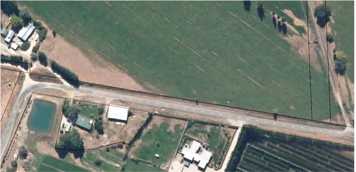
P.   1 / 17

1.      Introduction
1.1.    New Zealand Cherry Corp (Leyser) LP Limited proposes to lodge a private plan change to
        rezone an area of Rural-zoned land to facilitate the future development of up 160 rural
        residential properties, at a location to the west of Cromwell (“the site”).

1.2.    This Transportation Assessment sets out a detailed analysis of the transportation issues
        associated with the proposed plan change including changes in travel patterns that are likely
        to arise from development of the site. Where potential adverse effects are identified, ways in
        which these can be addressed are set out.

1.3.    This report is cognisant of the guidance specified in the New Zealand Transport Agency’s
        ‘Integrated Transport Assessment Guidelines’ and although travel by private motor vehicle is
        addressed within this report, in accordance with best practice the importance of other transport
        modes is also recognised. Consequently, travel by walking, cycling and public transport is
        also considered.

New Zealand Cherry Corp (Leyser) LP Limited                            Proposed Rural Residential Plan Change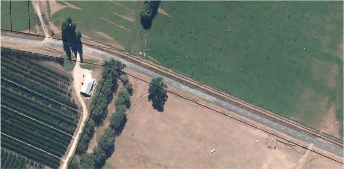
P.   2 / 17

2.      Site Overview

2.1.    Location

2.1.1. The plan change site is located to the west of the State Highway 6 / Ripponvale Road
       intersection, just west of Cromwell. The site is currently zoned as Rural Resource Area in the
       Central Otago District Plan (‘District Plan’) and is currently used for rural activities.

2.1.2. The location of the site in the context of the local area is shown in Figure 1 and in more detail
       in Figure 2.

                                                                    State
                          N                                       Highway 6

                                                       Site

                                                        Racecourse
                                          State                                          Cromwell
                                        Highway 6

                                      Figure 1: General Location of Development Site

                                                                State
                                                              Highway 6
                                                                                              N
                                                                                               Lake
                                                                                              Dunstan

                                              Site

                                                                              Cromwell

                                   Ripponvale                           State
                                      Road                            Highway 6

                              Figure 2: Aerial Photograph of Development Site and Environs

New Zealand Cherry Corp (Leyser) LP Limited                                   Proposed Rural Residential Plan Change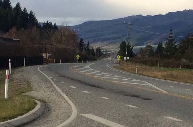
P.   3 / 17

2.2.    Roading Classification

2.2.1. The District Plan classifies State Highway 6 towards the east of the site as a Rural State
       Highway. Ripponvale Road is classified as a Rural Collector Road.

2.2.2. On this basis, it is reasonable to conclude that the primary role of the highway is to carry
       through traffic, with Ripponvale Road providing for local journeys and property access.

New Zealand Cherry Corp (Leyser) LP Limited                         Proposed Rural Residential Plan Change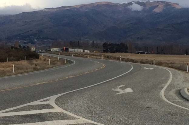
P.   4 / 17

3.      Current Transportation Networks

3.1.    Roading Network

3.1.1. In the vicinity of the site, Ripponvale Road is characterised by having two very straight sections
       of carriageway connected by a sharp, 90-degree curve which has a chevron board to direct
       drivers. One section of road has a broadly north-south orientation and serves a number of
       rural residential properties and agricultural uses. The other section of road has a broadly east-
       west orientation, and leads to State Highway 6.

3.1.2. Ripponvale Road is subject to a speed limit of 100km/h and has swales on both sides within
       wide grassed verges. On the east-west section of road, the carriageway seal width is 5.8m,
       with a centreline but no edgeline markings. The legal width is 20m.

                               Photograph 1: Ripponvale Road Looking West, Towards Site

3.1.3. At its eastern extremity, Ripponvale Road meets State Highway 6 at a priority (‘give-way’)
       controlled intersection. The intersection has an auxiliary left-turn lane which is around 75m
       long and 3.5m wide. It also has an auxiliary right-turn lane of 3.5m width, which is 20m long
       with an extended taper. Sight distances at the intersection are excellent, and in excess of 350m
       in each direction.

New Zealand Cherry Corp (Leyser) LP Limited                               Proposed Rural Residential Plan Change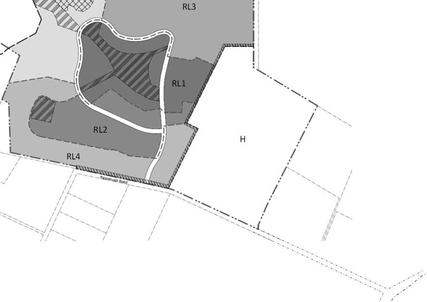
P.   5 / 17

                  Photograph 2: Aerial Photograph of State Highway 6 / Ripponvale Road Intersection

                         Photographs 3 and 4: Sight Distances to the Left and Right at State Highway 6 /
                                                 Ripponvale Road Intersection

3.1.4. Towards the south, the highway provide access to Frankton, Queenstown and further south to
       settlements at the bottom of the South Island. Towards the north, the highway provides access
       into Cromwell via a network of district roads, and also to State Highway 8B which provides a
       connection to State Highway 8 and locations throughout the South Island. State Highway 6
       also passes close to Wanaka before turning westwards towards the West Coast.

3.2.    Non-Car Infrastructure

3.2.1. There is no infrastructure provided for walking and cycling in the immediate area although the
       low traffic flows on the road means that cyclists can safely share the carriageway with
       motorised vehicles and there are wide grassed berms that can be used by pedestrians.

3.2.2. There is a walkway provided between the highway and Waenga Drive, and this meets the
       highway around 400m north of Ripponvale Road. At its eastern end, Waenga Drive forms the
       southern boundary to Cromwell town centre around

3.3.    Future Changes

3.3.1. There are no known changes to the roading environment in the immediate area that are set
       out in any overarching strategies or guides.

New Zealand Cherry Corp (Leyser) LP Limited                                 Proposed Rural Residential Plan Change
P. 6 / 17
4. Current Transportation Patterns
4.1. Traffic Flows
4.1.1. The New Zealand Transport Agency (“NZTA”) carries out regular traffic counts on the state
highway network. The closest count site on the state highway is site 00600947 which is
located to the south of the State Highway 6 / State Highway 8B intersection, and around 1.3km
northeast of Ripponvale Road. In 2017, the highway had an Annual Average Daily Traffic of
4,887 vehicles (two-way). By way of a check on this, the traffic counter in the Gibbston Valley
further south carried an almost-identical traffic flow (to within 1.5%), which is as would be
expected due to the lack of development and roading connections for vehicles to leave or join
the highway between the two locations. It can therefore be concluded that the recorded data
represents the traffic flows past the site.
4.1.2. The survey station counts data continuously, and the following graph shows a breakdown of
the daily flows for the past 12 months:
Figure 3: Traffic Flows on State Highway 6
4.1.3. As shown above, the weekday traffic flows display a morning and evening peak hour. The
average recorded traffic flows were:
Morning peak hour, 7am to 8am: 254 vehicles southbound, 77 vehicles northbound;
and
Evening peak hour, 5pm to 6pm: 171 vehicles southbound, 290 vehicles northbound
4.1.4. This indicates a tidal flow on the highway, towards the direction of Queenstown in the morning
and away from Queenstown in the evening. Other surveys in the area have indicated a similar
direction of travel.
4.1.5. The data also shows that the traffic flows during the weekend are relatively high, and approach
that of the weekday evening peak. This pattern of traffic flows is typical of a highway carrying
recreational traffic. Further evidence of recreational traffic is shown in the seasonality of the
highway. The average daily traffic volume during the summer months (December, January and
February) was 5,910 vehicles (two-way), compared to 4,190 vehicles (two-way) during June,
July and August, some 29% lower.
New Zealand Cherry Corp (Leyser) LP Limited Proposed Rural Residential Plan ChangeP. 7 / 17
4.1.6. Over the past five years, volumes on the highway have increased from 3,130 vehicles per day
to 4,887 vehicles per day (that is, a growth of 351 vehicles per day in each year). This equates
to an annual growth of 7.2%, expressed as a percentage of the 2017 volumes.
4.1.7. As part of this commission, a traffic survey was carried out at the State Highway 6 / Ripponvale
Road intersection during July 2018. The results are summarised below.
Figure 4: Existing Peak Hour Traffic Flows at the State Highway 6 / Ripponvale Road Intersection
4.1.8. The surveys support the NZTA data with a predominant southbound flow on the highway in
the morning (towards Queenstown), and the direction of flows being reversed in the evening.
4.1.9. The total volume observed on the highway is 479 vehicles in the morning peak hour and 444
vehicles in the evening peak hour. This compares to 331 and 461 vehicles respectively as
recorded by the NZTA traffic counter. Although there are some differences in the data, the
surveyed volumes are considered to be robust.
4.1.10. It can be seen that Ripponvale Road is lightly trafficked with peak hour volumes of less that 30
vehicles (two-way). This suggests daily volumes of no more than 300 vehicle movements.
The NZTA Crash Analysis System (“CAS”) includes details of traffic flows on district roads
obtained from council RAMM databases, and this confirms that traffic volumes are low with
CAS recording 200 vehicles per day.
4.1.11. The Austroads Guide to Traffic Management Part 3 (‘Traffic Studies and Analysis’) sets out
thresholds regarding the need for detailed traffic analyses at intersections, and the traffic flows
below which detailed analyses of unsignalised intersections are unnecessary since the
intersection operates under ‘free-flow’ conditions. An extract from this is replicated below.
Traffic Volumes (Vehicles Per Hour)
Major Road Type
Major Road Minor Road
400 250
Two lane road 500 200
600 100
Table 1: Extract from Table 6.1 of Austroads Guide to Traffic Management Part 3 (Intersection
Volumes below which Capacity Analysis is Unnecessary)
New Zealand Cherry Corp (Leyser) LP Limited Proposed Rural Residential Plan ChangeP. 8 / 17
4.1.12. It can be seen that the volumes at the State Highway 6 / Ripponvale Road intersection fall
below these thresholds, and accordingly, no analysis has been carried out at the intersection.
In essence, at present it will operate under ‘free-flow’ conditions, and this was confirmed during
the traffic surveys will negligible delays to turning traffic being observed.
4.2. Non-Car Modes of Travel
4.2.1. Given that the area is predominantly rural, it can reasonably be expected that it will be relatively
lightly used by pedestrians and cyclists. During site visits (a total of six hours) no pedestrians
or cyclists were observed. It is considered that the absence of infrastructure for these road
users is therefore not unreasonable.
4.2.2. There are no regular bus services that pass the site. Although several longer-distance services
pass nearby on the highway, there are no bus stops provided within walking distance.
4.3. Road Safety
4.3.1. The NZTA Crash Analysis System has been used to establish the location and nature of the
recorded traffic crashes in the vicinity of the plan change area. All reported crashes between
2008 and 2017 were identified, plus the partial record for 2018, for Ripponvale Road between
State Highway 6 and 100m south of the 90-degree bend (a ten-year period is used due to the
low traffic flows). All reported crashes between 2013 and 2017 were identified, plus the partial
record for 2018, for State Highway 6 for 200m on either side of the intersection with Ripponvale
Road (a five-year period is used due to the higher traffic flows).
4.3.2. This showed that there were three reported crashes in the area. None resulted in any injuries.
One crash occurred in Ripponvale Road around 1km west of the highway, when an
eastbound driver stopped suddenly in the carriageway for no apparent reason, and
was struck by a following eastbound vehicle;
One crash occurred on State Highway 6, 130m north of Ripponvale Road, when a
northbound driver left the road (no reason for this was given); and
One crash occurred on State Highway 6, 180m north of Ripponvale Road, when a
northbound driver turned left into the cherry orchard but in so doing, firstly pulled to the
right-hand-side of the highway. A following driver thought that the first driver was
turning right (not left) and overtook the first vehicle on the left. The vehicles then
collided.
4.3.3. No crashes have been reported at the State Highway 6 / Ripponvale Road intersection.
4.3.4. The historic pattern of crashes does not indicate any particular safety-related deficiencies on
either this section of highway or Ripponvale Road.
New Zealand Cherry Corp (Leyser) LP Limited Proposed Rural Residential Plan ChangeP. 9 / 17
5. Proposal
5.1. The proposed plan change will facilitate the development of up to 160 rural residential
dwellings.
5.2. Since the proposal is for a plan change, there are no confirmed scheme plans for the area.
However a Structure Plan has been produced. This shows that access onto the roading
network is proposed to be gained onto Ripponvale Road around 1.14km west of the state
highway, in a location which was previously an unformed legal road (for clarity, this legal road
has been closed and stopped) and the land is now privately owned.
5.3. The access road will serve a loop road located approximately centrally within the plan change
area.
N N
State
Highway 6
Ripponvale
Road
Figure 5: Annotated Proposed Structure Plan (Extract from Rough and Milne Drawing ‘Structure
Plan’ Numbered L1.1 Rev 0)
New Zealand Cherry Corp (Leyser) LP Limited Proposed Rural Residential Plan ChangeP. 10 / 17
6. Traffic Generation and Distribution
6.1. Traffic Generation
6.1.1. Traffic generated by residential developments is known to vary for a variety of reasons, with
one such reason being the proximity (or otherwise) to employment and community facilities.
Where a dwelling is some distance from these types of facilities, the traffic generation rates
tend to be lower than for residences that are closer due to ‘trip chaining’, that is, the tendency
of a resident to carry out multiple visits to different destinations during the same trip away from
the dwelling.
6.1.2. In this case, it is likely that some traffic will be associated with employment locations in
Queenstown but there is also likely to be travel to/from local destinations also. Accordingly,
for this analysis a rate of 6 vehicle movements per day per residence has been used, with 1
vehicle movement per residence occurring in each of the peak hours.
6.1.3. In the morning peak hour, 90% of these vehicles are likely to be exiting the site, with 65% of
the generated vehicle movements entering the plan change site in the evening peak hour.
6.2. Trip Distribution
6.2.1. With regard to the distribution of these vehicles, it is anticipated that all drivers travelling to/from
the site would pass through the State Highway 6 / Ripponvale Road intersection because this
provides the most direct route to education, employment and community facilities.
6.2.2. However once at the intersection, the direct is less certain because some drivers will travel
towards the facilities within Cromwell and others will travel towards destinations further afield
such as Queenstown, Wanaka and Alexandra. For this assessment, it is anticipated that:
25% of generated travel will travel towards Cromwell and local facilities; and
80% of the remaining traffic will travel towards the south and the direction of
Queenstown, with the remainder travelling north towards Wanaka and Alexandra.
6.2.3. This gives rise to the following traffic generation:
Figure 6: Traffic Generation Due to Development of Plan Change Site at the State Highway 6 /
Ripponvale Road Intersection
New Zealand Cherry Corp (Leyser) LP Limited Proposed Rural Residential Plan ChangeP. 11 / 17
7. Effects on the Transportation Networks
7.1. Intersection Capacity
7.1.1. The Figures above show that the overall traffic flows continue to fall below that where a formal
assessment of the State Highway 6 / Ripponvale Road intersection is required. Nevertheless,
for completeness, an assessment has been carried out and the results are summarised below.
Morning Peak Hour Evening Peak Hour
Road and Movement Avg Delay 95 %ile Level of Avg Delay 95 %ile Level of
(secs) Queue (veh) Service (secs) Queue (veh) Service
State Highway 6 L 8.5 0 A 8.6 0 A
State Highway 6 R 8.1 0 A 8.5 0 A
L 9.1 1 A 9.6 0 A
Ripponvale Road
R 11.2 1 B 11.8 0 B
Table 2: Performance of State Highway 6 / Ripponvale Road with Full Development of Plan Change
Site
7.1.2. It can be seen that queues and delays are negligible.
7.1.3. As set out above, the traffic flows on the highway are seasonal. Although the observed
volumes compare favourably with the summer volumes, the flows on the highway have been
increased by 30% to reflect the seasonality. At the same time, ten years of background traffic
growth on the highway has been applied, as is best practice when considering a plan change
request. This results in the through-traffic on the highway being factored by 2.23. The results
are summarised below:
Morning Peak Hour Evening Peak Hour
Road and Movement Avg Delay 95 %ile Level of Avg Delay 95 %ile Level of
(secs) Queue (veh) Service (secs) Queue (veh) Service
State Highway 6 L 8.5 0 A 8.6 0 A
State Highway 6 R 9.0 0 A 10.5 0 B
L 13.0 2 B 14.0 1 B
Ripponvale Road
R 23.0 2 C 24.3 1 C
Table 3: Performance of State Highway 6 / Ripponvale Road with Full Development of Plan Change
Site, Highway Traffic Factored
7.1.4. As would be expected, the delays on Ripponvale Road increase under this scenario but the
increase is minor. The queue increases by just one vehicle compared to the unfactored data
and delays increase by around 12 seconds. The resultant levels of service (typically B and C)
are not unreasonable for a rural intersection under peak traffic loadings.
7.1.5. No modelling has been undertaken for the access between the plan change site and
Ripponvale Road. Given that the volumes on both roads will be low, the thresholds set out in
the Austroads Guide will not be met and the intersection(s) will operate under free-flow
conditions.
7.1.6. Overall then, the traffic generated by full development of the plan change site can easily be
accommodated on the road network.
New Zealand Cherry Corp (Leyser) LP Limited Proposed Rural Residential Plan ChangeP. 12 / 17
7.2. Non-Car Modes of Travel
7.2.1. The subdivision is likely to result in increased levels of walking and cycling in the immediate
area. However these will only be moderate because of the lack of destinations within a viable
walking/cycling distance, meaning that most walking/cycling will occur for recreational use.
The traffic flows on Ripponvale Road will remain low, even with the plan change site fully
developed, and consequently it is not considered that any additional infrastructure is required
for pedestrians or cyclists.
7.2.2. The size of the subdivision is not sufficient that it will give rise to the need for a public transport
service.
7.3. Road Safety
7.3.1. Based on a review of the road safety records, the proposal is unlikely to result in adverse road
safety effects arising as a result of the increase in traffic flows on the road network.
7.3.2. The location of the access into the site (as shown on the Structure Plan) means that a sight
distance towards the east of 350m is achieved (limited by the road boundary) with 320m
achieved towards the west (limited by the curve of the formed road). For clarity, both of these
sight distances are measured at a distance of 5.5m back from the edge of the traffic lane of
Ripponvale Road, and both considerably exceed the requirements for sight distances for the
prevailing 100km/h speed limit.
N
Figure 7: Sight Distance Towards the East at the Proposed Site Access
N
Figure 8: Sight Distance Towards the West at the Proposed Site Access
New Zealand Cherry Corp (Leyser) LP Limited Proposed Rural Residential Plan ChangeP. 13 / 17
7.4. Ripponvale Road Upgrading
7.4.1. Development of the site will inevitably increase traffic flows on Ripponvale Road. As noted
above, the legal width is 20m and the carriageway is presently 5.8m wide. Given the extent of
traffic flows presently using the road (200-300 vehicle movements per day, as noted above),
the Council’s Engineering Code of Practice requires a 6.0m width with 0.25m metalled
shoulders. The existing road is therefore of a lesser standard than required under the Code
of Practice.
7.4.2. The proposal will result in traffic flows increasing by around 960 vehicles per day. Under the
Code of Practice this requires a 7.0m wide carriageway with 0.25m metalled shoulders.
7.4.3. In view of the 20m road reserve width and the favourable topography, it is considered that this
widening can easily be accomplished.
7.4.4. Finally, the proposal will create a priority intersection on Ripponvale Road. The traffic flows
on Ripponvale Road will not justify the provision of auxiliary turning lanes at these, and the
wide road reserve means that an appropriate design can be constructed.
New Zealand Cherry Corp (Leyser) LP Limited Proposed Rural Residential Plan ChangeP. 14 / 17
8. Statutory Framework
8.1. Introduction
8.1.1. There are a number of statutory documents that are relevant to plan change requests. These
are discussed in detail below, together with an assessment of whether the plan change request
aligns with the strategic guidance given.
8.2. Otago Regional Land Transport Plans 2015-2021
8.2.1. The purpose of the RLTP is to “set our vision of transport in the future and how intend to
achieve this by funding and providing transport services and infrastructure”. The June 2018
update of the document also adds “…and by concentrating over the next few years on
achieving a safer and more sustainable transport system that supports and enhances regional
development”.
8.2.2. The key long-term strategic objectives are:
A transport system that is safe;
A transport system that delivers appropriate levels of service;
A transport system that supports economic activity and productivity;
A transport system that provides appropriate transport choices;
A transport system based on effective coordination; and.
Mitigating the effects of the transport system on the environment
8.2.3. The traffic generated by development of the plan change area can be accommodated on the
roading network with appropriate levels of service, an there are no reasons to anticipate that
adverse road safety effects would arise. The location of the plan change area is around 2.8km
from Cromwell town centre meaning that it is within a practical cycling distance. This route
would be on lightly trafficked roads (Ripponvale Road, an off-road walkway and Waenga Drive,
other than a 0.4km section which would be alongside the highway.
8.2.4. If there was to be a local bus network within Cromwell in future, or if longer-distance services
were to stop nearby, then one location would be in the vicinity of the State Highway 6 /
Ripponvale Road intersection. This would therefore result in the site being accessible by public
transport.
8.3. Otago Regional Public Transport Plan 2014
8.3.1. This Plan focusses on areas with higher numbers of residents, specifically the Wakatipu Basin
and Dunedin. As such, there is little mention made of Cromwell or surrounding areas. However
the plan change request does not preclude the ability to implement public transport in future.
8.4. Central Otago District Plan
8.4.1. The District Plan sets out a number of transportation-related rules with which any development
is expected to comply. Although the proposal is for a plan change, consideration of these rules
is important at this stage in order to identify whether the plan change provisions should seek
to exempt development from any rules, or conversely, to introduce new rules specific to the
zone.
New Zealand Cherry Corp (Leyser) LP Limited Proposed Rural Residential Plan ChangeP. 15 / 17
8.4.2. Consequently an assessment of the plan change provisions against these rules has been
undertaken and the results are summarised below
8.4.3. District Plan Part 12.7.1: Access Standards from Roads: Part (ii): Sight Distances
8.4.3.1. Under the District Plan, assuming that roads within the plan change are subject to a speed
limit of 100km/h then each lot requires a sight distance of 160m at its access. This can be
achieved through careful site layout design.
8.4.3.2. However it is possible that there will be a number of lots which do not achieve the appropriate
sight distance because the lot is adjacent to an intersection and the intersection geometry
means that the sightline passes across land outside the lots and the road reserve, or because
the access is on the inside of a curve and the curve restricts the sight distance.
8.4.3.3. The sight distance of 160m is based upon a vehicle speed of 100km/h. However as a vehicle
approaches an intersection it must slow down in order to be able to give-way to other vehicles
and/or to negotiate the intersection geometry. Since there is a direct relationship between
vehicle speeds and sight distances, it follows that where speeds are physically reduced, sight
distances can also be reduced while still allowing a driver to see and react to a potential hazard
ahead.
8.4.3.4. Where a sightline passes across land which is within the same or an adjacent lot, it is possible
to place a consent notice on the lot title such that no obstruction of more than 1m in height is
permitted to be placed within the sightline.
8.4.3.5. Taking these matters into account, it is considered that the sightlines at each lot access will be
appropriate for the prevailing speeds or can be suitably addressed through consent notices.
8.4.4. District Plan Part 12.7.1: Access Standards from Roads: Part (vii): Access to Rural Collector
Roads
8.4.4.1. This part of the District Plan requires accesses to be constructed to particular layouts. In the
event that there are any direct accesses onto Ripponvale Road, these layouts can be
achieved.
8.4.5. District Plan Part 12.7.2: Parking: Part (i): Number of Spaces
8.4.5.1. At this stage, no detailed layout has been produced for the individual lots. However their likely
size means that each will be able to provide several car parking spaces, meeting Plan
requirements.
8.4.6. District Plan Part 12.7.2: Parking: Part (ii): Parking in Excess of Three Spaces
8.4.6.1. It is not expected that any lots will provide more than three parking spaces.
8.4.7. District Plan Part 12.7.3: Loading and Manoeuvring: Part (i): Servicing Activities
8.4.7.1. The proposal is for residential activities and therefore the loading and unloading of goods is
not expected to occur frequently.
New Zealand Cherry Corp (Leyser) LP Limited Proposed Rural Residential Plan ChangeP. 16 / 17
8.5. Council’s Engineering Code of Practice
8.5.1. The Council has a Code of Practice which sets out appropriate widths for the internal roads
within the plan change site. It is not considered that there are any reasons why these could
not be met.
8.6. Summary
8.6.1. It is considered that the plan change request is aligned with the strategic objectives of the
Otago Regional Land Transport Plans 2015-2021, as relevant to this particular area. The
Otago Regional Public Transport Plan is not particularly relevant due to the focus on other
areas, but the plan change request is not contrary to it.
8.6.2. The site layout is likely to be able to comply with all the transportation requirements of the
District Plan, other than potentially in respect of Part 12.7.1(ii) Sight Distances. However any
non-compliances with the sight distances are likely to arise due to the proximity of the lot
access to curves or intersections, with those geometric features also meaning that vehicle
speeds will be reduced in the immediate area, which in turn means that shorter sight distances
will be adequate.
8.6.3. In view of the situation, it is not considered that the plan change proposal needs to include any
specific transportation-related Rules. Rather, the existing Rules of the District Plan are
appropriate, and resource consent applications can be made in the event that the detailed site
layout design introduces non-compliance with these.
New Zealand Cherry Corp (Leyser) LP Limited Proposed Rural Residential Plan ChangeP. 17 / 17
9. Conclusions
9.1. This report has identified, evaluated and assessed the various transport and access elements
of a plan change request for rural residential activities (facilitating up to 160 lots) at Cromwell.
9.2. Overall it is considered that the traffic generated by the development of the plan change site
can be accommodated on the adjacent roading network without capacity or efficiency issues
arising. In practice, the traffic generated by the development results in minimal queues and
delays, even when allowing for season traffic flows on the highway and for ten years of
prevailing ambient traffic growth.
9.3. The crash history in the vicinity of the plan change site does not indicate that there would be
any adverse safety effects from the proposal.
9.4. The internal roads within the site are likely to be able to comply with the Council’s standards,
but minor upgrading of Ripponvale Road will be required. In view of the 20m legal width, this
can easily be accomplished.
9.5. Although there is presently only a Structure Plan proposed, it is likely that there will be a high
degree of compliance with the transportation requirements of the District Plan. The most likely
source of any non-compliance will be due to restricted sightlines where lots gain access close
to curves or intersections but these features also mean that vehicle speeds will be reduced in
the immediate area, which in turn means that shorter sight distances will be adequate.
9.6. The plan change is also aligned with overarching Otago Regional Land Transport Plans, as
relevant to the area.
9.7. Overall, and subject to the preceding comments, the plan change request can be supported
from a traffic and transportation perspective and it is considered that there are no traffic and
transportation reasons why the plan change could not be approved.
Carriageway Consulting Limited
May 2019
New Zealand Cherry Corp (Leyser) LP Limited Proposed Rural Residential Plan Changetraffic engineering | transport planning A. PO Box 29623, Christchurch, 8540 P. 03 377 7010 E. office@carriageway.co.nz
You can also read