Application for attestation of exemption (Demande d'attestation de non-assujettissement) Top Portion of Triple Lynx - COMEV
←
→
Page content transcription
If your browser does not render page correctly, please read the page content below
Bulk Sampling – Windfall Lake Project

Application for attestation of exemption
(Demande d’attestation de non-assujettissement)
Top Portion of Triple Lynx

Presented to:

Administrateur provincial de la Convention de la Baie-James et du Nord québécois
Sous-ministre du Développement durable, de l’Environnement
et de la Lutte contre les changements climatiques
Édifice Marie-Guyart, 30e étage
675, boul. René-Lévesque Est, boîte 02
Québec (Québec) G1R 5V7

Prepared by:    Andrée Drolet, ing., PMP
                Environmental Director
Presented by: Alexandra Drapack, P.Eng. (Ontario), MBA
              Vice President Environment Services & Sustainable Development
Report issued on November 20, 2019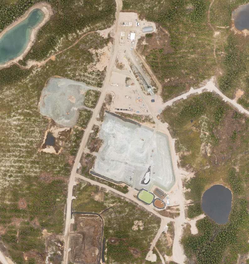
Table of contents
1.0 PROJECT PROPONENT ................................................................................................................................... 4

2.0 NAME OF THE PROJECT ................................................................................................................................. 4

3.0 LOCATION OF PROJECT AND MINING PROPERTY ................................................................................................ 4
   Location..................................................................................................................................................... 4
   Mining Property ........................................................................................................................................ 5

4.0 PROJECT DESCRIPTION – OBJECTIVES AND JUSTIFICATION ................................................................................... 5
   Permitting Background ............................................................................................................................. 5

5.0 EXPLORATION BACKGROUND ......................................................................................................................... 7

6.0 BULK SAMPLING REQUEST............................................................................................................................. 9
   Context ...................................................................................................................................................... 9
   Objectives and Justification ...................................................................................................................... 9
   Drilling for the Exploration Ramp ........................................................................................................... 10
   Relative Size of the Bulk Sample ............................................................................................................. 10

7.0 LEARNING FROM BULK SAMPLE AND UNDERGROUND ACCESS ........................................................................... 10
   Geology and Structure ............................................................................................................................ 10
   Mining ..................................................................................................................................................... 11
   Metallurgy ............................................................................................................................................... 12
   Mineral Processing.................................................................................................................................. 12
   Water and Waste Rock Management ..................................................................................................... 12

8.0 PROJECT INFRASTRUCTURE .......................................................................................................................... 13
   Existing Infrastructure and Evolution ..................................................................................................... 13
   Additional Infrastructure and Upgrade................................................................................................... 16
   Working at Windfall Lake Camp.............................................................................................................. 17

9.0 COMPONENTS OF THE ENVIRONMENT ........................................................................................................... 18
   Biophysical Environment ........................................................................................................................ 18
   Human Environment ............................................................................................................................... 21

10.0 MAIN POTENTIAL IMPACTS........................................................................................................................ 23
   Fish Habitats............................................................................................................................................ 23

Page 2|                                               Application for Attestation of Exemption
                                                                                     20/11/2019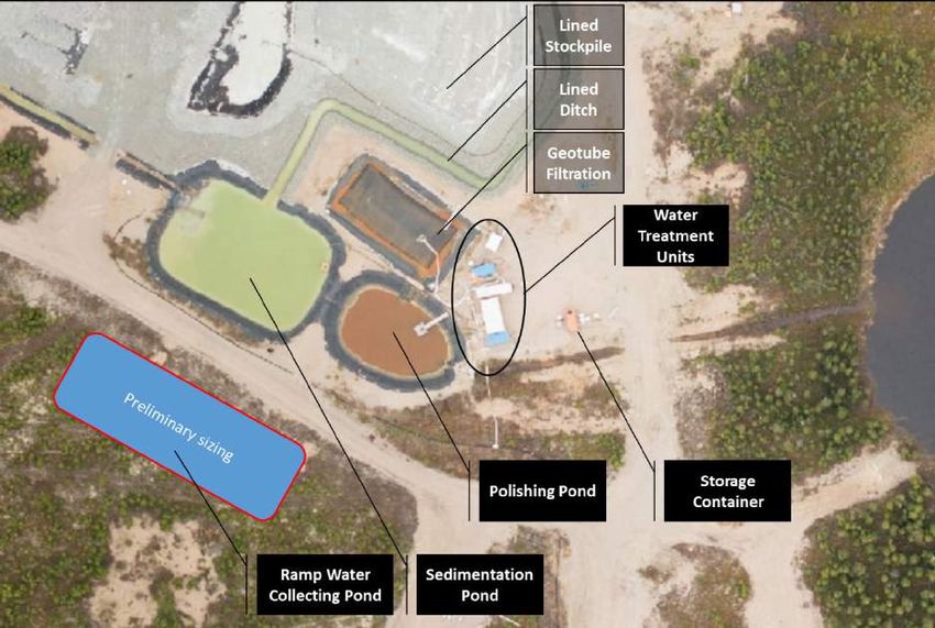
Wetlands ................................................................................................................................................. 23
   Woodland Caribou .................................................................................................................................. 23
   Small Wild Game ..................................................................................................................................... 23
   Land Clearing........................................................................................................................................... 23
   Traffic ...................................................................................................................................................... 24
   Dust Management .................................................................................................................................. 25
   Waste Management at Windfall Lake .................................................................................................... 25
   Water Management................................................................................................................................ 26

11.0 INFORMATION AND PUBLIC CONSULTATION PROCESS .................................................................................... 29
   Cree Community of Waswanipi .............................................................................................................. 29
   Communities of Lebel-sur-Quévillon and Senneterre ............................................................................ 32

12.0 PROJECT IMPLEMENTATION SCHEDULE ........................................................................................................ 33

13.0 NEXT STEPS AND RELATED PROJECTS ........................................................................................................... 33

14.0 SIGNATURE OF APPLICANT......................................................................................................................... 34

Page 3|                                                Application for Attestation of Exemption
                                                                                      20/11/2019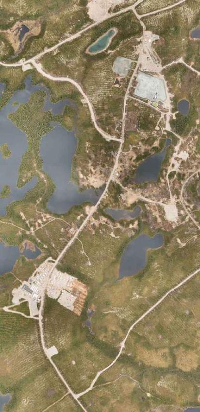
1.0 PROJECT PROPONENT
Name of applicant:                      Osisko Mining Inc.
Address:                                155, University Avenue, Suite 1440
                                        Toronto (Ontario) M5H 3B7
Telephone:                              416 848-9504
Fax:                                    416 363-9813
Website:                                www.osiskomining.com

Authorized representative:              Ms. Alexandra Drapack, P.Eng.(Ontario), MBA
                                        Vice President
                                        Environment Services & Sustainable Development
Email:                                  adrapack@osiskomining.com
Québec business number
The number for Osisko Mining Inc. recorded in the Centre informatique du registre des entreprises du
Québec, assigned by the Registraire des enterprises is 1172033616.
Authorized signatory
A resolution of the board of directors authorizes Ms. Alexandra Drapack, Vice President Environment
Services & Sustainable Development, to act on behalf of the organization. The resolution is presented in
Appendix A.

2.0 NAME OF THE PROJECT
Bulk Sampling – Windfall Lake Project

3.0 LOCATION OF PROJECT AND MINING PROPERTY
Location
The Windfall Lake Property is in the Nord-du-Québec administrative region, less than 10 kilometres north
of the border with the Abitibi-Témiscamingue region. The property lies on land of the municipality of
Eeyou Istchee James Bay Regional Government, more specifically in the Urban Township. The Windfall
Lake exploration camp and ramp portal area is 115 kilometres from Lebel-sur-Quévillon and accessible by
forestry roads (road 1000 to kilometre 12, road 5000 to kilometre 66, and road 6000 to kilometre 112 –
Windfall Lake). It is also possible to reach the site from Chapais by a series of forestry roads (151
kilometres). The geographic coordinates of the Windfall Lake site are as follows (property centre):
    •    Latitude north (NAD 83): 49° 04' 14"
    •    Longitude west (NAD 83): 75° 39' 00"
The Windfall Lake Property lies in a remote area dominated by mining and forestry activities. Map 1 shows
the general location of the exploration site.

Page 4|                             Application for Attestation of Exemption
                                                                   20/11/2019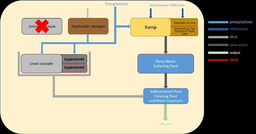
Mining Property
The Windfall Lake property currently consists of 285 claims covering approximately 12,467 hectares and
the claim holder is Eagle Hill Exploration Corporation (Eagle Hill), a wholly owned subsidiary of Osisko
Mining Inc. (Osisko Mining). Operations related to bulk sampling will be carried out on the following
claims:
Ramp portal area
    •   2379373
    •   2379374
    •   2376883
    •   2376889
    •   2376861
    •   2376862
    •   2376866
Claims are shown on Map 2.

4.0 PROJECT DESCRIPTION – OBJECTIVES AND JUSTIFICATION
Permitting Background

In 2007, Noront Resources Ltd (Noront) obtained the necessary authorizations to proceed with the bulk
sampling of 44,500 tonnes of ore at the Windfall Lake site. According to the various applications prepared
at the time by Genivar on behalf of Noront, the bulk sampling work was to involve driving a ramp that
would generate 157,800 tonnes of waste rock and 23,500 m3 tonnes of overburden. Noront obtained the
following authorizations:

    •   Attestation of exemption from the environmental and social impact assessment and review
        procedure stipulated in Chapter II of the Environment Quality Act (EQA) for a bulk sampling
        program at the Windfall Lake site, issued to Noront on December 3, 2007.
    •   Certificate of authorization from the MDDELCC pursuant to section 22 of the EQA to extract a bulk
        sample of 44,500 tonnes of ore at the Windfall Lake site (7610-10-01-70090-20 / 200178172),
        issued on September 18, 2007.
    •   Authorization from the MERN pursuant to section 69 of the Mining Act to extract a bulk sample
        of 25,000 tonnes of ore at the Windfall Lake site, issued on October 10, 2007.

Noront started ramp advancement in February 2008, but prematurely suspended all activities in October
of that same year before completing the planned work.

In 2017, Osisko Mining undertook steps to continue the bulk sampling work started by Noront. The
following authorizations have been obtained:

Page 5|                             Application for Attestation of Exemption
                                                                   20/11/2019
•   Attestation of exemption from the environmental and social milieu impact assessment and review
       procedure stipulated under Chapter II of the Environment Quality Act (EQA), for the completion
       of the bulk sampling program started and suspended by Noront in 2008, issued October 10, 2017.
   •   Transfer of the certificate of authorization (7610-10-01-70090-20 / 200178172) issued under
       section 22 of the EQA for Noront to collect a bulk sample at the Windfall Lake site to Osisko
       Mining, authorized by the MDDELCC on March 17, 2017.
   •   Certificate of authorization (7610-10-01-70090-22 / 401598242) issued under section 22 of the
       EQA to treat water generated by initial dewatering of the ramp and on-going dewatering during
       ramp extension and bulk sample extraction, obtained on May 25, 2017.
   •   MERN autorisation under section 69 of the Mining Act to extract a bulk sample of 5,000 tonnes of
       ore at the Windfall Lake site from the Caribou and 27 zones, issued on October 16, 2017.

The collection of a 5,500 tonnes bulk sample in Zone 27 of the Windfall Lake deposit was completed in
the fall of 2018. Transportation of the first portion of the sample was done between October 31st and
December 5th, 2018 followed by processing that took place between December 3rd and 8th, 2018. The
second portion was transported between January 29th and March 13th, 2019 and was processed between
May 12 to 16, 2019. Processing was done at the Northern Sun Mining Redstone Mill in South Porcupine,
Ontario.

At the end of 2017, Osisko Mining wanted to pursue exploration through the advancement of the
exploration ramp towards the Lynx and Underdog zones in order to take a 5,000 tonnes bulk sample in
each zone. At the time, the Lynx zone had just been discovered and presented great potential. Osisko
Mining therefore presented all necessary requests and obtain the following authorizations:

   •   Attestation of exemption from the environmental and social milieu impact assessment and review
       procedure stipulated under Chapter II of the Environment Quality Act (EQA) issued June 20, 2018,
       to undertake a bulk sampling program in the Underdog and Lynx zones.
   •   Certificate of authorization (7610-10-01-70090-27 / 401726560) issued under section 22 of the
       EQA to take bulk samples of the Lynx and Underdog zones and expand the waste rock stockpile,
       obtained on August 6, 2018.
   •   MERN authorization issued on December 18th, 2018 under section 69 of the Mining Act to extract
       two bulk samples of 5,000 tonnes of ore each at the Windfall Lake site Lynx and Underdog zones.

The collection of a 5,000 tonnes bulk sample in the Lynx zone was completed in September 2019.
Transportation of the sample was completed on October 31, 2019 and will be followed by processing at
the Northern Sun Mining Redstone Mill in South Porcupine, Ontario.

Throughout the above, the closure plan of the Windfall Lake Project was updated to reflect the changes
to the infrastructure. The following table shows the dates of the closure plan, the updates, addenda and
associated financial assurance.

Page 6|                            Application for Attestation of Exemption
                                                                  20/11/2019
Table 1: Closure Plan, Updates, Addenda and Associated Financial Assurance
FINANCIAL COMMENTS
OWNER DATE SUBMITTED DATE ACCEPTED
ASSURANCE
Noront August 2007 September 2008 $385,046 Initial closure plan
Eagle Hill November 2012 June 2014 $570,000 5-year update
Osisko July 2017 June 2018 $2,814,505 5-year update
Osisko December 2018 November 2019 $3,512,850 Addenda expansion lined stockpile.
The main components of the closure plan include:
• Blocking the portal with rockfill and preventing access to ventilation shafts using reinforced
concrete slabs;
• Dismantling all buildings and infrastructure, breaking apart and backfilling all concrete slabs, and
scarifying and revegetating footprints;
• Covering the material on the lined stockpile with a membrane to limit water contact and oxidation
within the stockpile;
• Reclamation of the unlined pad;
• Removing membranes and levelling the ditches, sedimentation and polishing ponds. Excavating
sludge accumulated in the Geotube™ as well as sludge in the ponds and disposing underground;
• Characterizing soils as required by regulations, and land rehabilitation if the characterization study
reveals the presence of contaminants above the regulatory criteria.
5.0 EXPLORATION BACKGROUND
Osisko Mining commenced exploration drilling on the Windfall Lake Project in 2015 with an initial 50,000
m drilling program. The program was subsequently increased several times over the years to its current
1,000,000 m program. The goals of the drilling program are to consolidate existing mineral resources, to
expand known mineralized zones and to discover additional zones.
In the initial drill program, all drilling was performed from the surface. Following dewatering and
rehabilitation of the existing ramp, underground drill rigs were added in 2018 to allow better definition of
the areas targeted for the bulk samples in Zone 27 and in the Lynx Zone. Currently, there are currently 22
drill rigs drilling from surface and two underground drills active on the project.
In 2018, Osisko Mining released the Osborne-Bell Resource Estimate for the Osborne-Bell gold deposit,
located 15 kilometres northwest of Lebel-sur-Quévillon, Québec. This estimate is the result of 927 drill
holes (279,925 metres) completed since 1994 by previous operators, including 50 completed after a
resource estimate published in 2012, and four new drill holes completed by Osisko Mining in
December 2017.
Osisko Mining also filed the Windfall Lake Mineral Estimate, the result of 1,453 drill holes
(596,733 metres) completed by previous operators since 1997 and 812 new drill holes (413,692 metres)
completed by Osisko Mining from October 2015 to March 2018.
Page 7| Application for Attestation of Exemption
20/11/2019At the end of 2018, Osisko Mining released the Updated Lynx Zone Resource Estimate. This updated
mineral resource estimate includes 138 infill drill holes (107,366 metres) completed in the Lynx Zone
between March 6, 2018 and October 27, 2018.
Table 2 shows the results of the Windfall Lake Mineral Resource Estimate (effective date of May 14, 2018)
including the Updated Lynx Zone Resource Estimate (effective date of November 27, 2018) and the
Osborne-Bell Resource Estimate (effective date of March 2, 2018).
Table 2: Windfall Lake and Osborne-Bell Resource Estimate*
Indicated Inferred
Tons Au(g/t) Au(oz) Tons Au(g/t) Au(oz)
Lynx 1,746,000 8.13 456,000 2,005,000 9.70 625,000
Zone 27 628,000 8.69 175,000 852,000 7.28 199,000
Caribou 318,000 7.12 73,000 2,767,000 5.80 516,000
Underdog 147, 000 9.00 43,000 4,380,000 6.77 953,000
Other 34,000 6.58 7,000 348,000 6.37 71,000
Osborne-Bell 2,587,000 6.13 510,000
Total 2,874,000 8.17 754,000 12,939,000 6.91 2,876,000
*See Windfall Lake and Osborne-Bell Resource Estimate notes and Updated Lynx Zone Resource Estimate notes in Appendix B.
Based on these resource estimates, Osisko Mining filed a Preliminary Economic Assessment (PEA) of the
Windfall Lake Project on June 12, 2018. The positive results of the PEA encouraged Osisko Mining to
initiate the work required on the Windfall Lake Project to move towards the next phase of study, namely
converting more of the Inferred resources into the Indicated category for inclusion in a Feasibility Study.
This requires a significant amount of additional drilling, hence the increase to a 1,000,000 m program.
Since the database closed in March 2018 to complete the PEA, a total of 395,000 m of additional drilling
has been completed, totalling more than 900,000 m on the project to date. Not only did the additional
drilling allow for a better understanding of the deposit, it also generated several new discoveries.
Osisko Mining made several new discoveries during 2019: Windfall North, Fox SW, Lynx Extension, and
Triple Lynx. Of these, the discovery of Triple Lynx in July 2019 was the most significant. Since Triple Lynx
is significantly closer to surface than the mineralization in the Underdog Zone, Osisko Mining decided to
postpone the advancement of the exploration ramp towards Underdog to focus on this new discovery
with more than 30,000 m in drilling into that zone.
Results to date from surface drilling into Triple Lynx discovery highlighted the importance of this portion
of the deposit.Triple Lynx is close in proximity to the Main Lynx zone, thus increasing the centre of gravity
of the deposit; it is closer to surface than Underdog and has promising gold grades. For these reasons,
understanding Triple Lynx is crucial to the Feasibility for the Windfall Lake Project.
Page 8| Application for Attestation of Exemption
20/11/20196.0 BULK SAMPLING REQUEST
Context
When Osisko Mining acquired the Windfall Lake Project in 2015, the mineral resource only included the
mineralization of Zone Caribou/27. Based on surface drilling completed during 2015-2017, Osisko Mining
realized that mineralization was present in 3 different zones: Caribou/27, Lynx and Underdog.
Subsequently, Osisko Mining wanted to pursue exploration through the advancement of the exploration
ramp towards the Lynx and Underdog zones in order to take a 5,000 tonnes bulk sample in each zone. At
that time, the distribution of tonnages was believed to be approximately 1/3, 1/3, 1/3 between the zones.
Additional drilling in 2018 and 2019 have highlighted the importance of Lynx as the centre of gravity of
the deposit. The following table shows the changes in tonnage distribution between April 2018 and
October 2019.
Table 3: Tonnage Distribution by Zones
% TOTAL TONNAGE % TOTAL TONNAGE
ZONES
APRIL 2018 OCTOBER 2019
Caribou/27 33.3% 15%
Lynx 33.3% 50%
Underdog 33.3% 35%
Our original estimate of the distribution did not account for the Triple Lynx Discovery, Lynx Extension and
continuous exploration success in the Lynx area. These new discoveries combined with the fact that
results from the Lynx area display higher gold grades than other sectors of the deposit lead us to estimate
a significant increase in contribution from the Lynx sector of the desposit when compared with the rest
of the deposit.
Moreover, the new Triple Lynx zone is located closer to surface, within vertical depths between 400 m
and 800 m. This makes it more attractive in the Feasibility Study because it will be faster and cheaper to
access than deeper sectors of the deposit. Mineralization closer to surface requires less development to
access them and therefore improves the feasibility of the project.
Therefore, to better reflect the significant increase of Lynx’s contribution to the deposit, Osisko Mining
wishes to postpone the collection of the Underdog bulk sample by a sample to be taken in the top portion
of Triple Lynx.
Objectives and Justification
The goal of exploration at the Windfall Lake Project is to define Indicated resources for inclusion in a
Feasibility Study. The justification presented in the previous request for bulk samples from the Lynx and
Underdog zones is still valid and pertinent for Triple Lynx; namely to gain an understanding of Windfall
Lake’s geological uniqueness, the complexity of the mineralization and the nugget effect.
Triple Lynx mineralization is hosted within an ultramafic rock whereas the bulk sample collected from Lynx
in 2019 was hosted within a felsic volcanic rock. This difference is significant and has implications on mine
design and mineral processing of the ore during the Feasibility Study, as follows:
Page 9| Application for Attestation of Exemption
20/11/2019• In terms of rock mechanics, behaviour of ultramafic rock and felsic volcanic rock is different
(ductile vs brittle), information from the bulk will be valuable. In addition, fault geometry and
orientation will be validated within the openings of the exploration ramp.
• Geometry of mineralization is influenced by the host rock (felsic vs ultramafic). It is therefore
difficult to proceed with geological modeling and extrapolate from data obtained from the Lynx
bulk (felsic rock) to ultramafic.
• Host rock type also influences gold recovery. Parameters such as rock hardness can have a
significant impact on crushing and consequently on mill design during the Feasibility Study. A
softer rock, such as an ultramafic rock, can be easier to crush but could result in challenges while
generating more fines.
Drilling for the Exploration Ramp
As the project advances and the deposit continues at depth, several challenges emerge from relying solely
on surface drilling. The exploration ramp represents a significant advantage by allowing drilling from
underground. As the exploration ramp is advanced to collect a bulk sample from the Triple Lynx sector,
installation of drill bays from the ramp will allow exploration drilling from underground into Lynx and
Triple Lynx. Underground exploration drilling from the ramp reduces the length of drill holes and reduces
drill hole deviation. Presently, an important part of the exploration program is focused on “infill drilling”
– drilling between existing drill holes. Specifically, closer drill hole spacing is required to convert Inferred
reserves to Indicated reserves for the Feasibility Study. Underground access would favourably decrease
the spacing between drill holes. Finally, it allows drilling of the deposit at depth which is challenging from
surface since Lynx cannot be drilled from the south due to the presence of a lake and wet land.
Underground drilling would therefore limit potential impacts at surface.
Relative Size of the Bulk Sample
Overall, if the current request is authorized, the total amount of ore that will be extracted from Windfall
Lake for bulk sampling could total 20,000 tonnes. From the PEA, the total tonnage of the proposed
Windfall Lake Project is 8.9 Mt over 8.1 years and the bulk sample only represents 0.2% of the total
tonnage or less than a week of mining.
7.0 LEARNING FROM BULK SAMPLE AND UNDERGROUND ACCESS
A bulk sample allows the acquisition of information on geology, structure, metallurgy, geotechnical,
mining, water management, waste rock management, and mineral processing. Here’s a summary of
what we have learned from bulk sampling in both Zone 27 and Lynx.
Geology and Structure
The mineralization of the Windfall Lake deposit is composed of several lenses. These lenses are complex and
difficult to interpret solely using data from surface drilling. The advancement of the exploration ramp across
and parallel to the mineralization allows an understanding of the interconnectivity between the different
lenses in the Caribou/27 Zone and the Lynx Zone. This provides the geological team a higher confidence in
their interpretation of the spacial continuity of the lenses.
P a g e 10 | Application for Attestation of Exemption
20/11/2019In Zone 27, Osisko Mining knew that the Red Dog generation dike was crosscutting the zone. Collection of
the bulk sample allowed us to realize that the dike displaces and rotates the mineralization locally. This
revelation will guide our geological interpretation and subsequent approach to mine design for the
Feasibility Study.
In Zone 27, we were able to better understand how faulting impacts the deposit. We were able to measure
the displacement of the fault and to assess the impact of faulting on mineralization.
In the Lynx zone, felsic volcanic rock (rhyolite) hosts the mineralization. Collecting the bulk sample from the
Lynx zone allowed us to discriminate between the different structures affecting these types of rocks and to
understand their behaviour. Measurement of fault displacement in the gallery of mineralization was
completed which is impossible to interpret from surface drilling data.
In both Zone 27/Caribou and the Lynx Zone, the mineralization was mapped and compared with
interpretation from surface drilling. This provides a better overall understanding of parameters controlling
the mineralization in the different zones.
The stopes were mapped and compared to the geological and block models to identify and improve
discrepancies in interpretation and modelling.
Through knowledge gained during collection of the Zone 27 bulk sample, the underground geology team
revised and improved their technique and approach to the second bulk sample collection in the Lynx Zone.
Mining
The advancement of the exploration ramp and installation of drifts undertaken to enable the collection
of the two bulk samples allowed us to assess and optimize the ground support, water management,
ventilation, rate of advancement, and manpower required. This information will provide crucial inputs
into the mine design portion of the Feasibility Study.
Specifically, from the bulk sample in Zone 27, it was possible to observe the ground conditions inside the
ore and verify the efficiency of ground support involving swellex and mesh straps in the walls. The drill
hole pattern for split blasting has been revised based on our observations. We have quantified the rates
of advancement for each zone of the deposit and can rely on this information instead of using generic
estimates.
The bulk sample in Lynx provided us with the opportunity to evaluate the mining method proposed in the
PEA: long hole stoping. This included verifying that the 20 m distance for sub levels (used in the PEA) is
feasible.
The stope length proposed in the PEA has been tested. We successfully utilized a 30” borehole in the
slot raise. The hanging wall and footwall stability is being continuously monitored, which will enable us
to verify the estimates from geotechnical testwork against real time observations. Finally, we had the
opportunity to test a very narrow section of the orebody (width of 2m and production holes of 2 ½ inch
diameter) and we will be able to use the results to guide our mine design for the Feasibility Study.
P a g e 11 | Application for Attestation of Exemption
20/11/2019Metallurgy
The grade estimate from the block model was reconciled against the measured grade provided from the
mill. The results allow us to better estimate the grade of the deposit by using more realistic capping values
and adapting the model for use in the Feasibility Study.
Mineral Processing
Power Requirements and Equipment Sizing
For the Zone 27 bulk sample, the energy requirement during crushing to reduce the ore from an 80%
passing feed size (F80) of 75mm to an 80% passing product size (P80) of 9.6mm was calculated to be 4.5
kWh/t. The energy requirement for the Lynx bulk sample will be calculated when it is processed at the
Redstone Mill. Energy requirements are specific to each ore type and the data is useful in designing the
equipment and estimating the power needs for the crushing circuit. In the absence of data from a real mill
trial, crushing circuit design is based on laboratory testwork and theoretical equations developed from
generic results which can mask critical and costly challenges. For example, recent challenges in industry
include the breaking of diamonds during crushing at the Renard mine and the lower than expected initial
throughput of the crushing circuit at the Malartic Gold Mine.
Gold Recovery: Gravity Circuit (Mill vs. Laboratory results)
During the processing of the Zone 27 bulk sample at the Redstone Mill, gold recovery from the gravity
circuit was 39% (December 2018) and 31% (May 2019). These values differ from the E-GRG laboratory test
results performed on ore from Zone 27 which showed gold recovery from gravity testing ranging from 22
to 27%. According to Gy’s theory, the bulk sample result in the mill is considered more accurate than the
laboratory results due to the larger sample size (5,000 tonnes vs 35 kg).
Flotation Circuit
Results from the flotation circuit during processing of the Zone 27 bulk sample at the Redstone Mill were
compared to laboratory results used in the PEA.The information will be useful in designing the processing
circuit for the Feasibility Study.
Tailings Management
Results from assays of the tailings stream from the Redstone Mill showed that the concentration of
sulphur was approximately 1%. This data is useful for comparison with geochemical laboratory testing and
for input into tailings design in the Feasibility Study.
Water and Waste Rock Management
In July 2017, Osisko Mining started to dewater the ramp and water treatment was put in place in
preparation for bulk sampling. In addition to groundwater, runoff water from the waste rock stockpile is
also treated. The treatment has been operating since (2.5 years) and valuable data on water quality is
being collected. This data will be very useful and will serve as input in the water quality model that will be
used in feasibility to design the water treatment system for the future mine.
In 2018, when preparing the second request for the Lynx and Underdog bulk samples, Osisko Mining asked
Golder to evaluate the volumes of groundwater infiltration in the exploration ramp. Volumes were
evaluated at 1,200 m3/day once the complete length of the ramp would be developed. Osisko Mining now
P a g e 12 | Application for Attestation of Exemption
20/11/2019has developed approximately 50% of the ramp (to Caribou-27, Lynx and Underdog) and the current
infiltration rate is measured to be between 500 to 600 m3/day depending on the season. The measured
infiltration rate confirms Golder’s evaluation and provides valuable information for the coming feasibility.
Osisko Mining faced certain challenges in controlling groundwater infiltration because of the important
number of exploration drill holes crossing the ramp. A grouting program of existing drill holes from surface
was undertaken in order to reduce water infiltration.
As in many other operations, ammoniacal nitrogen is one component in Windfall Lake’s water that needs
to be treated. With limited means, the environment team has learned to manage this component by
working with underground workers to limit the explosives residues left in the openings, managing volumes
and concentrations from feeds, controlling pH and adding treatment units.
Advancing the exploration ramp is producing waste rock that is stored on the lined stockpile. We now
better understand how fresh blasted rock influences water quality during periods of thaw. Also, by
surveying the volume of the pile and using data of tonnage of rock placed on the pile, we were able to
calculate our rock density and compare it with the density in our assumptions. This is a valuable number
that will be used by engineering teams during feasibility.
8.0 PROJECT INFRASTRUCTURE
Existing Infrastructure and Evolution
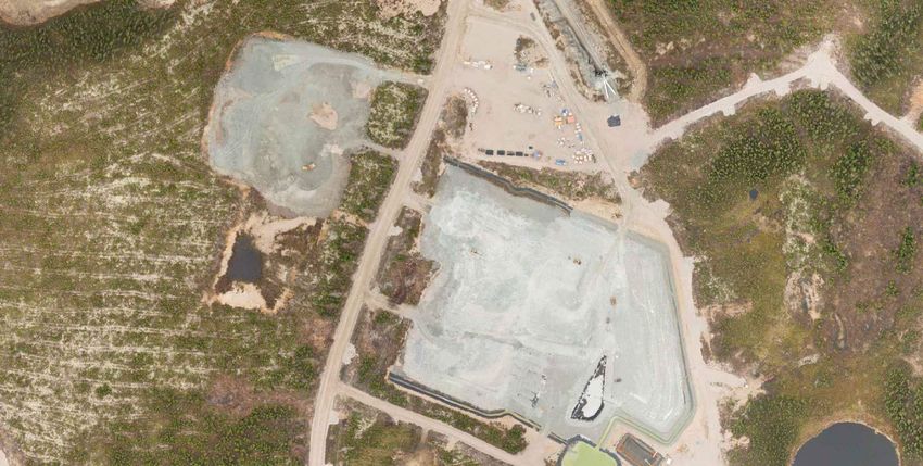
The Windfall Lake site is divided in two; the ramp area at the North and the camp area located at about
2 kilometres to the South (see Map 3).
Camp Area
To support exploration work, the following facilities have been built at the Windfall Lake Camp:
• Four core shacks
• Core storage area with racks
• Core cutting room
• Temporary trailer-type facilities for:
o Administrative offices
o Dormitories for 300 workers
o Recreation area
o Clinic and infirmary
o Kitchen and dining room
o Dry for underground workers
• Three wells (with certificate of authorization (CA)) for withdrawing potable water
• Three septic tanks and fields (CA) built for a capacity of 300 workers
• Industrial storage area with containers
• Two megadomes (environment and maintenance)
• Three temporary maintenance and storage areas for drilling companies (Forage Rouillier, Orbit-
Garant and Major) including gas tanks (3) and diesel tank (1)
• Propane tank for the kitchen (1)
• Diesel tank (1)
• Gas tank (1)
• Waste management area (composter, separate bins for domestic waste, wood, metal, etc..)
• Containers for contaminated soils
P a g e 13 | Application for Attestation of Exemption
20/11/2019• Containers for hazardous material management
• Helicopter landing pad.
Ramp Area
The portal and the ramp were started by Noront in 2007. In 2017, Osisko Mining dewatered, rehabilitated
and continued the advancement of the ramp. The ramp area includes the following surface infrastructure:
• Bypass access road and gate house
• Ramp portal
• Megadomes (2) for mining storage and maintenance
• Surface storage area
• Septic tank and field
• Detonator and explosive storage
• Ventilation raise and fans
• Propane tank for underground air heating (1)
• Diesel tanks (2)
• Overburden and compost stockpile
• Unlined waste rock stockpile
• Lined ore/waste rock stockpile (approx. 41,000 m2) with water collection ditch
• Sedimentation pond
• Polishing pond
• Water treatment units
• Geotube filtration system
• Pad with generators with capacity of 6MW
• Diesel tank (1)
Exploration Ramp
Noront started ramp advancement in February 2008, but activities were prematurely suspended in
October 2008 before completing the planned 3,300 metres of ramp. When work stopped, the ramp was
1,200 metres long and approximately 230 metres of drifts had been driven.
In July 2017, with all authorizations in hand, Osisko Mining dewatered the ramp and started the
rehabilitation of the existing ramp (ground support, installation of services, etc.) with the intention of
resuming advancement of the ramp and taking a bulk sample in the Caribou/27 zone. The ramp was
extended by 945 meters, a ventilation raise (107 meters) was put in place and a 5,500 tonnes sample was
taken in Zone 27 during the fall of 2018. The material from the sample was transported and processed at
the Northern Sun Mining Redstone Mill in South Porcupine.
Following the bullk sample collection in Zone 27 and after receipt of all necessary authorizations, the ramp
was extended by 2,135 meters to the Lynx zone for the purpose of taking a second bulk sample. Also, 533
meters of ramp; shorter than the initially 3,584 meters planned, were also driven towards Underdog
initially for the purpose of taking a bulk sample but also for exploration drilling. Indeed, the geological
information that was gathered through both drilling and driving the exploration ramp as well as the on-
P a g e 14 | Application for Attestation of Exemption
20/11/2019going results from our surface drilling campaign led to the conclusion that collecting a sample from
Underdog would not be as high a priority as exploring the top portion of the Triple Lynx sector.
In order to reach the top portion of Triple Lynx, 4,700 meters of ramp would have to be developed along
with two additional ventilation raises (220 and 260 meters) to support the underground activities. One of
the two ventilation raise will be underground and the other one will reach surface (location of surface
breakthrough is shown on Map 3).
Waste Rock Lined Stockpile
In 2008, as part of Noront’s bulk sample project, the lined stockpile consisted of two sections designed to
store ore and waste rock. Based on historical information, it appears that ore and waste rock were mixed
and stored on the facility. When Osisko Mining resumed the bulk sampling activities in July 2017, the
capacity of the existing stockpile was enough to store the waste rock from the advancement of the
exploration ramp to Zone 27. When Osisko Mining received the authorization to collect two additional
bulk samples, an extension to the lined stockpile was built. Contact water from the lined stockpile is
collected in a lined ditch and directed towards the sedimentation and polishing ponds for treatment.
The ramp towards Underdog is only developed to a length of 533 meters for now; shorter than the 3,584
originally planned. The exploration ramp going towards the top portion of Triple Lynx, will be 4,700 meters
in length therefore a second expansion of the lined stockpile is needed. The table below presents the
capacity of the lined stockpile over the different phases of the exploration project:
Table 4: Lined Stockpile Capacity
CAPACITY QUANTITY STORED
YEAR
(t) (t)
2007 107,500 0
2008 90,000 18,500
2017 90,000 29,166
2018 540,000 225,914
2019* 540,000 351,703
2020** 980,000 -
* As of October 31st, 2019
**Capacity to store the waste rock produced to advance the ramp to Triple Lynx.
The changes in configuration of the lined stockpile are described and shown in the following sections
entitled “Additional Infrastructure” and “Principal Potential Impacts”.
Unlined stockpile
When Osisko Mining acquired the Windfall Lake Project, the unlined waste rock stockpile contained
approximately 79,000 tonnes of material. The stockpile was seen by Osisko Mining as valuable material
and was reused as an underground road base for the exploration ramp and as a protection layer on the
synthetic membrane placed as the foundation of the lined stockpile expansion. The table below presents
the capacity of the unlined stockpile over the different phases of the exploration project:
P a g e 15 | Application for Attestation of Exemption
20/11/2019Table 5: Unlined Stockpile Capacity
REMAINING ON
REUSED
YEAR STOCKPILE
(t)
(t)
2008 0 79,000
2017 1,000 78,000
2018 25,500 52,500
2019* 2,000 50,500
* As of October 31st, 2019
Osisko Mining continues to use the material as a road base for the underground exploration ramp and it
is Osisko Mining’s intention to take this material again for use as liner protection layer during the
construction of the second extension of stockpile. Ideally, if remaining quantities match our construction
needs, the unlined stockpile will be empty, and its impacted footprint mostly covered by the extension of
the lined stockpile.
Overburden stockpile
During the initial bulk sampling preparation work in 2007 and 2008, overburden was removed and stored
on a stockpile. Between 2016 and 2018, the exploration camp and the lined stockpile were expanded, and
the resulting stripped overburden was mostly put on the pile but also used to reclaim impacted areas.
The current volume of overburden is estimated at 50,000 m3. Since September 2018, Osisko Mining has
been composting food waste from the cafeteria and cardboard and the last phase of maturation of the
compost (and final storage) is done on the overburden stockpile. After a year of activity, Osisko Mining
composted approximately 36 tonnes of food waste and 12 tonnes of cardboard. Without composting, this
is 48 tonnes of waste that would have travelled 115 km to Lebel-sur-Quévillon to end up in a landfill.
The overburden that will be stripped from the lined stockpile expansion and from the footprint of the new
water collection pond will also be put on the overburden stockpile. The overburden and the compost will
be all used for site reclamation closure; this stockpile is therefore temporary and should be completely
empty by the end of the closure phase.
Additional Infrastructure and Upgrade
Changing priorities to to the top portion of Triple Lynx instead of Underdog will require construction of
new infrastructure and upgrading some existing infrastructure.
New pond for collecting water from the ramp: As the extension of the exploration ramp progresses and
as the waste rock stockpile footprint increases, more water will need to be collected and treated. The
existing sedimentation and polishing ponds were designed in 2007 and no longer fit the needs of the
current project therefore, a new pond will need to be built. The new pond will have the capacity to collect
the new volume of water coming from underground and the increased volume of water collected from
the surface of the lined stockpile.
P a g e 16 | Application for Attestation of Exemption
20/11/2019Expansion of the lined stockpile: Map 3 shows the lined stockpile and the extension that will be necessary
to handle the additional waste rock and temporary storage of mineralized material prior to transport to the
processing facility. The stockpile will be expanded to the west on the current road towards the portal and
on the unlined stockpile with an additional 52,580 m2 and the height of the expansion will be of 6 meters.
Table 4, earlier in this document, presents the tonnages of the stockpile and the drawing from WSP is found
in Appendix C, shows the preliminary configuration of the stockpile and its expansion.
Electrical distribution line: The stockpile will be expanded to the west on the road to the ramp therefore,
the electrical line will have to be relocated. Figure 1 later in this document shows the redirection of the
traffic and the new location of the electrical line.
Ventilation raises: Two additional ventilation raises will be necessary for health and safety reasons; to
provide fresh air and to be used as emergency exits. One of the two ventilation raise will be underground
and the other one will reach surface (location of surface breakthrough is shown on Map 3).
The plan to file a request to expand the exploration ramp was presented to the Tallyman, his family and
members of the Waswanipi community on October 23 and on November 12, 2019. Osisko Mining explained
the purpose of changing the location of the bulk sample from Underdog to the top portion of Triple Lynx.
Osisko Mining also explained the need to expand the lined stockpile towards the west to store the additional
waste rock and to build a new pond to collect water.
For the familly of Tallyman W25B, the removal and reuse of the unlined stockpile material on the new
lined expansion, and the fact that the contact water will now be collected and treated are positive news.
On the other hand, the family would like the bypass road located on the east side of the lined stockpile to
to be widened in order to accommodate two vehicles travelling in opposite direction and maintain a safe
access to their hunting area further north. Osisko Mining agreed to include the communities’ contractors
to participate in the call for tender for the ore transportation (Triple Lynx bulk) to the mill in Ontario as
requested by the Waswanipi representatives.
A letter of support for the bulk project from the Cree First Nation of Waswanipi is included in Appendix D.
Working at Windfall Lake Camp
Windfall Lake Camp currently accommodates between 230 and 250 workers (total permitted capacity of
300); both Osisko Mining employees and contractor employees. As of September 30, 2019, Osisko Mining
had a total of 122 employees, with 24 identifying as Aboriginal people. A total of 356 contractor
employees are working at the Windfall Lake site including 59 First Nation workers. The following shows
the job position breakdown of the Windfall Lake workers:
• Exploration drilling 336 people
• Exploration ramp 62 people
• Camp management 73 people
• Health and Safety 11 people
• Environmental Management 6 people
• Other 37 people
Most workers are doing rotations of 15 days at site and 13 days off while a minority is doing 8 days at site
and 6 days off. Each Thursday, charter flights bring workers from St-Hubert, Québec and Bagotville to
P a g e 17 | Application for Attestation of Exemption
20/11/2019Lebel-sur-Quévillon. On the same day, a bus travels from Rouyn-Noranda, Val-d’Or, and Senneterre to
Lebel-sur-Quévillon. Also, on Thursdays, a second bus travels from Chibougamau, Chapais, and Waswanipi
to Lebel-sur Quévillon. The workers arriving from the charters and 2 buses are transported from Lebel-sur
Quévillon by bus to the Windfall Lake site. Other buses transporting employees from contractors (CMAC,
Orbit, Major and Rouillier) arrive daily from Monday to Thursday.
Osisko Mining has five main values that guide our employees and define our company culture:
Respect: Display respect in all our actions and interactions.
Passion: Use our passion and commitment to energize, engage and inspire.
Diversity: Hire and nurture a diverse and inclusive team.
Integrity: Be honest, open, ethical, and fair. Keep our word.
Efficiency: Be efficient and creative in our use of resources.
Osisko Mining’s sustainability objectives are focused on three key components: Society, Environment and
Economy. The company rigorously complies with the current laws and regulations of the jurisdictions in
which it conducts its activities. We are committed to protecting the environment and the health and safety
of our employees and the general public, while taking into consideration the concerns of the host
communities of our projects.
Our sustainability objectives are met through the application of the following policies:
• Health, Safety and Sustainability
• Workplace Harassment
• Workplace Violence
• Drug and Alcohol
• Whistleblower
• Code of business – Conduct Ethic
• Other
In addition, we support some of our policies through the application of management plans such as the
Emergency Response Plan and the Spill Management Plan. Copies of these documents are available upon
request.
9.0 COMPONENTS OF THE ENVIRONMENT
Biophysical Environment
Physiography and relief
The study area is situated in the Abitibi Uplands of the James Bay physiographic region. This region is
characterized by glacial deposits of silt and clay that promoted the formation of numerous vast peat bogs
interspersed by tracts of forest (FAPAQ, 2003).
More specifically, the topography of the study area is flat with very gentle slopes. The elevation of the
property is roughly 400 metres above sea level.
P a g e 18 | Application for Attestation of Exemption
20/11/2019Hydrography
The study area is part of the Opawica River watershed. Most of the water bodies in the study area are
small. Recently, during a meeting with the tallyman of trapline W25B and members of the Waswanipi
community, we have learned that the water bodies have Cree names. Going forward, we will use the Cree
names for the water bodies, when they are provided to us. Unnamed Lake 1 is the largest, covering 109
ha. The water from Windfall Lake flows northward through a chain of lakes. The water of Unnamed Lake
1 flows to the southeast. Two eskers, oriented northeast-southwest, are found between Windfall Lake
and Unnamed Lake 1. Neither is used as a source of drinking water.
Vegetation
The vegetation landscape in the study area is dominated by the spruce-moss bioclimatic domain. It is
composed of forests of variable density dominated by black spruce (Picea mariana). Ericaceous shrubs are
found everywhere, forming a relatively dense shrub layer in the land vegetation groups and in the
wetlands. The herbaceous stratum, however, shows little diversity. The moss layer, which is mainly
composed of feather (hypnaceous) mosses, sphagnum and a few lichens, covers the entire ground.
Significant wetlands have been documented in the vicinity of the Windfall Lake Property; the largest is 2
kilometres west of the property and covers more than 2,000 ha (Genivar, 2007).
The forest harvest that took place in the past has modified the local lndsacape considerably. Hence, the
majority of the study area is comprised of forest in the regeneration phase. The forest regeneration is
dominated by black spruce and jack pine. Throughout the territory and mainly around the water bodies,
forested strips that were not cleared can be found. These forest areas are comprised of terrestrial
environment, mainly black spruce-moss stand, and wetlands that are open peat-bogs or treed peat-bogs.
In the south-east of the study area, a large expanse of wetlands comprised of open peat-bogs or treed
peat-bogs is found around Unnamed Lake 2.
No threatened or vulnerable plant species or likely to be so designated (VECE) were identified or observed
on the studied area or within a radius of 8 kilometers. Based on the information derived from the “Guide
de reconnaissance des habitats forestiers des plantes menacées ou vulnérables de l’Abitibi-Témiscamingue
et Nord-du-Québec » and the habitats found in the study area, the peat-bogs and the shallow lakes or
ponds represent the most potentiel habitats to host VECE.
In meetings with the tallyman of trapline W25B and members of the Waswanipi community, we have
learned that there is a non-registered biological refuge located south of the Windfall Lake camp. The
tallyman wishes to protect this area from any exploration activities. None of the proposed work for the
ramp advancement, lined stockpile extension or pond construction is in the vicinity of the refuge.
Wildlife
Mammals
Among the species of mammals that likely frequent the study area are the moose (Alces alces), the grey
wolf (Canis lupus), the black bear (Ursus americanus), the Canada lynx (Lynx canadensis) and the
snowshoe hare (Lepus americanus). Although woodland caribou (Rangifer tarandus) are present in the
greater region, the Windfall Lake site lies beyond their official range.
The caribous of the local population (herd), designated as Assinica, that occupies the north-west territory
of Lebel-sur-Quévillon are the most susceptible to frequent the project study area. An inventory was done
by WSP, accompanied by the tallyman of trapline W25B between March 19-22, 2018. It revealed the
P a g e 19 | Application for Attestation of Exemption
20/11/2019presence of three caribous in the southern limit of the inventory zone; at 20 km from the Windfall Lake
site. These results show a very low density in the range of 0.19 caribou per 100 km2. No other evidence of
this specie’s presence was noted in the inventory zone. Considering and observation rate of 85%, the
number of individuals would be estimated to four, with a density of 0.25 caribou per 100 km2.
In addition to the jumping mouse that could not be identify to the species, the inventories conducted in
2016 confirmed the presence of five other species of small mammals. It should be noted that none of
these species has a special conservation status.
Concerning chiropteras, the 2016 inventories done by WSP allowed us to confirm the presence of six
species of bats, being all potentially present species in the region as per their geographic distribution. The
results of the inventory also confirmed the use, by the chiropteras of the sites associatedwith mature
forest stands, water bodies and wetlands during the breeding season and the migration period.
Avian Fauna
Specific inventories done by WSP targeting avian fauna were done in the spring and the summer of 2016
accompanied by a member the Cree community of Waswanipi. In that respect, 69 bird species (27
families) were observed during the nesting period.
The inventory of waterfowl and water birds breeding pairs confirmed the presence of the Canada goose
(Branta canadensis), one species of dabbling duck, four species of diving duck and three other aquatic
species. The observed specific diversity and the density are like what is oberserved at the regional scale.
Concerning the broods of duck’s inventory, only four broods were observed.
With regards to prey birds, the inventory confirmed five species during the nesting period namely the bald
eagle (Haliaeetus leucocephalus), a special status species.
In addition to the bald eagle, four other special status species were observed during the nesting period
namely the common nighthawk (Chordeiles minor), the Canada warbler (Cardellina canadensis), the olive-
sided flycatcher (Contopus cooperi) and the rusty blackbird (Euphagus carolinus).
Concerning land birds, the breeding pairs density observed in the study area are like those observed
elsewhere in the region. Regarding the species associated with wetlands, including passerines and
shorebirds, the inventories revealed the presence of 15 species.
Amphibians and reptiles
For amphibians and reptiles, the Atlas des amphibiens et des reptiles du Québec (AARQ) lists eight species
that may be found in the study area provided a suitable habitat is present. They are the blue-spotted
salamander (Ambystoma laterale), the spotted salamander (Ambystoma maculatum), the American toad
(Bufo americanus), the spring peeper (Pseudacris crucifer), the northern green frog (Rana clamitans
malanota), the mink (or North) frog (Rana septentrionalis), the wood frog (Rana sylvaticus) and the
common garter snake (Thamnophis sirtalis) (AARQ, 2014).
Inventories carried out by WSP in 2016 revealed five-anuran species (American toad, wood frog, mink
frog, green frog and spring peeper) and two species of salamander (blue-spotted salamander, northern
two-lined salamander). Furthermore, camp employees have mentioned the observation of the garter
snake.
P a g e 20 | Application for Attestation of Exemption
20/11/2019Fish
Twelve species of fish were caught during fishing programs in 2009, 2016 and 2017: the northern pike
(Esox lucius), the mottled sculpin (Cottus bairdii), the cisco (Coregonus artedii), the burbot (Lota lota), the
white sucker (Catostomus commersoni), the lake chub (Couesius plumbeus), the brook trout (Salvelinus
fontinalis), the yellow perch (Perca flavescens), the fallfish (Semotilus corporalis), the walleye (Sander
vitreus), the lake white fish (Coregonus clupeaformis) and the brook stickleback (Culaea inconstans).
Northern pike was caught in all surveyed lakes. Yellow perch was most common in Windfall Lake. Brook
trout was caught only in watercourse 7. Walleye was caught in Unnamed Lake 2
Among the species caught, the walleye, the lake whitefish, northern pike, cisco, burbot, brook trout and
yellow perch are of interest for recreational and traditional fishing. Osisko Mining, recognizing the
importance of walleye for the Cree community, consulted tallyman Mr. Marshall Icebound. Except for
Unnamed Lake #2, he confirmed that he has never caught walleye in the lakes targeted by the 2016 and
2017 inventories. Mr. Icebound participated in the fishing survey of Unnamed Lake 2 in September 2017.
Finally, fishing survey was carried on in July 2018 in Kettle Lake (north-west of the portal) but no fish was
captured in this lake. Characterization of the shores did not reveal the presence of any aquatic plants or
any potential spawning area. The shores of Kettle Lake appeared rather dried due to the important
lowering of the water levels. Hence, based on the unconclusive fishing results and the absence of visible
water streams linking Kettle Lake to other water bodies, it is possible to consider that the lake does not
currently support any fish population.
Other
Genivar conducted a hydrogeological study in March 2008 as part of the of bulk sampling project. The
goal of the study was to meet the requirements set forth by the MDDEP (Directive 019) and complete the
crown pillar study (Regulation respecting occupational health and safety in mines).
Golder carried out a second hydrogeological study in November 2017 as part of the bulk-sampling request
for the Lynx and Underdog sectors but also as part of the environmental impact assessment of the
Windfall Lake Project (Environmental Assessment). This study allowed the assessment of the water
infiltration volume for the new zones. It also included sampling of several observation wells to assess the
baseline water quality.
Human Environment
Socio-economic context
The project falls into the Nord-du-Québec administrative region (Region 10), having a surface area of 707
164 km2 of land. The region is comprised of three geographical regional county municipalities (RCM):
Jamésie, the Kativik regional administration and Eeyou Istchee.
More precisely, the project is located on the territory of the Eeyou Istchee James Bay Regional
Government. It should be noted that the Municipality of Baie-James no longer exists since the creation of
the Eeyou Istchee James Bay Regional Government on January 1, 2014. The latter is a municipal body
governed by the Cities and Towns Act and its territory is composed of land formerly belonging to the
Municipality of Baie-James, except for Category II lands.
The Eeyou Istchee James Bay territory includes the municipalities of Chibougamau, Chapais, Lebel-sur-
Quévillon and Matagami, as well as the nine (9) Cree communities of Nord-du-Québec: Chisasibi,
P a g e 21 | Application for Attestation of Exemption
20/11/2019You can also read