ArcGIS Secure Mobile Implementation Patterns - io - Esri Support
←
→
Page content transcription
If your browser does not render page correctly, please read the page content below

io

           An Esri
           Software Security & Privacy
           Technical paper

           August 2021

     ArcGIS Secure Mobile
     Implementation
     Patterns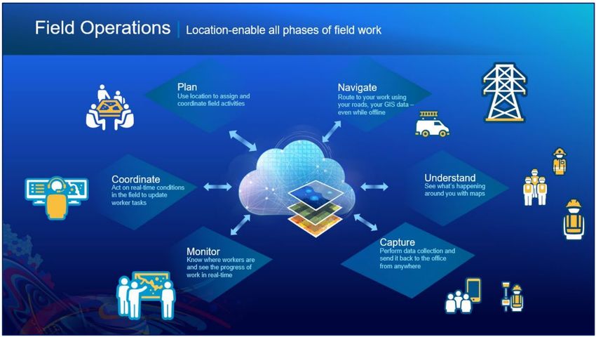
Copyright © 2021 Esri
All rights reserved.
Printed in the United States of America.

The information contained in this document is the exclusive property of Esri. This work is protected under United States copyright
law and other international copyright treaties and conventions. No part of this work may be reproduced or transmitted in any form or
by any means, electronic or mechanical, including photocopying and recording, or by any information storage or retrieval system,
except as expressly permitted in writing by Esri. All requests should be sent to Attention: Contracts and Legal Services Manager,
Esri, 380 New York Street, Redlands, CA 92373-8100 USA.

The information contained in this document is subject to change without notice.

Esri, the Esri globe logo, The Science of Where, ArcGIS, esri.com, and @esri.com are trademarks, service marks, or registered
marks of Esri in the United States, the European Community, or certain other jurisdictions. Other companies and products or
services mentioned herein may be trademarks, service marks, or registered marks of their respective mark owners

                                                                                                                       ii | P a g e
Contents

1     Introduction ................................................................................................................................. 1

2     Background – The Esri Geospatial Cloud ....................................................................................... 1
    2.1      ArcGIS Online ................................................................................................................................ 2
    2.2      ArcGIS Enterprise .......................................................................................................................... 3
    2.3      Hybrid Deployments ..................................................................................................................... 4
    2.4      ArcGIS Mobile Apps ...................................................................................................................... 5

3     Enterprise Mobile App Management ............................................................................................ 8
    3.1      Connecting ArcGIS Mobile Apps to ArcGIS Web Services ............................................................. 8
    3.2      Enterprise Mobility Management (EMM) ..................................................................................... 9
      3.2.1         Mobile Device Management (MDM) .................................................................................. 10
      3.2.2         Mobile Application Management (MAM) ........................................................................... 10
      3.2.3         Mobile Content Management (MCM) ................................................................................ 11
    3.3      EMM and the ArcGIS ................................................................................................................... 11

4     Enterprise Security Mechanisms ................................................................................................. 14
    4.1      Authentication ............................................................................................................................ 14
    4.2      Authorization .............................................................................................................................. 16
      4.2.1         Portal Membership and User Types (Licensing Levels)....................................................... 17
      4.2.2         Portal Member Roles (Permission Levels) .......................................................................... 18
      4.2.3         Portal Groups ...................................................................................................................... 19
    4.3      Security Filters ............................................................................................................................. 20
    4.4      Encryption ................................................................................................................................... 21
    4.5      Certificates .................................................................................................................................. 22
    4.6      Logging and Auditing................................................................................................................... 22

5     Compliance and The Esri GeoSpatial Cloud ................................................................................. 23

                                                                                                                                             iii | P a g e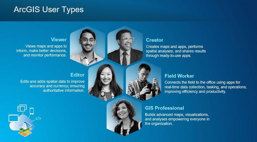
6     ArcGIS Mobile Deployment Patterns .......................................................................................... 24
    6.1      ArcGIS Online .............................................................................................................................. 25
    6.2      Cloud-Based - Esri Managed Services ......................................................................................... 26
    6.3      Cloud-Based - Esri Cloud Images ................................................................................................. 27
    6.4      On-Premises - Reverse Proxy ...................................................................................................... 28
    6.5      On-Premises - Virtual Private Network (VPN) ............................................................................. 29
    6.6      On-Premises - Mobile Security Gateway .................................................................................... 31
    6.7      Hybrid Deployment ..................................................................................................................... 32

7     Conclusion .................................................................................................................................. 33

8     Acronyms ................................................................................................................................... 34

                                                                                                                                          iv | P a g e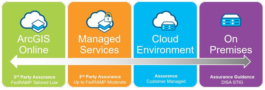
1 Introduction
In recent years, enterprise geographic information system (GIS) deployments have increasingly moved
from traditional office-based workflows to leveraging GIS apps in the field with mobile technology. This
makes security considerations more complex and challenging for information technology (IT) architects
and security specialists to deploy an effective enterprise GIS security strategy. However, industry-
standard security principles and controls can be applied at all levels of ArcGIS architecture to ease this
effort.

This document contains relevant information that helps guide IT managers and GIS administrators in
deploying an enterprise GIS with a mobile field component. This paper discusses several different
deployment scenarios along with some security considerations. The objective is to provide users with
background, tips, and guidance as they implement a secure enterprise GIS solution. This technicalpaper
is a collection of strategies and deployment considerations; it is not a detailed step-by-step
implementation guide. Background knowledge of ArcGIS, IT, and security concepts is not a requirement,
but is strongly recommended. Be advised that enterprise GIS solutions will vary from organization to
organization, and security architects should use the concepts discussed in this document for planning
secure solutions that meet the needs of their specific enterprise GIS implementation.

2 Background – The Esri Geospatial Cloud
The concept of a geospatial cloud combines cloud platform technology with GIS to enable businesses
and organizations to analyze massive amounts of information. The resultant location intelligence often
reveals deeper insights and innovative ways to increase efficiency. A geospatial cloud also allows
location intelligence data to be easily combined with artificial intelligence and predictive analytics. The
Esri Geospatial Cloud is the ArcGIS technology platform delivered at scale and can be leveraged by
organizations of every size from local municipalities to federal agencies and global companies.

One of the key ideas of the Esri Geospatial Cloud is the Web GIS pattern: that all members of an
organization can easily access and use geographic information within a collaborative environment. GIS
analysts still provide technical expertise in the traditional sense, but other staff with little or no GIS
knowledge can also leverage and contribute to their organization's GIS platform. Web GIS leverages
existing GIS investments and makes them discoverable and more accessible. It provides a platform for
integrating GIS with other business systems and promotes cross-organizational collaboration.
Consequently, Web GIS extends the reach of GIS to everyone in an organization, enabling better
decision-making.

From a technology perspective, the Web GIS pattern can be deployed in four ways (see Figure 1):
   • ArcGIS Online: Multi-tenant, software-as-a-service (SaaS)
   • Managed Services: Single-tenant, ArcGIS Enterprise SaaS or Platform-as-a-Service (PaaS)
   • Cloud Environment: Ready-to-deploy ArcGIS Enterprise images for numerous cloud providers
   • On-Premises: ArcGIS Enterprise software installed in an organization’s infrastructure

                                                                                                 1|Page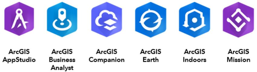
Figure 1: Web GIS Deployment Patterns

Each of the four options support varying levels of risk and offer different security options, which are
discussed in more detail in section 6, and more detailed compliance information is available within the
ArcGIS Trust Center. Although four separate Web GIS deployment models have been defined, hybrid
deployments 1 combining different models are also common. Selecting the appropriate Web GIS
deployment model: ArcGIS Online, managed services, cloud environment, on-premises 2, or a hybrid, will
depend on an organization's business workflows, security requirements, and the available
technology/skill sets within the organization.

2.1 ArcGIS Online
ArcGIS Online is a web-based GIS, hosted by Esri and delivered as a SaaS solution, (see Figure 2). With
ArcGIS Online, organizations can get up and running quickly, and securely 3 create, organize, and manage
geographic information within one system. It connects users in the organization with up-to-date content
including ready-to-use apps, maps, 3D scenes, and layers so they can build useful information products
and accomplish their work more efficiently. It facilitates collaboration and sharing of information with
internal stakeholders, customers, contractors, and the public by providing access to maps, apps, and
data from any device, anywhere, anytime. ArcGIS Online is built on open, scalable technology that
automatically adjusts to meet peak demand periods. ArcGIS Online is Federal Risk and Authorization
Management Program (FedRAMP) 4 Tailored Low SaaS authorized by the United States government for
sharing information with the public. Many organizations with stringent security demands utilize ArcGIS
Online as part of a hybrid deployment described in sections 2.3 and 6.7. Organizations around the world
utilize ArcGIS Online as the FedRAMP security standards map to ISO 27001 Security Controls 5. Though
ArcGIS Online’s cloud infrastructure is located within the United States, ArcGIS Online is General Data
Protection Regulation (GDPR) 6 aligned with a Data Processing Addendum (DPA) available for customers
to sign. For more information on compliance, see section 5.

1 “Hybrid” implies using both ArcGIS Online and ArcGIS Enterprise together – see sections 2.3 and 6.7 for details.
2
  This deployment model is labeled “DISA STIG” – this refers to the “Defense Intelligence Systems Agency (DISA) - Security
Technical Implementation Guide (STIG)” and only applies to the ArcGIS Server component of ArcGIS Enterprise, see section 2.2.
3
  See the ArcGIS Trust Center website and Cloud Security Alliance answers for ArcGIS Online for more details.
4 This is a US federal program for security validation and authorizations – see FedRAMP About Us.
5
  The FedRAMP Tailored Low mapped to ISO 27001 Security Controls is available on Trust.ArcGIS.com.
6
  Learn more about EU GDPR on their site.

                                                                                                                2|Page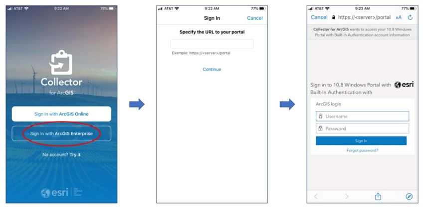
Figure 2: ArcGIS Online Conceptual Diagram (this will be used in later figures)

This option is the easiest in terms of implementation and security consideration perspective because the
solution is hosted and maintained by Esri. An organization does not need to worry about infrastructure
logistics and simply uses ArcGIS Online as a software service. GIS data and content (e.g., maps and apps)
are hosted in Esri’s cloud infrastructure. From a mobile deployment perspective, this is the easiest
deployment option, because mobile devices do not need to connect to an organization’s corporate data
behind a firewall. This is a good solution for field operation workflows, such as capturing the location
and status of assets, marking observations, and sharing information with the public. This may not be a
good solution for multi-user feature update workflows, such as asset inspections, where conflicts may
arise from multiple editors updating the same feature, or updates need to be merged with an existing
production database. Customers risk averse to storing data in cloud-based services frequently
supplement ArcGIS Online with one of the ArcGIS Enterprise deployment models addressed in this
paper.

2.2 ArcGIS Enterprise
ArcGIS Enterprise is the software offering from Esri that enables an organization to use the Web GIS
pattern as managed services, cloud environment, and on-premises solutions. It offers a flexible
deployment model, allowing use that is completely on-premises, connected or disconnected from the
Internet, on physical hardware or in virtualized environments, in the cloud on Amazon Web Services,
Microsoft Azure, or any cloud platform that provides virtual machines that meet the system
requirements and specifications, or as an Esri managed service (see sections 6.2 and 6.3).

ArcGIS Enterprise consists of four components (see Figure 3):

    •    ArcGIS Web Adaptor: Installs in a third-party web server, operates as a reverse proxy
    •    Portal for ArcGIS: Website serving as a central destination and focal point in the Web GIS
    •    ArcGIS Server: Spatial server that enables GIS data and content to be shared as web services
    •    ArcGIS Data Store 7: Back-end repository to store spatial content

                                           Figure 3: Components of ArcGIS Enterprise

7
  The ArcGIS Data Store can be deployed in 3 different ways: relational, tile cache, and spatiotemporal. In this document, we
refer to the relational ArcGIS Data Store (see section 6 for further details). To learn more, see What is ArcGIS Data Store?

                                                                                                                   3|Page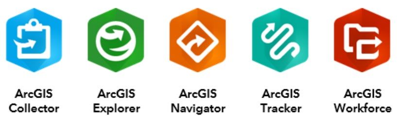
These four components can be deployed in diverse combinations and patterns to support many
different business workflows. In terms of security, both the Portal for ArcGIS and ArcGIS Server
components can support separate security models or share the same security model. A comprehensive
discussion on the different security models that these products support is beyond the scope of this
document. 8 Note: at the ArcGIS Enterprise 10.5 release, the concept of ArcGIS Server licensing roles was
introduced – these “licensing roles” provide additional capabilities and may have some deployment
implications beyond the four components. 9

For the purposes of this paper, the base deployment 10 of ArcGIS Enterprise is referenced. An ArcGIS
Enterprise base deployment implies that all 4 components are deployed together to enable the Web GIS
pattern and leverage the full capabilities of ArcGIS, see Figure 4.

                                         Figure 4: ArcGIS Enterprise Base Deployment

In a base deployment, the ArcGIS Data Store is registered with ArcGIS Server. ArcGIS Server is
federated 11 with Portal for ArcGIS and becomes its hosting server 12 - a dedicated GIS server to support
Portal capabilities such as the Map Viewer analysis tools. Lastly, the ArcGIS Web Adaptor is used by
Portal for ArcGIS and ArcGIS Server, however customers can substitute their own load balancers in place
of utilizing the ArcGIS Web Adaptor. All four components can be installed on the same machine or in a
multi-machine deployment; the latter option is recommended for production deployments.

2.3 Hybrid Deployments
Some organizations choose a combination of deployment models, using a hybrid approach because of
their business requirements. Many different deployment combinations are possible, and this section
presents three examples in brief, see Figure 5.

8 For more product security details see About configuring portal authentication and Control Access in ArcGIS Server.
9
  See ArcGIS Server licensing roles to learn more. Note the term “ArcGIS Server licensing role” is a separate and different
concept than “Portal member roles” which are discussed later in section 4.2.2.
10 To learn more, see Base ArcGIS Enterprise deployment.
11 Where ArcGIS Server has been configured to use Portal for ArcGIS’ security model, see Federate an ArcGIS Server site with

your portal.
12 To learn more, see Configure a hosting server.

                                                                                                                 4|Page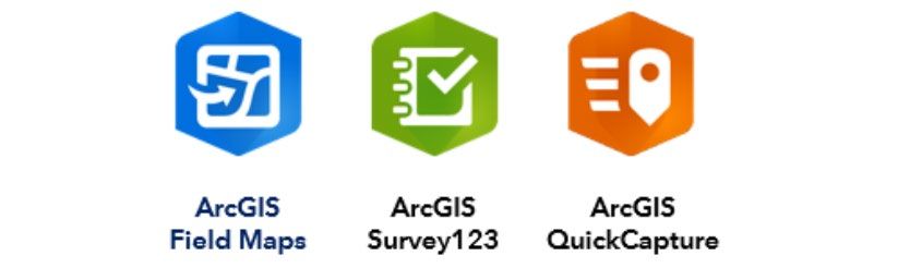
•    Scenario A: ArcGIS Online is used as a front-end website to access GIS assets, while ArcGIS
          Server is used to host web services. GIS data can be shared publicly, but are stored within the
          organization’s infrastructure.
     •    Scenario B: Both ArcGIS Online and ArcGIS Enterprise are used, the former for public 13 content,
          and the latter for sharing content within the organization. Staff can create their own GIS content
          within Portal for ArcGIS. All GIS data are stored within the organization’s infrastructure.
     •    Scenario C: Both ArcGIS Online and ArcGIS Enterprise are used, and distributed collaboration 14 is
          leveraged to integrate GIS data across a network of participants, including those with
          membership in the ArcGIS Online organization, ArcGIS Enterprise, or both.

                       Figure 5: Three Example Hybrid Deployments of ArcGIS Online with ArcGIS Enterprise

There are many other possible hybrid deployment patterns 15 and they will vary based on different
business workflow requirements. Section 6.7 discusses the security considerations for hybrid
deployments.

2.4 ArcGIS Mobile Apps
Smart phones and tablets are pervasive and many enterprise GIS deployments include a mobile
component. ArcGIS Mobile apps support all of the Web GIS deployment models: SaaS, managed
services, cloud environments, on-premises, or a hybrid variation.

ArcGIS Mobile Apps can be grouped into two categories:
   • Field operations mobile apps: Support field operations
   • Solution mobile apps: Support specialized workflows

GIS data and maps can easily be taken into the field to support mobile field workers. Field personnel can
work with the same authoritative datasets on their mobile devices, helping collect new data (or edit
attributes of existing data) that can be easily shared with the office and monitored in real-time by
dispatchers. Field operations tasks include: planning, coordination, navigation, data capture, and
monitoring personnel and assets (see Figure 6).

13
   In this instance, “public” implies end users to are not part of the organization – typically external to the organization’s IT
network.
14
   To learn more about distributed collaboration, see the ArcGIS Online and ArcGIS Enterprise discussions on this topic.
15 Different Web GIS hybrid deployments are presented in Web GIS Patterns and Practices.

                                                                                                                        5|Page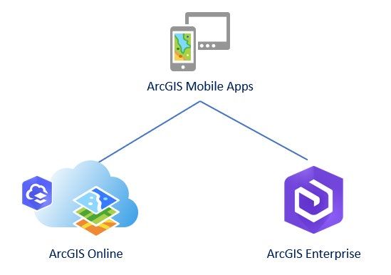
Figure 6: Field Operations in ArcGIS
The ArcGIS field operations mobile apps are available for iOS and Android devices, and some also
support the Windows, macOS and Linux platforms. All ArcGIS Mobile apps sign into and work with
ArcGIS Online and ArcGIS Enterprise 16, see Figure 7. They support connected and disconnected
environments and they can use used separately or collectively as part of a larger mobile workflow,
depending on the organization’s business requirements 17. Enabling a mobile GIS component as part of
an enterprise GIS deployment provides many benefits including:
Replacing redundant inefficient field processes
Reducing costs and overhead
Improving collection speed, accuracy, and currency of data
Modernizing workflows and replacing paper-based workflows
Helping management make timely and informed decisions
ArcGIS field operations mobile apps (see Figure 7a) consist of three main apps:
• ArcGIS Field Maps: Explore maps, collect and update GIS data in the field, and location tracking
• ArcGIS Survey123: Supports form-centric data collection and editing
• ArcGIS QuickCapture: Enables single-button, rapid data collection
Figure 7a: ArcGIS Field Operations Mobile Apps
16 Apps sign into the Portal for ArcGIS component of ArcGIS Enterprise.
17 To learn more about ArcGIS mobile Field Operations, see ArcGIS Apps for the Field: An Introduction.
6|PageArcGIS field operations includes several apps which will be deprecated (see Figure 7b) longer term 18.
• ArcGIS Collector 19: Provides map-centric data collection and editing
• ArcGIS Explorer 20: Supports viewing and markup of GIS maps
• ArcGIS Navigator: Enables routing with turn by turn directions
• ArcGIS Tracker: Enables monitoring personnel and their movement in the field
• ArcGIS Workforce 21: Enables planning and coordinating work assignments
Figure 7b: ArcGIS Field Operations Mobile Apps to Be Deprecated
ArcGIS solution mobile apps are designed to support different business use cases from field operations,
see Figure 8. These apps range from 3D data visualization, to offering a building occupant mobile
experience, to supporting situational awareness scenarios. Some of these are not stand-alone apps but
offered a part of a Geo-Enabled system from Esri. Theare mentioned in this document for
completeness. ArcGIS solution mobile apps include:
• ArcGIS AppStudio Player: Displays custom apps built with ArcGIS AppStudio 22
• ArcGIS Business Analyst Mobile 23: Enables demographic and socio-economic data in the field
• ArcGIS Companion: Enables the management of your ArcGIS organization from a mobile device
• ArcGIS Earth: Displays and provides interaction with 2D and 3D data
• ArcGIS Indoors 24: Displays indoor maps and enables interactions such as searching and getting
landmark based directions
• ArcGIS Mission Responder: Provides mobile workers with situational awareness on a map with
messaging and location tracking among team members.
Figure 8: ArcGIS Solution Mobile Apps
Some apps offer support for more security options (see section 4.1) than others. Please check the online
help documentation for each app for details. 25 While the ArcGIS field apps offered as part of ArcGIS
18
Initial deprecation announcement of December 2021. Please refer to the product life cycle page of each app for status.
19 Note: There are 2 currently offerings of this app: i) Collector Classic and a revised release ii) Collector for ArcGIS.
20 Explorer for ArcGIS can open and view publicaly shared maps without requiring a login for access.
21 Offline support is planned and should be available in 2020.
22 Enables you to create native mobile apps without programming, to learn more see AppStudio for ArcGIS product page.
23 Deploying this app with ArcGIS Enterprise has supplementary requirements, see An overview of Business Analyst Enterprise.
24
ArcGIS Indoors currently only works with ArcGIS Enterprise, the app is part of a larger ArcGIS Indoors solution.
25 Help documentation for the Apps: ArcGIS Help Documentation.
7|Pagemeet the needs of most customers, Esri also offers ArcGIS Runtime Software Developer Kits (SDKs) to
facilitate custom application development. 26 When mobile apps are built with ArcGIS Runtime SDKs, the
concepts regarding enterprise mobile apps discussed in this paper will apply to these custom solutions.
3 Enterprise Mobile App Management
Like other apps in public app stores, the ArcGIS mobile apps are designed for ease of use, allowing
general users to be up and running within minutes. Following the Web GIS pattern, the default
configuration of each ArcGIS mobile app supports the broad dissemination of GIS data and content
across an organization and frequently with the public. If an organization wants to ensure that tighter
enterprise security measures are in place for its mobile solutions, it can apply more stringent controls in
its Web GIS architecture, and include more advanced security components such as enterprise mobility
management (EMM).
3.1 Connecting ArcGIS Mobile Apps to ArcGIS Web Services
Before discussing the details on how an EMM can help, it is useful to define that an enterprise GIS
deployment with a mobile field component is one or more (or all) of the ArcGIS mobile apps connecting
to either ArcGIS Online and/or ArcGIS Enterprise (see Figure 9). This is the Web GIS deployment pattern
with the ArcGIS Platform, supporting GIS workflows in the field.
Figure 9: ArcGIS Mobile Apps Connecting to ArcGIS Online and/or ArcGIS Enterprise
Some common security considerations to support this deployment include:
Will the Web GIS pattern be enabled with ArcGIS Online, ArcGIS Enterprise, or a hybrid
deployment? Refer to section 2.3.
Where will the GIS data and content reside? Can they be stored in the Esri cloud infrastructure,
or must they only reside within the organization’s infrastructure? Can they be a combination of
the two? The nature of the data collected, and the intent of the services used to distribute this
data becomes a critical question.
How will mobile app end users access the organization’s internal network/infrastructure? What
is the organization’s current IT security model/infrastructure? Are there corporate security
policies and/or procedures that must be adhered to?
26
To learn more, see the ArcGIS Developers site.
8|Page When accessing the organization’s internal network, is a single sign-on (SSO) 27 user experience a
requirement?
What hardware resources (e.g., machines and network infrastructure) are available, in terms of
both mobile devices and infrastructure technology?
Does the organization support a bring your own device (BYOD) policy? What are the security
requirements and policies with respect to these devices?
What IT personnel resources are available to support this deployment (in terms of both setup
and maintenance)?
What is the risk tolerance for the organization in terms of the proposed services to be offered?
What are the deployment costs?
The list of questions above is not comprehensive and many of the questions are high level, but they
should be taken into consideration when planning and designing the security model for an enterprise
GIS deployment with a mobile field component. How these questions are answered by senior
management and stakeholders will likely impact which mobile deployment pattern is selected (see
section 6).
There are many potential security risks and mitigations with respect to using mobile technology as part
of an organization’s business workflows. The open web application security project (OWASP) foundation
is a non-profit organization that is “an open community dedicated to enabling organizations to conceive,
develop, acquire, operate, and maintain applications that can be trusted”. 28 In 2016, OWASP finalized
their global study on mobile security and compiled a Top 10 list of Mobile Risks. A discussion on these
items is beyond the scope of this document, but they are noted as a reference source when planning
mobile security strategies. One approach to address these risks is to use an EMM solution in addition to
ArcGIS security settings (discussed in section 4).
3.2 Enterprise Mobility Management (EMM)
When mobile devices are part of an enterprise deployment, the challenge is to ensure that the data and
apps are secure with minimal (or no) impact to the user experience. EMM is a solution strategy for
managing mobile devices, apps, and content in the organization. The main objective is to determine how
mobile devices are integrated with business processes, support field workers, and ensure that IT security
and compliance requirements are met. 29
EMM can be separated into three different conceptual components:
1. Mobile Device Management
2. Mobile Application Management
3. Mobile Content Management
There are many different EMM technology vendors, some have functionality that covers all three
components, while others specialize in one area. Selecting the appropriate one will depend on the
specific security requirements, policies, and business workflows of your organization. Using EMM
technology can provide additional security options at the mobile device level and helps the enterprise
GIS with mobile field component deployment be more secure.
27 SSO means a user would only login once to access resources, see Enterprise Single Sign-On.
28 To learn more, see About The Open Web Application Security Project.
29 To learn more, see How to choose the right enterprise mobility management tool.
9|PageSome key recommendations when deploying an EMM as part of your enterprise GIS mobile deployment:
Develop and deploy a realistic device security policy
o Support for different mobile device operating system (OS) platforms
o Consider BYOD program implications
Provide a backup and recovery service for devices
Require anti-malware software on devices
Perform regular security audits against the EMM solution
Always remove all residual application data from devices when not being used
Implement a staff education program to teach them about mobile device threats
As in section 3.1, the list provided is meant to be used as a starting point for security discussions and
policy planning in your organization.
3.2.1 Mobile Device Management (MDM)
Mobile device management (MDM) is the administration of mobile devices within an organization. This
is typically applied with software that enables the centralization and optimization of functionality and
security management for mobile devices. The software commonly includes a server component that
sends out management commands to mobile devices that have a client component to receive and
execute the management commands. Another key aspect typical of MDM software is the concept of
“containerization”, which means corporate data is separated from a user’s personal data on the mobile
device. MDM software can be used by organizations to deploy apps on their devices by connecting and
working with public app stores.
An MDM solution typically includes the following capabilities:
Device monitoring, reboot, and encryption
Enforcement of password policies, password reset
Predefined WiFi settings/virtual private network (VPN) 30 configurations
Remote lock and wipe capabilities
Backup settings enforcement
Jailbreak detection
An administrator can also use MDM software to define and deploy configuration templates for mobile
devices. The templates can be used to customize the device’s security settings such as: password
requirements; personal identification number (PIN) length; app denylist/allowlist; email configurations;
device encryption; location tracking; WiFi configurations; and app, services, and device feature
restrictions. These options will vary between different MDM software vendors. Please refer to the
ArcGIS Field Apps and Mobile Device Management Support paper for additional details.
3.2.2 Mobile Application Management (MAM)
Mobile application management (MAM) provides an additional level of security for mobile devices; it is
the use of software and services that provision and control access of individual apps on devices. This
enables administrators to have more granular control at the application level to manage and secure app
data. An MDM software solution can include MAM capabilities as part of its functionality.
30 To learn more, see VPNs for Beginners.
10 | P a g eAn MAM solution typically includes the following capabilities:
Application-level authorization and provisioning
App updating
User authentication, access control
App version and configuration management
Push services
Event management
Be advised, Esri has observed that MDM-centric MAM offerings that require rebuilding the app by
embedding the MDM SDK typically do not work well. Esri does have some customers utilizing MAM
offerings that do not require incorporating an MDM SDK. Esri will provide support for released, store
versions, listed within the product’s life cycle support only. In certain cases, Esri Professional Services
can be engaged to help support customer-specific variances if desired.” 31
3.2.3 Mobile Content Management (MCM)
This third component, mobile content management (MCM), is a type of content management system
that stores and delivers content and services to mobile devices.
An MCM solution can have the following capabilities:
Multi-channel content delivery
Content access control
Specialized templating system
Location-based content delivery
This aspect of EMM is not leveraged by the ArcGIS mobile apps.
3.3 EMM and the ArcGIS
It is important to coordinate security implementations of the enterprise GIS with the organization’s IT
department, as an EMM strategy works with more than just the organization’s GIS technology group.
The MDM aspect of the EMM solution is typically the main component that the ArcGIS mobile apps
interact with.
An organization’s MDM software can connect directly to public app stores like the Apple App Store and
Google Play. The ArcGIS mobile apps in the stores can be registered or uploaded (depending on the
MDM vendor) with the MDM. This enables the MDM software to access the apps as resources and can
manage and deploy them to the organization’s mobile workforce. In the MDM software, each app can
be configured to meet the specific security requirements of the organization in which they are used.
When deploying the ArcGIS mobile apps with MDM software, it is recommended that the guidelines
found within the AppConfig Community be followed. This community works with several EMM vendors
and is focused on providing tools and best practices for native capabilities in mobile operating systems,
see Figure 10.
31
While binaries are available for Android OS apps on the Esri website, customers who want to deploy Apple iOS app binaries
will need to agree to supplemental terms in alignment with the Apple Developer terms of use; please consult an Esri account
manager or Distributor.
11 | P a g eFigure 10: AppConfig Community –key concepts 32
The objective of the guidelines are to help provide a more consistent, open and simple way to configure
and secure mobile apps that eases and advances mobile adoption in business. The AppConfig
Community has defined lists of recommended configuration parameters for iOS and Android devices:
• iOS Capabilities Summary
• Android Capabilities Summary
These parameters are meant to guide app developers and help them develop apps that work well in
MDM environments.
The ArcGIS mobile apps development teams strive to follow the recommendations and patterns
provided by the AppConfig Community. In general, ArcGIS mobile apps 33 support the following
capabilities:
• App Configuration: Setting app properties such as URL, port, email address, etc
• App Tunnel: Leverage “per app VPN” capability (secure connection)
• Security Policies & Access Control: Restrict apps to approved devices and enforce policies
• Single-Sign-On (SSO): Provides a user-friendly corporate network sign-on experence
To elaborate on “per app VPN”, this implies that the device will connect to an organization’s VPN to
access internal resources when the app opens. This reduces the inbound connection to the
organization’s internal network to a single app.
In terms of App Configuration settings, most of the ArcGIS mobile apps support the implementation of
the portalURL key. For ArcGIS mobile apps that support this functionality, when the app is opened, it
will bypass the portal URL sign-in screen and display the portal member login screen (see Figure 11). 34
32 Source: AppConfig Community.
33 Exception: ArcGIS Business Analyst does not currently support the App Tunnel property.
34
This workflow is discussed in section 4.1.
12 | P a g eThis means that the ArcGIS mobile apps can be deployed from an MDM with the portal URL address
already configured; when a mobile user opens the app, all they need to input is their login credentials. 35
Responding to user requirements, Navigator for ArcGIS on iOS also supports
enableLocalAuthentication, a setting that enables local authentication within Navigator that
can tie into a device’s FaceID, TouchID, and passcode security settings. 36
The ArcGIS Mobile App Compliance and Security Capability Settings table below summarizes the
FedRAMP compliance status of ArcGIS mobile application API connections to ArcGIS Online as well as
MDM configuration settings. For additional details concerning the MDM settings available for each
mobile app, please refer to the help documentation for each app and the ArcGIS MDM Support
document referenced earlier.
ArcGIS Mobile App Compliance and MDM Settings
A t
l o d F ss
n
q
An iew uth
W ows me
Up loa cce
Da sti Fre
Ex Ma nts
Di d Tr eq
Lo eSig e
LK mo h
ge
rc
ry
A
r
t
l A In
u
no k
s
on Au
qu ou
ac
e
om v e
er
L U us
rta co
an app
t B na
n
ta cs
rta h
p o N am
s
po URL
Sw uth
po MP
Po Ac
Cu tric
Bi eco
re Res
po Aut
ng
om
p
h
di
y
A
e
ir
r
l
l
l
l
l
a
r
v
rta
rta
rta
itc
dR
eb
ca
ag
st
App
Fe
Br
ArcGIS Field Maps *
ArcGIS Survey123
ArcGIS QuickCapture
ArcGIS Collector
ArcGIS Explorer
ArcGIS Navigator
ArcGIS Tracker
ArcGIS Workforce
ArcGIS AppStudio Player
ArcGIS Business Analyst Mobile
ArcGIS Companion
ArcGIS Earth P
ArcGIS Indoors P
ArcGIS Mission Responder P
* = Limited to capabilities not utilizing Location Tracking
P = Planned
ArcGIS mobile apps have been successfully deployed with an EMM strategy by many customers.
Examples of MDM vendor solutions used include: AirWatch, F5 Big IP, InTune, MaaS360, Meraki,
MobileIron, and XenMobile. The ArcGIS mobile apps are frequently updated and are continually working
to support additional capabilities in future releases.
Deploying an EMM solution as part of your enterprise GIS with a mobile field component is not required,
and if not, security efforts should focus on topics discussed in the next section. Independent of having
an EMM solution, customers should still implement the Enterprise Security Mechanisms in section 4.
35
Implementation details are covered in the blog: MDM and Explorer for ArcGIS.
36
Learn more in the blog: Navigator supports enhanced security – and it’s configurable with your MDM!
13 | P a g e4 Enterprise Security Mechanisms
In this section, common security mechanisms utilized across an enterprise are discussed in the context
of the ArcGIS. Esri recognizes the challenges encountered when deploying an enterprise GIS with a
mobile field component and is committed to help customers determine how to best apply these security
practices to their GIS implementations.
4.1 Authentication
When using the ArcGIS mobile apps, a user specifies if they are connecting to ArcGIS Online or ArcGIS
Enterprise. 37 In the latter case, they would input a portal URL address. 38 Next, the user provides login
credentials to access the portal and its content. 39 An example of the login workflow is shown with
Collector for ArcGIS in Figure 11.
Figure 11: ArcGIS Collector – ArcGIS Enterprise login dialogs
Authentication is the process of verifying the identity of a user by checking their credentials. In the
context of ArcGIS mobile apps, the user is authenticated by a customer’s identity provider, ArcGIS
Online, and/or ArcGIS Enterprise (see Figure 9). After a user is authenticated, ArcGIS Online or ArcGIS
Enterprise then performs an authorization check to determine which actions the user can perform (see
section 4.2).
Based on successful authentication, the applications generate an authorization token for future
transactions. All requests, including authentication requests, are done in Hypertext Transfer Protocol
Security (HTTPS) 40 protocols. The enterprise GIS with mobile field app solution should be considered
with several factors in mind:
What types of mobile devices will access the GIS data and content?
What authentication mechanisms do the mobile devices support?
Does the enterprise system have authentication mechanisms already in place?
Does the IT enterprise system have specific HTTPS authentication requirements?
37
Note that a login to ArcGIS Online is a different account than a login to ArcGIS Enterprise; they are two separate and distinct
accounts.
38
To learn more, see Portal for ArcGIS URLs help topic.
39
Exception: Explorer for ArcGIS can access publicly shared content without a login.
40 To learn more, see What is HTTPS?.
14 | P a g e Does the organization have specific methods for providing enterprise network credentials (e.g.,
VPN 41, SAML 42 or mobile security gateway 43)?
When a mobile device attempts to access a secured GIS resource, it needs to provide credentials to
ensure it has the appropriate permissions. The mobile device’s credentials could be the same as the
user’s enterprise network login 44 info (i.e., SSO authentication), or additional credentials could be
required to access the secured GIS resource. Typically, an organization’s security level requirements will
determine which option is used – this relates back to the previous list of questions.
Note: Unsecured GIS resources (i.e., content shared with the “public”) are typically set to Anonymous
access (as these do not require a login to access). Configuring a publicly accessible application to protect
data collected from users can be challenging. A separate paper addresses this scenario for Survey123
called “Discovering and Limiting Access to Public Survey123 Results”.
Caution: Using webhooks with ArcGIS applications can accelerate the process to integrate capabilities
from third-party providers, however, they bring up significant security and privacy challenges that
require extensive efforts to mitigate associated risks. We strongly recommend that customers validate
any third parties utilized as part of a webhook workflow are approved by their organizations for
handling sensitive information such as credentials or datasets before incorporating them. Additionally,
we suggest reviewing and incorporating the recommendations from OWASP’s lastest draft of the
“Webhook Security Guidelines Cheat Sheet”.
ArcGIS Online has three authentication options:
Security Option Comments
Built-in security This is the default built-in security model where user and role
information is stored within ArcGIS Online. Mobile devices connect
to ArcGIS Online and provide credentials.
Organization-specific logins In this option, the ArcGIS Online organization is registered with a
with security assertion markup third-party identity provider (IDP) to verify credentials. Users
language (SAML) requesting to login are directed to the IDP. They log in to the IDP,
authentication or OpenID which verifies their credentials and provides an authentication
Connect token to allow them to login to ArcGIS Online.
Social Logins Authentication via a social network like Google or Facebook.
ArcGIS Enterprise (via the Portal for ArcGIS component 45) offers several authentication options:
Security Option Comments
Web-tier authentication 46
This uses integrated Windows authentication (IWA) or Lightweight
Directory Access Protocol (LDAP) 47, which provides a SSO user
experience in Windows-based environments. In this option, a login
is requested when the user connects to the ArcGIS Web Adaptor,
which is connected to the Windows Active Directory or LDAP
41 See details in section 6.5.
42 SAML – Security Assertion Markup Language; to learn more, see SAML v2.0 specification.
43 See details in section 6.6.
44
See Esri Software Security & Privacy (SSP) FAQ document Organization-Specific Logins FAQ.
45 ArcGIS Server must be federated with Portal for ArcGIS to enable a hosting server deployment. See footnote 13 for details.
46 ArcGIS Enterprise supports public key infrastructure (PKI) authentication, but only Collector for ArcGIS on iOS supports this
option – see Configure Collector help topic.
47 To learn more, see Integrated Windows Authentication and What is LDAP?.
15 | P a g eserver for validation. When mobile devices access the internal
enterprise network, they will automatically have access to the
Portal for ArcGIS website.
Portal-tier authentication Default built-in security model where user and role information is
stored within Portal for ArcGIS.
This approach uses tokens that enables a client to access a secure
GIS resource. Mobile devices access the internal enterprise
network, then when they attempt to connect to Portal for
ArcGIS 48, they need to provide a valid portal named user account.
Organization-specific logins In this option, Portal for ArcGIS is registered with a third-party IDP
with SAML authentication or to verify credentials. Users requesting a login are directed to the
OpenID Connect IDP. They log into the IDP which verifies their credentials and
provides an authentication token to allow them to login to portal
and access resources that have been provisioned to them.
User credential information is stored in an identity store 49: a list of valid users who can access the
enterprise network. A user’s identity is typically comprised of unique information (e.g., name, email,
password, etc.) and their membership in roles. Enterprise systems typically have two “categories” of
identity stores:
• Users: End user of a client application accessing network and identified by a set of credentials.
• Role: Set of privileges; users in the same role have the same permissions assigned.
A user can only belong to one role, and a role typically contains multiple users. Users and roles could be
stored in the same or separate identity stores. Two frequently used identity store options in enterprise
systems are Active Directory for Windows domains and LDAP for Linux-based domains. Note that ArcGIS
Enterprise on Kubernetes supports Portal-tier authentication and Organization-specific login methods
listed in the table above. For more information refer to the ArcGIS Enterprise on Kubernetes FAQ.
4.2 Authorization
After a user has been authenticated, the authorization model will determine what resources the user
can access within the ArcGIS, and what operations or actions they can perform. Users should be
assigned privileges based on roles and should follow the principle of least privilege: they should only be
able to access the information and resources necessary for their legitimate purposes. For both ArcGIS
Online and ArcGIS Enterprise (Portal for ArcGIS component), the central destination homepage is often
called the portal. Items in the portal such as web apps, web maps, web scenes, and web layers can be
logically aggregated into groups for organizational purposes (see section 4.2.3). Groups 50 in the portal
can be leveraged to help control user access to different types of GIS data and contents in the
organization, see Figure 12.
48
The logins are typically enterprise users (e.g., Windows Active Directory or LDAP) as the identity store. Built-in named users
(who are not enterprise users) could also be used, but will not have a SSO user experience.
49 This is also sometimes termed “identity provider”.
50 To learn more about Groups in a portal, see What is a group?
16 | P a g eFigure 12: Configuring Authorization Settings
In this technical paper, a portal named user account in the portal will be called a “portal member”, and
they are assigned a user type and role. User types are assigned to portal members based on their work
duties and portal roles define specific functionality.
4.2.1 Portal Membership and User Types (Licensing Levels)
In the December 2018 ArcGIS Online update and at the ArcGIS Enterprise 10.7 release, the concept of
user types was introduced. 51 User types enable administrators to provide more granular control over the
deployment of portal members and can help minimize the costs for user accounts. A user type is
selected for a portal member based on an assessment of their role in an organization, work duties, and
how they will use the portal (see Figure 13). A user type defines a portal member’s capabilities in the
portal and access to certain ArcGIS client apps. There are five core user types 52:
• Viewer - Viewers can view items that are shared with them by other ArcGIS users. They can’t
create, edit, share, or perform analysis on items or data.
• Editor - Editors can view and edit data in ArcGIS maps and apps that are shared with them by
other ArcGIS users. They can also be used with custom editing applications created by
customers or by Esri business partners. Editors can’t analyze, create, or share items or data.
• Field Worker - Field Workers can view and edit data that has been shared with them by other
ArcGIS users. Ideal for portal members who primarily interact with ArcGIS content through
ArcGIS field apps. They can’t analyze, create, or share items or data.
• Creator - Creators have all the capabilities of the Viewer, Editor, and Field Worker user types,
plus the ability to create content, administer the organization, and share content. This user type
is designed for those who need to create web maps and apps, perform in-depth spatial analysis
using the analysis tools in the portal, and work with data using ArcGIS field apps.
• GIS Professional - GIS Professionals have all the capabilities and app bundles of the Creator, plus
access to ArcGIS Pro (Basic, Standard, or Advanced). This user type is designed for those who
need the full suite of GIS apps to perform their work.
51
To learn more about User Types, see 10.7 help topic User types, roles, and privileges.
52
Additional user types exist for more specialized workflows and others may be introduced by Esri in the future.
17 | P a g eFigure 13: Core ArcGIS User Types
For an enterprise GIS deployment with a mobile field component, the Field Worker user type is an
important consideration and would be the most applicable to support field operation workflows (shown
in Figure 6). This user type includes access to: Workforce for ArcGIS, Collector for ArcGIS, Survey123 for
ArcGIS, and ArcGIS QuickCapture. This would be the user type typically assigned to personnel working in
the field with the ArcGIS field apps. For example, field crew staff who perform data collection and asset
management inspections.
Please review the help topic referenced in footnote 54 for a comprehensive description of the five core
user types available in a portal. Ensuring portal members are assigned the appropriate user type before
they interact with the portal is strongly recommended.
For pre-10.7 versions of ArcGIS Enterprise, portal membership is defined by two license levels 53:
• Level 1: Members who only need privileges to view content, such as maps and apps, that have
been shared with them through the organization, or to join groups within the organization.
• Level 2: Members who need to view, create, and share content and their own groups, and
perform other tasks.
Most of the ArcGIS field apps involve data collection; therefore, field users should be assigned level 2
membership.
4.2.2 Portal Member Roles (Permission Levels)
A portal member’s role defines the set of privileges assigned to the member. There are several default
roles available in a portal:
• Viewer: View items such as maps, apps, scenes, and layers that have been shared with the
public, the organization, or a group to which the member belongs. Join groups owned by the
organization. Drag CSV, text, or GPX files into the Map Viewer to geocode addresses or place
53
To learn more about portal levels, see 10.6 help topic Levels, roles, and privileges.
18 | P a g enames. Get directions in Map Viewer and apps. Members assigned the Viewer role cannot
create or share content or perform analysis. The Viewer role is compatible with all user types.
• Data Editor: Viewer privileges plus the ability to edit features shared by other portal users. The
Data Editor role is compatible with all user types except Viewer.
• User: Data Editor privileges plus the ability to create groups and content; use the organization's
maps, apps, layers, and tools, and join groups that allow members to update all items in the
group. Members assigned the User role can also create maps and apps, edit features, add items
to the portal, share content, and create groups. The User role is compatible with the Creator
and GIS Professional user types.
• Publisher: User privileges plus the ability to publish hosted web layers, GIS Server layers,
register data stores, publish from data store items, and perform feature and raster analysis. The
Publisher role is compatible with the Creator and GIS Professional user types.
• Administrator: Publisher privileges plus privileges to manage the organization and other portal
users. An organization must have at least one administrator, though two is recommended.
There is no limit to the number of members who can be assigned to the Administrator role
within an organization. However, for security reasons, this role should only be assigned to those
who require the additional privileges associated with it. The Administrator role is compatible
with the Creator and GIS Professional user types.
This list of user roles are the default roles available in ArcGIS Online and ArcGIS Enterprise (Portal for
ArcGIS component). 54 However, portal administrators can also create and define custom user roles 55 –
which provides them with more granular control on permission settings for their users. Please review
the help topic referenced in footnote 54 for a comprehensive description of the different user roles
available in a portal.
4.2.3 Portal Groups
A portal group is a set of users that share access to the same collection of portal items. Groups can be
used to help control access to items in the portal, because they help to organize portal content. 56
Groups and their contents are public by default and portal members are given access by the group
owner. Groups can be configured to be seen in several ways:
• Only group members - Only members of the group can find and view the group. Portal
members will need to be explicitly invited to join the group.
• People in the organization - Only members of the organization can find and view the group.
Members can be invited to the group or apply to join.
• Everyone (public) - Anyone with access to the portal, even if they are not a member of the
portal organization, can search for and view the group and access any content that is shared
with both the group and the public. This is the default setting.
This portal feature helps implement and apply governance policies for portal members. Groups can be
modeled in many ways and should be utilized based on the best implementation that meets an
organization’s business requirements. For example, groups could be based on different departments
within an organization, different teams, or project stage.
54
Pre-ArcGIS Enterprise 10.7 releases may not support all the roles listed in this section.
55 To learn more, see Custom roles.
56
See footnote 53 to learn more.
19 | P a g e4.3 Security Filters
For ArcGIS Enterprise deployments, another aspect to consider is the enterprise network
implementation. Specifically, organizations can apply standard server-side hardening recommendations
that align with industry best practices. A comprehensive discussion on this topic is beyond the scope of
this technical paper, but typical strategies include applying the following:
• Firewalls: A network security system that monitors the inbound and outbound network traffic based
on a predefined set of security rules. 57 The ArcGIS Enterprise help documentation discusses using
firewalls for both physical and cloud deployments. 58
• Web Application Firewalls (WAF) 59: A WAF filters, monitors, and blocks traffic to and from a web
application. It is different from a regular firewall in that it can filter the content of specific web
applications, while regular firewalls serve as a safety gate between servers.
• Demilitarized zone (DMZ) 60: A physical or logical sub-network containing elements that are
exposed to the Internet within the internal enterprise network. Typically, only a single endpoint on
the DMZ is exposed to the external Internet. A DMZ helps provide an additional security layer to an
organization’s local area network (LAN).
For example, in Figure 14, one strategy is to deploy the ArcGIS Web Adaptor on a third-party web server;
both are in the DMZ, while the remaining ArcGIS Enterprise components are located behind a firewall
(or a WAF) beyond the DMZ. This ensures that Portal for ArcGIS, ArcGIS Server, and the ArcGIS Data
Store are protected behind multiple firewalls. Note: this is a simplified example and not a
comprehenisive discussion on deploying ArcGIS Enterprise components in the DMZ. Organizations
should discuss their specific security and IT requirements with appropriate Esri personnel such as a
solution architects and technical advisors. More on this deployment will be covered in section 6.4.
Figure 14: ArcGIS Enterprise firewall and DMZ deployment
57 To learn more, see What is a firewall?.
58
To learn more, see Firewalls and ArcGIS Server and Windows Firewall and the Esri AMIs.
59
To learn more, see Web Application Firewall (WAF).
60 To learn more, see DMZ (Computer Networking).
20 | P a g eYou can also read