ArcUser Climate Action: Reasons for Hope 32 - Networking Is Key to Building a GIS Career 54
←
→
Page content transcription
If your browser does not render page correctly, please read the page content below

Winter 2023

ArcUser
The Magazine for Esri Software Users

Climate Action:
Reasons for Hope           32

Networking Is Key to Building
a GIS Career 54
Drone Mapping and AI
Combine to Find Flood Victims
Faster in Mozambique 66


Contents                     Winter 2023 Vol. 26 No. 1

     Focus
     8   Improved Location Accuracy Enables Hydraulic
         Modeling
     12 Geoenabling the Modern Water Utility

     14 New Schema Shines for State Geological Agencies

14

     Special Section
     32 Climate Action: Reasons for Hope

32

     End Notes
     66 Drone Mapping and AI Combine to Find Flood Victims
         Faster in Mozambique

66

                                esri.com/arcuser Winter 2023 au   3
Providing Insight,                                                                           ArcUser
Enabling Action                                                                              Winter 2023 Vol. 26 No. 1

The increase in the number of extreme weather events in 2022 has brought home the
reality of climate change.                                                                   Editorial
   From May through September, heat waves blistered communities across the United            Editor Monica Pratt
                                                                                             Contributors Matthew Lewin, Keith Cooke,
States. In Europe, the worst drought in 500 years and a heat wave that broke high
                                                                                             Greg Milner, Crista Campbell
temperature records exacerbated wildfires that blazed in France, Spain, and Portugal.        Technical Adviser Paul Dodd
Hurricane Ian, which hammered Florida and South Carolina, caused the second-largest          Copyediting Allan Mendiola
insured loss on record.
                                                                                             Design
   These are just a few examples of weather patterns that have become more extreme,
                                                                                             Creative Director James Hitchcock
devastating, and—unfortunately—more common. As extreme weather events become                 Designer Doug Huibregtse
more pervasive, the need to deal with them becomes increasingly urgent.                      Illustrator Dan Gill
   In “Climate Action: Reasons for Hope,” Esri chief scientist Dawn Wright highlighted       Photographers Rachel Kinney, Eric Laycock
some of the ways the geographic approach and GIS are helping reveal the causes               Print Coordinator Lilia Arias
of climate change, focus mitigation efforts, and evaluate and integrate all available
                                                                                             Advisory Board
resources to build a more resilient and sustainable world.                                   Corporate Marianna Kantor
   Articles in this issue demonstrate the numerous ways GIS is being used to address         Products Damian Spangrud
aspects of climate change. For example, GIS played a vital role in responding to epic        International Dean Angelides
flooding in Mozambique. Using drone-captured imagery and artificial intelligence,            Marketing Communications Jeff Brazil
people trapped by floodwaters were more quickly found and rescued.                           Industries Damian Spangrud
   GIS also has a vital role before disasters to identify mitigation strategies that will
lessen the impact of these events. After disasters, GIS can assist in not only responding
to events, but also in coordinating the work of building back communities so that they
are more resilient. Through building digital twins in GIS, all communities can access        Read ArcUser Online
tools to better understand threats, marshal resources, and model scenarios for build-        Visit the ArcUser website (www.esri.com/
                                                                                             arcuser) to download tutorials, read current and
ing communities that are equitable, attractive, and sustainable.
                                                                                             past issues, and access additional resources.
   The tangle of challenges the world faces now are the product of decisions that were
made in isolation, bereft of the context that would illuminate their far-reaching effects.   Subscribe to ArcUser
                                                                                             Residents of the United States can
We need to think about these challenges in new ways. The geographic approach,
                                                                                             subscribe to the print edition of ArcUser at
implemented through GIS, provides new ways to see and think about the world’s                go.esri.com/subscribe.
problems, collaborate, and devise solutions. The constantly expanding capabilities of
ArcGIS to integrate, analyze, visualize, and model data are enabling insight into com-       Manage Your ArcUser Subscription
plex phenomena such as weather and ocean systems. This understanding is vital to             Make changes to your subscription information
                                                                                             at go.esri.com/manage-subscriptions.
meeting the current and future challenges of climate change.
                                                                                             Advertise in ArcUser
                                                                                             For information regarding placing an
                                                                                             advertisement in ArcUser magazine, contact
                                                                                             the advertising coordinator at ads@esri.com.

Monica Pratt                                                                                 Editorial Inquiries
ArcUser Editor                                                                               Monica Pratt, ArcUser Editor
                                                                                             380 New York Street
                                                                                             Redlands, CA 92373-8100 usa
                                                                                             arcuser_editor @esri.com

                                                                                             Become a Contributor
                                                                                             Read the publication's guidelines at
                                                                                             https://bit.ly/3mwMRxc.

                                                                                             ISSN 1534-5467
                                                                                             ArcUser is published quarterly by Esri at
                                                                                             380 New York Street, Redlands, CA 92373-8100        usa.
                                                                                             ArcUser is written for users of Esri software and
                                                                                             distributed free of charge to registered users.

4    au Winter 2023 esri.com/arcuser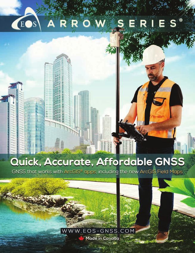
Departments
     Software and Data
     6   Briefly Noted

     Manager’s Corner
     16 Understanding Current Assets and Future Needs with
         Digital Twins
     22 Is Your Geospatial Strategy Aligned with the Rest of
         Your Business?

     Developer’s Section
     26 Introducing ArcGIS Maps SDKs

     28 Visualizing Multidimensional Datasets with ArcGIS
16       Maps SDK for JavaScript

     Hands On
     38 How Aggregation Resolves Reliability Concerns for
         American Community Survey Data
     42 Five Great Ways to Use Data Loading Tools

     46 Control Imagery Visualization with Dynamic Imagery
         Layers
     50 Save Smart & Save Time

     Bookshelf
     52 Creating a Smarter Campus: GIS for Education

     52 Spatial Business: Competing and Leading with
         Location Analytics

46   52 Preserving Our Planet: GIS for Conservation

     Faces of GIS
     54 Networking Is Key to Building a GIS Career

     57 Boost Your Career

     58 30 Tips for Networking at Conferences and Other
         Events

     Education
     60 Arizona State University Expands Its Location Analytics

     62 Students Protect the Unhoused from Wildfires

     64 The US Department of Education Ed Prizes

54

                                esri.com/arcuser Winter 2023 au   5
Briefly Noted
Esri Named Leader in Understanding Climate
Risk
Independent research firm Forrester recognized Esri as a leader in offering advanced
data processing and visualization to help decision-makers tackle climate risks in its report,
The Forrester New Wave: Climate Risk Analytics, Q4 2022. Esri received a differentiated
rating—the highest score possible—in 9 out of 10 criteria, including advanced data pro-
cessing, visualization, and threat modeling. The report notes, “If you have physical assets
that could be threatened by climate, Esri can bring the data and processes to bear to
target operational resiliency opportunities.”
Scalable Geospatial Analysis in a Data Science
Workflow
ArcGIS GeoAnalytics Engine can be plugged into Databricks architecture to extend
cloud-based geospatial capabilities for organizations that need big data spatial solutions
at speed and scale. This engine is a plug-in for Apache Spark that extends data frames
with very fast spatial processing and analytics and is ready to run in Databricks. ArcGIS
GeoAnalytics Engine allows data scientists, engineers, and analysts to analyze geospatial
data within their existing big data analysis environments. To read more about these use
cases, see https://bit.ly/3BxySkG.
World Terrestrial Ecosystems Map Released â The World Terrestrial Ecosystems Map,
available through ArcGIS Living Atlas of
In partnership with Esri and The Nature Conservancy, the US Geological Survey (USGS) the World, breaks up landmass by areas of
launched the World Terrestrial Ecosystems Map, which breaks up the globe not by po- similar climate, landform, and land cover.
litical boundaries but instead by areas of
similar climate, landform, and land cover.
“Ecosystems give us goods and services like
food, water, [and] fuel…so we need to take
care of them,” said Dr. Roger Sayre, senior
scientist for ecosystems at USGS and the
lead on the project. “A requirement for
managing ecosystems is first knowing
what they are and where they are on the
planet. That’s why we classify and map eco-
systems.” The map—which is available in
ArcGIS Living Atlas of the World and as an
explorer tool at rmgsc.cr.usgs.gov/wtee—
can be used for conservation planning,
analyzing ecosystem health and resilience,
formulating how to make progress toward
achieving the United Nations Sustainable
Development Goals (SDGs), and more.
6 au Winter 2023 esri.com/arcuser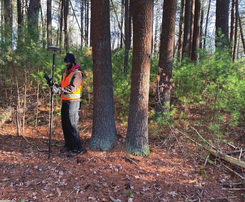
Software and Data
GeoAI Helps Develop
Sustainable Agriculture
in Africa
To aid government and nonprofit organiza-
tions in Africa in addressing acute challeng-
es related to climate change, including low
agricultural yields and heavily degraded
soils, Esri is collaborating with Microsoft to
develop GIS-based crop mapping and land
management technology. The tools com-
bine Esri’s geospatial artificial intelligence
(GeoAI) capabilities with satellite imagery
and Microsoft’s infrastructure and AI devic-
es to provide deeper understanding of the
agricultural landscape across the continent.
There is a great need to improve agricul-
tural productivity in Africa. Combining Esri’s GeoAI capabilities and satellite imagery, as well Combining GeoAI capabilities and
as Microsoft’s infrastructure and AI devices, will help build a deeper understanding of the satellite imagery with Microsoft’s
infrastructure and AI devices will help build
current agricultural landscape, enable closer monitoring of crop conditions throughout the a deeper understanding of the current
growing season, and suppport the mitigation of climate change impacts. This will contribute agricultural landscape in Africa and improve
to better production and food security. To learn more about how location intelligence can agricultural yields.
power global land monitoring, visit https://bit.ly/3VUlM95.
Esri Extends Its Collaboration with Geneva
Demining Center
Removing land mines and other explosive ordnance from former war zones is an inher-
ently geographic problem. Humanitarian organizations that perform demining are relying
increasingly on digital technology, especially GIS, to support these endeavors. Esri and
the Geneva International Centre for Humanitarian Demining (GICHD) have renewed and
expanded their partnership through a memorandum of understanding (MOU).
Humanitarian organizations, which have been using GIS for more than two decades,
will continue using Esri’s technology to map explosive ordnance to more precisely clear
it and ultimately help people return to their homes and use their land safely. Esri will sup-
port modernization of the Information Management System for Mine Action (IMSMA), the
GICHD flagship platform, used by more than 80 percent of national and United Nations
mine action programs globally.
Built using Esri’s GIS software, the platform serves a critical purpose in the demining
process by providing information access to a wide range of stakeholders, as well as real-
time visualization and reports on the extent of contamination in specific locations. To
learn more about how GIS tools can help humanitarian organizations, visit esri.com/en-us/
industries/humanitarian/overview.
esri.com/arcuser Winter 2023 au 7
Improved Location Accuracy
Enables Hydraulic Modeling
By Christa Campbell

A water district in Kentucky increased the locational accuracy of assets in its
GIS using mobile mapping so that its engineering team could use the data
for hydraulic modeling. GIS also helps the district streamline operations
and improve customer service.

Warren County Water District (WCWD),              manages the water systems for Simpson             original as-built drawings. Now engineers
based in south central Kentucky, offers           County Water District and Butler County           can access the drawings by selecting an
water and wastewater services over a              Water System through a joint operations           asset to open its pop-up and then clicking
530 square mile area between Nashville            agreement that brings the total length of         a hyperlink from the attributes. The hy-
and Louisville. Every day, the utility delivers   water main to just over 2,100 miles across        perlink launches an internal web mapping
more than 8.1 million gallons of drinking         1,200 square miles. Each of the three utilities   application where historical data can be
water across 1,194 miles of water lines, while    has a separate board of directors, but their      viewed.
its wastewater system transports 2 million        operations are streamlined through GIS and
gallons of wastewater across 218 miles of         one customer information system (CIS).            The Original Move to GIS
sewer line.                                          When moving from paper map books               In the past, WCWD used to equip its field
   In addition to this system, WCWD               to web maps, WCWD digitized its                   crews with 75-pound paper map books

â WCWD digitized its original as-built drawings, which can be accessed via a hyperlink that launches an internal web mapping application
containing historical data.

8    au Winter 2023 esri.com/arcuser

Focus
to navigate to service order work sites. quality that his engineers could use. His
Although the map books got the job next challenge was to find a simpler way to
done, they were cumbersome and time- maintain this level of accuracy in-house—
consuming to use—especially for new and potentially expand it to all assets.
employees. Additionally, in 2009 WCWD had
In 2006, WCWD decided to modernize begun utilizing GIS data in the field with a
its operations and hired its first full-time Windows-based mapping application on
GIS employee along with a contractor to laptops. While the laptops were a great
kick-start digital mapping. First, WCWD tool, mobility in the field was limited to the
digitized thousands of paper as-built draw- truck. Malone believed the new in-house
ings and georeferenced them to GIS fea- mobile mapping solution could overcome
tures. The contractor then went to the field both remaining challenges.
to map all the aboveground assets, using
subfoot-grade mapping equipment. Real-Time, Accurate Mobile
Once the locations were postprocessed, Data Collection with ArcGIS
WCWD IT and GIS manager B. J. Malone Around this time, Malone noticed Esri’s
uploaded them into the GIS and snapped mobile data-collection apps were becom-
features to the new accurate locations. ing not only very popular but also incred-
Malone and the contractor mapped the ibly robust. Originally, Collector for ArcGIS
WCWD system. Subsequently, Malone and later ArcGIS Field Maps, combined
brought field mapping in-house to map with ArcGIS Survey123, could enable GPS-
the Simpson County and Butler County supported data collection directly into the
systems. GIS, in real time and with the data already
“At that point, we had all of our above- in GIS format.
ground assets—every valve, meter, pump “We already had Esri software, so mi-
station, hydrant, and maintenance hole— grating to Esri mobile apps made sense to
mapped with subfoot accuracy,” Malone us,” Malone said. “Everything was native to
said. the GIS format, and it enabled us to give
Before WCWD switched to high-accuracy
our [staff] in the field something with GPS digital maps running on mobile devices,
Hydraulic Modeling for capabilities on a device they were comfort- field crews used these 75-pound map books
Wastewater Assets able using.” The utility gave its field crews for navigation during service calls and
routine work.
Subfoot asset accuracy was acceptable both iOS and Android tablets—based on
for mobile workers, but it was not good user preference—running Esri apps.
enough for the engineering team to use The last remaining component was a time-saver for us with both data collection
in hydraulic modeling. Hydraulic modeling compatible, centimeter-grade Global and postprocessing,” WCWD GIS analyst
relies on extremely accurate elevation Navigation Satellite System (GNSS) re- Josh Smith said. “It streamlined both office
values that would require centimeter-level ceiver that worked with the ArcGIS apps. and [mobile] workflows by keeping every-
accuracy in the GIS. After consulting with a nearby water thing in one place and eliminating the need
Extracting elevation values from paper district, Malone chose the Arrow Series to pass data through multiple applications.”
as-builts was time-consuming and some- GNSS receivers made by Esri partner Eos The Arrow Gold receiver also offered a
times frustrating for WCWD’s engineers. Positioning Systems. The Arrow Gold feature for maintaining survey-grade accu-
The drawings often contained inaccurate receiver provides real-time, centimeter- racy in remote areas where internet service
slope measurements. Malone realized that grade locations through a combination of via the cellular network was spotty.
WCWD could benefit from improving the GNSS positioning and real-time kinematic “We went to some of the most remote
accuracy of its GIS data even further. (RTK) differential correction processing. It areas of our system to test out the Arrow
To test the idea, Malone hired another could be used with the Kentucky Real Time GNSS receiver, and it just worked,” Malone
contractor to remap the utility’s wastewater Reference Network, the local free RTK said.
assets with centimeter-grade accuracy. In network. Going this route would eliminate
this pilot project, the collected data had both postprocessing and manual data up- Streamlined Data for Hydraulic
to be postprocessed to obtain the desired loads to the GIS. Modeling
accuracy, before being imported to update “When Eos came along and made that Today, WCWD has mapped its wastewa-
the GIS. When these tasks were completed, marriage with Esri so that everything works ter assets with centimeter-grade accuracy,
Malone had the information at a level of natively in Esri apps, that became a huge and its aboveground assets—for all three
esri.com/arcuser Winter 2023 au 9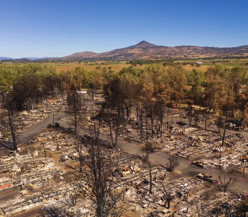
Within ArcGIS Field Maps, service crews can select a hydrant and then launch a hydrant
flow testing form within ArcGIS Survey123. A dashboard, created using ArcGIS Dashboards,
shows the results of hydrant flow tests.
systems—with subfoot accuracy. This year its underground assets. Today, developers
The field team members have also start-
WCWD staff have deployed RTK data col- ed to realize gains from having accurate,and inspectors are equipped with ArcGIS
lection for all newly constructed assets. digital maps with them at all times. TheyField Maps and Arrow Gold receivers to
Meanwhile, engineers have engaged a map assets in new subdivisions before they
are able to find things faster and can access
consultant who will now use RTK elevations are buried.
what they need on one device. It has eased
to develop a wastewater hydraulic model. everybody’s mind. For call-before-you-dig requests to
The engineers are already using the data WCWD has since hired one more full- locate existing assets, WCWD equipped
for other workflows, such as system-modi- time GIS employee to support Malone. its asset-locating teams with the same
fication planning and historic leak tracking. The district estimates that of the 74 em-technology. The teams now use the maps
ployees at the utility, 65 to 70 use GIS of aboveground assets (e.g., valves, meters)
regularly. The meter-reading team mem- to more quickly find buried water mains. In
“
bers use the maps to navigate to existingplaces where underground assets are al-
meters and aid the installation of 41,000ready mapped, the teams navigate right to
new smart meters by WCWD. Meter data these assets. Although teams still perform
We really try to be traditional field validation, the time sav-
is stored with locations in the GIS and inte-
GIS-centric, to build ings using the new system have been huge.
grated in the CIS. Customer service repre-
sentatives (CSRs) use the data to respondMalone estimates that demand for fiber-
the workflows and optic cable installation has caused locate
faster to customer inquiries, generate ser-
calls to approximately quadruple in the
vice orders for field crews, and respond to
applications that “ contractor requests for asset informationpast year alone.
enable us to make “With the increased number of locate re-
in specific areas. “We save a ton of time for
our CSRs,” Malone said. quests that we currently have, I don’t think
smarter decisions. we would have been able to keep up the
Maps Help WCWD Keep Up pace without these maps,” Malone said.
B. J. Malone with Requests to Locate Assets “It has really streamlined that process and
IT and GIS Manager The aboveground data has proved so valu- helped us locate assets more quickly.”
WCWD able that WCWD has started to also map So far, WCWD has mapped more than
10 au Winter 2023 esri.com/arcuserFocus
About the Author
68,000 underground points across 51 miles down the exact center of buried water Christa Campbell is a water industry
of pipe. The utility has also purchased two mains.” professional with 20 years of experience
ground-penetrating radar (GPR) devices Malone says he is grateful that the utility’s using and promoting technology to solve
and equipped them with ArcGIS Field Maps employees and leadership see the value of problems in the water industry. Campbell
on Android and an Arrow Gold receiver. GIS. “We really try to be GIS-centric, to has been recognized for industry thought
According to WCWD operations super- build the workflows and applications that leadership, strategic thinking, and build-
visor Travis Watt, having the RTK capabili- enable us to make smarter decisions. When ing success with organizations across the
ties of the Arrow Gold along with the GPR we added accurate locations into the GIS, globe. She is a passionate GIS advocate,
devices and Field Maps has been amazing. that’s what really paid off for us. Now our lifelong learner, and a collaborator who
“It provides my team with two methods field and office teams are realizing the ef- builds success jointly with teammates,
to locate underground assets,” Watt said. ficiency gains, and we’re making their lives peers, and customers. She is a certified GIS
“At times, [the team] can navigate nearly a little easier. That’s been a win.” professional and holds a graduate degree
in geography.
â Field team members have realized gains from having accurate, digital maps with them at
all times so they can find things faster and access what they need on one device.
Stay connected with Esri’s
water team by subscribing to
Esri News for Water Utilities
and Water Resources at
https://bit.ly/3VRlorB.
esri.com/arcuser Winter 2023 au 11Geoenabling the
Modern Water Utility
By Christa Campbell
Loudoun Water Broad Run
Water Reclamation Facility
Keeping data synchronized be- visualizing/interacting with objects and a
tween a GIS and an asset management custom synchronization toolset that main-
system is always challenging but of great tained the data integrity between the two Microsoft Azure cloud instances several
value to business users. Loudoun Water systems. years ago. Living with GEO.e emphasized
implemented a cloud-based solution Implementing GEO.e at Loudoun Water that proven commercial off-the-shelf soft-
designed to simplify the challenges of was a big success and added tremendous ware was preferable to a custom one-off
Esri-SAP integration and optimized its value to business users who wanted one solution. Keeping this in mind, other water
operations. version of reality, knowing that objects they industry organizations were canvassed to
Loudoun Water provides drinking water, saw in the GIS were the same objects they identify a replacement for GEO.e.
wastewater, and reclaimed water services worked with in SAP and vice versa. With Spatialitics LLC was identified by
to over 80,000 homes and businesses in this success came additional requests to Loudoun Water as the perfect fit since it of-
Loudoun County, Virginia, a Washington, add other synchronized objects and attrib- fered a cloud-based solution designed to
DC, exurban area. For decades, Loudoun utes and improve the mapping capability. simplify the Esri-SAP integration challenge.
Water has used Esri GIS as the system of However, making modifications to GEO.e The solution comes in two parts: a map
record for linear assets, such as pipes, proved to be difficult and costly with few called Spatialitics Asset Mapper (SAM) and
maintenance holes, and hydrants, and syn- technical resources to draw on. The com- a robust synchronization framework called
chronized them with an asset management plex code base also made routine incident Unity Engine.
solution to support maintenance, opera- management a challenge, and there were Spatialitics, a fully owned subsidiary of
tions, and engineering activities. performance limitations when working with CyberTech, specializes in providing spatial
In 2014, Loudoun Water implemented a large dataset. Furthermore, Loudoun analytics products and platforms using a
SAP software to run most aspects of the Water plans to begin using SAP S/4HANA cloud-based approach to digitalization. The
business including asset and mainte- in the future. This required changing GEO.e, company covers a wide range of industries,
nance management. At that time, only a which presented a challenge to Loudoun including health, public safety, and utilities.
handful of organizations in the world had Water, so alternatives were investigated. After a thorough requirements-gathering
achieved Esri-SAP technology integration Loudoun Water has a cloud-first policy phase, the project team from Loudoun Water
in GEO.e. THe GEO.e solution ran inside for technology. The company moved and Spatialitics successfully constructed
SAP software and included both a map for its Esri and SAP solutions to separate an architecture that securely connects the
12 au Winter 2023 esri.com/arcuserFocus
About the Author
Esri, SAP, and Spatialitics cloud environ- objects and attributes in one system relate Christa Campbell is a water industry
ments. Cybersecurity is a top priority for objects and attributes to the other system. professional with 20 years of experience
Loudoun Water, and the Spatialitics solu- The synchronization can be scheduled or using and promoting technology to solve
tion was ready to be configured to unique run on demand. All activities are logged for problems in the water industry. Campbell
and demanding specifications. Loudoun auditing of synchronization performance, has been recognized for industry thought
Water also has an Esri enterprise agree- and any problems are easy to spot. Unity leadership, strategic thinking, and build-
ment, which meant that software licensing Engine includes transformation capabili- ing success with organizations across the
was not a factor as the team architected and ties that make it possible to automatically globe. She is a passionate GIS advocate,
tweaked the optimal design. perform calculations each time synchro- lifelong learner, and a collaborator who
Spatialitics hosts configuration data (not nization runs. Since the solution is hosted builds success jointly with teammates,
the underlying business data) and enables by Spatialitics, which is responsible for rou- peers, and customers. She is a certified GIS
real-time communication among the three tine operation and maintenance, Loudoun professional and holds a graduate degree
environments. Because Unity Engine is SAP Water staff can focus on higher-value activ- in geography.
certified, Loudoun Water can be confident ities such as extending the synchronization
that the future move to S/4HANA won’t be and map functionality in the direction that
complicated by the Esri integration. the business leads.
Each part of the solution meets a differ- “As the technology owner, I’m pleased
Stay connected with Esri’s
ent business need. Front office end users that the Spatialitics solution meets our water team by subscribing to
employ SAM, and back office technologists, business needs, satisfies our strict cyber- Esri News for Water Utilities
who are responsible for managing synchro- security requirements, is easy for us to and Water Resources at
nization, use Unity Engine. operate, and is S/4HANA ready,” said Mike
In the front office, daily users from across Beardslee, managing director of technol-
https://bit.ly/3VRlorB.
the business solve multiple problems. For ogy services for Loudoun Water.
example, the team responsible for manag-
ing meters has adopted SAM, as its mobile
work order solution because it is real-time
technology and easy to use to complete
work orders.
The asset management team members
like SAM because they can quickly access
work order history while working directly in
the map with many objects. Maintenance
planners must use a map to create work
orders. SAM includes functionality to do
this individually or in bulk, which saves a lot
of time. Customer service representatives
can be talking with a customer while get-
ting a real-time view of open work orders
nearby, informing them of what’s happen-
ing in this customer’s neighborhood.
In the back office, the technologists re-
sponsible for managing the synchroniza-
tion are thrilled with Unity Engine and have
realized multiple benefits from its use. The
easy-to-use interface makes it simple to
manage the process and understand how
ä Spatialitics Asset Mapper (SAM) uses
a map interface to explore all the work
orders from SAP for an asset so they can
be examined and acted upon.
æ The Unity Engine administration
console lists synchronized objects along
with the synchronization configuration.
The synchronization schedule can be set
to run automatically or on demand.
esri.com/arcuser Winter 2023 au 13New Schema Shines for
State Geological Agencies
By Sunny Fleming
Over the last few years, the methods used to gather, pro- complete bedrock and surficial map of the United States.
cess, and display the nation’s geological data have changed signifi- At the same time, state geological surveys have adopted GeMS
cantly. GIS is at the forefront of these developments, leading to a as a way to help complete their own state maps. Athey said that
rethinking and reimagining of how state-level geological surveying GeMS is helping her office make great progress in its “pie in the
agencies conduct their work sky goal” of creating a 1:100,000-scale geologic map of Alaska.
The major impetus for these changes is GeMS—or Geologic Voigt detailed how one of her colleagues at the agency has begun
Mapping Schema—a standard developed by the US Geological to implement the 1:500,000-scale geologic map of Missouri into
Survey (USGS) National Cooperative Geologic Mapping Program GeMS using the new schema.
(NCGMP). [A schema is the formal definition of a dataset’s structure, “It’s an incredible effort,” Voigt said. The map contains hun-
which includes feature types, permitted geometries, user-defined dreds of bedrock unit polygons and polyline feature structures,
attributes, and other rules that define or restrict its content.] USGS and the GeMS schema is very particular, but Voigt has been able
has been developing GeMS over the last two decades. GeMS is to complete it with very few headaches.
optimized for ArcGIS products “in order to adhere to USGS policy, “The GeMS idea came around at the right time for us. We were
and because this is the GIS most commonly used in the USGS, in inefficient and didn’t have a standard of our own, so we were in
the state geological surveys, and in the larger community,” accord- a really good place to adopt it,” said Athey. “Knowing we were
ing to the agency’s publication describing GeMS. going to be producing our deliverables for mapping in this new
standard helped make us ready for it.”
Precious GeMS
USGS now uses GeMS for nearly all the geologic mapping prod- A Streamlined Process
ucts it creates, and state geological surveys are also beginning to Using a modified form of GeMS optimized for Alaska, the agency
adopt it. “Across the board, all mapping is now being created in has developed a unified way to apply the standard to all the map-
GeMS, or at least working toward it,” said Jennifer Athey, a geolo- ping products it produces from a variety of sources. These sources
gist with the Alaska Division of Geological & Geophysical Surveys, include old paper maps that require digitization, cartographic-
which provided input to USGS during the development of GeMS. centric data that requires conversion into GeMS, and products
Vicki Voigt, a geologist with the Missouri Geological Survey, compiled from various data sources.
said that initial qualms about GeMS within the geologic mapping “Our basic process when we produce a product—and this
community were quickly allayed by how
well it worked.
“USGS has implemented GeMS slowly,
which has made the schema easier to
adopt,” she said. “After having a chance to
acclimate to GeMS, we’ve realized that it’s
pretty straightforward and a practical ap-
proach to archiving geologic information.”
Connecting the Dots
By making it easier to integrate data from
state surveys, GeMS will help NCGMP fulfill
a primary objective, the construction of a
à Alaska Division of Geological &
Geophysical Surveys has increased
productivity and now moves four times
as much data through the process as it
did previously.
14 au Winter 2023 esri.com/arcuserFocus
ß Missouri
Geological Survey
makes information
previously captured
in paper maps and
locked away in filing
cabinets widely
available through
its online Geologic
Map Index.
includes conversion products—is that we go to the field to col- What used to take a week, he added, can now be accomplished
lect data and we use databases there, typically using [ArcGIS] before lunch.
Field Maps or [ArcGIS] Collector,” said Michael Hendricks, a GIS
analyst with the Alaskan agency. “We’ll be in the field for three or Internal and External Benefits
more weeks with no internet access at all, so we actually stand up Streamlined workflows yield benefits both in and out of the office.
[ArcGIS] Enterprise portals on small devices and use them in the For internal use, these standardized databases have the advan-
field offline, which is not for the faint of heart, let me tell you.” tage of making information more findable and salvageable.
Back in the office, once a map is created, the data is reviewed “We are a repository of so much information, and historically it’s
using ArcGIS Data Reviewer, Python scripts, and models. With that been taken down on paper and put in a filing cabinet somewhere,”
completed, metadata is added. The data is also converted from Voigt said. “It’s been a huge effort to make sure all the information
the local GeMS to the main version, and the map is then packaged has been captured and remains usable. We have geologists who
for publication and delivery to USGS. make very important decisions every day, and it’s essential that
Voigt said the Missouri agency is in the process of developing they have all the information they need.”
workflows that will allow raw data from the field to be incorporated The advantages extend to everyone who requires solid geologi-
directly into GeMS. It plans to have these workflows in place by the cal maps and data. “What it really comes down to is, how are we
end of the year. helping the taxpayers by providing them with the best products
“It’s a learning effort, but I think this process is going to be in a timely manner?” said Jerry Prewett, deputy director of the
simple and straightforward,” she said. “When you’re archiving Missouri Geological Survey. “This is standard information that a lot
the geologic information of a small-scale 7 1/2-minute quadrangle, of people need.”
you’re looking at maybe 12 bedrock polygons and few polylines, so Those who rely on authoritative Alaska geological mapping data
it’s simple to incorporate them into the [GeMS] database.” range from people in industry and academia to “people who are
building a house and want to know what’s underneath it,” accord-
Improved Workflows ing to Athey. “And now we can make this data available to them so
Retooling geological mapping procedures around GeMS creates much faster.”
a smoother internal workflow. As Voigt pointed out, GeMS data-
bases are part of the deliverables for all products the office creates About the Author
for USGS. “GeMS sets us up to automate our geologic mapping Sunny Fleming is the industry lead for the domains of environ-
process from the beginning, so there’s no back end anymore when ment, conservation, and natural resources at Esri. Throughout her
putting the databases together,” she explained. “It’s almost like career, she has applied GIS concepts and technology to environ-
we’re getting double the work done.” mental policy, conservation, and natural resources, in efforts that
Alaska Division of Geological & Geophysical Surveys has also range from monitoring species in the field to helping state parks
seen increased productivity. “I think we’re moving four times as manage assets and assess their economic impacts. She continues
much data through the process as we used to,” Athey said. to pursue her passion for the environment by helping industry
Hendricks agreed. “In the past, one of the big bottlenecks has leaders streamline and improve their work with GIS technology,
always been metadata,” he said. “And every database, even if it whether in the field or in the office, and whether setting policy or
was in the same schema, people would implement it differently. managing wildlife and resources.
esri.com/arcuser Winter 2023 au 15Understanding Current
Assets and Future
Needs with Digital Twins
By Keith Cooke
What do a municipality in
central Pennsylvania, a city
ravaged by fire in Oregon, and
a city struggling to improve
its economic development
outlook in Southern California
have in common? More than
you might think.
When it comes to planning, the tendency is
to think that your community has a unique
set of problems. No one else can really
relate to them. Certainly not a community
with a different socioeconomic structure.
Actually, the hurdles that communities
are facing across the nation are familiar à State College launched an immersive
and similar. While the three communities 3D website that lists all projects under
previously mentioned have different back- review, approved, under construction,
and completed to improve collaboration
grounds, stories, and even goals, all three
between planners and residents.
embrace a modern, data-driven approach
to planning so they can meet the evolving
needs of their residents. To track and share information about the
rapid development, LeClear and his team
Designing for Rapid Growth are using ArcGIS to visualize changes and
State College, Pennsylvania, has a modest analyze impacts on residents and the local
population of 42,000, but the topography economy. LeClear teamed with colleagues
of the area constrains the city limits to less Greg Garthe, a planner and zoning of-
than five square miles. That means more ficer with a background in GIS, and Brian
dense and mixed-use development is a Fahringer, a GIS analyst who brings visuali-
must to accommodate the growth the city zation skills from a prior job at an engineer-
is seeing. ing firm.
“We’re seeing the biggest building Using ArcGIS Urban, the team created
boom since the 1970s, and we wanted to be a digital twin, which combines a map and
in a better position to explain what’s hap- a 3D model of buildings and infrastruc-
pening,” said Ed LeClear, State College’s ture. ArcGIS Urban is a web-based 3D ap-
director of planning and community plication that supports scenario planning
development. and impact assessment. The digital twin
16 au Winter 2023 esri.com/arcuserManager’s Corner
ß A hub site
communicates
the vision for
the Gateway
Redevelopment
Project in the city of
Talent, Oregon.
enables the team to share and compare fea- Longtime residents of any city can be wary College launched an immersive 3D website
tures, such as heights, setbacks, and floor about significant changes in growth pat- (https://bit.ly/3DJ84iM) that lists all projects
area ratio (FAR), and see how streetscapes terns. This means that transparency in these in the borough under review, approved,
are changing. situations is more important than ever to under construction, and completed.
For city planners, the look of downtown create not only a dialogue, but also a part- Many new council members ran on a
is important, but so is the economic mix nership between residents and their plan- platform of creating affordable housing. As
that contributes to State College's vitality. ning department. To address this, State they take office, LeClear and his team plan The Almeda Drive Fire burned a path of destruction through southern Oregon, burning more than 2,600 structures.
to lean on their GIS maps and models to many low-income first-generation immi- local businesses to attract more traffic from
help developers and the city find a balance grants who were working in the area. City the highway.
for residents. “This digital twin tool will be officials and community leaders wanted to To reenvision the project to meet the
helpful to orient new local officials about map a path to keep families who had called housing needs of displaced residents,
the issues,” LeClear said. Talent home. planners relied heavily on GIS. Nikki Hart-
The Talent Urban Renewal Agency Brinkley, owner of land-use consultancy
From Ashes to Affordable (TURA) purchased a four-acre plot of land firm Greentop PDR, helped the city use
Housing between Route 99, the city’s major thor- existing lidar data to build a 3D basemap.
In 2020, the Almeda Drive Fire burned oughfare, and Talent Avenue, the city’s cen- That map provided a realistic interface for
a path of destruction through southern tral street. The city had planned to develop conducting scenario planning for the site.
Oregon. One of the cities that saw particu- this mostly vacant area into the Gateway Planners could execute a proposal virtu-
larly harsh devastation was Talent, Oregon. Redevelopment Project. The project would ally, add structures to the GIS, and examine
The devastation was particularly harsh on combine residential development and the results from all angles. This web-based
18 au Winter 2023 esri.com/arcuserManager’s Corner
3D environment was built in ArcGIS Urban Balancing Economic
and allowed TURA to see how the project Development
would mesh with existing zoning and land- The city of Colton, California, like many
use laws. cities, lacks housing that fits the lifestyles
This work also provided insight into utili- of its changing and growing demographics.
ty needs for the development. “You have to City leaders have decided to meet these
have water, sewer, and electricity for each needs and address economic develop-
and every unit,” Hart-Brinkley said. “That ment concerns with the creation of a down-
stuff doesn’t just happen to be there.” town mixed-use marketplace called Hub
Because civic inclusion is a key compo- City Centre. In 2014, the city had a 450-acre
nent of this project, the city used ArcGIS piece of land for the development. Instead
Hub to create a hub site (https://bit. of letting warehouses occupy the vacant
ly/3FsZGW6) to inform the public and pro- space, Arthur Morgan, economic devel-
vide transparency about the process. opment manager for the City of Colton,
With ArcGIS as a guide, Gateway’s wanted to use this area to transform Colton
designers forged a four-phase develop- into a more livable, more appealing, and
ment plan, beginning with 53 trailers of healthier city.
transitional housing. Over the next few Like State College and Talent, Colton
years, permanent affordable housing will leveraged a digital twin created in ArcGIS
replace some of the trailers. This housing to both plan and market the development
mix will evolve into a site with 90 affordable of Hub City Centre. “We know what we
apartments. want, we know what we’re going after, and
“We knew when we purchased the prop- we can use GIS to tell the story to get busi-
erty and started working with the commu- nesses and developers to be a part of it,”
nity to create a vision here that it was a very Morgan said.
special place,” said Darby Ayers-Flood, When the city leaders asked the public
Talent’s mayor, during the groundbreaking what it wanted to see, it became clear
ceremony. “We had no way of knowing how that residents wanted to move away from
special this place would become.” traditional single-family residential lots to
â With ArcGIS as a guide, the Gateway Redevelopment Project has been designed as a
four-phase development plan, beginning with 53 trailers of transitional housing.
esri.com/arcuser Winter 2023 au 19 Instead of having warehouses occupy a
450-acre piece of land, Colton, California,
is developing Hub City Centre, an area
that will make Colton a more livable, more
appealing, and healthier city.
à Using ArcGIS Urban, Colton has built
a 3D model of planned and existing
development.
townhomes and other housing types. Using
ArcGIS Urban, the city has built a 3D model
of planned and existing development.
The 3D model made its debut at the
International Council of Shopping Centers
(ICSC) conference, where Morgan incor-
porated the immersive tool in his pitch to
retailers. City leaders used the 3D model
to show retailers how developers would twin gives communities the tools they need attainable and affordable—and important-
blend into the community. Housing, res- to effectively understand current assets ly, it’s how planners, economic developers,
taurants, and hotels have been added to and resources, while also creating multi- and the public think.
Hub City Centre over the past few years, ple scenarios for future development that
with no signs of slowing down. Many local meets the needs of all residents. About the Author
economies experienced significant loss From a planning standpoint, digital Keith Cooke is the global industry man-
during the pandemic, but Colton saw a twins and the tools used to model devel- ager for community development at Esri.
$2 million revenue increase from sales and opment provide a more efficient route to A graduate of Auburn University, he has
property tax. more sustainable and equitable develop- been a GIS professional since 1994 and
ments. From an economic development has worked for planning and community
Digital Twins Give Communities standpoint, digital twins give communities development agencies at the regional and
an Edge a competitive edge, whether dealing with municipal levels in Alabama and North
These three cities are examples of a rap- business recruitment or business retention Carolina. Prior to this role, he was an ac-
idly evolving trend taking place across the and expansion. count executive at Esri for 15 years working
country. The implementation of a digital Clearly, 3D is no longer a luxury. It’s with more than 100 local governments.
20 au Winter 2023 esri.com/arcuserHigh Precision
Data Capture
Inside Esri® ArcGIS® Field Maps
Trimble® GNSS hardware, apps, and
services integrate with ArcGIS Field Maps
to precision-enable your workflow and
drive confidence in your spatial data. © 2022, Trimble Inc. All rights reserved. PN GEO-211 (04/22)
Confidence.
Delivered.
geospatial.trimble.com/esriIs Your Geospatial Strategy Aligned
with the Rest of Your Business?
By Matthew Lewin
I’m frequently asked about the rela- your organization’s overall mission should resources required to deliver on the busi-
tionship between a geospatial strategy and be the focus. ness strategy.
the many other strategies that exist in most Ideally, your geospatial strategy extends
organizations. The question usually relates Organization Strategy the IT strategy by defining technologies
to alignment and how to ensure that the Your organization strategy is your topmost and processes specific to the geospatial
goals of your geospatial program and the strategy. It’s the defining “where-to-play/ discipline. To align, these technologies
systems you implement sync with the plans how-to-win” proposition for your entire and processes should integrate well with
and priorities of other organizational func- business. the broader IT environment and respect
tions. How do you advance your geospatial The purpose of every subordinate strat- established IT governance controls. That
agenda while maintaining reasonable con- egy, including a geospatial strategy, is to includes data security and privacy stand-
sistency with the rest of the business? support and reinforce your organization’s ards, cloud deployment practices, and
A simple test you can perform is to evalu- overall strategy. That means the systems buy versus build principles. If you stray too
ate the design and desired outcomes of and capabilities established under your far from these principles, you’ll likely ex-
your geospatial strategy against the defin- geospatial strategy should conspire to perience pushback from your CIO and be
ing elements of other strategies. The idea help your organization compete and, ide- forced to produce a strong exception case.
is to see if your geospatial strategy is gen- ally, win in its chosen markets.
erally aligned or if you’re setting yourself How? Well, the core value proposition of Business Unit Strategy
up for an unfortunate collision. Below I’ve geospatial technology is that it provides lo- Most likely, your organization is divided
compiled a table to help with the process. cation-specific insights. It answers questions into several departments or functions—
relating to spatial variation. Questions such we’ll call these business units. Often, each
The Best Geospatial Strategies as: In what regions are products selling the business unit has its own strategy that
Are the Best Aligned most? Why in one region versus another? (hopefully) cascades from the top-level or-
An effective geospatial strategy syncs with How could this change in the future, given ganization strategy. The idea is that each
strategies developed at other levels in the shifting consumer preferences in different business unit serves to advance the overall
organization. regions? How should we tailor our market- business strategy through a set of depart-
The accompanying table describes a ing efforts to account for these changes? ment-specific tactics and initiatives.
set of common enterprise strategies. They A well-aligned geospatial strategy focus- These tactics and initiatives often involve
range from the very top-level organization es on building systems and capabilities that implementing a set of department-specific
strategy to functional or departmental help answer these questions. That includes systems—some of them geospatial. From
strategies. Most organizations will have relevant maps and information products, the business unit’s perspective, if these
some, if not all, of these strategies planned data acquisition processes, user-facing systems advance the department's strat-
or operational at a given time. The trick applications, user and analyst training pro- egy, they are aligned. However, looking at
is to design your geospatial strategy so grams, technology infrastructure, and man- strategy at an organizational level, optimiz-
that the critical decisions and actions that agement processes needed to sustain the ing locally can result in global inefficiencies.
define your strategy gracefully intersect capability for the long term. Decisions made at the business unit level
and integrate with these other strategies. without consideration for decisions or in-
Keep in mind, you’re not striving for IT Strategy vestments made at the organization level
100 percent perfect alignment here. While Geospatial technology is the collective can lead to functional silos characterized by
I present two options—aligned or not set of information technologies that ac- redundancies and the duplication of effort
aligned—the reality is that alignment quire, store, process, analyze, and visualize in areas ranging from system functionality
exists along a spectrum. Your goal should geographic information. That means your to data management processes to support
be to optimize the degree of alignment geospatial strategy, as an inherently in- roles. It can hinder knowledge sharing
by targeting a level that respects the core formation-based strategy, will be strongly between business units and exacerbate
principles of the other strategies while influenced by your organization’s IT strat- your organization’s technical debt, where
advancing your overall geospatial vision. egy, which defines the overall comple- numerous siloed systems become increas-
This is a balancing act where advancing ment of technologies, services, and human ingly expensive to maintain over time.
22 au Winter 2023 esri.com/arcuserManager’s Corner
Strategy Type How Aligned Is Your Geospatial Strategy?
þ Aligned ý Not Aligned
Organization Strategy
Defines the vision, competitive position, The chosen mix of geospatial technology, The geospatial strategy fails to support
and strategic priorities of the organization services, processes, and expertise forms a major strategic priorities or is disconnect-
cohesive capability that reinforces the or- ed from the organization’s overall vision.
ganization’s strategy.
IT Strategy
Defines the information-based technology, Geospatial technology investments inte- Geospatial technology decisions conflict
data services, and human resources de- grate with the broader IT environment and with established IT standards and princi-
ployed by an organization to support and respect the principles and standards set ples, leading to integration risks and in-
enable the overall strategy forth by the IT strategy. creased maintenance burden.
Business Unit Strategy
The business unit strategy defines the Geospatial systems implemented at the The geospatial strategy fails to support
scope and competitive approach for a spe- business unit level support the business specific business unit priorities or fails to
cific department or line of business. Ideally unit’s needs while respecting broader plat- align with organization-wide geospatial
it aligns with and aggregates up to the or- form and capability decisions made at the principles and systems without sufficient
ganization strategy level organization and IT levels for the purpose business justification.
of scale benefits, knowledge sharing, and
effective governance.
Data Strategy
Defines the scope and approach to collect- Practices for handling geospatial records, The geospatial strategy introduces prac-
ing, storing, managing, using, and sharing imagery, and maps respect principles de- tices or standards for geospatial data han-
an organization’s information assets fined under the organization’s overall data dling that conflict with defining tenets of
strategy. the corporate data strategy.
Analytics Strategy
Defines the scope and approach to deriv- Geospatial context is brought to bear on The geospatial strategy fails to create ad-
ing business insights from an organiza- the full spectrum of descriptive, diagnostic, equate data or systems functionality to
tion’s information assets to support better predictive, and prescriptive analytics ques- deliver the geospatial context required of
decision-making tions posed by the organization. key analytics workflows.
Digital Transformation Strategy
Defines the approach to digitalizing an Digital products, services, and experienc- The geospatial strategy fails to integrate
organization’s products and services, cus- es introduced through the transformation with the organization’s key digital ini-
tomer experience, and core operations strategy are enhanced through geospatial tiatives, resulting in digital innovations that
context and intelligence. miss out on the value of spatial awareness.
Workforce Strategy
Defines how an organization attracts, re- Gaps in geospatial literacy and skills re- The geospatial strategy fails to establish
cruits, integrates, and retains people with quirements are identified and an approach specific recruiting, staffing, and profes-
the right mix of skills and competencies to to sourcing and developing geospatial sional development practices needed to
deliver on an organization’s mission and talent is integrated with the overall work- address geospatial literacy gaps.
strategy force strategy.
esri.com/arcuser Winter 2023 au 23A well-aligned geospatial strategy takes Often this becomes a battle over tools. Workforce Strategy
great pains to balance the needs of indi- The analytics program wants to use its A workforce strategy aims to ensure that
vidual business units with the direction and tools for analysis, while the geospatial team people with the right skills and compe-
constraints established at the whole-of- wants everyone to use theirs. Assuming the tencies are hired and developed through
organization and related IT strategy levels. insights derived are the same, this is more an ongoing set of human resource and
a matter of philosophy and preference than professional development practices and
Data Strategy anything. The key is whether you’re access- programs. Resourcing and developing
A data strategy is another common strat- ing a common, authoritative data source. If geospatial talent is no different. The goal
egy found in modern organizations, espe- not, a priority of your geospatial strategy for your geospatial strategy should be to
cially those that recognize data as a core should be to create a shared data source identify gaps in geospatial literacy across
business asset. Most often, you’ll see a for spatial analysis purposes that’s acces- the staff complement in your organization
data strategy focus on data handling, sible by multiple systems. and then work to address them within the
particularly the practices associated with bounds of the programs.
collecting, storing, managing, using, and To align your geospatial strategy, look
sharing corporate data. This is referred to Digital Transformation Strategy at your organization’s programs related
as a defense-oriented data strategy. I’ll talk A goal for many organizations is to lever- to recruiting, skills training, professional
about the other type of data strategy—the age digital technology to not only improve development, job shadowing, succession
offense-oriented strategy—in the next sec- how they do business but also fundamen- planning, and performance management.
tion on analytics strategy. tally transform how the organization runs, Likely your organization already has some
Your geospatial strategy should focus engages customers, and delivers its prod- of these practices in place, so leverage
on refining these practices in a way that re- ucts and services. them as best you can rather than duplicate
spects the general data life cycle principles For your geospatial strategy to align, you effort.
but defines rules and standards unique to need to bring the unique capabilities of ge- As you consider strategic alignment,
handling geospatial data. This can include ospatial technology to bear on these trans- keep in mind that it’s not about achieving
imagery acquisition practices, field data formation efforts. That means connecting flawless consistency. In fact, it isn’t neces-
collection tools, data models and schemas new digital workflows and experiences to sarily realistic in many cases—especially
for foundational data layers, and attribute- geospatial data, analysis, and visualizations. when considering the number and breadth
level data access standards. At the same For example, imagine a utility company of strategies operational in your organiza-
time, core data standards or policies re- in the process of transforming the custom- tion. What’s important is that you spend
garding records retention, data privacy er experience by delivering personalized deliberate time reviewing your geospatial
and data dissemination should be adhered mobile updates in the event of a power strategy for alignment and identifying
to as closely as possible by default. These outage. The location of a customer’s im- where you might have significant discon-
areas are usually tightly governed, and only pacted properties is imperative to showing nects. Work to alleviate these issues—
rare exceptions will be accommodated. where the outage has occurred, affected within the confines of your geospatial
The geospatial strategy implements areas, restored areas, and even estimated strategy or potentially within the confines
geospatial-specific data science technolo- restoration time. This is where geospatial of the strategy it conflicts with—and adjust
gies and learning models that support data and technology’s unique value help in favor of supporting your organization’s
descriptive, diagnostic, predictive, and drive the transformation effort. Your goal long-term purpose.
prescriptive data analysis. in aligning your geospatial strategy is to
identify where geospatial technology can
Analytics Strategy add value and build the capabilities neces- About the Author
The complement to a data handling strat- sary to deliver it. Matthew Lewin is the director of manage-
egy is an analytics strategy that focuses In practice, you often see organizations ment consulting for Esri Canada. His efforts
on implementing data science technolo- tackle digital transformation through the are focused on helping management teams
gies and models to enhance business creation of digital innovation programs. optimize and transform their businesses
decision-making. These are incubators for the research and through GIS and location-based strate-
For the most part, geospatial technology development of new digital experiences. gies. As a seasoned consultant, Lewin has
is an analytics technology—it’s simply the Programs like these can be an excellent provided organizations in the public and
extension of data-driven analysis into the vehicle for ensuring better geospatial inte- private sectors with practical strategies
geographic realm. That means that to align gration. Work with these program owners that enable GIS as an enterprise business
your geospatial strategy with the goals of to incorporate geospatial analysis and ca- capability. His interests lie at the intersec-
your analytics strategy, you need to imple- pabilities into the design and proof of con- tion of business and technology, and he
ment geospatial tools and capabilities that cept process. That way, geospatial thinking thrives on helping organizations bridge the
bring the necessary geospatial context to will be front and center during digital idea- gap between the two to achieve their most
any analytics question that needs it. tion as opposed to an afterthought. challenging GIS ambitions.
24 au Winter 2023 esri.com/arcuserYou can also read