FLOSS in Cadastre and Land Registration - Opportunities and Risks
←
→
Page content transcription
If your browser does not render page correctly, please read the page content below
FLOSS in Cadastre
and Land Registration
Opportunities and Risks

                          Schweizerische Eidgenossenschaft
                          Confédération suisse
                          Confederazione Svizzera
                          Confederaziun svizra
FLOSS in Cadastre and Land Registration

Opportunities and Risks

Compiled and edited by
Daniel Steudler, Mika-Petteri Törhönen and Gertrude Pieper

April 2010

                                          Schweizerische Eidgenossenschaft
                                          Confédération suisse
                                          Confederazione Svizzera
                                          Confederaziun svizra
FLOSS Cadastre
Compiled and edited by Daniel Steudler, Mika-Petteri Törhönen and Gertrude Pieper.
Graphic layout by Federal Office of Topography swisstopo, Wabern, Switzerland.
Cover: Rice harvesting in Kampong Cham province, Cambodia. Photograph by Chris Joseph, New Zealand.
Source code from gvSIG Desktop GIS.
Published by Food and Agriculture Organization of the United Nations (FAO) and the International Federation
of Surveyors (FIG).
Copyright © The International Federation of Surveyors (FIG) and the Food and Agriculture Organization
of the United Nations (FAO), April 2010.
All rights reserved.

Acknowledgements
This booklet would not have been possible without the support of many. We would like to thank the
FIG-Commission 7, its delegates, and the many working group members for their continuing support of
our work. We would especially like to thank the contributing authors for their invaluable input to this
booklet. We also wish to acknowledge the support and assistance of FAO and its Land Tenure Group.
Lastly, printing was made possible by the sponsorship of FAO.
To all of these kind supporters, we give our most cordial thanks.

Disclaimer
The designations employed and the presentation of material in this information product do not imply the
expression of any opinion whatsoever on the part of the Food and Agriculture Organization of the United
Nations (FAO) or the International Federation of Surveyors (FIG) concerning the legal or development status
of any country, territory, city or area or of its authorities, or concerning the delimitation of its frontiers or
boundaries. The mention of specific companies or products of manufacturers, whether or not these have
been patented, does not imply that these have been endorsed or recommended by FAO or FIG in preference
to others of a similar nature that are not mentioned. The views expressed in this information product are
those of the author(s) and do not necessarily reflect the views of FAO or FIG.

ISBN 978-92-5-106510-5

ii
Table of Content

Acknowledgements . . . .         . . . . . . . . . . . . . . . . . . . . . . . . . . . . . . . . .    ii
Disclaimer . . . . . . . . . .   . . . . . . . . . . . . . . . . . . . . . . . . . . . . . . . . .    ii
List of Figures and Tables       . . . . . . . . . . . . . . . . . . . . . . . . . . . . . . . . .   iv
Foreword . . . . . . . . . .     . . . . . . . . . . . . . . . . . . . . . . . . . . . . . . . . .    v

1.    Introduction     . . . . . . . . . . . . . . . . . . . . . . . . . . . . . . . . . . . . .      1

2.   Background on Open-Source and Linkage to Cadastre . . . .                             . . . .    4
2.1  Open-Source Software and Responsible Governance
     of Cadastral Systems . . . . . . . . . . . . . . . . . . . . . . . . . . . .          . . . .    4
2.2 Free and Open-Source Software . . . . . . . . . . . . . . . . . . . . .                . . . .    7
2.3. Open-Source Software for Geospatial Data – The Birth of OSGeo                         . . . .   14

3.    Tools and Initiatives . . . . . . . . . . . . . . . . . . . . . . . . . . .        . . . . .   24
3.1   Existing Open-Source Tools – Possibilities for Cadastral Systems                   . . . . .   24
3.2   The Story of an Open-Source Software Project – GeoNetwork . .                      . . . . .   33
3.3   The OSCAR Project . . . . . . . . . . . . . . . . . . . . . . . . . . . . .        . . . . .   39
3.4   Piloting Open-Source Cadastre and Registration Software . . . .                    . . . . .   47
3.5   The Social Tenure Domain Model – A Pro-Poor Land Rights
      Recording System . . . . . . . . . . . . . . . . . . . . . . . . . . . . .         . . . . .   49

4.    Country Experiences .            . . . . . . . . . . . . . . . . . . . . . . . . . . . . . .   59
4.1   Bavaria, Germany . . . . .       . . . . . . . . . . . . . . . . . . . . . . . . . . . . . .   59
4.2   Bosnia and Herzegovina           . . . . . . . . . . . . . . . . . . . . . . . . . . . . . .   63
4.3   Cambodia . . . . . . . . .       . . . . . . . . . . . . . . . . . . . . . . . . . . . . . .   68
4.4   Ghana . . . . . . . . . . .      . . . . . . . . . . . . . . . . . . . . . . . . . . . . . .   75
4.5   Samoa . . . . . . . . . . .      . . . . . . . . . . . . . . . . . . . . . . . . . . . . . .   78
4.6   Solothurn, Switzerland .         . . . . . . . . . . . . . . . . . . . . . . . . . . . . . .   82

5.    Conclusions      . . . . . . . . . . . . . . . . . . . . . . . . . . . . . . . . . . . . .     85

Contributing Authors .     . . . . . . . . . . . . . . . . . . . . . . . . . . . . . . . . . . .     87

                                                                                                      iii
List of Figures and Tables
Figure 2.1: Proprietary and open-source development models
(Christl, 2008) . . . . . . . . . . . . . . . . . . . . . . . . . . . . . . . 10
Figure 2.2: OSGeo’s structure . . . . . . . . . . . . . . . . . . . . . . . . . . . . . 20
Figure 3.1: Software components of cadastre and land
registration systems . . . . . . . . . . . . . . . . . . . . . . . . . . . . 25
Figure 3.2: The PgAdmin GUI lets users easily create and maintain
PostgreSQL databases . . . . . . . . . . . . . . . . . . . . . . . . . . 26
Table 3.1: FLOSS Desktop GIS products compared . . . . . . . . . . . . . . . 30
Table 3.2: Impact of STDM on Conventional Concepts
in Land Administration . . . . . . . . . . . . . . . . . . . . . . . . . . 51
Figure 3.3: STDM Class Diagram . . . . . . . . . . . . . . . . . . . . . . . . . . . 52
Figure 3.4: Fieldwork, identification of boundaries on the satellite image . 53
Figure 3.5: Collected field data on satellite image . . . . . . . . . . . . . . . . 54
Figure 3.6: Printscreen with vectorized boundaries
in STDM Prototype based on ILWIS . . . . . . . . . . . . . . . . . . 54
Figure 3.7: STDM Main window . . . . . . . . . . . . . . . . . . . . . . . . . . . 55
Figure 4.1: Elements of the Bavarian surveying and geodata management . 61
Figure 4.2: Graphical display with layers’ tree (column left) . . . . . . . . . . 64
Figure 4.3: Entry menu in the case management system . . . . . . . . . . . . 65
Figure 4.4: Automatic generated extract of the database . . . . . . . . . . . 66
Figure 4.5: Relations between application and platforms . . . . . . . . . . . 67
Figure 4.6: Printing land title certificates . . . . . . . . . . . . . . . . . . . . . . 71
Figure 4.7: With gvSIG, users can directly edit geographic
datasets stored in PostgreSQL . . . . . . . . . . . . . . . . . . . . . 73
Figure 4.8: Samoa geographic map . . . . . . . . . . . . . . . . . . . . . . . . . 79
Figure 4.9: “SO!GIS Layer” plugin developed at the Canton
of Solothurn . . . . . . . . . . . . . . . . . . . . . . . . . . . . . . . . 83
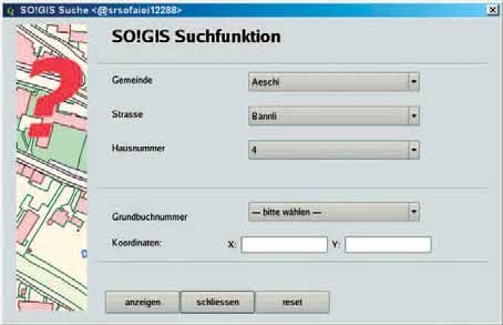
Figure 4.10: “SO!GIS Suche” plugin developed at the Canton
of Solothurn . . . . . . . . . . . . . . . . . . . . . . . . . . . . . . . . 83
iv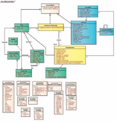
Foreword

    It is our great pleasure to write the foreword for the “FLOSS Cadastre” publica-
tion in our respective functions as Chair of FIG-Commission 7 and as the officer re-
sponsible of FAO’s Land Tenure Group. This booklet has been compiled and edited
by the initiators of this work, Dr. Daniel Steudler (Chair of Working Group 7.3 of
FIG-Commission 7) and Dr. Mika-Petteri Törhönen (Land Tenure Officer, FAO), as
well as by Ms. Gertrude Pieper, who provided technical leadership for the entire
initiative. We want to congratulate all three for this accomplishment and wish to
express our gratitude for this new theme of exploration within our cooperation.
    Land administration and cadastral systems in the 21st Century, which play an
important role in practical implementation of responsible land governance, de-
pend on the use of information technology (IT) tools. The application of these
tools affects very much the systems’ efficiency and costs. While commercial soft-
wares have helped to establish the infrastructures of today and continue to do so,
open-source alternatives, which have achieved considerable significance in many
IT fields, have grown to provide credible alternatives for consideration. For various
reasons, however, they are not often used in land administration and cadastre,
even when their potential is increasingly recognised. This booklet aims to shed
light on this potential, exploring the advantages, and disadvantages of open-
source solutions within the context of cadastre and land registration.
    This booklet is the result of four years of cooperation between FAO and FIG-
Working Group 7.3. This cooperation has allowed the participation and contribu-
tion of a wide variety of authors, who come from different settings of different
world regions. We would like to express our deepest appreciation to all of them
and for their valuable insights into the “theory” and “practice” of open-source
concepts and software, both in general and in the context of the cadastre and
land registration. Finally, many thanks for swisstopo for facilitating the publication
of this work.

                                                                                     v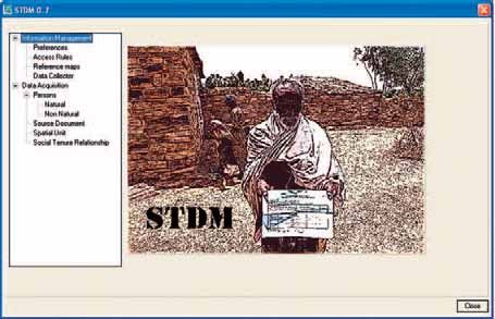
We expect this booklet to be a contribution to further developments in support
of the crucial basic infrastructure of a functioning society, and, through that, to
improvements in social and economical development.

Dr. Paul Munro-Faure                     András Osskó
Principal Officer                         Chairperson Commission 7
Climate, Energy and Tenure Division      Cadastre and Land Management
Department of Natural Resources          International Federation of Surveyors FIG
and Environment
Food and Agriculture Organization
of the United Nations FAO

vi
1.   Introduction

Daniel Steudler, Mika-Petteri Törhönen

Background

   When it comes to computer software, the old saying “you get what you pay
for” may no longer apply. After years of skepticism towards open-source soft-
ware, many of today’s open-source solutions are as good, if not better than pro-
prietary software solutions. The question is – why is it then that there are so few
land administration systems making use of open-source software technology?
Lack of knowledge about the possibilities might be one of the reasons. After all,
marketing has never been a priority for developers of open-source software.
Doubts about the security and available software support could further shy away
cadastre agencies from making the switch.
   Land administration and cadastral systems are playing a crucial macro-eco-
nomic role in the collection, management, and dissemination of information about
land ownership, use and value. Cadastral systems are documenting land tenure
rights and are thus providing crucial economic, social and environmental benefits.
Modern cadastral systems make extensive use of information technology (IT) sup-
ported by software systems. In developed countries, such systems have been es-
tablished over the last 20-30 years and became powerful tools in operating cadas-
tral systems. In developing and transitional countries, the need for efficient cadas-
tral systems and the use of IT is as much a necessity as it is in developed countries,
although there are substantial financial and operational constraints.
   The motivation for FAO, World Bank and FIG to become active in the field of
open-source software for cadastre and land registration comes from the observa-
tion that many systems and projects in developing countries struggle to provide
appropriate and affordable services for tenure security. Reasons are related to gov-
ernance but also to technological and financial shortcomings. Information techno-
logy plays a crucial role in operating cadastres and land registration systems. In
developing countries, the on-going license costs of proprietary software often
created serious constraints and have even stopped programmes.
   The costs of proprietary software licenses have proved to be a constraint, but
even more, the lack of capacity, models and support to develop software have
stopped initiatives. Open-source software, which has become a credible alternat-
ive to proprietary software, provides a way forward. Open-source solutions are
more flexible and adaptable to local conditions and languages than proprietary
                                                                                    1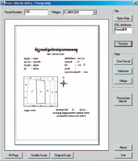
software. By using and improving open-source software, cadastres can build local
knowledge and contribute to the development of open-source projects that can in
turn benefit other cadastres world-wide.

Aim of publication
   The aim of this publication is to explore open-source software in general and
in particular in the fields of cadastre and land registration and to come up with
recommendations and hints for countries that are thinking of using open-source
products. Open-source software has become an issue that cannot be ignored any
longer and that actually might provide solutions to existing problems. This publi-
cation wants to explore and to develop an understanding of open-source software
in as much a balanced and unbiased way as possible, give recommendations and
reflect on lessons learnt with long-term validity on a conceptual and strategic
level.

Structure and content
   The publication is structured in the following five chapters.
   Chapter 2 is providing some background information on the Open-Source con-
cept. The first section gives an insight into the Governance side of Open-Source;
the second section introduces the terminology and basic concept of open-source
software; while the third section presents open-source software for geospatial
data and the establishment of OSGeo, a foundation for open-source software in
the geospatial domain.
   Chapter 3 presents an overview of existing open-source tools and projects for
the management of land information. The first section is looking at the software
needs for cadastre and land administration systems and gives an overview of exist-
ing open-source tools and and possibilities. The second section looks into the
experiences and lessons from an existing platform for open-source development,
the GeoNetwork project. This section provides experiences in how to manage an
open-source project, how user and developers communities are formed and sheds
light on the steps to take for an open-source project in order to become a mature
OSGeo project. The third section describes the OSCAR project, which is to de-
velop operational open-source modules for use in several country case studies. The
2
OSCAR project is commissioned by FAO and carried out by the University of Otago
in Dunedin, New Zealand. The fourth section presents the initiative taken by FAO
to support the building and use of open-source products in the cadastral and land
registration field. The fifth section introduces the “Social Tenure Domain Model”,
a standardized data modelling approach, a crucial aspect for the open-source idea
in the geospatial domain, in particular the cadastral field.
   Chapter 4 then gives the perspectives of six countries or states that already
have adopted or are planning to adopt an open-source policy for their software
application approach. It gives experiences and valuable recommendations for
others.
   Chapter 5 finally draws some conclusions.

                                                                                3
2. Background on Open-Source
and Linkage to Cadastre
2.1 Open-Source Software and Responsible Governance
of Cadastral Systems
Mika-Petteri Törhönen, Rumyana Tontchovska, Gertrude Pieper
Responsible governance of tenure and information technology systems
Access to land, shelter and natural resources and the associated tenure securi-
ty have significant implications for development. Secure access to land and other
natural resources is crucial for hunger and poverty alleviation, and the protection
of the environment. Land and other natural resources provide the platform for
food and shelter, economic production and a basis for social, cultural and religious
practices. Access to land and other natural resources is increasingly affected by
climate change, violent conflicts and natural disasters, population growth and
urbanization, and growing demands for land for agriculture and for new energy
sources such as bioenergy. Security of tenure encourages long term investments
on land and creates incentives for sustainable rural development.
Providing secure access to land and other natural resources is essential for the
achievement of the World Food Summit Plan of Action and the Millennium De-
velopment Goals (MDG).1 Access to land is a direct factor in the alleviation of
hunger and rural poverty (1st MDG). Rural landlessness is often the best predictor
of poverty and hunger: the poorest are usually landless or land-poor. Inadequate
rights of access to land and other natural resources, and insecure tenure of those
rights, often result in extreme poverty and hunger. Women are one of the groups
that often have fewer and weaker rights to land. Through the registration of land
in their own names, women will get better access to credit and agricultural inputs
(2nd MDG). The project contributes indirectly to ensure environmental sustain-
ability (7th MDG). Land tenure, by defining access and security of rights to land and
other natural resources, affects how farmers decide to use the land, and whether
they will invest in land improvements.
Weak governance is a cause of many tenure-related problems, and attempts to
address tenure problems are affected by the quality of governance. Weak govern-
ance hinders economic growth and sustainable use of the environment, condemns
1 FAO-NLRA, see http://www.fao.org/nr/ltenure/lt-home/en/
4people to a life of hunger and poverty, and may result in FLOSS of lives through
violent conflicts. Responsible governance of tenure of land and other natural
resources can help to reduce hunger and poverty and to support social and eco-
nomic development. An effective and transparent land administration has an
important role in ensuring the responsible governance of tenure. Responsibly
governed tenure arrangements promote land use practices that enhance the envi-
ronment. Inevitably in the 21st century IT systems are a critical element of good
land tenure systems.
Grassroots realities
However land administrations commonly fail to secure land tenure rights of the
poor and the vulnerable. Their services are not affordable and their staff incentives
work against serving the needy. Weak governance as well as technical and institu-
tional shortcomings reinforce the failures. The systems are inefficient, poorly struc-
tured and geared for serving a well paying client rather than a poor peasant. Land
administrations’ poor performance results partly from the lack of adapted and
flexible software tools to standardise, structure and maintain the cadastre and the
land registration. As a result, land administration operations remain unfeasible
and only those that yield significant informal incomes survive.
The weak governance of tenure has most severe impact to the livelihoods and
survival of people in developing countries, but it is important to notice that issues
of governance of tenure are not country, region or development level specific,
which for example the Global Corruption Barometer 2009 2 has confirmed, high-
lighting the fact that corruption in land issues is a common-place throughout the
world.
IT Systems improve responsible governance
Since their introduction IT systems have enabled quick improvements in trans-
parency by providing electronic access to records, and in non-discrimination
through standardising services and fee structures for electronic accounts. Intro-
duction of IT systems to land registration is one of the most important steps in re-
ducing opportunities for corrupt and non-transparent land management. Records
and procedures are often standardized and logically structured for the first time
with the introduction of IT systems. On another level innovative technology ap-
plied to land records and graphics improves knowledge based decision making
and widens means for data dissemination and access to land records. Commun-
ities directly benefit from improvements in transparency.
Software has, however, also been a part of the problem in the inefficient man-
agement of land tenure data. In developed countries and countries in transition,
2 http://www.transparency.org/news_room/in_focus/2009/gcb2009
5applying IT tailored around a relational database and geospatial software for land
records and cadastral maps has helped, and often forced, agencies to standardise
their workflows and land records to meet the logic of IT systems. However, IT has
yet to help developing country land agencies much. The costs of proprietary soft-
ware licenses have proved to be a constraint, but even more, the lack of capacity,
and the lack of flexibility of models and the lack of support to develop software
have stopped initiatives. Even when there are existing systems only narrow geo-
graphical coverage is reached. It is safe to say that developing country land admin-
istration IT systems currently do not serve the poorest parts of the community any-
where. It simply is not feasible.
Can open-source software help?
It is considered that the development of affordable and flexible information
management systems in developing countries will provide more secure access to
land and other natural resources in areas where this has not been feasible before
and therefore for poor rural people.
Open-source software (FLOSS) 3, which has become a credible alternative to pro-
prietary software, provides a way forward. Open-source means that, unlike propri-
etary software, developers have access to the software’s “engine”, which can be
freely modified and adjusted. Open-source solutions are more flexible and adapt-
able to local conditions and languages than proprietary software. By using and im-
proving open-source software, cadastres and land registers can build local know-
ledge and contribute to the public development of open-source projects (via for
example web communities) that can in turn benefit other cadastres world-wide.
However, little knowledge and experience is yet available on the introduction of
open-source systems in land registration and cadastral systems. While there are
several examples of FLOSS used successfully in land records (see Chapter 3 of this
booklet), land agencies in developing countries generally lack the IT expertise to
build up a digital land records and mapping systems without external support.
Open-source database and GIS (Geographic Information System) software is read-
ily available, but there is a lack of awareness and lack of leading samples and suc-
cess stories to encourage others to follow. It is clear, however, that the utilisation
of FLOSS solutions for land records is a rapidly increasing trend and that the aware-
ness is spreading rapidly. We don’t need to wait for long for a leading sample to
emerge.
Word of caution
FLOSS bears a promise for easier entry of developing countries to the era of IT
system-managed land administration. However, we should be careful not to over-
3 Often referred to as FLOSS i.e. Free / Libre and Open-Source Software.
6estimate its potential. The idea that IT systems can be installed within a limited
amount of time and then used permanently thereafter is a common misconcep-
tion. Building a digital land administration system, as any other digital administra-
tion system, is a continuous process rather than a one-time event. After installa-
tion, there will be new requirements and additional functions to be added. Hard-
ware and software will need to be upgraded. Maintenance of the system must be
planned and taken into account. System sophistication cannot exceed the avail-
able long term resources and in particular local capacities. System development
relying in external know how should be used only with a credible exit strategy
building local capacities. Although the costs of software maintenance and support
when adopting FLOSS based systems will probably be lower than would be the
case with proprietary software 4, they are not to be underestimated. FLOSS may
make the maintenance easier, as problems can be solved without external support
also making use of international user and developer communities, and cheaper, as
license fees can be reserved for the maintenance and further development of the
system. However, all IT systems require substantial budget and skills for mainten-
ance, and developing country cadastral agencies have traditionally struggled to
establish adequate resources for maintenance. Application of FLOSS will not
change the fact that a proper business plan is the key requirement for introducing
IT systems for land records.
Application of FLOSS to land registration and cadastral systems is likely to suc-
ceed in countries where the government embraces the idea of using open-source
software for their information systems, and support the use of FLOSS in education
and research activities. In such a national context, it will be easier to find local IT
specialists who are familiar with FLOSS products that form the base and ability to
maintain systems beyond their initiation.
2.2 Free and Open-Source Software
Arnulf Christl (President OSGeo)
In most cases the terms “Free Software“ and “Open-Source“ can be used syn-
onymously as in the acronym FOSS. For the sake of clarification this text differen-
tiates between Free Software as a licensing model and Open-Source as a develop-
ment model. To emphasize the aspect of freedom sometimes the word “Libre“ is
included as an L to form the acronym FLOSS.
4 With proprietary software systems, typical maintenance fees account for a third of the software expenses.
Service fees for FLOSS maintenance and support are more transparent and usually on a pay-per-service
basis. See: Are proprietary maintenance fees worse than open-source maintenance fees?
http://news.cnet.com/8301-13505_3-9827846-16.html
7Free software licensing
The word “free“ in Free Software refers to a degree of freedom and should not
be confused with free as in gratis or in free beer. To make things a bit more
complicated most software that comes with a Free Software license is available
completely gratis or at a very marginal cost of a few cents for the actual download
process. But the emphasis stays on the freedom of the user. With a Free Software
license the user is free to:
• use the software anywhere and for any purpose;
• take it apart, understand and improve it;
• pass it on to anybody else in both the original or a modified version;
• make money by using it for any purpose;
• improve it in exchange for a monetary compensation or for any other reason;
• provide all kinds of services around it including training, installation, mainten-
ance, etc.
These levels of freedom make up a Free Software license. For a comprehensive
list of approved Free Software licenses please refer to the Free Software Founda-
tion 5 or the Open-Source Initiative 6.
Proprietary software
The opposite of Free Software is proprietary software. The single but very
central difference between the two types of licenses is that in the latter case the
proprietor (owner) of the software will restrict some or all of the above mentioned
freedoms. You (the licensee) are usually not allowed to use the software in more
instances than is explicitly defined in the license contract. You are usually not
allowed to take the software apart, or to modify it. You are not allowed to give
the software away to anybody else. In some cases you are not allowed to make
money by using the software in a certain way (by giving trainings or providing
maintenance). In other cases you are not allowed to provide services for the soft-
ware without an additional license. Basically, proprietary licenses are designed to
restrict freedom and explicitly take away the rights that are defined by the Free
Software license model. This sounds bad for the user, but it is actually not. It is just
a very accepted, although somewhat different business model and for some time
it has been very efficient in generating revenue and even made one such propri-
etor the richest person in the world. The proprietary software model, however, is
in decline.
5 Free Software Foundation at http://www.gnu.org.
6 Open-Source Initiative at http://www.opensource.org.
8Open-source development model
In most cases “Open-Source“ can be used synonymously for “Free Software“.
For the sake of this introduction we will look at Open-Source from a development
model perspective. The source code of software contains all the functionality in a
human readable format. To change, enhance or extend the functionality of most
software it is required that the source code be modified. Thus Open-Source is a pre-
condition for Free Software. End users will generally have no need to look into the
source code and only work with the compiled, machine readable version. But it is
still important to have the right to look into the software, because only then we can
fully understand what it is doing. Even if we do not, we can still pass it on to some-
one else who does have the capacity needed to understand the code. This will give
the user a degree of freedom from the monopoly of the vendor that proprietary
licenses deny. All scientific research is based on absolutely transparent reproduci-
bility which is not given if there is no possibility to look into the sources. Thus,
strictly speaking, proprietary software cannot be used to analyze data for valid sci-
entific research. Software developers naturally tend to drift to open development
models because it makes reusing code a lot easier and allows for collaboration
across organizational boundaries and between otherwise competing businesses.
For many people these rather basic facts are completely new concepts, because
they are not transparently communicated together with proprietary software.
Product and development cycle
The motivation to create and maintain open-source software is inherently dif-
ferent to that of a product vendor (see Figure 2.1). The left side of the illustration
shows the typical development process of a vendor. The motivation of the vendor
model is focused on making a profit. This will usually include a market study prior
to starting the development. The development process itself is iterated in a closed
environment until the software is released. The release date in most cases does not
coincide with the software being ready to ship but with an event, for example a
major industry trade show.
On the right side (Open-Source) the intrinsic motivation is often to solve a prob-
lem at hand. If the problem is common then the resulting solution can be of use
to others and over time a number of regular users (participants) may emerge. In
this case the software is said to “take off“ and it starts to get published on the
web on a regular basis. New requirements appear as more users use the software
in different contexts. The requirements may then be implemented in the order of
need or availability of funding. If the project is successful, development will stabi-
lize either through a growing user community or through one or more businesses
that profit from continuing development on the software. The diagram shows
some aspects of these differences.
9Proprietary motivation: Make Money Open Source motivation: Solve Problem
Market analysis Problem is identified
Development team
Software development team
develops software
solves problem
beta version release
for beta tester Publish Code
beta tester reports errors to
development team Internet as communication
pool and distribution media
development team
reproduces the error
Participators find errors and
development team reports to solve the problem
the product management
Improved code is
development team solves published in the Internet
problem after OK from pm
new version is released
Product is launched
Figure 2.1: Proprietary and open-source development models (Christl, 2008).
Most noticeably the proprietary, closed development process limits the quality
assurance to a restricted set of individuals. In the open development model every-
thing is open to the scrutiny of many, which can result in the highest level of
stability and security.
The obvious advantages of the open-source development can be seen in the
emergence and success of major projects like the Apache HTTP server (now
running more than half of all websites globally). More specifically in the geospatial
realm this effect can be seen in software packages like GDAL / OGR, PostGIS, Proj4,
MapServer, GeoTools and many more.
The open development model has that many advantages that all major propri-
etary vendors nowadays also naturally use the quick feedback mechanisms by ask-
ing users to fill out crash reports. Results from these reports may then be distrib-
uted as patches through web technology, which is exactly the way open-source
software development environments are applying for many years. The difference
here is again less transparency. While in an open-source software project all cur-
rent open and closed issues can be seen and analyzed and reacted to, proprietary
vendors will usually keep them locked away.
Open-source and security
At first sight being “Open“ seems to contradict security, because in the physi-
cal world we are used to locking things away to prevent them from being stolen.
Thus proprietary code – that is itself essentially locked away – would also appear
10be more secure because none can look into its inner workings. But one of the very
first paradigms of digital security says that security cannot be achieved by obscur-
ity. Instead, all algorithms, architectures and concepts required to secure things
must be open to the scrutiny of as many eyes as possible. This will ensure that they
will get tested and verified by as many experts and in as many different settings as
possible. Additionally it would not make any sense at all to try to lock away all
protocols, code, software and architectures as “secret“ because then no one can
actually use and implement them. The only way out of this deadlock is to improve
the software and architectures to the point that it becomes very hard to break.
This is exactly how security in the digital world works. All the encryption protocols
that form the core security layer of the Internet are based on open-source models.
Real security has to stand up against being completely and thoroughly transpar-
ent. Only by opening up all processes to the scrutiny of as many participants as
possible, a reliable security system can be built.
Proprietary black box security systems might be hard to break to start with. But
up to now in history every single security system ever has sooner or later been bro-
ken. Therefore the most important issue of digital security is to know when it has
been compromised so that counter measures can be taken. For that reason all ma-
jor security systems that are in common use nowadays are based on open-source
models. This does not mean that proprietary software can by definition not be
secure because it can implement the same open-source algorithms, which is
exactly what happens.
One example for geospatial open-source adoption in a high security domain is
the US Department of Defense (DoD). It was one of the major initial supporters of
geospatial Open-Source including the initial development of GRASS (the Geo-
graphic Resource and Analysis Support System). With the uptake of proprietary
software in the 80s and 90s and the general need to reduce costs, new business
models emerged and the DoD turned to so called CotS (Commercial off the Shelf)
software. The hope was to be able to reduce the TCO (total cost of ownership)
by not developing software in-house but to rely on external sources. Recent
studies conducted by the DoD evaluated the results of this strategy and show that
the open-source model is not inferior to the proprietary model from a financial
perspective and that it is definitely superior with respect to security. As a result the
DoD is shifting its focus again and has changed its documents accordingly (DoD,
2009) to allow the use of open-source in tenders, stating that open-source and
proprietary software can synonymously be called “commercial software“.
FLOSS business models
Usually FLOSS business models are explained by listing activities that can be of-
fered as a service. But it is a lot easier to work from the other end and acknow-
11ledge that all business models around software naturally apply to FLOSS except
for exclusive proprietary licensing. Estimates show that less than 5 % of all rev-
enue generated by business activities around software is generated by selling
proprietary software licenses (Perens, 2005). On the other hand there are practic-
ally no reliable numbers that could quantify the positive net productivity effect of
any given software as it is not possible to compare one over another in a repro-
ducible environment.
One reason why open-source models have been adopted early in the geospatial
domain is the intrinsic interconnectedness of spatial data which relates well to the
interconnectedness of knowledge – and code is nothing but formalized know-
ledge. Especially in the geospatial domain, a healthy business environment has
emerged as can be seen in the Service Provider Directory of OSGeo, where a total
of more than 150 companies are registered. This register represents only a fraction
of all businesses that offer service, support, training, consultancy and mainten-
ance for the whole range of spatially enabled software, ranging from the single
contractor business to divisions of large enterprises that employ several hundred
specialists.
FLOSS adoption by the industry
Unquestionably open-source is the superior development model. This has been
proven by all major software enterprises, one of its pioneers being IBM which
recognized the emerging paradigm shift at a very early stage. Nowadays all major
software vendors including Oracle and even Microsoft have at one point either
purchased open-source companies or product names or adopted the associated
development methods. More specifically in the geospatial realm, open-source
components are plainly used by proprietary vendors to support their own products
– but only if it does not conflict with their core business interests of selling soft-
ware usage licenses. Two recent examples are the company Oracle which uses the
GNU Linux operating system to run their software, but not PostGIS to power their
spatial database. ESRI on the other hand supports PostgreSQL (to avoid costly
Oracle licenses for their customers), but not PostGIS because this would conflict
with their own software product SDE. The intricacy of commercial acquisitions and
their long term effects are hard to predict as can currently be seen with MySQL AB
being bought by Sun Microsystems, which itself is coming under the control of
Oracle. This illustrates that it is financially and strategically prudent not to rely on
one vendor or product, but to use Open-Source and to diversify.
The proprietary conflict
FLOSS and proprietary software go well together, especially if they adhere to
standards. We have to acknowledge, however, that the business model associated
12with proprietary software does not go together well with Open-Source. Some-
times the discussion on the pros and cons are fought out as if it were a religious
war. On closer inspection the problems at hand are quite transparent and result
from the deprecation of the proprietary business model which is desperately trying
to compete with evolution. As we have seen the core reasons for the uptake of
FLOSS are neither religious nor altruistic but simply inherent to good software de-
velopment. The reason for the intermittent success of proprietary models was the
absence of a ubiquitous network of communication that worked at marginal cost
– the Internet. Now that we have it and know how to use it the exclusive nature
of proprietary software business models has a problem.
With proprietary software, customers need to pay in advance and decide peri-
odically whether to extend the maintenance contract for the upcoming contract
period. With Open-Source this is different. It can be run any time at no additional
cost and without long-term contract commitment. If it does not work it can be
exchanged – obviously with some cost but a lot less than what proprietary market-
ing wants to make us believe for so many years. This brings us to the most obvi-
ous problem in the proprietary / FLOSS struggle: Marketing. Proprietary has too
much of it and FLOSS too little. Over time a lot of Fear Uncertainty and Doubt
(FUD) has been spread to the detriment of open-source software. This has under-
standably caused a backlash of wild arguments against proprietary software from
a marketing-unaware group of geeks. But these have organized themselves over
the past years and done good work in removing most FUD so that Open-Source is
now socially, technologically and financially acceptable.
FLOSS will make life a lot harder for monopolists who cannot innovate as easily
as an open community of thoroughly networked developers on the loose. Espe-
cially monopolists are well advised to carefully adjust their business models to this
new challenge. On the good side of business FLOSS is an enabler for innovation
and a door opener for start-ups and small and medium enterprises. These will also
make sure that business will be more local making it more efficient and more
attractive for public administrations and governments as it strengthens the local
economy.
Conclusions
It can safely be said that Free and Open-Source Software is here to stay. Change
in large organizations has a high latency, therefore proprietary business models
will be around for many years to come. Companies who employ hundreds of sales
people cannot change their business model in a day. The same applies to organ-
izations like cadastral base map agencies who operate very large and complex sets
of data with high Vendor-Lock-In potential. On the other hand spatial IT also has
a long tradition of using and adhering to standards because spatial data is by
13definition boundless and needs to interoperate. The convergence of standards and
Open-Source will be the core element for all future solutions.
References
Christl, A. (2008). “Free software and open-source business models”, in Hall, G. Brent and Michael G. Leahy,
(eds.) Open-source approaches to spatial data handling, Springer, Berlin, 21– 48.
DoD (2009). Clarifying Guidance Regarding Open Source Software (OSS). http:cio-nii.defense.gov/sites/
oss/2009OSS.pdf or http://wiki.osgeo.org/wiki/Case_Studies#US_Department_of_Defense, last accessed
on 14 Jan. 2010.
Hall, G. B. and M. G. Leahy (2008). Open-source approaches to spatial data handling, Springer, Berlin.
Perens, B. (2005). The Emerging Economic Paradigm of Open Source. http://perens.com/Articles/Economic.
html, last accessed on 14 Jan. 2010.
2.3. Open-Source Software for Geospatial Data –
The Birth of OSGeo
Arnulf Christl
Introduction
Free and Open-Source Software experienced a strong uptake in the early days
of the Internet, most notably through the GNU Linux operating system and Apache
web server. But beyond these well known projects, Open-Source is still a new
concept for many people. Interestingly, Open-Source has a long history of leader-
ship especially in spatial software development. In the late 1970s development of
the Map Overlay and Statistical System software (MOSS 7) started after researching
into existing code that was available as public domain. In the 1980s development
of the Geographic Resource Analysis Support System (GRASS 8) started, a project
implemented mainly in C that over many years grew to over half a million lines of
code.
With the rise of proprietary software the tendency for Vendor-Lock-In increased
dramatically because vendors implemented closed formats. Therefore in the early
1990s the need for openness shifted away from developing software to making
data formats interoperate more easily. To support this effort the GRASS commun-
ity changed its focus and founded the Open Geospatial Foundation (OGF). Devel-
opment of the GRASS software diminished and eventually subsided. But the
emerging structures of the Internet allowed the project code to stay available,
even although in a dormant state. In 1994 the OGF was transformed into the
Open GIS Consortium (OGC 9) later renamed to Open Geospatial Consortium to
address the needs for standards by a growing global industry. Nowadays the OGC
7 http://www.scribd.com/doc/4606038/2004-Article-by-Carl-Reed-MOSS-A-Historical-perspective
8 http://grass.osgeo.org/
9 http://opengeospatial.org/
14is the principal consortium for open standards in the geospatial world and works
on ISO standards with geospatial relevance through a class A liaison with the
Technical Committee 211 (ISO TC 211).
With the emergence of the Web as ubiquitous communication network on the
Internet in the second half of the 1990s GRASS was reawakened by academia
under the lead of Markus Neteler. GRASS development picked up speed again and
started to grow into a highly committed community which recently celebrated the
25 year anniversary of GRASS.
At the same time the first versions of the MapServer 10 software emerged in the
ForNet project. It was funded by NASA in 1996 and was initially developed by
Steve Lime, a single developer who included the work on shapelib 11, implemented
by another early contributor, Frank Warmerdam. It soon became apparent that this
new type of web based software addressed the needs of a growing community of
GIS users who recognized the potential of the Web (much later they would be
known as Neo-Geographers).
In another parallel effort OGC members created the Web Map Server standard
(OGC WMS) towards the end of the 1990s. Nowadays this is the standard open in-
terface to an immense diversity of map services world wide. With the emergence
of the Web 2.0 and a growing sense of belonging of the hitherto disconnected
developer communities of GRASS, MapServer and several other projects, the need
for a common organization was articulated. OGC was not suitable to develop or
maintain software, because its structures had solidified around open standards
and additionally the needs of mostly proprietary vendors who then would have
become direct competitors. During this time, active users and developers of the
geospatial open-source community started discussions, which eventually lead to
the founding of the “Open-Source Geospatial Foundation” as is described below
in more detail.
The challenges of Open-Source
Diversity and high turnover are essential to the success of Open-Source. At the
same time they are the root for two major challenges:
• Anyone can publish anything under an open-source license. There is no inher-
ent quality control in Open-Source.
• There is no single, compelling reason for continuity in an open-source project.
Both challenges also have to be addressed by proprietary software because they
are not integral components of the proprietary business model. But the propriet-
ary business model relies entirely on trust and reputation. Therefore brand quality
10 http://mapserver.org/
11 http://shapelib.maptools.org/
15is one of the most important assets for a proprietary software vendor. The second
is continuity which is the only leverage to maximize the return on investment. So
even although the motivation of proprietary businesses to address these chal-
lenges is not based on the customer’s needs at least they get addressed. Open-
Source in itself can be based on an intrinsic motivation that will take care of
both continuity and quality but it is very hard to evaluate from the outside of a
project.
The web based development platform SourceForge.net 12 hosts 230,000 open-
source software projects (February 2009). The requirements to be accepted into
SourceForge are that the code has to be published under a commonly accepted
open-source license and that some code is published through the SourceForge
code repositories. There is no other quality assurance. The SourceForge code re-
positoriy is just one web based development platform, there are an additional
unknown number of projects that are simply “released“ under the open-source
label, sometimes with legally dubious licenses or without specifying any licenses
explicitly at all.
This demonstrates the importance of looking at code quality, project govern-
ance and license model separately prior to relying on any open-source software.
Just because software is published under an open-source license does not
automatically mean that it is good software. Anybody can publish anything and
postulate that it is the best around. In many open-source projects there is no
responsible legal entity to the project beyond the individual contributor.
Especially large organizations sometimes require that products which become
structural core components of their IT infrastructure are backed by a reliable legal
entity. Many small open-source projects lack this legal background which excludes
them from being used in these organizations.
Organizations supporting Open-Source
There are three distinct types of organizations that support Open-Source for
different reasons. The first two are commercial for-profit businesses and the pub-
lic administration. The third type consists of community driven non-profit organi-
zations whose mission is to further and promote Open-Source in distinct domains.
Commercial businesses and public administrations scale – meaning that there
are many instances that use and also support all kinds of Open-Source. They have
both specific interests but also inherent limitations to open-source projects as we
will see below. These limitations can be compensated for by non-profit organiza-
tions.
Free and Open-Source Software is widely used by companies delivering com-
mercial services as can be seen in the service provider director of OSGeo where
12 http://sourceforge.net/
16product support, maintenance and training services are listed 13. The Free Software
license model does not conflict with their business interest; instead it is a comfort-
able means to enhance revenue by delivering solutions that do not incur external
fees. In some projects it can even facilitate cooperation between competitors who
collaborate on non-differentiating software. It is in the interest of these businesses
to keep the open-source projects alive by supporting them through sponsorship or
in-kind contribution and collaboration on development.
But the support will mostly be limited to the area where it is directly profitable
to the business and also vary according to the overall financial situation of the
company. In a difficult financial situation this type of sponsorship is top on the cut
back. Widespread commercial use of Open-Source and the corresponding support
will only start when the software has reached a mature state. There is little or no
incentive in supporting open-source projects in their infancy.
Public administrations can develop a specific interest in supporting Open-
Source because it can prevent Vendor-Lock-In situations. Larger governmental
institutions have in the past often maintained development teams and imple-
mented software on their own. Since the 1990s internal development budgets
have been cut back considerably to reduce costs in the hope that “Commercial off
the Shelf“ (CotS) software would fill the gap. In parts this has worked out but in
the long run created a much higher dependency, also because business mergers
and acquisitions have led to monopolistic structures.
Currently a growing understanding of the inherent advantages of Open-Source
especially for the public administration has fueled a renaissance of Open-Source
support. But the years of neglecting internal capacity building can be seen, they
must be compensated in order to be able to profit from all the advantages of
Open-Source. Additionally the working conditions should be enhanced to be able
to recruit a (young and) creative workforce. Budget cuts should not simply be
accepted, there are many good reasons to create, maintain and provide access to
spatial data in public administrations. These reasons should be laid out clearly to
policy decision makers. Especially geospatial experts have the expertise to actually
collect and convey these reasons.
Just like commercial entities the public administration has little interest in sup-
port fledgling projects that have a high risk of not succeeding. Public procurement
processes have been modified in the late 80s and 90s of the last century to better
address the needs of proprietary businesses, now they are not well prepared to
support Open-Source. Some change is already taking place, even at highest levels
as can be seen in the Department of Defense of the United States of America 14 or
the European Union with the Open-Source Observatory Repository (OSOR 15). But
13 http://www.osgeo.org/service_provider_directory
14 http://wiki.osgeo.org/wiki/Case_Studies#US_Department_of_Defense
15 http://www.osor.eu
17it is a long and slow process that also has to deal with the fears and resulting
resistance of deprecating but still strong proprietary business interests.
For all of these reasons community-driven non-profit organizations have emer-
ged in all major IT sectors to cater for the needs of open-source projects that
cannot be addressed by commercial businesses or public administration.
Community-driven non-profit organizations
The best organizational structure to address the challenges of Open-Source are
community-driven non-profit organizations. They can ensure that open-source
projects prosper and develop in the most effective way. They can protect them
from potentially harmful proprietary interests and give them a long term technical
and legal framework. They can be home for a creative and vibrant community
which will maintain and further a diverse ecology of quality open-source software.
They are also a framework for the orientation of potential users who can later turn
into a new type of investor. These are not capital investors with a single interest of
maximizing return on investment but with an interest of adding functionality,
quality and longevity to software that helps to solve their day to day problems.
One of the earliest professional open-source software packages that were
broadly deployed was the Apache http server. It caught the interest of IBM who
had come to the conclusion that the open-source software was superior to what
they were developing. This spawned the need for a legal organization for the de-
veloper community that had formed around this software and eventually gave
birth to the Apache Foundation. The Open-Source Geospatial Foundation was
born in a similar way.
In 2005 the hitherto thoroughly proprietary company Autodesk made an un-
expected move by releasing their re-engineered Autodesk mapping software
MapGuide as open-source under the GNU LGPL license. The launch was support-
ed by the developers around the MapServer project who shared a common inter-
est in building a non-profit organization for the geospatial domain. It soon became
apparent that other open-source geospatial software communities (for example
from the GRASS project) recognized the need for an overarching non-profit organ-
ization to help stabilize development, organize conferences, create a legal back-
ground and control the governance of projects – especially because the demand
for open-source software was growing. The result was the formation of OSGeo.
The “Open-Source Geospatial Foundation”
In February 2006 the “Open-Source Geospatial Foundation” 16 – in short
OSGeo – was founded by leading individuals from geospatial open-source soft-
16 http://www.osgeo.org/
18ware projects. OSGeo has developed into the leading voice for Open-Source in the
geospatial domain. It is broadly inclusive because it is not driven by a single busi-
ness with exclusive commercial interests but by a broad and diverse community of
users, businesses, scientists and universities. OSGeo is home for projects imple-
mented in different programing languages, for different user audiences and a
variety of interests as such it is a community of communities.
The mission and tasks of OSGeo
The mission of OSGeo is to create and maintain a diverse ecology of highest
quality open-source software for the geospatial domain. The goals are to provide
a stable environment for collaborative software development, a freely accessible
curriculum and to promote free access to spatial data.
To achieve these goals OSGeo provides resources for existing open-source com-
munities and new software projects including the technical infrastructure, legal
advice and financial backing. OSGeo supports FOSS4G (the acronym for Free and
Open-Source Software for Geospatial) on a global scale and to this end also
organizes outreach and promotion. The main task in this area is to build local
capacities for conferences, promote OSGeo at trade fairs and to facilitate inter-
project communication. OSGeo members work on a comprehensive curriculum to
help educate domain experts instead of “brand-specialists“.
All these activities combine to build a solid market for business which can then
in turn solidify the financial basis needed to perform these tasks. This creates a
chicken and egg situation which in the first years could only be overcome with the
help of many volunteers spending uncountable hours of work in their spare time.
The formal structure of OSGeo
The structure of OSGeo has been gleaned from the Apache model and adopted
to cater for the special character of binding existing communities that have already
evolved in the geospatial domain. OSGeo is based on volunteer work and funded
through sponsorship.
As a legal entity OSGeo needs some formal structure (compare Figure 2.2). In a
nutshell, OSGeo is owned by 94 elected charter members who are extended by 20
members each year. The charter members nominate and elect 9 directors who
appoint the president. The board also appoints the Executive Director who takes
care of formalities like handling finances, signing contracts in the name of OSGeo
and communicating with sponsors.
The board approves the budget and helps to acquire funds, for example by in-
viting sponsors (who act as investors) and by promoting the FOSS4G conference,
which has in the past been one of the major sources of income for the organiza-
tion. Formal committees are created to address different topics; each of them has
19You can also read