Assessing Potential Groundwater-Level Declines from Future Withdrawals in the Hualapai Valley, Northwestern Arizona

 
CONTINUE READING
Assessing Potential Groundwater-Level Declines from Future Withdrawals in the Hualapai Valley, Northwestern Arizona
Prepared in cooperation with Mohave County and the City of Kingman

Assessing Potential Groundwater-Level Declines from Future
Withdrawals in the Hualapai Valley, Northwestern Arizona
2013                                           2020

Scientific Investigations Report 2021–5077

U.S. Department of the Interior
U.S. Geological Survey
Assessing Potential Groundwater-Level Declines from Future Withdrawals in the Hualapai Valley, Northwestern Arizona
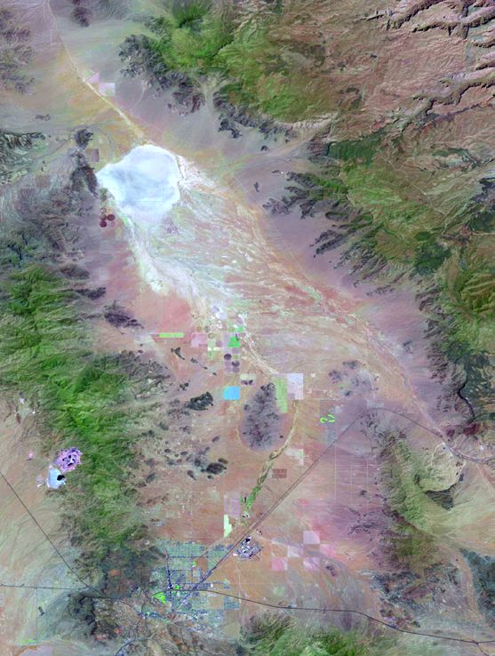
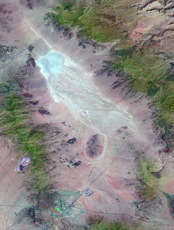
Cover. Satellite images showing land cover change between May of 2013 (left) and May of 2020 (right).
Images are from LandLook Viewer, U.S. Geological Survey. Images are “Natuaral Color” using bands 6,
5, and 4 of the Landsat Operational Land Imager. Backdrop photograph shows an irrigation structure in
Hualapai Valley. U.S. Geological Survey photograph taken on February 20, 2018, from Stockton Hill Road
looking east across Hualapai Valley.
Assessing Potential Groundwater-Level Declines from Future Withdrawals in the Hualapai Valley, Northwestern Arizona
Assessing Potential Groundwater-Level Declines from Future
Withdrawals in the Hualapai Valley, Northwestern Arizona

By Jacob E. Knight, Bruce Gungle, and Jeffrey R. Kennedy

Prepared in cooperation with Mohave County and the City of Kingman

Scientific Investigations Report 2021–5077

U.S. Department of the Interior
U.S. Geological Survey
Assessing Potential Groundwater-Level Declines from Future Withdrawals in the Hualapai Valley, Northwestern Arizona
U.S. Geological Survey, Reston, Virginia: 2021

For more information on the USGS—the Federal source for science about the Earth, its natural and living
resources, natural hazards, and the environment—visit https://www.usgs.gov or call 1–888–ASK–USGS
(1–888–275–8747).
For an overview of USGS information products, including maps, imagery, and publications,
visit https://store.usgs.gov.

Any use of trade, firm, or product names is for descriptive purposes only and does not imply endorsement by the
U.S. Government.

Although this information product, for the most part, is in the public domain, it also may contain copyrighted materials
as noted in the text. Permission to reproduce copyrighted items must be secured from the copyright owner.

Suggested citation:
Knight, J.E., Gungle, B., and Kennedy, J.R., 2021, Assessing potential groundwater-level declines from future
withdrawals in the Hualapai Valley, northwestern Arizona: U.S. Geological Survey Scientific Investigations Report,
63 p., https://doi.org/10.3133/sir20215077.

Associated data for this publication.
Knight, J.E., 2021, Data release for transient groundwater model of the Hualapai Valley Groundwater Basin, Mohave
County, Arizona: U.S. Geological Survey data release, https://doi.org/10.5066/P9017DI9.

ISSN 2328-0328 (online)
Assessing Potential Groundwater-Level Declines from Future Withdrawals in the Hualapai Valley, Northwestern Arizona
iii

Contents
Abstract............................................................................................................................................................1
Introduction.....................................................................................................................................................1
     Purpose and Scope...............................................................................................................................3
     Literature Review...................................................................................................................................3
     Description of Study Area....................................................................................................................3
     Climate.....................................................................................................................................................3
     Conceptual Model of the Groundwater-Flow System.....................................................................5
     Hydrogeologic Framework...................................................................................................................5
     Groundwater-Flow System...................................................................................................................9
     Groundwater Observations..................................................................................................................9
     Groundwater Budget...........................................................................................................................12
           Predevelopment..........................................................................................................................12
           Postdevelopment........................................................................................................................14
     Previous Models..................................................................................................................................14
Simulation of Groundwater Flow................................................................................................................16
     Spatial and Temporal Discretization.................................................................................................16
     Boundary Conditions and System Stresses....................................................................................17
     Hualapai Valley Basin Withdrawal and Recharge Scenarios......................................................22
     Model Parameter Estimation and Uncertainty Quantification........................................................26
           Prior Parameter Distribution.....................................................................................................26
           Parameter Estimation with PESTPP-IES.................................................................................27
           Posterior Parameter Distribution.............................................................................................29
     Simulation of Transient Conditions...................................................................................................29
     Simulation of Future Withdrawal and Enhanced Recharge Scenarios......................................31
Model Limitations and Assumptions.........................................................................................................35
Summary and Conclusions..........................................................................................................................36
References Cited..........................................................................................................................................37
Appendix 1. Simulated Groundwater Levels 1935–2080.........................................................................41
Appendix 2. Parameter Estimation and Uncertainty Analysis of HVHM with PESTPP-IES..............58
Appendix 3. Summary of Groundwater-Level Observation Sites..........................................................60
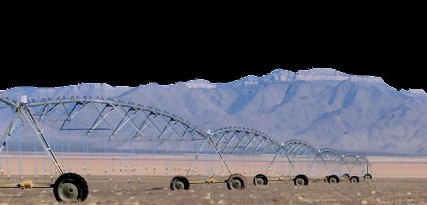
Assessing Potential Groundwater-Level Declines from Future Withdrawals in the Hualapai Valley, Northwestern Arizona
iv

     Figures
         1.   Map showing the Hualapai Valley Hydrologic Model study area and surrounding region........ 2
         2.   Map showing the annual precipitation 30-year normal, in inches per year................................... 4
         3.   Map showing surface geology and fault locations of the Hualapai Valley..................................... 6
         4.   Maps showing subsurface basin geometry models and lithologies of the Kingman and
              Hualapai subbasins........................................................................................................................................ 7
         5.   Map showing generalized groundwater-flow directions based on groundwater-levels
              from select well locations........................................................................................................................ 10
         6.   Graphs showing observed depth to groundwater levels, in feet, at select wells in the
              basin fill of the Hualapai Valley Basin aquifer................................................................................... 11
         7.   Map showing repeat microgravity monitoring locations and gravity change from 2009 to
              2019, in the Hualapai Valley Basin, Mohave County, Arizona........................................................... 13
         8.   Map showing the Hualapai Valley Hydrologic Model grid and material property zones.......... 16
         9.   Cross section of line A-A’-A’’ from figure 8............................................................................................. 17
        10.   Model showing mean annual simulated recharge applied to each model cell, in meters
              per day..................................................................................................................................................18
        11.   Graph showing the simulated annual mean natural recharge for Kingman and Hualapai
              subbasins and the total annual mean natural recharge for both subbasins, in acre-feet
              per year........................................................................................................................................................... 18
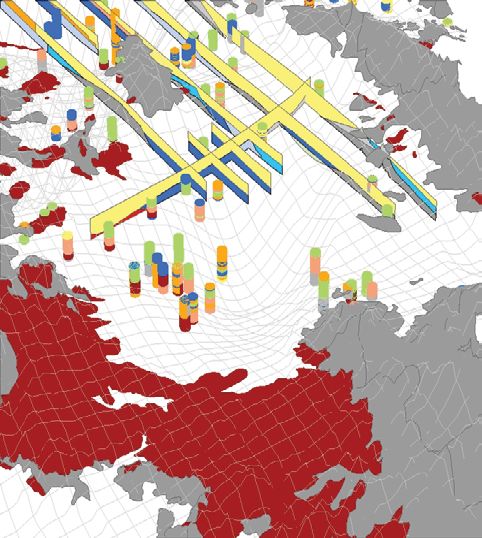
        12.   Map of southeast Hualapai Valley Basin Model cells simulating inflows from Truxton
              Wash................................................................................................................................................................ 19
        13.   Satellite image of and conceptual cross-sectional view across the north boundary of
              Hualapai Valley Hydrologic Model along Hualapai Wash to Lake Mead...................................... 20
        14.   Map of Hualapai Valley Hydrologic Model area showing simulated municipal pumping
              locations and graph showing total withdrawal rates of municipal pumping............................... 20
        15.   Map of Hualapai Valley Hydrologic Model area showing simulated self-supplied domestic
              (SSD) locations and graph showing total withdrawal rates of SSD pumping.............................. 21
        16.   Map showing model cells simulating agricultural withdrawals beginning in 2019, 2024,
              and 2029.......................................................................................................................................................... 22
        17.   Map of model and land-ownership groups and graph showing expected annual
              withdrawals by each group, in acre-feet per year.......................................................................... 23
        18.   Map of simulated locations and graph showing total rates of incidental recharge from
              septic fields and leaky infrastructure, in acre-feet per year........................................................ 24
        19.   Map of southern part of the Hualapai Valley Hydrologic Model showing existing and
              planned enhanced infiltration project locations in the Kingman subbasin............................. 25
        20.   Map showing site locations of observed groundwater levels and drawdowns used for
              parameter estimation of the Hualapai Valley Hydrologic Model..................................................... 28
        21.   Graphs showing objective function reduction over 8 iterations and the posterior ensemble
              distribution of objective function values................................................................................................. 28
Assessing Potential Groundwater-Level Declines from Future Withdrawals in the Hualapai Valley, Northwestern Arizona
v

   22. Two posterior ensemble model realizations of hydraulic conductivity, specific yield, and
       specific storage showing similar fit to historical observation data................................................. 30
   23. Map views showing mean simulated drawdown for the final withdrawal scenario,
       standard deviation of drawdown, and uncertainty reduction of drawdown forecasts....... 31
   24. Graph showing net specified and ensemble simulated model outflows through the
       MODFLOW WEL package.......................................................................................................................... 32
   25. Map views of model area showing specified WEL package fluxes simulated in year
       2079 and amount of specified fluxes not simulated owing to desaturation of model
       cells in year 2079......................................................................................................................................... 32
   26. Graph showing simulated hydraulic heads at site 9, surface elevation of 3,306 feet................. 33
   27. Graph showing simulated hydraulic heads at site 7, surface elevation of 3,152 feet................. 34
   28. Graph showing simulated heads at site 2, surface elevation of 2,945 feet.................................... 34
   29. Graph showing simulated mean depth to water, in feet, in Kingman subbasin........................... 35

Appendix Figures
  1.1.      Graphs of observed and simulated groundwater levels at select wells............................41
  3.1.      One-to-one plots comparing observed to simulated values, and observed to simulated
            residual values, organized by observation type.........................................................................62

Tables
    1.      Predevelopment groundwater-budget values for the Hualapai Valley Basin, Mohave
            County, Arizona, from Garner and Truini (2011)......................................................................14
    2.      Groundwater-budget values for the Hualapai Valley Basin, Mohave County, Arizona.......15
    3.      Municipal groundwater pumping in the Hualapai Valley Basin for years 2010–2017......21
    4.      Agricultural groundwater pumpers and projected annual withdrawals (in acre-feet).......22
    5.      Estimated recharge capacity of existing and planned infiltration projects.......................24
    6.      Aquifer property characteristics, mean prior parameter multiplier range, and absolute
            value range....................................................................................................................................27
    7.      Aquifer property characteristics from base realizations of prior and posterior
            parameter distributions..............................................................................................................29

Appendix Tables

  1.1. Summary of forecasted groundwater hydraulic heads in years 2050 and 2080 at select
       locations, all units in feet.............................................................................................................56
  3.1. Summary of groundwater level and groundwater-level change observations used for
       determining the likelihood of parameter distributions through history matching................60
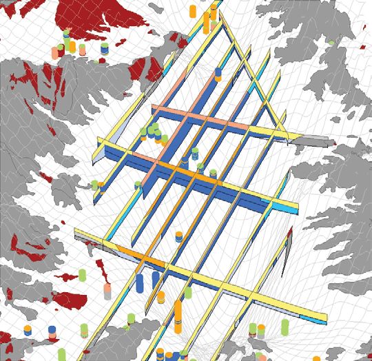
Assessing Potential Groundwater-Level Declines from Future Withdrawals in the Hualapai Valley, Northwestern Arizona
vi

     Conversion Factors
     U.S. customary units to International System of Units

                             Multiply                           By                             To obtain
                                                              Length
      inch (in.)                                               2.54          centimeter (cm)
      foot (ft)                                                0.3048        meter (m)
      mile (mi)                                                1.609         kilometer (km)
                                                               Area
      acre                                               4,047               square meter (m2)
      square mile (mi )  2
                                                               2.590         square kilometer (km2)
                                                             Volume
      cubic foot (ft3)                                         0.02832       cubic meter (m3)
      acre-foot (acre-ft)                                1,233               cubic meter (m3)
                                                             Flow rate
      acre-foot per day (acre-ft/d)                            0.01427       cubic meter per second (m3/s)
      acre-foot per year (acre-ft/yr)                    1,233               cubic meter per year (m3/yr)
      foot per day (ft/d)                                      0.3048        meter per day (m/d)
      foot per year (ft/yr)                                    0.3048        meter per year (m/yr)
                                                   Hydraulic conductivity
      foot per day (ft/d)                                      0.3048        meter per day (m/d)
                                                     Hydraulic gradient
      foot per mile (ft/mi)                                    0.1894        meter per kilometer (m/km)
                                                        Transmissivity
      foot squared per day (ft2/d)                             0.09290       meter squared per day (m2/d)

     Temperature in degrees Celsius (°C) may be converted to degrees Fahrenheit (°F) as follows:
                                                    °F = (1.8 × °C) + 32.
     Temperature in degrees Fahrenheit (°F) may be converted to degrees Celsius (°C) as follows:
                                                     °C = (°F – 32) / 1.8.

     Datum
     Vertical coordinate information is referenced to the North American Vertical Datum of 1988
     (NAVD 88).
     Horizontal coordinate information is referenced to the North American Datum of 1983 (NAD 83).
     Elevation, as used in this report, refers to distance above the vertical datum.
     Depth reported as below the land surface are measured from the land-surface datum, a plane
     that is approximately at land surface at each well where measured.
Assessing Potential Groundwater-Level Declines from Future Withdrawals in the Hualapai Valley, Northwestern Arizona
vii

Abbreviations
ADWR			      Arizona Department of Water Resources
BAS6 		      basic
bls			       below land surface
DIS   			    discretization
DRN 		       drain
GLM			       Gauss-Levenburg-Marquardt
GWSI			      Groundwater Site Inventory
HVHM			      Hualapai Valley Hydrologic Model
INA			       irrigation nonexpansion area
Ma			        million years ago
NAD 83		     North American Datum of 1983
NAVD 88		    North American Vertical Datum of 1988
NGVD 29		    National Geodetic Vertical Datum of 1929
PESTPP-IES   Parameter Estimation and Uncertainty Quantification Iterative Ensemble
			           Smoother software
ppm			       parts per million
RCH 			      recharge
SWB			       Soil-Water Balance
UPW 		       upstream weighting
USGS			      U.S. Geological Survey
WEL 			      well
Assessing Potential Groundwater-Level Declines from Future Withdrawals in the Hualapai Valley, Northwestern Arizona
viii
Assessing Potential Groundwater-Level Declines from Future
Withdrawals in the Hualapai Valley, Northwestern Arizona
By Jacob E. Knight, Bruce Gungle, and Jeffrey R. Kennedy

Abstract                                                                Introduction
      A numerical groundwater flow model of the Hualapai                      Hualapai Valley Basin is a broad, internally drained,
Valley Basin in northwestern Arizona was developed to assist            intermountain desert basin in Mohave County, northwestern
water-resource managers in understanding the potential effects          Arizona (fig. 1). Basin-fill aquifers are the primary groundwater
of projected groundwater withdrawals on groundwater levels              source for many desert communities, and the residents,
in the basin. The Hualapai Valley Hydrologic Model (HVHM)               commerce, and agriculture in and near to the Hualapai Valley
simulates the hydrologic system for the years 1935 through 2219,        Basin must rely on such groundwater to meet water needs
including future withdrawal scenarios that simulate large-scale         (Garner and Truini, 2011). As in many parts of the western United
agricultural expansion with and without enhanced groundwater            States, population growth in this part of Arizona is substantial.
recharge from potential new infiltration basin projects. HVHM           From 2000 to 2018 the population of the City of Kingman,
is a highly parameterized model (75,586 adjustable parameters)          Arizona, grew from 20,069 to 30,314, an increase of 51 percent
capable of simulating grid-scale variability in aquifer properties      (United States Census Bureau, 2019a), whereas the population
(for example, conductivity, specific yield, and specific storage) and   of Mohave County grew from 155,062 to 209,550, an increase
system stresses (for instance, natural recharge and groundwater         of 35 percent (United States Census Bureau, 2019b). Municipal
withdrawals). Parameter estimation and uncertainty quantification       groundwater pumping, mainly in the Kingman area, decreased
were performed using an iterative ensemble smoother software            nearly 300 acre-feet per year (acre-ft/yr) from 2010 to 2012 and
(PESTPP-IES) to produce an ensemble of models fit to historical         then increased at a rate of over 600 acre-ft/yr to 7,843 acre-ft in
data. Results via the future withdrawal scenario from this              2017 (City of Kingman, written commun., 2020). Installation of
ensemble indicate that mean groundwater level will decline at           agricultural wells and related pumping have also been increasing.
wells in the Kingman subbasin 87 to 128  feet by the year 2050          Irrigation pumping increased from 8,000 to 23,000 acre-ft/yr from
and 204 to 241 feet by the year 2080. Mean groundwater level            2014 to 2015 and peaked at 35,000  acre-ft in 2017 (Read and
is expected to decline at wells in the Hualapai subbasin between        Tadayon, 2021) before falling to 17,000 acre-ft in 2018 owing to
44 and 210 feet by 2050 and between 107 and 350 feet by 2080.           changes in land ownership.
The enhanced recharge scenario results show potential for these               Water managers in Mohave County have raised concern
declines to be partially mitigated in the Kingman subbasin by           about the potential for future groundwater development and
between 8 and 23 feet in 2050 and between 23 and 43 feet in             additional stresses on the groundwater system in the Hualapai
2080. The enhanced recharge scenario has no simulated effect            Valley Basin. In particular, the City of Kingman, Ariz., water
on groundwater levels in the Hualapai subbasin. All planned             supply is primarily groundwater withdrawn from the Kingman
enhanced infiltration projects are located in the Kingman subbasin,     subbasin of the Hualapai Valley Basin, northeast of the city.
which is simulated to become hydraulically disconnected from            The potential effects of future water development on the City
the Hualapai subbasin owing to groundwater-level declines               of Kingman well field have become a top concern to regional
before 2050. Mean depth to water in the Kingman subbasin as             water-resource managers. In an attempt to address this situation,
simulated in the future withdrawal scenario will exceed 1,200           in 2016 the Mojave Board of Supervisors petitioned the Director
feet between the years 2155 and 2214 (median year 2171). In the         of the Arizona Department of Water Resources (ADWR) to “take
future withdrawal plus enhanced recharge scenario, mean depth           whatever actions necessary” to designate the Hualapai Valley
to water in the Kingman subbasin exceeds 1,200 feet between the         Basin an irrigation nonexpansion area (INA), a legal designa-
years 2163 and 2207 (median year 2180), except for one model            tion in the State of Arizona that prohibits future agricultural
realization in which the subbasin does not reach an mean depth to       well-drilling in order to prevent continued declines in the water
water of 1,200 feet by the end of forecast simulation (year 2220).      table of a designated area. The ADWR Director turned down
Simulated dewatering of the basin margins reduces scenario              the request because of an insufficient rate of groundwater-level
pumping rates by as much as 7 percent in 2029 and 12 percent            decline at the time of the request and noted that ADWR cannot
in 2079 below specified rates. Forecasts of groundwater-level           consider projected increases in future pumping as cause for cur-
declines are based on the reduced simulated pumping rates.              rent INA designation (Buschatzke, 2016).
2   Assessing Potential Groundwater-Level Declines from Future Withdrawals in the Hualapai Valley, Northwestern Arizona
                                  114°20'                                                                  114°                                                                               113°40'

                                Lake Mead
     36°                                                                                                                                                                              EXPLANATION
                                                                                                                                                                               Model area
                                                                                                                                                                               Hualapai Valley groundwater basin

                                                                                h
                                                                                         Meadview

                                                                   Hualapai Was
                                                                                                                                                           Antares City or place

                                                                                                                                                                                   Gr
                                                                                                                                                                                      an
                                                                                                                                                                                        dC
                                                                                                                                                                                         an
                                                                                                                                                                                           yo
                                                                                                                                                                                             n
                                                                       Southern Gregg

                                                                                                                                               Hu
                                                                          subbasin

                                                                                                                                                 ala
                                                                                                                                                    pa
                  White Hills

                                                                                                                                                      iP
                                                                                                                                                               lat
                                                                                                                                                                  ea
                                                                                                                                                                    u
   35°40'                                                                                    Red Lake
                                                                                                    Hu
                                                                                                        ala

                                                                                                                                       Gr
                                                                                                                                           an
                                                                                                          pai

                                                                                                                                               dW
                 Det

                                                                                                                                                                              Mu
                                                                                                           sub

                              Dolan Springs

                                                                                                                                                 as

                                                                                                                                                                                sic
                                                                                                                                                  hC
                   rita

                                                                                                              bas

                                                                                                                                                                                  Mo
                                                                                                                                                           liff
                     l ba

                                                                                                                                 Truxto
                                                                                                                                                               s
                                                                                                                  in

                                                                                                                                                                                      un
                                                                                                                                           n
                                                          Cerba

                                                                                                                                               Wa

                                                                                                                                                                                        tai
                        sin

                                                                                                                                                  s

                                                                                                                                                                                         ns
                                                                                                                                                      h
                                                           t Mou
                                                             ntain

                                                                                                                     untain

                                              Chloride                                                                                          Antares
                                                                  s

                                                                                                                                      Valle
                                                                                                                                      Vista
                                                                                                                  sin Long Mo

                                                     93
                                                                                                                                                          Peacock Mou

   35°20'
                                                                                                                                                                            Hackberry
                                                                                                                                66
                                                                                                                                                                                        Hac
                                                                                                              ba
                                                                                                           ub

                                                                                                                                                                                      kbe
                                                                                                                                                                                      Was
                                                                                                          ns

                                                                    So-Hi
                                                                                                     ma

                                                                                                                                                                                          rry
                                                                                                                                                                                           h
                                                                                                    ng

                                                                                                                      New Kingman-Butler
                                                                                                                                                             ntains
                                                                                                  Ki

                                                                                    Clacks
                                                                                    Canyon
                                        68
                                                                                                 Kingman
                                                     Golden Valley
                                             Sacra

                                                                                                                                  Pinion
                                                                                                                                                                        40
                                                  ment

                                                                                                                                  Pines
                                                                                              McConnico
                                                 o bas

                                                             Walnut
                                                             Creek                                                                         Dean
                                                                                                                     Huala

                                                                                                                                           Peak
                                                      in

                                                                                                                        pai M

                                                                                                                                      Pine Lake                                          93
                                                                                                                            ounta

                                                                                                                                                                                                              Map
                                                                                                                                                                                                              area
                                                                                                                                ins

     35°                                                                                                                                                                                                      ARIZONA

            Base from U.S. Geological Survey digital data                                                                                                               0                5               10             15 MILES
            Universal Transverse Mercator, Zone 12 North
            North American Datum of 1983                                                                                                                                0         5           10        15 KILOMETERS

            Figure 1. Map showing the Hualapai Valley Hydrologic Model study area and surrounding region. Active model simulation area
men21-2175_fig01
      within the Hualapai Valley Groundwater Basin is limited to the extent of three geologic subbasins defined in a basin geometry
            model by Truini and others (2012).
Introduction  3

      Effective management of groundwater resources  is possible      studies are documented in four USGS series reports and a USGS
when based on a comprehensive scientific understanding of             map and consist of an investigation of groundwater occurrence,
the area’s natural resources. Such an approach can help the           groundwater movement, and groundwater-level change (Anning
communities of the Hualapai Valley Basin develop ways to meet         and others, 2007), an estimate of groundwater budgets (Garner and
their water needs sustainably. Hydrogeologic studies provide          Truini, 2011), an updated geologic map of the basins (Beard and
information and tools for local water-resource managers to better     others, 2011), and a hydrogeologic framework and estimates of
understand the existing groundwater system and to plan for            groundwater storage (Truini and others, 2013).
potential changes in the groundwater system that may result from
changes in water use, climate change, and other potential stresses.
      To provide information that water-resource managers             Description of Study Area
and others can use to help manage groundwater resources,
                                                                            Hualapai Valley Basin is a broad, internally drained,
an assessment of potential groundwater-level declines from
                                                                      intermountain desert basin located in Mohave County,
future withdrawals was completed by the U.S. Geological
                                                                      northwestern Arizona, within the Basin and Range Physiographic
Survey (USGS) in cooperation with Mohave County and
                                                                      Province (fig. 1; Fenneman, 1931) and contains no perennial
the City of Kingman. This assessment builds on previous
                                                                      surface-water features. As defined by ADWR, Hualapai Valley
USGS studies to provide estimates of the potential effects of
                                                                      Basin has an area of about 1,200 square miles (mi2; Arizona
groundwater withdrawals from the Hualapai Valley Basin on
                                                                      Department of Water Resources, 2010) and comprises three
groundwater levels of the basin-fill aquifer using withdrawal
                                                                      subbasins, the southern Gregg subbasin, the Hualapai subbasin,
scenarios provided to the USGS by Mohave County and its
                                                                      and the Kingman subbasin (fig. 1). Hualapai Valley Basin ranges
partners. These potential effects can be understood through
                                                                      in elevation from about 1,100 feet (ft) at Lake Mead to almost
the development of a new groundwater model (the Hualapai
                                                                      7,000 ft in the Cerbat Mountains along its west boundary and to
Valley Hydrologic Model [HVHM]) that uses the preliminary
                                                                      8,000 ft at Dean Peak in the Hualapai Mountains near the south
groundwater flow model of Tillman and others (2013) as a
                                                                      tip of the basin. The Grand Wash Cliffs form the east boundary,
starting point. As a result of HVHM, Mohave County and
                                                                      and the White Hills form the northwest boundary of the Hualapai
its partners now have a robust numerical tool—an updated
                                                                      Valley Basin. The community of New Kingman-Butler lies within
numerical groundwater flow model for the Hualapai Valley
                                                                      the Hualapai Valley Basin near the City of Kingman and the
Basin—that they can use to steer the region toward the
                                                                      community of Hackberry, Ariz., is along the southeast edge of
sustainable use of its groundwater resources.
                                                                      the basin near where the Truxton Wash enters the basin and flows
                                                                      northwest to Red Lake.
Purpose and Scope
     The purpose of this report is to describe an assessment of       Climate
potential groundwater-level declines from future withdrawals in
                                                                            The climate of the Hualapai Valley Basin is arid to semi-arid.
the Hualapai Valley in northwestern Arizona using the HVHM
                                                                      Winter daily maximum temperatures typically range from about
numerical groundwater flow model. The HVHM simulates
                                                                      50 to 70 °F and summer daily maximum temperatures range
the hydrologic system for the years 1935 through 2219,
                                                                      from 90 to 110 °F. Normal reference evapotranspiration is about
including future withdrawal scenarios that simulate large-scale
                                                                      80 inches per year on the valley floor (University of Arizona,
agricultural expansion with and without enhanced groundwater
                                                                      2020). Annual precipitation ranges from about 5 to 10 inches on
recharge from potential new infiltration basin projects.
                                                                      the valley floor and to as much as 17 inches in the mountains
                                                                      (fig. 2). Precipitation patterns are bimodal and consist of winter
Literature Review                                                     (November through March) and summer (late June through
                                                                      September) rainy seasons. Winter storms tend to be moderate
     Gillespie and others (1966), Gillespie and Bentley (1971),       intensity, mid-latitude low-pressure-system precipitation events
Laney (1979), Remick (1981), and Anning and others (2007)             that can last a day or more, whereas summer storms are far more
have all conducted groundwater investigations in Hualapai Valley      localized airmass thunderstorm events that are generated by the
Basin. Tadayon (2005) compiled water-use data for the Hualapai        North American Monsoon (Adams and Comrie, 1997). Summer
Valley Basin. Ivanich and Conway (2009) used gravity data to          monsoon thunderstorm precipitation is often intense and can
estimate total available groundwater storage in the Hualapai Valley   produce an inch or more of precipitation in less than an hour’s
Basin. Langenheim and others (2010) investigated gravity and          time. Moisture generated by tropical storms will occasionally
magnetic anomalies in the northern Colorado River extensional         enter the area, typically in the fall, and can produce considerable
corridor and the Lake Mead area.                                      precipitation. Otherwise, October into mid-November can be
     In 2005, the USGS, in cooperation with ADWR, began               fairly dry. A longer and more distinct seasonal drought begins in
hydrogeologic studies in Hualapai Valley Basin and in Detrital        April and lasts until the summer monsoon rains begin in early July
and Sacramento Valley basins adjacent to the west, as part of the     (Anning and others, 2007; Garner and Truini, 2011; Truini and
Rural Watershed Initiative program. Results from these USGS           others, 2013; Tillman and others, 2013).
4   Assessing Potential Groundwater-Level Declines from Future Withdrawals in the Hualapai Valley, Northwestern Arizona
                                 114°20'                                                    114°                                                                          113°40'

     36°                                                                                                                                                             EXPLANATION
                                                                                                                                                                   30-year normal precipitation,

                                                                        a sh
                                                                                                                                                                      in inches per year

                                                                    ai W
                                                                                                                                                                    17

                                                                 Hualap
                                                                                                                                                                    5
                                                                                                                                                                   Model area

                                                                                                                                                                                       Gr
                                                                     Southern Gregg

                                                                                                                                                                                          an
                                                                                                                                                                                            dC
                                                                                                                               Hu
                                                                        subbasin

                                                                                                                                                                                             an
                                                                                                                                 ala

                                                                                                                                                                                               yo
                                                                                                                                    pa

                                                                                                                                                                                                 n
                                                                                                                                      iP
                                                                                                                                               lat
                                                                                                                                                  ea
                                                                                                                                                    u
   35°40'                                                                      Red Lake
                                                                                       Hu
                                                                                          ala

                                                                                                                       Gr
                                                                                                                       an
                                                                                           pai

                                                                                                                               dW
                 Det

                                                                                                                                                             Mu
                                                                                             sub

                                                                                                                                 as

                                                                                                                                                             sic
                                                                                                                                  hC
                   rita

                                                                                                bas

                                                                                                                                                              Mo
                                                                                                                                           liff
                     l ba

                                                                                                                  Truxto
                                                                                                                                               s
                                                                                                   in

                                                                                                                                                                  un
                                                                                                                           n
                                                         Cerba

                                                                                                                               Wa

                                                                                                                                                                    tai
                       sin

                                                                                                                                  s

                                                                                                                                                                     ns
                                                                                                                                      h
                                                          t Mou
                                                            ntain

                                                                                                      untain
                                                                 s

                                                                                                   sin Long Mo

                                                                                                                                          Hackberry
   35°20'                                           93
                                                                                                                                          Peacock Mou

                                                                                                                 66
                                                                                                                                                                     Hac
                                                                                                ba
                                                                                            ub

                                                                                                                                                                   kbe
                                                                                                                                                                   Was
                                                                                          ns
                                                                                        ma

                                                                                                                                                                       rry
                                                                                                                                                                        h
                                                                                      ng
                                                                                    Ki

                                                                                                                                             ntains

                                       68

                                                                                      Kingman
                                            Sacra

                                                                                                                                                        40
                                             ment
                                               o bas

                                                                                                                       Dean
                                                                                                                       Peak
                                                                                                         Huala
                                                                                                      Moun
                                                 in

                                                                                                                                                                     93
                                                                                                              pai
                                                                                                               tains

                                                                                                                                                                                          Map
                                                                                                                                                                                          area
     35°                                                                                                                                                                                  ARIZONA

            Base from U.S. Geological Survey digital data                                                                                               0            5               10             15 MILES
            Universal Transverse Mercator, Zone 12 North
            North American Datum of 1983                                                                                                                0     5           10        15 KILOMETERS

            Figure 2. Map showing 30-year normal (1981–2019) annual precipitation, in inches per year (PRISM Climate Group, 2020).
men21-2175_fig02
Introduction  5

Conceptual Model of the Groundwater-Flow                        extension that peaked about 15–13 Ma, which resulted in
                                                                highly tilted fault blocks bound by north-northwest-striking
System
                                                                faults. The resulting basins (including the then newly formed
     Tillman and others (2013, p. 5) provide the following      Hualapai Valley Basin) filled with middle Miocene volcanic
explanation of conceptual models:                               rocks and older sedimentary deposits. Extensional faulting
                                                                from about 13 to 8 Ma formed subbasins in these middle
    “A conceptual model of a groundwater-flow system
                                                                Miocene basins; the bedrock in these subbasins is 0.4 to 2.7 mi
    incorporates a general understanding of the location
                                                                beneath the modern land surface. The subbasins were internally
    and rate of inputs into the system, how groundwater
                                                                drained and were filled with fine sand, silt, clay, and evaporite
    moves through the system, and where and at what
                                                                deposits. The Hualapai Limestone was deposited in lacustrine
    rate groundwater discharges from the system.
                                                                environments at the northern end of Hualapai Valley at this time
    Conceptual models are based on such hydrogeologic
                                                                (late Miocene). In contrast to the older rocks, these deposits
    information as estimates of aquifer recharge,
                                                                are commonly flat lying or mildly tilted. Integration of the
    measured water levels in wells, and hydrologic
                                                                Colorado River drainage ended interior-basin deposition, and
    properties of aquifer materials, among other factors.
                                                                the subbasins were overlapped and mostly buried by surficial
    The [conceptual] models will be modified through
                                                                deposits and playa deposits of early Pliocene and Pleistocene
    time as improved information is obtained from new
                                                                and Pleistocene and Holocene age, respectively. Although
    data and analyses.”
                                                                water-bearing zones do occur in the rocks of the surrounding
     Tillman and others (2013) also note that although          mountains, water-saturated sedimentary deposits that fill the
numerical groundwater flow models are generally calibrated      Hualapai Valley Basin form the principal aquifer, which is
to groundwater levels, the groundwater levels may, in fact,     herein referred to as the basin-fill aquifer (basin-fill and surficial
be explained by many different conceptual models. What          deposits of Miocene and younger age on fig. 3; Anning and
follows is a general description of the conceptual model on     others, 2007).
which this report is based.                                           A basin geometry model for the Hualapai Valley
                                                                Basin (Truini and others, 2012) reveals three subbasins:
Hydrogeologic Framework                                         the Kingman, Hualapai, and southern Gregg subbasins. For
                                                                the purposes of this report, the southern Gregg subbasin is
     Tillman and others (2013) include a chronological          considered part of the Hualapai subbasin; the distinction
overview of the physical processes that led to the current      between the Hualapai subbasin and the Kingman subbasin
hydrogeologic framework of the northwest alluvial basins.       is more important to the hydrologic conditions simulated
A brief summary of that overview focused primarily on the       by HVHM. Saturated basin fill in the Kingman subbasin
Hualapai Valley Basin is included here.                         consists of a mixture of fine- to coarse-grained sedimentary
     The Hualapai Valley Basin lies within the Basin and        deposits. The central part of the Kingman subbasin is as
Range Province (Fenneman, 1931), and was formed by              much as 1,200 meters (m; 3,937 ft) deep. The Hualapai
extensional faulting during the Miocene. The basin is           subbasin is larger and deeper than the Kingman subbasin and
underlain by Proterozoic crystalline basement rocks that        contains a thick halite body (Faulds and others, 2016) from
consist of deformed metamorphic gneiss and schist and later-    about 400 m below land surface (bls) down to a total basin
intruded granite. Paleozoic sedimentary rocks were deposited    depth of about 4,300 m (14,107 ft) bls. Fine-grained alluvial
on an unconformity in the basement rocks. Subsequently,         fan and playa deposits overlie the halite body (fig. 4C–D).
the study area was locally intruded by Late Cretaceous          The Hualapai and Kingman subbasins are separated by a
plutons and uplifted, which exposed basement rocks in the       shallow bedrock high that is exposed at the surface in Long
core of the uplift. Erosion subsequent to the Laramide uplift   Mountain. Well logs and gravity data indicate maximum
removed sedimentary deposits of Paleozoic and Mesozoic          depths to this bedrock high to be 100 m bls to the west and
age. This created a beveled erosional surface on lower          200 m bls to the east of the mountain (fig. 4A–B).
Paleozoic rocks of the western margin of the Colorado                 The Kingman subbasin shallows substantially to the
Plateau. The erosion was accompanied by the formation of        southeast of the Kingman Fault, an inferred normal fault
large paleovalleys that drained northeastward off the uplift    based on geophysical data (fig. 3). Depth to basement is
and onto the Colorado Plateau, including a paleovalley          generally less than 300 m bls in this area, and more of the
between the Cerbat and Hualapai Mountains in the vicinity       surface is covered by basin fill of Tertiary and Quaternary
of the City of Kingman (fig. 3).                                age as opposed to the younger basin fill of Quaternary age
     Volcanism and plutonism began about 20 million years       that covers the rest of the subbasin (Truini and others, 2012;
ago (Ma) and were followed by the Basin and Range crustal       fig. 4A–B).
6   Assessing Potential Groundwater-Level Declines from Future Withdrawals in the Hualapai Valley, Northwestern Arizona

                  EXPLANATION                                                         114°30'

   Younger surficial deposits (Pleistocene and Holocene)
      Qw     Valley-axial wash alluvium

       Qa    Younger alluvial-fan deposits                           36°0'

       Qe    Eolian sand

       Qp    Playa deposits
                                                                                                                                             NGWF
      Qpo    Older playa deposits
                                                                                                                                               114°0'
      Qty    Younger Truxton Wash alluvial-fan deposits

      Qto    Older Truxton Wash alluvial-fan deposits

                                                                                                                                             SG
   Older surficial deposits (Pliocene and Pleistocene)

                                                                                                                                               W
                                                                                                                                               F
      QTa    Older alluvial-fan deposits

   Younger basin-fill deposits (late Miocene)
                                                                                                             ?
                                                 Tb     Bouse Formation      35°30'
             Clastic deposits and
      Tsy
              evaporite                          Th     Hualapai Limestone

   Older basin-fill deposits (middle Miocene)

             Conglomerate, sandstone, and breccia
                                                                                                                      CF
      Tso
                                                                                                                                                             ?     Long Mountain
   Volcanic rocks (middle and late Miocene)

                                                                                                                                                        KF
       Tv    Mafic and felsic volcanic rocks and ash-flow tuff

   Sedimentary rocks (early Paleozoic)                                                                                     ?
      Pzu    Siliciclastic rocks and carbonate

                                                                                                35°0'
   Crystalline basement rocks (Proterozoic, Cretaceous, and Miocene)
                                                                                                                      BMF

             Cretaceous and Tertiary granite
      TXu
             Proterozoic granite and gneiss

             Water

   Faults                                                                                                                  Bu
                                                                                                                               MF
            Normal fault, bar and ball on downthrown side

            Low-angle normal fault, hatchures on downthrown side
                                                                                                                                               DF
                                                                                                                                                   F

            Inferred from geophysical data;
               dash indicates higher degree of uncertainty,
               bar indicates inferred downthrown side

                                                                                                                                    34°30'

                                                                                           0            5        10    15           20 MILES                     Base from U.S. Geological Survey
                                                                                                                                                                 digital data, 1:100,000, 1982
                                                                                           0      5         10 15 20 25 KILOMETERS                               Universal Transverse Mercator
                                                                                                                                                                 Projection, Zone 12
                                                                                         Modified from Beard and others, 2011

Figure 3. Map showing surface geology and fault locations of the Hualapai Valley. BMF, Black Mountain Fault; BuMF, Buck Mountain
Fault; CF, Chloride Fault; DFF, Dutch Flat Fault; KF, Kingman Fault; NGWF, northern Grand Wash Fault; SGWF; southern Grand Wash Fault.
Map modified from Beard and others, 2011.

men21-2175_fig03
Introduction  7
A
                                                                                                                                    EXPLANATION
                                                                                              Transient electromagnetic resistivity             Lithologic units, from interpreted
                                        MO
                                        LO NTA
                                                                                                 values, in ohm-meters                              resistivity

                                          NG IN
                                          U

                                                                               PE UN
                                                                                M
                                                                                                           1–10                                        Unsaturated coarse-grained basin fill

                                                                                 AC TA
                                                                                 O

                                                                                   O C I NS
                                                                                                           11–20                                       Unsaturated medium-grained basin fill

                                                                                      K
                                                                                                           21–30                                       Unsaturated fine-grained basin fill
                                                                                                                                                       Saturated coarse-grained basin fill
                                                                                                           31–50
                                                                H9                                                                                     Saturated medium-grained basin fill
                                                              H14
           CERBAT MOUNTAINS

                                                                                                           51–100
                                  H19                    H7 H13
                                                                                                                                                       Saturated fine-grained basin fill
                                                                                                           101–900                                     Crystalline rocks
                                                                              H10 H11                                                                 Volcanic rocks
                                                                                                                    GEOTEM survey lines with
                                                                                              H19                      resistivity values                        GEOTEM survey lines with
                                                                                                                                                        H11         interpreted lithology

                                                                                              Lithology, from well logs
                                                                                                       Coarse-grained basin fill
                                                                                                                                                Bedrock lithology, from geologic map
                                                                                                       Medium-grained basin fill
                                                                                                                                                   (fig. 3)
                                                                                                       Evaporite
                                                                                                                                                       Volcanic rocks
                                                                                                       Fine-grained basin fill
                                                                HUALAPAI                                                                               Crystalline rocks
                                                               MOUNTAINS                               Indurated sediments
                                                                                                       Undifferentiated sediments
                                                                                                       Crystalline rocks                                          Basin geometry model
                                                                                        N              Volcanic rocks

                                                                                                                  Wells
B
                                      MO
                                         LO NTA

                                                                               PE UN
                                           NG IN
                                           U

                                                                                M

                                                                                 AC TA
                                                                                  O

                                                                                    OC INS
                                                                                      K

                                                               H9
    CERBAT MOUNTAINS

                                                              H14
                                H19                      H7 H13
                                                                              H10 H11

                                                                                                                                      Approximate
                                                                                                                                       map area

                                                                                                  N

                                                                        HUALAPAI
                                                                       MOUNTAINS

                                                                                              0       10    20 MILES
                                                                                       N
                                                                                              0 10 20 KILOMETERS

0                                         5                 10 MILES

0                                 5            10         15 KILOMETERS
                                 (Scale approximate)
                              VERTICAL EXAGGERATION ×5

Figure 4. Maps showing subsurface basin geometry models and lithologies of the Kingman and Hualapai subbasins. A, Map of Kingman
subbasin showing transient electromagnetic resistivity values and the lithology interpreted from them. B, Map of Kingman subbasin
showing lithology as interpreted from well logs. C, Map of the Hualapai subbasin showing transient electromagnetic resistivity values and
the lithology interpreted from them. D, Map of Hualapai subbasin showing lithology as interpreted from well logs. Figures modified from
Truini and others (2013).
men21-2175_fig04ab
8   Assessing Potential Groundwater-Level Declines from Future Withdrawals in the Hualapai Valley, Northwestern Arizona

C
                                            LS                                                                                       EXPLANATION
                                  E   HIL                     H4
                              HIT

                                                                            GRAND
                          W                                                                    Transient electromagnetic resistivity          Lithologic units, from interpreted
                                                                                                  values, in ohm-meters                           resistivity
                                                                                                            1–10                                     Unsaturated coarse-grained basin fill
                                                                                                            11–20                                    Unsaturated medium-grained basin fill

                                                                                  WASH
                                                                                                            21–30                                    Unsaturated fine-grained basin fill
                                                                    H9                                                                               Saturated coarse-grained basin fill
    CERBAT MOUNTAINS

                                                                                                            31–50
                                                                                  H17                                                                Saturated medium-grained basin fill
                                                                                                            51–100
                                                                                                                                                     Saturated fine-grained basin fill
                                                                   H18

                                                                                      CLIFFS
                                                                                                            101–900                                  Crystalline rocks
                                                                                                                                                    Volcanic rocks
                                                                                                                     GEOTEM survey lines
                                                                                               H19                      with resistivity                       GEOTEM survey lines
                                                                         H16                                            values                        H11         with interpreted
                                                                                                                                                                  lithology
                                                                                               Lithology, from well logs
                                                                                                        Coarse-grained basin fill
                                                                                                                                              Bedrock lithology, from geologic map
                                                                                                        Medium-grained basin fill
                                                                                                                                                 (fig. 3)
                                                                                                        Evaporite
                                                                                                                                                     Volcanic rocks
                                                                                                        Fine-grained basin fill
                                                                                                                                                     Crystalline rocks
                                                                                                        Indurated sediments
                                                                                    H15 N
                                                          N
                                                   OU G

                                                                                                        Undifferentiated sediments
                                                       AI
                                                  M LON
                                                     NT

                                                                                                        Crystalline rocks                                       Basin geometry model
                                                                                                        Volcanic rocks

D
                                         S
                                      ILL                                                                          Wells
                            IT EH                             H4
                                                                          GRAND

                         WH
                                                                               WASH

                                                                    H9
      CERBAT MOUNTAINS

                                                                          H17
                                                                                                                                     Approximate
                                                                   H18                                                                map area
                                                                                      CLIFF
                                                                                         S

                                                                         H16

                                                                                                   N

                                                                                  H15 N        0       10    20 MILES
                                                     NG IN
                                                   LO NTA                                      0 10 20 KILOMETERS
                                                     OU
                                                   M
0                                5               10 MILES

0                         5            10 KILOMETERS
           (Scale approximate)
VERTICAL EXAGGERATION ×5

Figure 4. Maps showing subsurface basin geometry models and lithologies of the Kingman and Hualapai subbasins. A, Map of
Kingman subbasin showing transient electromagnetic resistivity values and the lithology interpreted from them. B, Map of Kingman
subbasin showing lithology as interpreted from well logs. C, Map of the Hualapai subbasin showing transient electromagnetic resistivity
values and the lithology interpreted from them. D, Map of Hualapai subbasin showing lithology as interpreted from well logs. Figures
modified from Truini and others (2013).—Continued

men21-2175_fig04cd
Introduction  9

Groundwater-Flow System                                                potentiometric-surface gradient in northern Hualapai Valley
                                                                       Basin, about 39 ft per mile, was much steeper than in the southern
       Groundwater recharge primarily occurs along the mountain        and central parts of the basin. In the southern part of Hualapai
fronts in Hualapai Valley Basin, and the groundwater then flows        Valley Basin, groundwater altitude data indicated the presence of
from those areas toward the center of the basin and then along         a cone of depression northeast of the City of Kingman (Anning
the basin axis to the north where it discharges from the basin into    and others, 2007). Although groundwater in that area flowed
Lake Mead (fig. 5; Anning and others, 2007). A small amount            toward the cone, groundwater movement near the community of
of groundwater enters the basin from the southeast through             Valle Vista was northward in 2006, to the east of Long Mountain
infiltration in the ephemeral Truxton Wash which enters the basin      (figs.  1, 5). An elevated water-level altitude in a well in sec. 2,
near Hackberry, Ariz., and then flows northwest into the ephemeral     T. 22 N., R. 16 W., about midway between the city of Kingman
Red Lake in the central part of the basin. Such infiltration only      and Valle Vista (2,808 ft in 2006; Anning and others, 2007),
occurs during major precipitation events (Tillman and others,          may have marked the north end of the cone of depression at that
2013). Groundwater-level elevations (hydraulic heads) in the           time, or it may have been the result of mounding of water from
basin-fill aquifer along the northwest-southeast axis of Hualapai      recharge occurring at the nearby City of Kingman Wastewater
Valley Basin range from less than 1,900 ft in the northern part of     Treatment Plant. In general, groundwater-flow directions in 2006
the Hualapai Valley to greater than 2,700 ft in the southern part of   were probably similar to those of the predevelopment system with
the valley. The potentiometric surface (a surface representing the     the exception of the effect on the flow system by the pumping-
total hydraulic head of groundwater) in the central part of Hualapai   induced cone of depression and other minor, localized pumping
Valley Basin, which contains Red Lake, is relatively flat with a       effects (Tillman and others, 2013).
gradient of about 7 ft per mile and groundwater hydraulic head               Long-term water-level changes varied for different areas of
elevations (measured in 2006) between 2,402 and 2,514 (Anning          the Hualapai Valley Basin. Summary statistics from Anning and
and others, 2007). Red Lake playa is at the center of a closed basin   others (2007) indicated that the most extreme changes observed
and occasionally retains surficial runoff as a result of a minor       were a 1979–80 to 2006 decline of about 135 ft in one well and a
topographic divide near North Pierce Ferry Road. This is a vadose      rise of about 108 ft in another. These two wells were completed
playa that is disconnected from the water table and therefore does     in fractured volcanic and granitic rocks, and the large fluctuations
not discharge groundwater at the surface (Garner and Truini,           were likely due to low groundwater storage coefficients associated
2011). However, groundwater in the central part of Hualapai            with water-bearing consolidated rocks. Water-level changes for
Valley Basin flows north underneath the topographic divide.            many of the hydrographs Anning and others (2007) examined
                                                                       were small, however.
                                                                             Hydrographs and net water-level changes for the area
Groundwater Observations                                               north of Long Mountain were reviewed by Anning and others
                                                                       (2007) and generally indicated small but steady water-level
      The existing groundwater monitoring network in the               increases of up to about 8 ft, chiefly over the period 1980
Hualapai Valley Basin is made up of 19 nonpumping groundwater          to 2006. With a few exceptions, net water-level changes for
index wells measured annually with an electric or steel measuring      1996–2006, 1979–80 to 2006, and 1964–65 to 2006 indicated
tape by ADWR and 3 additional wells measured quarterly by the          either no change or rising water levels for most wells in this
USGS. Three of the ADWR wells and one of the USGS wells                area. Water levels continued to rise until about 2012 (Arizona
include pressure transducers that record observations once every       Department of Water Resources, 2020). After that, water levels
6 hours (ADWR) or once every hour (USGS). Collection of                of the southernmost wells (B-24-16 01DDD1 and B-26-17
groundwater levels by the USGS follow methods by Cunningham            35AAA) began dropping sharply. Water levels in wells farther
and Schalk (2011). The groundwater monitoring locations are            to the north (B-27-16 33BAA and B-28-17 31CCC1) have
relatively evenly spread across Hualapai Valley Basin. ADWR            continued to rise throughout the period of record, to 2020
also conducts comprehensive well sweeps across the basin               (Arizona Department of Water Resources, 2020). However, net
every 5 to 15 years. Water levels are measured by ADWR at as           water-level changes in four wells northeast of Dolan Springs,
many wells as are available and measurements follow a standard         Ariz., for 1996 to 2006 and 1979–80 to 2006 showed declining
protocol regarding recent well pumping at or near the subject          water levels (Anning and others, 2007). At least one well
well. Water-level data from recent sweeps completed in 2006            northeast of Dolan Springs (B-26-18 03AAA1) has had periods
and 2018 were incorporated as history-matching targets into the        of both water level increases and declines between 1980 and
model parameter estimation process as detailed below.                  2020 (fig. 6).
      Depth-to-water measurements as of 2006 ranged from                     Hydrograph data for the area north of Hackberry, near
less than 100 ft bls in the mountains, to about 1,000 ft bls in        Truxton Wash, showed some early water-level declines followed
the southern part of the basin. Although there were no water-          more recently by variable or consistent water levels (ADWR,
level data available for the northern end of the Hualapai              2020). The hydrograph for B-24-14 28CAD, showed a steady
Valley Basin adjacent to Lake Mead, groundwater hydraulic              decline of about 60 ft from 1944 to 1991 followed by fluctuating
head elevations were probably comparable to lake elevations,           water levels through 2020. Water level increases in Truxton Wash
similar to Detrital Valley basin (Anning and others, 2007). The        appear to follow one or more wet years and declines follow drier
10   Assessing Potential Groundwater-Level Declines from Future Withdrawals in the Hualapai Valley, Northwestern Arizona
                                  114°20'                                                                  114°                                                                                        113°40'

                                Lake Mead                                                                                                                                               EXPLANATION
     36°
                                                                                                                                                                                        Model area
                                                                                                                                                                                        Hualapai Valley groundwater basin
                                                                                                                                                                    Antares City or place

                                                                             h
                                                                Hualapai Was
                                                                                                                                                         2,400                          Water-table contour—Hatchures
                                                                                         Meadview                                                                                         indicate cone of depression. Contour
                                                                                                                                                                                          interval varies. Values are water

                                                                                                                                                                                            Gr
                                                                                                                                                                                          table elevation in feet above NAVD88

                                                                                                                                                                                               an
                                                                                                                                                                                                 dC
                                                                                                                                                                                        Generalized groundwater-flow

                                                                                                                                                                                                  an
                                                                                          0                                                                                               direction

                                                                                                                                                                                                    yo
                                                                                     2,20                                                      B-24-14 28CAD

                                                                                                                                                                                                      n
                                                                                                                                                                                        Well

                                                 B-28-17 31CCC1
                                                                                                   00
                                                                                                2,4

                                                                                                                                                        Hu
                                                                                                                                                          ala
                                                                                    2,500

                                                                                                                                                             pa
                  White Hills

                                                                                                                                                               iP
                                                                                                                                                                        lat
                                                                                                                                                                           ea
                                              B-26-18 03AAA1

                                                                                                                                                                             u
   35°40'                                                                                 Red Lake          B-27-16 33BAA

                                                                                  2,500

                                                                                                                                                 Gr
                                                                                                                                                    an
                                                                       B-26-17 35AAA

                                                                                                                                                        dW

                                                                                                                                                                                       Mu
                              Dolan Springs

                                                                                                                                                          as

                                                                                                                                                                                         sic
                                                                                                                                                            hC

                                                                                                                                                                                           Mo
                                                                                                                                                                    liff
                                                                                                                                           Truxto
                                                                                                                                                                        s

                                                                                                                                                                                               un
                                                                                                                                                    n
                                                       Cerba

                                                                                                                                                        Wa

                                                                                                                                                                                                 tai
                                                                                                                                                           s

                                                                                                                                                                                                  ns
                                                                                                                                                               h
                                                                                                                                B-24-16 01DDD1
                                                        t Mou

                                                                                                                                                                            2,7 ,600
                                                                                                                                                                               00
                                                            ntain

                                                                                                                                                                               2

                                                                                                                                                                                     B-24-14 28CAD
                                                                                                                          untain

                                             Chloride                                                                                                   Antares
                                                               s

                                                                                                                                                Valle
                                                                                                                                                Vista                                   B-23-14 03ADC
                                                                                                                  Long Mo

                                                                                                           2,700                 2,600         B-23-15 08DDD
                                                  93                                                    2,75
                                                                                                                                                                   Peacock Mou

   35°20'                                                                                                    0                           B-23-15 30CBB
                                                                                                                                                                                     Hackberry
                                                                                                              I
                                                                                                                  I

                                                                                                                                         66
                                                                                                                                                                                                 Hac
                                                                                                                      I
                                                                                                                          I

                                                                                          B-22-16 03CBB
                                                                                                                           I

                                                                                                                                                                                               kbe
                                                                                                                                                                                               Was
                                                                                                                               I
                                                                                                                                I

                                                                 So-Hi
                                                                                                                                 I

                                                                                                                                                                                                   rry
                                                                                                                                                                                                    h

                                                                                         B-22-16 28BAD
                                                                                                                                 I

                                                                                                                          New Kingman-Butler
                                                                                                                                                                      ntains
                                                                                                                                   I

                                                                                 Clacks
                                                                                                                               I I

                                                                                 Canyon
                                                                                                                          I

                                                                                                                           I
                                        68                                                                        I
                                                                                                                      I

                                                                                                 Kingman
                                                  Golden Valley

                                                                                                                                           Pinion
                                                                                                                                           Pines                                 40

                                                            Walnut                            McConnico
                                                            Creek                                                                                   Dean
                                                                                                                           Huala

                                                                                                                                                    Peak
                                                                                                                                 pai M

                                                                                                                                                Pine Lake                                         93
                                                                                                                                       ounta

                                                                                                                                                                                                                       Map
                                                                                                                                                                                                                       area
                                                                                                                                        ins

     35°                                                                                                                                                                                                               ARIZONA

            Base from U.S. Geological Survey digital data                                                                                                                        0                5               10             15 MILES
            Universal Transverse Mercator, Zone 12 North
            North American Datum of 1983                                                                                                                                         0         5           10        15 KILOMETERS

            Figure 5. Map showing generalized groundwater-flow directions based on groundwater-level contours estimated from
men21-2175_fig05
            2006 measurements at select well locations. Adapted from Anning and others, 2007.
Introduction  11

                                                        520
                                                                B-22-16 03CBB                                    340    B-23-15 30CBB
                                                        540
                                                                                                                 360
                                                        560
                                                                                                                 380
                                                        580
                                                                                                                 400
                                                        600
                                                                                                                 420

                                                        520                                                      220
                                                                B-22-16 28BAD                                           B-26-17 35AAA
                                                        540                                                      240

                                                        560                                                      260

                                                        580                                                      280

                                                        600                                                      300

                                                        520     B-26-18 03AAA1                                          B-27-16 33BAA
                                                                                                                 320
                                                        540
         Observed depth to groundwater level, in feet

                                                                                                                 340
                                                        560
                                                                                                                 360
                                                        580
                                                                                                                 380
                                                        600
                                                                                                                 400

                                                                B-23-15 08DDD                                    440    B-23-14 03ADC
                                                        400
                                                                                                                 460
                                                        420
                                                                                                                 480
                                                        440
                                                                                                                 500
                                                        460
                                                                                                                 520
                                                        480

                                                                                                                        B-24-16 01DDD1
                                                        500                                                      420

                                                        520                                                      440

                                                        540                                                      460

                                                        560                                                      480
                                                                B-24-14 28CAD
                                                        580                                                      500
                                                                                                                       1940     1960      1980       2000       2020
                                                                B-28-17 31CCC1                                                           Date
                                                        620

                                                        640

                                                        660

                                                        680

                                                        700
                                                               1940      1960       1980       2000      2020
                                                                                  Date

                                                              Figure 6. Graphs showing observed depth to groundwater levels, in feet, at select wells in the
                                                              basin fill of the Hualapai Valley Basin aquifer. All data retrieved from Arizona Department of Water
                                                              Resources Groundwater Site Inventory database (Arizona Department of Water Resources, 2020).
men21-2175_fig06
12   Assessing Potential Groundwater-Level Declines from Future Withdrawals in the Hualapai Valley, Northwestern Arizona

years based on precipitation data (University of Arizona, 2020).       well (well B-22-16 28BAD, fig. 6). Groundwater levels at the
The hydrograph for B-23-14 03ADC showed water levels dropped           observation well dropped about 14 ft from 2009 to 2019. Lastly,
about 40 ft from 1944 to the mid-1950s. The next measurement,          4 stations near Truxton Wash in the southeast part of the basin
in 1980, was about 10 ft higher. Six water level measurements          showed no change (TXT-BR2) or showed small decreases in
made at this location since then have remained within a few feet       storage (TXT-W1, TXT-W2, TXT-W3). Station TXT-BR2 is
of the 1980 value except for a single data point, an anomalous         on bedrock, where aquifer storage changes are expected to be
10 ft upward spike in 2009. In general, water level data are not       minimal, and small decreases at the other stations likely reflect the
sufficiently consistent after 1961 to analyze water level trends at    absence of large flows in Truxton Wash.
this location (fig. 6).                                                      Together, the measurable changes in aquifer storage, which
       Hydrograph data showed that net water-level changes for         are consistent with changes in water level, and knowledge about
the Hualapai Valley Basin south of Long Mountain through 2020          pumping and recharge generally indicate unconfined aquifer
were in steady decline and had generally been so since as early        conditions. In confined aquifers, changes in storage are generally
as the 1960s (ADWR, 2020). From north to south, water levels           very small, and result from the compressibility of the aquifer
in well B-23-15 30CBB have declined over 2.5 ft from 1990 to           and water stored within. These small storage changes cannot be
2020, water levels in well B-22-16 03CBB have declined about           detected with the repeat microgravity method. Although specific
40 ft from 1990 to 2020 and about 50 ft since the beginning of the     yield (the ratio of a volume of water that a given mass of saturated
record in 1980, and water levels in well B-22-16 28BAD have            soil or rock will yield by gravity to the volume of that mass)
declined 48 ft from 1990 to 2020 and about 76 ft since the record      can be estimated using the repeat microgravity method in some
began in 1964. Net water-level changes for most wells in this area     situations where stations are collocated with monitoring wells, in
before 2006 indicated declining or unchanging water levels. These      the Hualapai Valley Basin storage changes were either too small
water-level declines were consistent with the cone of depression       (HUA-G2, TXT-WX) for accurate estimation, or the underlying
previously discussed for the southwestern part of this area near the   assumptions were invalid (HUA-G4, where a pumping-induced
City of Kingman (Anning and others, 2007; fig. 5).                     cone of depression invalidates the infinite-slab approximation used
       A repeat microgravity monitoring network was established        to convert gravity change to storage change).
in the Hualapai Valley Basin in 2008. Repeat microgravity                    Tillman and others (2011, 2012), using satellite data to
monitoring is a geophysical method used to estimate changes in         estimate basin-scale groundwater discharge by vegetation for the
aquifer storage by measuring small changes in Earth’s gravity          Basin and Range Physiographic Province of Arizona, indicated
(Kennedy, 2018). In most environments the relation between             phreatic evapotranspiration along several washes and along the
change in gravity and change in storage is linear (41.9 microGal       shoreline of Lake Mead. Subsequent spatial analysis by Garner
[µGal] = 1 m of water) and independent of the depth to water and       and Truini (2011) showed that bank storage and soil moisture were
aquifer porosity (Pool and Eychaner, 1995). The microgravity           the most likely sources of water for this vegetation. The amount
monitoring network is made up of 20 stations constructed to            of groundwater discharge through evapotranspiration from the
accommodate the A-10 absolute-gravity meter (Kennedy and               alluvial basins in the study area is considered negligible.
Bucci, 2021), an instrument that provides a direct measurement
of the acceleration of a falling mass. Of these 20 stations, 12 form
two parallel transects across Truxton Wash where it enters the         Groundwater Budget
Hualapai Valley Basin from the southeast. These transects were
surveyed in 2017, 2018, and 2019, but no significant streamflow              An annual groundwater budget, quantifying volumes of
or recharge events occurred during this time period, and gravity       water flowing into and out of the Hualapai Valley Basin alluvial
change was below the detection limit (Kennedy and Bucci, 2021).        aquifer was presented in Garner and Truini (2011). The water
       Microgravity surveys were carried out in 2008, 2009, 2017,      budget presents basin-wide mean fluxes that are based on
2018, and 2019 (fig. 7; Kennedy and Bucci, 2021) following             conditions observed in 2007–08 except for natural aquifer recharge
methods in Kennedy and others (2021). Two stations (HUA-G1             from precipitation, which was calculated as a long-term mean for
and HUA-G2) are located at the north end of the basin and showed       1940–2008. The rate of natural aquifer recharge from precipitation
nearly unchanged aquifer storage during the 10-year period from        was calculated using a physically based distributed model that
2009 to 2019 (Kennedy and Bucci, 2021). Groundwater pumping            calculated surface energy and surface mass flux in a grid (Flint
in this area is minimal, and the lack of storage change corresponds    and Flint, 2007a, 2007b). The natural-discharge rate was assumed
with generally unchanging or small increases in water level            to be equal to the natural-recharge rate—alteration of the natural-
(wells B-27-16 33BAA and B-28-17 31CCC1, fig. 6; the latter            discharge or natural-recharge rates by groundwater pumping
is collocated with HUA-G2). Station HUA-G3 showed a small              during the period of calculation was assumed to be negligible.
increase in storage that may correspond with construction of a
nearby nut farm (that is, storage may be increasing locally owing      Predevelopment
to irrigation, compensated by a decrease in storage elsewhere
in the basin). Station HUA-G4, approximately 10 kilometers                  A predevelopment water budget describes the long-term
southwest of station HUA-G3, showed a relatively large decrease        steady-state condition that existed prior to any human develop-
in aquifer storage (fig. 7). This station is collocated with one of    ment of groundwater resources. The predevelopment water budget
the City of Kingman’s production wells, as well as an observation      used here is based on the work of Garner and Truini (2011).
You can also read