ASSESSMENT OF GREATER MEKONG SUBREGION ECONOMIC CORRIDORS - cambodia 10TH ECONOMIC CORRIDORS FORUM 13 DECEMBER 2018
←
→
Page content transcription
If your browser does not render page correctly, please read the page content below

ASSESSMENT OF GREATER
MEKONG SUBREGION
ECONOMIC CORRIDORS
cambodia

10TH ECONOMIC CORRIDORS FORUM
13 DECEMBER 2018
ASSESSMENT OF GREATER
MEKONG SUBREGION
ECONOMIC CORRIDORS
cambodia

10TH ECONOMIC CORRIDORS FORUM
13 DECEMBER 2018
Photos on the front cover (left to right):

Aerial view of Danang Port. This port is the third largest port system in Viet Nam and
lies at the eastern end of the GMS East–West Economic Corridor (photo by ADB).

Bridging borders. The bridge between the Lao People’s Democratic Republic and
Thailand allows people to trade and travel (photo by Pitchayawat Proongsak).

Erenhot railway station. Trucks parked at the Erenhot railway station in the People’s
Republic of China (photo by 2011 Dengjia for ADB).

GMS SECRETARIAT
Southeast Asia Department
Asian Development Bank
6 ADB Avenue, Mandaluyong City
1550 Metro Manila, Philippines
Fax: +63 2 636 2226
E-mail: gms@adb.org
Web addresses:
http://www.adb.org/countries/gms/main
https://www.greatermekong.org/
CONTENTS

I.    Introduction                                                                              1

II.	Greater Mekong Subregion Southern Economic Corridor in Cambodia                            3
     A. D awei–Bangkok–Phnom Penh–Ho Chi Minh City–Vung Tau Subcorridor                        4
     B. Bangkok–Siem Reap–Stung Treng–Pleiku–Quy Nhon Subcorridor                              5
     C. Bangkok–Trat–Kampot–Ha Tien–Nam Can Subcorridor                                        5
     D. Sihanoukville–Phnom Penh–Stung Treng–Pakse–Savannakhet Subcorridor                     6

III.	State of Road Transport and Related Transport Development                                8
      in the Southern Economic Corridor in Cambodia
      A. D awei-Bangkok-Phnom Penh-Ho Chi Minh City-Vung Tau Subcorridor                       8
      B. Bangkok–Siem Reap–Stung Treng–Pleiku–Quy Nhon Subcorridor                             11
      C. Bangkok–Trat–Kampot–Ha Tien–Nam Can Subcorridor                                      14
      D. Sihanoukville–Phnom Penh–Stung Treng–Pakse–Savannakhet Subcorridor                   15

IV.   Border Crossing Facilities in the Southern Economic Corridor in Cambodia                 18

V.	Investment and Business Opportunities in the Southern Economic Corridor                   20
    in Cambodia
    A. D awei–Bangkok–Phnom Penh–Ho Chi Minh City–Vung Tao Subcorridor                        20
    B. Bangkok–Siem Reap–Stung Treng–Pleiku–Quy Nhon Subcorridor                              20
    C. Bangkok–Trat–Kampot–Ha Tien–Nam Can Subcorridor                                        21
    D. Sihanoukville–Phnom Penh–Stung Treng–Pakse–Savannakhet Subcorridor                     21

VI.	Overall Assessment of Road Transport Infrastructure in the Southern Economic Corridor    22
     in Cambodia

APPENDIXES
1   Available Traffic Data on the Southern Economic Corridor in Cambodia                       24
2   Special Economic Zones in Cambodia, 2016                                                   28

                                                                                               iii
FIGURES AND TABLES

Figures
1    New Configuration of the Greater Mekong Subregion Economic Corridors                       2
2	Dawei–Bangkok–Phnom Penh–Ho Chi Minh City–Vung Tau, Bangkok–Siem Reap–                      3
     Stung Treng–Pleiku–Quy Nhon, Bangkok–Trat–Kampot–Ha Tien–Nam Can,
     and Sihanoukville–Phnom Penh–Stung Treng–Pakse–Savannakhet Subcorridors in Cambodia

Tables
1	Basic Information on the Cambodia Component of Dawei–Bangkok–Phnom Penh–                     4
      Ho Chi Minh City–Vung Tau Subcorridor (SEC-1)
2	Basic Information on the Cambodia Component of Bangkok-Siem Reap-Stung Treng-                5
      Pleiku-Quy Nhon Subcorridor
3	Basic Information on the Cambodia Component of Bangkok–Trat–Kampot–Ha Tien–                  6
      Nam Can Subcorridor
4	Basic Information on the Cambodia Component of Sihanoukville–Phnom Penh–Stung Treng–         6
      Pakse–Savannakhet Subcorridor
5	State of Dawei–Bangkok–Phnom Penh–Ho Chi Minh City–Vung Tau Subcorridor Roads                9
      in Cambodia
6     State of Bangkok–Siem Reap–Stung Treng–Pleiku–Quy Nhon Subcorridor Roads in Cambodia      12
7     State of Bangkok–Trat–Kampot–Ha Tien–Nam Can Subcorridor Roads in Cambodia                14
8	State of Sihanoukville–Phnom Penh–Stung Treng–Pakse–Savannakhet Subcorridor Roads           16
      in Cambodia
9     Number of Vehicles Allowed Entry under Bilateral Transport Agreements                     19
A1.1	Traffic Count, Various Sections of Dawei–Bangkok–Phnom Penh–Ho Chi Minh City–            24
      Vung Tao Subcorridor
A1.2 Traffic Count 2015, Four Locations on National Road 6 from Siem Reap to Banteay Meanchey   24
A1.3 Traffic Count 2015, Four Locations on National Road 3 from Vealrign to Kampot              24
A1.4	Traffic Count 2015, On Main Part of Sihanoukville–Phnom Penh–Stung Treng–Pakse–          25
      Savannakhet Subcorridor
A1.5 Conversion of Vehicle Types into Passenger Car Units                                       25
A1.6	Annual Average Daily Traffic on Dawei–Bangkok–Phnom Penh–Ho Chi Minh City–               26
      Vung Tao Subcorridor
A1.7	Annual Average Daily Traffic on Bangkok–Siem Reap–Stung Treng–Pleiku–                    26
      Quy Nhon Subcorridor
A1.8 Annual Average Daily Traffic on Bangkok–Trat–Kampot–Ha Tien–Nam Can Subcorridor            27
A1.9	Annual Average Daily Traffic on Sihanoukville–Phnom Penh–Stung Treng–Pakse–              27
      Savannakhet Subcorridor

iv
ABBREVIATIONS

AADT      –  annual average daily traffic
AC        –  asphalt concrete
ADB       –  Asian Development Bank
AH        –  Asian Highway
BOT       –  build–operate–transfer
CBF       –  cross-border facility
CBTA      –  Cross-Border Transport Facilitation Agreement
CCA       –  common control area
DBST      –  double bituminous surface treatment
EDCF      –  Economic Development Cooperation Fund
EWEC      –  East–West Economic Corridor
GMS       –  Greater Mekong Subregion
ha        –  hectare
JICA      –  Japan International Cooperation Agency
km        –  kilometer
km2       –  square kilometer
Lao PDR   –  Lao People’s Democratic Republic
MPWT      –  Ministry of Public Works and Transport
No.       –  Number
NR        –  National Road
NSEC      –  North–South Economic Corridor
PAS       –  Port Autonome de Sihanoukville (French)
PCR       –  Project Completion Report
PCU       –  passenger car unit
PPAP      –  Phnom Penh Autonomous Port
PPP       –  public–private partnership
PRC       –  People’s Republic of China
RGC       –  Royal Government of Cambodia
SBST      –  single bituminous surface treatment
SEC       –  Southern Economic Corridor
SEC-1     –	Dawei–Bangkok–Phnom Penh–Ho Chi Minh City–Vung Tau Subcorridor
SEC-2     –  Bangkok–Siem Reap–Stung Treng–Pleiku–Quy Nhon Subcorridor
SEC-3     –  Bangkok–Trat–Kampot–Ha Tien–Nam Can Subcorridor
SEC-4     –  Sihanoukville–Phnom Penh–Stung Treng–Pakse–Savannakhet Subcorridor
SEZ       –  special economic zone
US        –  United States
WB        –  World Bank

                                                                                  v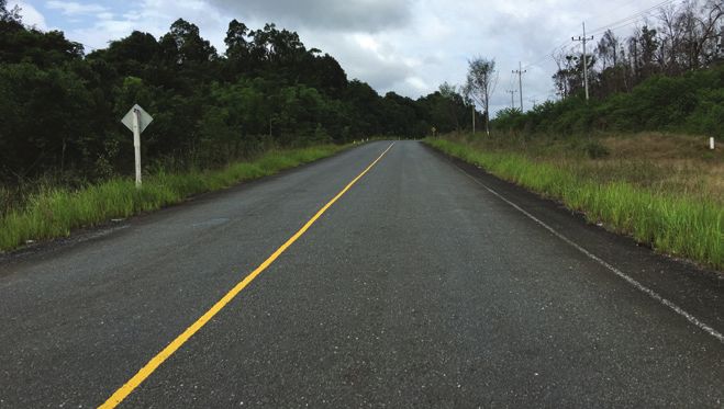
T
      he Assessment of Greater Mekong Subregion (GMS) Economic Corridors consists of six country reports
      and an integrative report prepared by a study team composed of Filologo Pante, Jr. (team leader),
      Josephine Duque-Comia of the GMS Secretariat, Hir Samnang (Cambodia), Sengsavang Phandanouvong
(Lao People’s Democratic Republic), Phyo Kyaw Thu (Myanmar), Liu Zengjun (People’s Republic of China),
Pawat Tantrongjita (Thailand), and Pham Thanh Tung (Viet Nam). Cuong Minh Nguyen of the GMS Secretariat
provided overall guidance and coordinated with GMS countries, while Cira Rudas and Rowena Sancio (GMS
Secretariat) assisted in finalizing the reports. Concerned ministries and agencies in the GMS countries extended
valuable cooperation and support in the conduct of the assessment.

All photos in this report except those on the cover were taken by Hir Samnang.

vi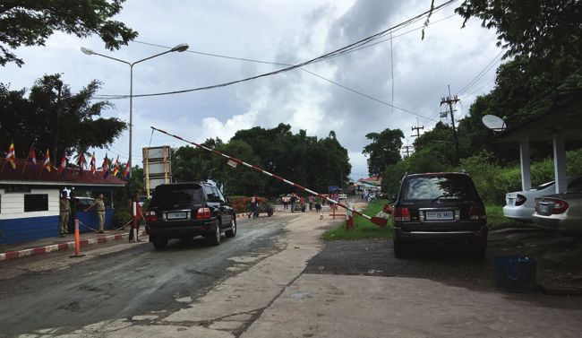
I. INTRODUCTION

T
       he development of transport corridors as                    of the Lao People’s Democratic Republic (PDR) and
       economic corridors has been at the center of                Myanmar in EWEC and NSEC; (ii) absence of Yangon,
       the Greater Mekong Subregion (GMS) Program                  Nay Pyi Taw, and Vientiane in any economic corridor;
since the GMS countries adopted the economic                       and (iii) omission of the principal cross-border trade
corridor approach in 1998. Economic corridors                      routes between the People’s Republic of China (PRC)
are geographically defined areas that facilitate the               and Myanmar, Myanmar and Thailand, and Lao PDR,
national and transnational movement of people,                     the PRC, and Thailand in the economic corridors.1
goods, services, capital, and information. They are                Figure 1 shows the new configuration of the GMS
key instruments for promoting economic integration                 economic corridors.
in the GMS. Along this line, the East–West Economic
Corridor (EWEC), North–South Economic Corridor                     The adoption of a new configuration of the GMS
(NSEC), and Southern Economic Corridor (SEC) were                  economic corridors underscored the need to
designated as flagships of the GMS Program.                        conduct an assessment of the state of development
                                                                   of the corridors to guide future investments and
A review of the configuration of the economic                      other interventions for their development. This
corridors was conducted in 2016 to take into account               report presents the findings of the assessment of
the opening up of Myanmar and ensure that (i) there                the Cambodia component of the GMS economic
is a close match between corridor routes and trade                 corridors focusing on (i) the status and physical
flows; (ii) GMS capitals and major urban centers are               condition of transport infrastructure and cross-
connected to each other; and (iii) the corridors are               border facilities, with emphasis on road transport; (ii)
linked with maritime gateways.                                     cross-border transport and trade; and (iii) economic
                                                                   potential (special economic zones, tourist attractions,
At the 21st GMS Ministerial Conference in Chiang                   and investment opportunities along and around the
Rai, Thailand on 30 November–1 December 2016, the                  economic corridors). The observations regarding
GMS ministers endorsed the recommended changes                     the physical condition of the roads in the SEC in
in the configuration of the economic corridors which               Cambodia are based on the field survey conducted in
addressed the following gaps: (i) limited involvement              June 2017.

1
    Asian Development Bank. 2018. Review of Configuration of Greater Mekong Subregion Economic Corridors. Manila.
    https://www.adb.org/documents/review-configuration-gms-corridors.

                                                                                                                          1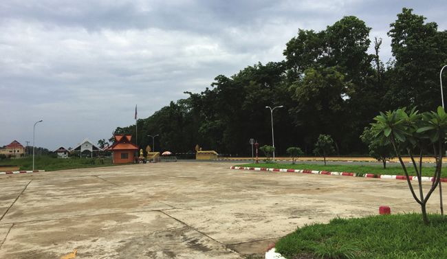
2   Assessment of Greater Mekong Subregion Economic Corridors: Cambodia

                Figure 1: New Configuration of the Greater Mekong Subregion Economic Corridors

      Source: Asian Development Bank. 2018. Review of Configuration of Greater Mekong Subregion Economic Corridors. Manila. https://
      www.adb.org/documents/review-configuration-gms-corridors.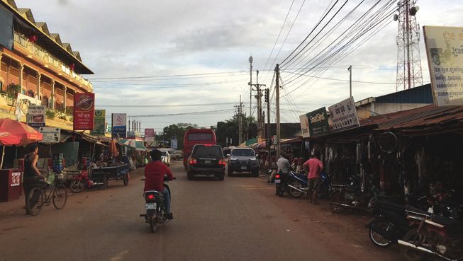
II. GREATER MEKONG SUBREGION
                       SOUTHERN ECONOMIC CORRIDOR
                                        IN CAMBODIA

T
     he GMS SEC consists of four subcorridors,                  (iii) Bangkok–Trat–Kampot–Ha–Tien–Nam Can
     all of which run through Cambodia’s territory                    Subcorridor (SEC-3)
     (Figure 2):                                                (iv) Sihanoukville–Phnom Penh–Stung Treng–Pakse-
                                                                      Savannakhet Subcorridor (SEC-4)
(i) Dawei–Bangkok–Phnom Penh–Ho Chi Minh City–
     Vung Tau Subcorridor (SEC-1)                               The four SEC subcorridors in Cambodia cover 21 of
(ii) Bangkok–Siem Reap–Stung Treng–Pleiku–Quy                   the 25 provinces and municipalities of the country with
     Nhon Subcorridor (SEC-2)                                   a total land area of 156,223 square kilometers (km2),

      Figure 2: Dawei–Bangkok–Phnom Penh–Ho Chi Minh City–Vung Tau, Bangkok–Siem Reap–
    Stung Treng–Pleiku–Quy Nhon, Bangkok–Trat–Kampot–Ha Tien–Nam Can, and Sihanoukville–
               Phnom Penh–Stung Treng–Pakse–Savannakhet Subcorridors in Cambodia

  Source: ADB. Greater Mekong Subregion Economic Corridor Assessment Team.

                                                                                                                     3
4 Assessment of Greater Mekong Subregion Economic Corridors: Cambodia
86% of the land area; and a combined population of Table 1 shows basic information on the Cambodia
14.28 million people, 94% of the country’s population. component of SEC-1, including the distances between
the main cities and provincial towns it traverses in
the country. The distance of the overlapping routes
A. D
awei–Bangkok–Phnom Penh– from the cross-border town, Poipet, to the provincial
Ho Chi Minh City– town of Banteay Meanchey, Sisophon, is 47 km.
Vung Tau Subcorridor Due to cross-border activities, Poipet town is larger
than Sisophon.
SEC-1 in Cambodia starts from Poipet in the
Cambodia–Thailand border and ends in Bavet at the The route from Poipet to Phnom Penh going through
Cambodia–Viet Nam border. From Poipet, it heads Battambang, Pursat, and Kampong Chhnang provinces
toward Sisophon of Banteay Meanchey province runs on National Road (NR) No. 5, which is mostly
from where there are two ways to reach Phnom Penh. class III, except a 47 km section from Poipet to
The first route goes through Battambang, Pursat, and Sisophon (class II), and another 30 km section from
Kampong Chhnang provinces, while the second which Preach Kdam to Phnom Penh (class I).2 The section
is 61 kilometers (km) longer than the first, goes through from Preach Kdam to Sisophon is being widened to
Siem Reap and Kampong Thom provinces. From four lanes with asphalt concrete (AC) surfacing. To
Phnom Penh, SEC-1 runs through Kandal, Prey Veng, reduce traffic at main cities, town bypass roads will be
and Svay Rieng provinces to Bavet. constructed at Sisophon, Battambang provincial town,
Table 1: Basic Information on the Cambodia Component of Dawei–Bangkok–Phnom Penh–
Ho Chi Minh City–Vung Tau Subcorridor (SEC-1)
Starting Point End Point Routes Distance Traffic Surface Class
(km) Lanes Type
(1 and 2) Poi Pet Sisophon AH1 (NR5) 47 2 AC II
(1) Sisophon Battambang AH1 (NR5) 70 2 DBST III
(2) Sisophon Siem Reap AH21(NR6) 105 2 AC II
(1) Battambang Pursat AH1 (NR5) 104 2 DBST III
(2) Siem Reap Kampong Thom NR6 147 2 AC II
(1) Pursat Kampong Chhnang AH1 (NR5) 95 2 DBST III
(2) Kampong Thom Kampong Thmar NR6 39 2 AC II
(1) Kampong Chhnang Preach Kdam AH1 (NR5) 61 2 DBST III
(2) Kampong Thmar Skun NR6 55 2 AC II
(1) Preach Kdam Phnom Penh AH1 (NR5) 30 4 AC I
(2) Skun Phnom Penh AH11 (NR6A) 75 4 AC I
(1 and 2) Phnom Penh Neak Loeung AH1 (NR1) 60 2 AC II
(1 and 2) Neak Loeung Svay Rieng AH1 (NR1) 65 2 DBST III
(1 and 2) Svay Rieng Bavet AH1 (NR1) 42 2 DBST III
Overall Length: Poi Pet–Bavet (1) 574
(2) 635
AC=asphalt concrete, AH= Asian Highway, DBST= double bituminous surface treatment, km = kilometer, NR = National Road.
Note: (1 and 2): overlapping sections between first and second routes of SEC-1; (1): first route of SEC-1, (2): second route of SEC-1.
Source: ADB. Greater Mekong Subregion Economic Corridor Assessment Team.
2
Class I: Highways with four or more lanes with AC or Concrete Pavement; Class II: Roads with two or more lanes with AC or
Concrete Pavement; Class III: Narrow two-lane roads with double bituminous surface treatment (DBST) pavement.Greater Mekong Subregion Southern Economic Corridor in Cambodia 5
Pursat provincial town, Kampong Chhnang provincial shows basic information on the Cambodia component
town, and Udong town. of SEC-2, including the distances between the main
cities and provincial towns it traverses in the country.
The route from Sisophon to Phnom Penh going The roads traversed by SEC-2 in Cambodia (NR Nos.
through Siem Reap and Kampong Thom provinces 5, 6, 64, 62, 9, 7, and 78) are either class II or class III.
runs on NR No. 6, which is mostly class II, except a
75 km section from Skun to Phnom Penh recently
widened to four lanes. From Phnom Penh to Bavet, C. B
angkok–Trat–Kampot–
SEC-1 runs on NR No. 1, which is class II. Ha Tien–Nam Can Subcorridor
SEC-3 in Cambodia starts from Koh Kong at the
B. B
angkok–Siem Reap– Cambodia–Thailand border, traverses Sihanoukville,
Stung Treng–Pleiku–Quy Nhon Kampot, and Kep provinces; and ends in Lork at the
Subcorridor Cambodia–Viet Nam border. Having an overall length
of 307 km, it connects via AH 123, Cambodia’s border
SEC-2 in Cambodia starts from Poipet at the crossing with Thailand at Koh Kong, and Cambodia’s
Cambodia–Thailand border, traverses Banteay border crossing with Viet Nam at Lork. Table 3 shows
Meanchey, Siem Reap, Preah Vihear, Stung Treng, basic information on the Cambodia component of SEC-
and Ratanakiri provinces; and ends in Oh Yadav at 3, including the distances between the main cities and
the Cambodia–Viet Nam border. Having an overall provincial towns it traverses in the country. The distance
length of 665 km, it connects via Asian Highway between Koh Kong provincial town and Kampot
(AH) 21, Cambodia’s main border with Thailand and provincial town is 253 km. The roads traversed by SEC-3
Cambodia’s border with Viet Nam at O Yadav. Table 2 in Cambodia (NR Nos. 48, 4, 3, and 33) are class III.
Table 2: Basic Information on the Cambodia Component of Bangkok-Siem Reap-Stung Treng-Pleiku-
Quy Nhon Subcorridor
Starting Point End Point Routes Distance Traffic Surface Class
(km) Lanes Type
Poi Pet Sisophon AH1 (NR5) 48 2 AC II
Sisophon Siem Reap AH21 (NR6) 105 2 AC II
Siem Reap Dam Dek AH21 (NR6) 33 2 AC II
Dam Dek Koh Ke AH21 (NR64) 80 2 DBST III
Koh Ke Preah Vihear AH21 53 2 DBST III
(Tbaeng Meanchey) (NR64, NR 62)
Preah Vihear Stung Treng AH21 (NR9) 143 2 DBST III
Stung Treng Rattanak Kiri (Bang AH21 (NR7, 135 2 DBST III
Lung) NR78)
Rattanak Kiri (Bang O Yadav, Viet Nam AH21 (NR78) 68 2 AC II
Lung) Border
Overall Length: Poi Pet–O Yadav 665
AC=asphalt concrete, AH= Asian Highway, DBST= double bituminous surface treatment, km = kilometer, NR = National Road.
Source: ADB. Greater Mekong Subregion Economic Corridor Assessment Team.6 Assessment of Greater Mekong Subregion Economic Corridors: Cambodia
Table 3: Basic Information on the Cambodia Component of Bangkok–Trat–Kampot–Ha Tien–
Nam Can Subcorridor
Starting Point End Point Routes Distance Traffic Surface Class
(km) Lanes Type
Koh Kong Sre Ambel, AH123 (NR48) 159 2 DBST III
connecting NR4
Sre Ambel Veal Rign AH123 (NR4) 40 2 AC II
Veal Rign Kampot AH123 (NR3) 54 2 DBST III
Kampot Kampong Trach AH123 (NR33) 37 2 DBST III
Kampong Trach Lork Vietnamese AH123 (NR33) 17 2 DBST III
border
Overall Length: Koh Kong–Lork 307
AC=asphalt concrete, AH= Asian Highway, DBST= double bituminous surface treatment, km = kilometer, NR = National Road.
Source: ADB. Greater Mekong Subregion Economic Corridor Assessment Team.
Speu, Kandal, Kampong Cham, Tbong Khmum,
D. S
ihanoukville–Phnom Kratie, and Stung Treng provinces; and ends in
Penh–Stung Treng–Pakse– Trapeang Kriel at the Cambodia–Lao PDR border.
Savannakhet Subcorridor Having an overall length of 750 km, it connects via
AH11 Cambodia’s main deep-sea port in Sihanoukville
SEC-4 in Cambodia starts from Sihanoukville to Cambodia’s border crossing with Lao PDR at
provincial town, traverses Phnom Penh, Kampong Trapeang Kriel. Table 4 shows basic information on
Table 4: Basic Information on the Cambodia Component of Sihanoukville–Phnom Penh–Stung Treng–
Pakse–Savannakhet Subcorridor
Starting Point End Point Routes Distance Traffic Surface Class
(km) Lanes Type
Sihanouk Ville (SHV) Kampong Speu AH11 (NR4) 182 2 AC II
(Chba Mon)
Kampong Speu Thnol Toteung AH11 (NR4) 18 2 AC II
(Chba Mon)
Thnol Toteung Phnom Penh AH11 (NR4) 30 4 AC I
Phnom Penh Skun AH11 (NR6A) 75 4 AC I
Skun Kampong Cham AH11 (NR7) 45 2 AC II
Kampong Cham Thbong Khmum AH11 (NR7) 36 2 DBST III
(Soung)
Thbong Khmum Kratie AH11 (NR7) 174 2 DBST III
(Soung)
Kratie Stung Treng AH11 (NR7) 127 2 DBST III
Stung Treng Trapeang Kriel (Lao AH11 (NR7) 63 2 DBST III
border)
Overall Length: Sihanoukville–Trapeang Kriel 750
AC=asphalt concrete, AH= Asian Highway, DBST= double bituminous surface treatment, km = kilometer, NR = National Road.
Source: ADB. Greater Mekong Subregion Economic Corridor Assessment Team.Greater Mekong Subregion Southern Economic Corridor in Cambodia 7 the Cambodia component of SEC-4, including the by SEC-4 in Cambodia (NR Nos. 4, 6A, and 7) are distances between the main cities and provincial class II, except a 105 km section from Thnol Toteung towns it traverses in the country. The roads traversed to Skun, which is class I.
III. STATE OF ROAD TRANSPORT
AND RELATED TRANSPORT DEVELOPMENT
IN THE SOUTHERN ECONOMIC CORRIDOR
IN CAMBODIA

A. D
    awei-Bangkok-Phnom Penh-                                              Sisophon–Battambang, Battambang–Pursat, and
   Ho Chi Minh City-Vung Tau                                               Pursat–Preach Kdam sections are being upgraded to
   Subcorridor                                                             four lanes with AC surfacing to be completed by 2018

S
                                                                           (Sisophon–Battambang), 2019 (Battambang–Pursat)
       EC-1 from the Cambodia–Thai border to Phnom                         and 2020 (Pursat–Preach Kdam).
       Penh has two alternative routes. The first route
       runs along NR No. 5, while the second route                         Along the second route of SEC-1, which overlaps with
runs on NR No. 6. The two routes converge in Phnom                         SEC-2, the 105 km section from Sispohon to Siem
Penh and then continue along NR No. 1 from Phnom                           Reap is a two-lane AC road and is in good condition
Penh to the Cambodia–Viet Nam border. Table 5                              (see the figures below). The 50 km section from
summarizes the condition of the roads along SEC-1                          Kralanh to Siem Reap is being improved by pavement
in Cambodia. The first section of 48 km of NR No. 5                        strengthening, resurfacing with AC, and installation of
from Poi Pet to Siphon, which overlaps with SEC-2, was                     side drainage with 5-year hybrid performance-based
first rehabilitated with AC surfacing starting in 2006                     contract under the Road Network Improvement
and completed in 2008. This road section is regularly                      Project, approved by the Asian Development Bank
maintained and in good condition (see the next                             (ADB) in January 2018. Another section of the
two photos).                                                               second route of SEC-1 from Siem Reap town to Skun
                                                                           was first rehabilitated as a DBST road in 2004 under
Another section of NR No. 5 along the first route of                       a loan from ADB, and was further upgraded to AC
SEC-1 from Sisophon to Phnom Penh with a total                             by a loan from the PRC in 2017. This road section is
length of 422 km was rehabilitated with two-lane                           in good condition. The 75 km section from Skun to
double bituminous surface treatment (DBST) starting                        Phnom Penh, overlapping with the SEC-4, was first
in 2000 and completed in 2004 (see the next three                          rehabilitated as a two-lane AC road in two sections in
photos). Upgrading to four lanes with AC surfacing of                      1995 and 1999 with a grant from the Government of
the 30 km stretch from Phnom Penh to Preach Kdam                           Japan. This road section was upgraded to four lanes
was just completed under a loan from the PRC. This                         with AC surfacing in early 2017 under a loan from
is in very good condition (see the photo below). The                       the PRC.

Left and right photos. Different sections of Poi Pet–Sisophon. The first section of NR No. 5 from Poi Pet to Siphon was first rehabilitated with
asphalt concrete surfacing starting in 2006 and completed in 2008. Hence, this road section is regularly maintained and in good condition.

8
State of Road Transport and Related Transport Development in the Southern Economic Corridor
in Cambodia 9
Table 5: State of Dawei–Bangkok–Phnom Penh–Ho Chi Minh City–Vung Tau Subcorridor Roads
in Cambodia
Section Routes Traffic Surface State of Remarks
Lanes Type Road
(1 and 2) Poi Pet– AH1 (NR5) 2 AC G AC completed in 2008 (ADB and
Sisophon Organization of the Petroleum Exporting
Countries loans). Town bypass at Sisophon
13.4 km by 2018 (Japan loan).
(1) Sisophon– AH1 (NR5) 2 DBST F Widening to 4 lanes with AC and Battambang
Battambang town bypass of 23.1 km will be completed by
2018 (Japan loans).
(2) Sisophon–Siem AH21(NR6) 2 AC G AC completed in 2008 (ADB loan).
Reap
(1)Battambang– AH1 (NR5) 2 DBST F Widening to four lanes with AC and Pursat
Pursat town bypass will be completed by 2019 (Japan
loans).
(2) Seim Reap– NR6 2 AC G
Kampong Thom Rehabilitated under ADB loan as DBST road
in 2004, then upgraded to AC in 2017 through
PRC loan.
(1) Pursat– AH1 (NR5) 2 DBST F Widening to four lanes with AC and Kampong
Kampong Chhnang Chhnang town bypass of 11.8 km will be
completed by 2020 (Japan loans).
(2) Kampong NR6 2 AC G Rehabilitated under ADB loan as DBST road
Thom–Kampong in 2004, then upgraded to AC in 2017 through
Thmar PRC loan.
(1) Kampong AH1 (NR5) 2 DBST F Widening to four lanes with AC and town
Chhnang–Preach bypass of 4.9 km will be completed by 2020
Kdam (Japan loans).
(2) Kampong NR6 2 AC G Rehabilitated under ADB loan as DBST road
Thmar– Skun in 2004, then upgraded to AC in 2017 through
PRC loan.
(1) Preach Kdam– AH1 (NR5) 4 AC G Upgraded to four lanes with AC (PRC loan,
Phnom Penh 2017).
(2) Skun–Phnom
Penh AH11 4 AC G
(NR6A) Upgraded to four lanes with AC (PRC loan,
2017).
(1 and 2) Phnom AH1 (NR1) 2 AC G AC completed in 2009 for 43 km from Neak
Penh–Neak Loeung Loeung.
(1 and 2) Neak AH1 (NR1) 2 DBST G DBST completed in 2004 (ADB loan);
Loeung–Svay Rieng maintenance and upgrading (World Bank loan,
2011–2013).
(1 and 2) Svay AH1 (NR1) 2 DBST G DBST completed in 2004 (ADB loan);
Rieng– Bavet maintenance and upgrading (World Bank loan,
2011–2013).
AC=asphalt concrete, ADB = Asian Development Bank, AH= Asian Highway, DBST= double bituminous surface treatment, F = fair, G = good,
km = kilometer, NR = National Road, PRC = People’s Republic of China.
Source: ADB. Greater Mekong Subregion Economic Corridor Assessment Team.10 Assessment of Greater Mekong Subregion Economic Corridors: Cambodia
Left: Sisophon–Battambang. Right: Battambang–Kampong Chnang. The pictures show the existing road condition before the upgrading
and widening through a loan from Japan.
Left: Kampong Chhnang–Preach Kdam. Existing road condition before it was upgraded and widened to four lanes by Japanese loans. Right:
Preach Kdam–Phnom Penh. Road condition after recent upgrading and widening by Chinese loan.
Alongside NR No. 5, a 386 km, 1-meter (m) gauge with two-lane AC surfacing. The rehabilitation of a
Northern Railway Line, which was first constructed 4 km section from Phnom Penh, which is in very good
in 1929–1942, is being rehabilitated by the Royal condition, was completed in 2016. Rehabilitation of
Government of Cambodia (RGC) following the the remaining parts of the road was completed in
completion of the rehabilitation of 65 km of the 2009 and 2011. These are in good condition (see the
line, of which 42 km is from Poi Pet to Sisophon, photo below).
rehabilitated with ADB funding.3 The RGC is seeking
urgent financial assistance from the PRC to build the At Neak Loeung, a cable-stayed bridge with a
256 km missing link from Bat Doeng to Loc Ninh in total length of 2,215 m, funded by a grant from the
the Cambodia–Viet Nam border within the framework Government of Japan, was completed in 2015.4 The
of the Singapore–Kunming Rail Link (SKRL) project of remaining section of NR No. 1 from Neak Loeung to
the Association of Southeast Asian Nations. the Cambodia–Viet Nam border was first rehabilitated
with two-lane DBST surfacing in 1999 and completed in
Due to complicated resettlement issues in densely 2004 through a loan from ADB. The road section was
populated areas, the section of NR No. 1 from Phnom later included under a maintenance project funded by
Penh to Neak Loeung was rehabilitated part by part the World Bank (WB) from 2009 to 2013 (see photo
3
ADB. 2016. “GMS Rehabilitation of the Railway in Cambodia Progress Report,” as of 10 May 2016.
4
Ministry of Public Works and Transport, Government of Cambodia. 2015. Overview of Transport Infrastructure Sector in the Kingdom
of Cambodia (5th Edition). Phnom Penh.State of Road Transport and Related Transport Development in the Southern Economic Corridor
in Cambodia 11
Left: Phnom Penh–Neak Leoung. Existing condition of asphalt concrete road. Right: Neak Leoung–Bavet Border. Double bituminous
surface treatment road before resurfacing by asphalt concrete under an ADB loan.
below). This section is also being improved by pavement volume is about five times less than the export volume.
strengthening, resurfacing with AC, and installation of SEC-1 in Cambodia is also connected to a dry port at
side drainage with 5-year hybrid performance-based the Bavet border called So Nguon Dry Port.
contract under the Road Network Improvement Project
approved by ADB in January 2018. In short, the current condition of SEC-1 roads in
Cambodia ranges from fair to good. By 2020, more than
The Japan International Cooperation Agency (JICA) 350 km of the 577 km of SEC-1 roads in Cambodia will
conducted studies on a six-lane expressway from Phnom be upgraded to four lanes (class I). Routine and periodic
Penh to Bavet with an approximate length of 130 km. maintenance of the Phnom Penh to Neak Loeung
Cambodia and Viet Nam signed a memorandum of section needs to be regularly carried out to keep the
understanding covering this expressway in April 2017 road in good condition. The section from Neak Loeung
during the 3-day official visit of Viet Nam’s Prime Minister to the Cambodia–Viet Nam border will be strengthened
Nguyen Xuan Phu to Cambodia. The memorandum by additional base-course surfacing with AC and
of understanding is expected to pave the way for the installation of necessary side drainage.
conduct of a feasibility study on the proposed expressway
by the two countries. Traffic data collected by the Ministry of Public Works
and Transport (MPWT) at key sections in 2015 are in
There is an inland waterway port in Phnom Penh, Appendix 1. Depending on location, the annual average
which is along SEC-1 in Cambodia. The Phnom Penh daily traffic varies from 10,529 passenger car units
Autonomous Port (PPAP) in the city, about 4 km from (PCUs) to 27,154 PCUs.
the Tonle Sap–Mekong River junction on the Tonle
Sap, is accessible by vessels from the South China Sea
through Viet Nam. In response to the sharp increase B. B
angkok–Siem Reap–
in shipment moving through Cambodia, a new 25 km Stung Treng–Pleiku–Quy Nhon
cargo terminal was constructed downstream in January Subcorridor
2013 with financial support from the PRC.
SEC-2 in Cambodia runs along NR No. 5 from Poipet
According to the PPAP, the annual increase in cargo to Sisophon (overlapping with SEC-1), then on NR No.
throughput averaged 20% from 2003 to 2007. The 6 from Sisophon to Dam Dek, NR No. 64 from Dam
cargo traffic declined in 2009 due to the 2007–2008 Dek to Thmei, NR No. 62 from Thmei to Preah Vihear
global financial crisis. The cargo throughput started to (Thbeng Meanchey), NR No. 9 from Preah Vihear to
increase after the opening of the Cai Mep Hub Port Stung Treng, NR No. 7 from Stung Treng provincial
in Viet Nam: by 31% in 2011, 17% in 2012, 16% in 2013, town to O Pong Mon, and NR No. 78 from O Pong
21% in 2014, and 8% in 2015. The cargo throughput in Mon to the Cambodia–Viet Nam border. Table 6
2015 was 144,813 twenty-foot equivalent units (TEUs), summarizes the condition of the roads along SEC-2
and the forecast for 2016 is 165,000 TEUs. The import in Cambodia.12 Assessment of Greater Mekong Subregion Economic Corridors: Cambodia
The section from the Cambodia–Thailand border by pavement strengthening, resurfacing with AC,
to Dam Dek (184 km) is two-lane AC and in good and installation of side drainage with 5-year hybrid
condition (see the photos below). Of the 184 km, performance-based contract under the Road Network
50 km from Kralanh to Siem Reap is being improved Improvement Project approved by ADB in January 2018.
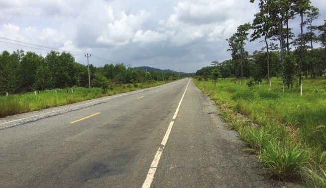
Left and right photos: Sections of Sisophon–Siem Reap. Asphalt concrete road was completed in 2008.
Table 6: State of Bangkok–Siem Reap–Stung Treng–Pleiku–Quy Nhon Subcorridor Roads in Cambodia
Section Routes Traffic Surface State of Remarks
Lanes Type Road
Poi Pet–Sisophon AH1 (NR5) 2 AC G AC completed in 2008 (ADB and
Organization of the Petroleum Exporting
Countries loans).
Sisophon–Siem AH21 (NR6) 2 AC G AC completed in 2008 (ADB loan).
Reap
Siem Reap– Dam AH21 (NR6) 2 AC G
Dek
Dam Dek–Koh Ke AH21 DBST F DBST, 2003 under BOT.
(NR64) Improvement is needed.
Koh Ke–Preah AH21 2 DBST G DBST completed in 2012 (PRC loan).
Vihear (NR64 and
NR62)
Preah Vihear–Stung AH21 (NR9) 2 DBST G DBST completed in 2014 (PRC loan).
Treng
Stung Treng– AH21 (NR7 2 DBST G DBST NR7 completed in 2007 and NR78
Rattanak Kiri and NR78) completed in 2013 (PRC loan).
Rattanak Kiri–O AH21 2 AC G AC completed in 2009 (Viet Nam loan).
Yadav (NR78)
AC=asphalt concrete, AH= Asian Highway, BOT = build–operate–transfer, DBST= double bituminous surface treatment, F = fair, G = good,
km = kilometer, NR = National Road, PRC = People’s Republic of China.
Source: ADB. Greater Mekong Subregion Economic Corridor Assessment Team.
Another 80 km section of SEC-2 from Dam Dek to 2003. Operation of this section has been transferred to
Koh Ke was constructed under a build–operate– the government. The road, which is narrow at market
transfer (BOT) arrangement with a two-lane DBST in areas, is in fair condition (see the photos below).State of Road Transport and Related Transport Development in the Southern Economic Corridor
in Cambodia 13
Left and right photos: Sections of Dam Dek–Koh Ke. Existing road condition at market areas and at village areas.
The other 53 km section from Koh Ke to Tbeng to a two-lane DBST in 2009 through a loan from
Meanchey (Preah Vihear) and 143 km section from the PRC. Rehabilitation of the road was completed
Tbeng Meanchey to Stung Treng were rehabilitated in in 2013. This road section is still in good condition
2008 with a two-lane DBST surfacing through a loan (see the photo below). The last section of SEC-2 in
from the PRC. Rehabilitation of these road sections Cambodia is the 68 km stretch from Bang Lung to the
was completed in 2012 and 2014. Both road sections O Yadav border with Viet Nam. This road section was
are in good condition (see the photos below). rehabilitated to two-lane AC in 2007 through a loan
from Viet Nam. Rehabilitation of this road section was
The 135 km section from Stung Treng to Bang Lung completed in 2009. It is also in good condition (see the
(Ratanak Kiri) along NR No. 78 was rehabilitated photo below).
Left: Koh Keh–Tbeng Meanchey: Part of the 53 km road from Koh Ke to Tbeng Meanchey. Right: Tbeng Meanchey–Stung Treng: The road
was rehabilitated in 2008 with double bituminous surface treatment surfacing.
Left: O Pong Mon–Bang Lung. Condition of road in NR No. 78. Right: Bang Lung–O Yadav Border. Part of the 68 km road from Bang Lung
to O Yadav in the Cambodia-Viet Nam border.14 Assessment of Greater Mekong Subregion Economic Corridors: Cambodia
As a whole, the SEC-2 roads in Cambodia are in good Table 7 summarizes the condition of the roads along
condition, except for 80 km out of 665 km (12%) which SEC-2 in Cambodia.
is in fair condition. Periodic maintenance, road widening,
and side drainage along the populated areas along the The 159 km section of NR No. 48 was rehabilitated
80 km Dam Dek–Koh Ke road section are necessary to to a two-lane DBST in 2004 through a loan from the
improve its state from fair to good condition. Government of Thailand. Rehabilitation of this road
was completed in 2007. A major part of this road
Traffic data collected by MPWT at key sections in is in good condition, except where the government
2015 are in Appendix 1. Available traffic data for this is carrying out spot periodic maintenance (see the
subcorridor in Cambodia is limited. Only traffic data photo below). This road section will be improved to
on NR No. 6 from Banteay Meanchey to Siem Reap, AC surfacing in 2018 with a loan of $75.7 million from
which has generally much higher traffic than other road the Economic Development Cooperation Fund and
sections of SEC-2, is available. Depending on location, Export–Import Bank of the Republic of Korea.
the annual average daily traffic varies from 11,920
PCUs to 22,964 PCUs. The 40 km Sre Ambel–Veal Rign section along NR
No. 4 was rehabilitated in 1996 with funding from the
United States (US). This road section was under an
C. B
angkok–Trat–Kampot–Ha Tien– operate–transfer–maintenance arrangement from
Nam Can Subcorridor 2001 to 2016 with a local private company. This road
section is in good condition.
SEC-3 in Cambodia runs along NR No. 48, from the
Koh Kong border with Thailand to the Sre Ambel Upgrading and periodic maintenance of the 54 km Veal
junction; on NR No. 4, from Sre Ambel to the Veal Rign–Kampot section on NR No. 3 was undertaken
Rign junction; on NR No. 3, from Veal Rign to Kampot under an ADB-funded project from 2011 to 2014. This
provincial town; and along NR No. 33, from Kampot road section is now under a WB project for pavement
provincial town to Lork at the border with Viet Nam. strengthening, resurfacing with AC, and installation of
Table 7: State of Bangkok–Trat–Kampot–Ha Tien–Nam Can Subcorridor Roads in Cambodia
Section Routes Traffic Surface State of Remarks
Lanes Type Road
Koh Kong–Sre AH123 2 DBST G DBST completed in 2007 (Thailand loan). Will
Ambel connecting (NR48) be improved with AC by $75.7 million loans
to NR4 from the Economic Development Cooperation
Fund and Export–Import Bank.
Sre Ambel–Veal AH123 2 AC G AC completed in 1996 (US loan), maintenance
Rign (NR4) under operate–transfer from 2001 to January
2016.
Veal Rign–Kampot AH123 2 DBST G DBST completed in 2014 (ADB Loan), 2017–
(NR3) 2022 (maintenance World Bank loan, AC).
Kampot–Kampong AH123 2 DBST G DBST completed in 2005 (World Bank loan)
Trach (NR33)
Kampong Trach– AH123 2 DBST G DBST completed in 2010, ADB loan.
Lork (NR33)
AC=asphalt concrete, AH= Asian Highway, DBST= double bituminous surface treatment, G = good, NR = National Road.
Source: ADB. Greater Mekong Subregion Economic Corridor Assessment Team.State of Road Transport and Related Transport Development in the Southern Economic Corridor
in Cambodia 15
side drainage using a performance-based maintenance To recap, the whole length of SEC-3 roads in Cambodia
model from 2017 to 2022. This road section is in is class III and generally in good condition. However,
good condition. side drainage, especially in populated areas, should be
installed to prevent premature damage of the roads.
The last two sections on NR No. 33, the 37 km stretch
from Kampot to Kampong Trach and 16 km from Traffic data collected by MPWT in 2015 at key sections
Kampong Trach to Lork were rehabilitated to two-lane are provided in Appendix 1. Available traffic data on this
DBST in 2003 (Kampot to Kampong Trach) and 2007 subcorridor in Cambodia is limited. Only traffic data
(Kampong Trach to Lork). The rehabilitation of these on NR No. 3 from Vealrign to Kampot, where traffic is
roads were completed in 2005 (Kampot to Kampong generally higher than other road sections in SEC-3, is
Trach) and 2010 (Kampong Trach to Lork). Both road available. Depending on location, the annual average
sections are in good condition (see the photo below). daily traffic varies from 5,977 PCUs to 13,961 PCUs.
Left: Koh Kong-Sre Ambel. SEC-3 in Cambodia along NR No. 48. Right: Kampong Trach-Lork. Two lane double bituminous surface
treatment road completed with an ADB loan in 2010.
for upgrading and maintenance of the road under this
D. S
ihanoukville–Phnom project, which also includes further strengthening
Penh–Stung Treng–Pakse– of the road pavement with additional base-course,
Savannakhet Subcorridor application of new AC on the carriage way and
shoulder, and installation of side drainage.
SEC-4 runs along NR No. 4 from Sihanoukville to
Phnom Penh, along NR No. 6A from Phnom Penh to A 264 km, 1 m gauge Southern Railway Line,
Skun, and along NR No. 7 from Skun to the Lao PDR constructed in 1960–1969, runs parallel to NR No. 4.
border. Table 8 summarizes the condition of the roads The rehabilitation of this line was completed through a
along SEC-4 in Cambodia. loan from ADB. It is used mainly for transporting cargo.
The 226 km section of NR No. 4 was rehabilitated As part of the government’s expressway master plan
with two-lane AC in 1996 with US funding. The which estimates that the country will need 850 km
road was under an operate–transfer arrangement of expressways by 2020 at a cost of $9 billion, a BOT
for maintenance with a local private firm from 2001 contract for the 190 km expressway from Phnom Penh
to 2016. During this period, the 30 km section from to Sihanoukville was signed between the state-owned
Phnom Penh to Thnal Totoeng was widened to four Chinese Communications Construction Company
lanes (see the photo below). With regular maintenance Ltd (CCCC) and MPWT in January 2018 with a value
by the government, the road is in good condition. of $1.9 billion. The start date for construction has
NR No. 4 will be included in the ongoing World Bank not yet been set, as an interministerial working group
Road Asset Management II (RAMP-II) project with is still studying the impact of the project on private
additional financing from 2019. An output-based properties along its length. The construction will take 4
performance maintenance contract will be applied years to complete.16 Assessment of Greater Mekong Subregion Economic Corridors: Cambodia
Table 8: State of Sihanoukville–Phnom Penh–Stung Treng–Pakse–Savannakhet Subcorridor Roads
in Cambodia
Section Routes Traffic Surface State of Remarks
Lanes Type Road
Sihanouk Ville AH11 2 AC G AC completed in 1996 (US), maintenance
(SHV)–Kampong (NR4) under OT from 2001 to January 2016.
Speu (Chba Mon
Kampong Speu AH11 2 AC G AC completed in 1996 (US), maintenance
(Chba Mon)–Thnol (NR4) under OT from 2001 to January 2016.
Toteung
Thnol Toteung– AH11 4 AC G AC completed in 1996 (US), maintenance
Phnom Penh (NR4) under OT from 2001 to January 2016.
Phnom Penh– Skun AH11 4 AC G Upgraded to four lanes with AC (PRC loan,
(NR6A) 2017).
Skun–Kampong AH11 2 AC G AC completed in 1999 under Japan grant
Cham (NR7) for maintenance and upgrading (WB loan
2011–2013)
Kampong Cham– AH11 2 DBST F DBST completed in 2004 (ADB loan)
Thbong Khmum (NR7) maintenance and upgrading (WB Loan
(Soung) 2011–2013)
Thbong Khmum AH11 2 DBST G DBST completed in 2004 (ADB loan)
(Soung) –Kratie (NR7) maintenance and upgrading (WB Loan
2011–2013)
Kratie–Stung Treng AH11 2 DBST P DBST completed in 2007 through PRC loan.
(NR7) Spot-improvement is being carried out.
Stung Treng– AH11 2 DBST P DBST completed in 2007 through PRC loan.
Trapeang Kriel (NR7) Spot-improvement is being carried out.
AC=asphalt concrete, AH= Asian Highway, DBST= double bituminous surface treatment, F = fair, G = good, km = kilometer, NR = National
Road, OT = operate–transfer, P = poor, PRC = People’s Republic of China. US = United States, WB = World Bank.
Source: ADB. Greater Mekong Subregion Economic Corridor Assessment Team.
Another section of SEC-4, NR No. 6A of 75 km length, the 164 km road section from the junction of NR No. 7
was first rehabilitated with two-lane AC in 1995 and and NR No. 11 in Tbong Khmom using a performance-
1999 under a grant from the Government of Japan.This based contract from 2017 to 2022 under a WB loan.
road section was upgraded to four lanes with AC and
completed in early 2017 through a loan from the PRC The last section of SEC-4 in Cambodia along NR No. 7
(see the photo below). from Kratie to Trapeang Kriel border with the Lao PDR
was rehabilitated in 2004 with two-lane DBST through
The 45 km section of SEC-4 along NR No. 7 from Skun a loan from the PRC. The rehabilitation of this road
to Kampong Cham was rehabilitated to two-lane AC in section was completed in in 2007. Most sections of
1999. The 10 km stretch from Kampong Cham to Chub the road are in poor condition. Spot repair of the road
was also rehabilitated to two-lane AC in 2003, with a which is being conducted through a loan from the PRC
grant from the Government of Japan, while the 205 km is ongoing and expected to be completed by 2018 (see
long section from Chub to Kratie was rehabilitated to the photos below).
two-lane DBST surfacing in 2004. From 2011 to 2013,
the 260 km section from Skun to Kratie was upgraded SEC-4 in Cambodia runs through the Phnom Penh
and maintained under a loan from the WB. Pavement Autonomous Port, similar to SEC-1. It also links the
strengthening, resurfacing with two-lane AC, and Sihanoukville Autonomous Port (PAS), which is the
installation of side drainage are being undertaken along sole deep seaport in Cambodia, to Phnom Penh andState of Road Transport and Related Transport Development in the Southern Economic Corridor
in Cambodia 17
Left: Thnol Toteung–Phnom Penh. Four lane highway with asphalt concrete. Right: Phnom Penh–Skun. Four lane highway with asphalt
concrete.
Left and right photos: Sections of Kratie–Stung Treng. Two lane double bituminous surface treatment road.
the Viet Nam border. The PAS is directly connected Many privately-owned dry ports are located along NR
to cargo southern railway line from Sihanoukville to No. 4 near Phnom Penh. The main dry ports, which
Phnom Penh. In the last 5 years, the volume of cargo are of international importance, are CWT dry port,
throughput in the PAS increased more than 10%, with Phnom Penh International port, Phnom Penh Special
the volume of cargo throughput in being equivalent to Economic Zone, Teng Lay dry port, Olair World dry
3.8 million tons, excluding 391,000 TEUs of containers, port and Tech Srun dry port.
in 2015. The port can accommodate vessels with
20,000 deadweight tonnage loading capacity or In brief, SEC-4 in Cambodia from Sihanoukville to
approximately 1,500 TEUs for container vessels. Kratie, which is 556 km long, is currently in good
condition. The 105 km Thnol Toteung–Skun stretch in
Besides the PAS, SEC-4 in Cambodia also runs through this section has been upgraded to a four-lane AC class
a privately-owned Oknha Mong Port, located 76 km I road. On the other hand, most of the road section
from Sihanoukville. The port, on a total land of 64 from Kratie to Trapeang Kriel in the border with Lao
hectares (ha) with a berth length of 1,111 m, started PDR is in poor condition and undergoing periodic
operation in 2004. Most of the transport through this maintenance. It is expected that after completion of
port is by wooden boats that carry cargo from Thailand periodic maintenance, possibly by 2018, this section
with a capacity of 300 tons and frequency of about will be in good condition.
35 to 50 boats per month. Another privately-owned
seaport called Stunghav Port is located 30 km from NR Appendix 1 shows traffic data collected by MPWT in
No. 4. The land area of the port and industries around 2015 at key sections of SEC-4 in Cambodia. Traffic data
it is about 520 ha of reclaimed land. The vessels using for this subcorridor is limited, as only traffic data on
the port mostly carry construction materials (350 tons small sections of NR No. 6 and NR No. 7, where traffic is
per vessel and 7 to 10 vessels per month). Vessels from generally higher than other sections in the subcorridor,
Thailand mostly carry general cargo (300 tons per are available. Depending on location, the annual average
vessel and three vessels per month). daily traffic varies from 13,561 PCUs to 23,087 PCUs.IV. BORDER CROSSING FACILITIES
IN THE SOUTHERN ECONOMIC CORRIDOR
IN CAMBODIA
T
he construction of new cross-border facilities Poipet included a two-story building with Cambodia’s
(CBF) at the Chhay Chhay Industrial Free Zone, traditional architecture, and a new tourist arrival
which is about 10 km north of the Poipet border building with a waiting area and toilet facilities. A CCA
post along SEC-1, was originally included in the GMS building with a common control inspection hall for
Cambodia Road Improvement Project.5 However, freight vehicles, and office facilities were built at Bavet.
this project component was canceled in 2008 due to These facilities were completed in 2010 when the
a border dispute and the inability of Cambodia and project also financed the repair of the roof of the Bavet
Thailand to agree on the location of the new border CBF damaged in a 2009 typhoon.
crossing point. The two countries also failed to agree
on another MPWT proposal involving another location Import volume widely exceeds export volume at
about 3 km south of Poipet. both border crossing points. At Poipet, main imports
are motor vehicles and machinery and equipment,
In 2009, MPWT proposed and ADB agreed to while Portland cement is the major export. At Bavet,
improve the existing CBF at Poipet and to provide the major imports are unmanufactured tobacco
a new common control area (CCA) building at the and furniture, while textiles and fabric are the
Bavet CBF (see the photos below). Improvements in major exports.6
Left: Sisophon–Siem Reap. Right: Viet Nam–Cambodia Bavet Border. Existing road condition at Cambodia–Thailand and Cambodia–
Viet Nam borders.
The Trapeang Kriel–Nong Nokkhiane border 10 January 2017 (see the photo below). This is
gate, which connects Cambodia’s northern Stung expected to help increase trade and tourism between
Treng province to Lao PDR’s southern Champasak the two countries.
province along SEC-4, is the sole official land crossing
between the two countries, and an artery for bilateral There is limited cross-border trade at O Yadav,
trade and investment. Cambodia and the Lao PDR Cambodia’s border crossing with Viet Nam along SEC‑2.
officially inaugurated newly constructed CBFs on BCFs in O Yadav are rudimentary (see the photo below).
5
ADB. 2011. Completion Report: GMS Cambodia Road Improvement Project in Cambodia. Manila.
6
JICA and WB. 2016. Logistics Situation and Challenges in Cambodia. Unpublished.
18Border Crossing Facilities in the Southern Economic Corridor in Cambodia 19
Left: Lao–Cambodia Trapeang Kriel Border. Right: Viet Nam-Cambodia O Yadav Border. Existing conditions at Cambodia–Lao and
Cambodia–Viet Nam borders.
Under the ADB-funded GMS Southern Costal in 2014. BCFs in Koh Kong were also planned to be
Corridor Project in Cambodia, a CCA building with a constructed under the original scope of the project,
common control inspection hall for freight vehicles but due to land acquisition problems, this subproject
and office facilities were built at Lork (see the figure was canceled. The existing BCF in Koh Kong is shown
below). Construction of these facilities was completed in the photo below.
Left: Viet Nam–Cambodia Lork Border. Right: Viet Nam–Thailand Koh Khong Border. Existing road condition at Cambodia-Viet Nam and
Cambodia-Thailand borders.
A memorandum of understanding on land transport the concerned countries. Official and diplomatic
among Cambodia, Viet Nam and the Lao PDR was cars can pass the borders of each country any time.
signed on 17 January 2013 to facilitate cross-border The numbers of vehicles allowed to enter their
land transport among them. Initially, 150 freight trucks respective territories under bilateral agreements
were allowed to cross each country. Later, this number among neighboring countries, Cambodia, the Lao PDR,
could be increased, subject to agreement among Thailand, and Viet Nam, are shown in Table 9 below.
Table 9: Number of Vehicles Allowed Entry under Bilateral Transport Agreements
Cambodia–Lao PDR Cambodia–Viet Nam Cambodia–Thailand
40 vehicles 500 vehicles 40 vehicles, to be increased to 500
vehicles in 2017
LAO PDR = Lao People’s Democratic Republic.
Source: Ministry of Public Works and Transport.V. INVESTMENT AND BUSINESS
OPPORTUNITIES IN THE SOUTHERN
ECONOMIC CORRIDOR IN CAMBODIA
A
s part of its National Strategic Development Presently, 37 SEZs have been established in Cambodia.
Plan 2014–2018, the government aims to Of the 37 SEZs, 17 SEZs are in the vicinity of SEC-
mobilize human, financial, and institutional 1. These are: Tai Seng Bavet SEZ, Manhattan (Svay
resources to support the establishment of new Reing) SEZ, Goldfame Pak Shun SEZ, D&M Bavet SEZ,
industries. This entails instituting and strengthening Phnom Penh SEZ, Poi Pet O’Neang SEZ, P (SEZ) I C,
special economic zones (SEZs) to attract foreign N.L.C SEZ, Hi-Park SEZ, Shandong Sunshell Svay Rieng
investment, encourage technology transfers, and SEZ, Zhong Jian Jin Bian Jing Ji Te Qu SEZ, Sanco
broaden export markets. Along this line, a number Cambo SEZ, Dragon King Bavet SEZ, Sovannaphum
of SEZs were established, mainly along the four SEC SEZ, Svay Rieng, GIGA Resource SEZ, KANDAL
subcorridors in Cambodia. Much of the country’s SEZ, and Poipet PP SEZ. Appendix 2 contains basic
main economic activities, such as tourism, textiles, information on these SEZs.
agriculture, natural resources, and services, can be
found along and around these subcorridors. Moreover, The sectors and areas with good potential for
all of Cambodia’s main border crossing posts are development in SEC-1 are the Joint Development of
connected to these subcorridors. Cambodia–Thailand border zone (Poipet in Banteay
Meanchey province), tourism, industrial zones, and
agriculture (rice, sugar cane, cassava) and agro-industry.
A. D
awei–Bangkok–Phnom Penh–
Ho Chi Minh City–Vung Tao
Subcorridor B. B
angkok–Siem Reap–Stung
Treng–Pleiku–Quy Nhon
SEC-1 is the largest among the four SEC subcorridors Subcorridor
in Cambodia. It covers the most developed region
in the country with a relatively higher educated The SEC-2 areas in Cambodia are rich in water, forest,
and skilled labor force. The economy of the areas and mineral resources (e.g., gemstone and gold in
traversed by SEC-1 in Cambodia has been growing Rattanak Kiri). It has many areas with large potential for
rapidly and is expected to continue to do so in the hydropower development, particularly in Rattanak Kiri.
future. This subcorridor has many tourist attractions It also has the most attractive tourist destination in the
in Battambang and Phnom Penh. Furthermore, there country in Siem Reap. The development of ecotourism
are abundant resources for agricultural development, in this subcorridor is very promising, particularly in
especially for the cultivation of rice, cassava, sugar Stung Treng and Rattanak Kiri. There are abundant
cane, and various kinds of beans in almost all of the resources for agricultural development, especially for
eight provinces along SEC-1. the cultivation of rice, cassava, various kinds of beans in
Banteay Meanchey, Siem Reap, Preah Vihear, and Stung
Many garment factories have located their production Treng provinces, and rubber in Rattanak Kiri province.
bases in this subcorridor, particularly in Phnom Penh,
Kampong Chhnang, Kandal, and Svay Rieng provinces. Because the section from Poipet to Sisophon in SEC-1
The garment industry is now the leading industry overlaps with SEC-2, the latter is also connected to the
in Cambodia. In addition, the SEZs in Phnom Penh, two SEZs in Poipet. It passes through one SEZ at the O
Kandal, Banteay Meanchey, and Svayrieng have Yadav border. Four SEZs are located along SEC-2: Poi
advantages in their strategic location in the country. Pet O’Neang SEZ, Sanco Cambo SEZ, Poipet PP SEZ,
The two main border crossing points with Thailand at and Try Pheap Ou Ya Dav SEZ. Appendix 2 contains
Poi Pet and with Viet Nam at Bavet are along SEC-1. basic information on these SEZs.
20Investment and Business Opportunities in the Southern Economic Corridor in Cambodia 21
The sectors and/or areas with good potential for D. S
ihanoukville–Phnom
development in SEC-2 in Cambodia are in the Joint
Development of Cambodia–Thailand border zone
Penh–Stung Treng–Pakse–
(Poipet in Banteay Meanchey province), eco and Savannakhet Subcorridor
cultural tourism, mineral industry, hydropower, and
agriculture (rice, rubber, cassava) and agro-industry. SEC-4 in Cambodia includes a coastal area
(Sihanoukville) which has white sand, beautiful
beaches, and islands. It has a deep sea port in
C. B
angkok–Trat–Kampot–Ha Sihanoukville. Many SEZs and garment factories are
Tien–Nam Can Subcorridor along this subcorridor. There are mineral resources,
such as oil and gas in the Gulf of Cambodia, in the
Hydropower development in Koh Kong and coastal vicinity of Sihanoukville. There is also potential for
area development for tourism in the four provinces hydropower development, especially in Kratie.
traversed by SEC-3 in Cambodia are the key
investment opportunities in SEC-3. Of the 37 SEZs established in Cambodia, 15 SEZs are
in the vicinity of SEC-4. These are: Thary Kampong
Eight SEZs are located within the vicinity of this Cham SEZ, Kampong Saom SEZ, SNC SEZ, Stung
subcorridor: Kampot SEZ, Neang Kok Koh Kong SEZ, Hav SEZ, Sihanoukville SEZ 1, Sihanoukville SEZ 2,
Suoy Chheng SEZ, Oknha Mong SEZ, Kiri Sakor Koh Sihanoukville Port SEZ, HKT SEZ, UBE Snoul SEZ,
Kong SEZ, RATANA SEZ, Chhak Kampongsaom Tian Rui Agricultural Trade SEZ, Phnom Penh SEZ,
SEZ, and Stung Hav SEZ. Appendix 2 provides basic Oknha Mong SEZ, KANDAL S.E.Z, RATANA SEZ, and
information on these SEZs. Chhak Kampongsaom SEZ. Appendix 2 provides basic
information on these SEZs.
The sectors and/or areas with good potential for
development in SEC-3 in Cambodia are agriculture The sectors and/or areas with good potential for
(land area in Kampot province for agricultural crops development in SEC-4 in Cambodia are coastal zone
such as rice, durian, pepper, and vegetables), joint development (Sihanoukville), agriculture and agro-
development of Cambodia–Thailand border zone (Koh industry (palm oil plantation, tapioca, rubber, cassava),
Kong province), industrial zones, and tourism on the mineral industry (oil and gas in Sihanoukville), and
coastal areas along the subcorridor. hydropower.You can also read