Axe and Exe River Improvement Project Project Plan - Westcountry Rivers Trust
←
→
Page content transcription
If your browser does not render page correctly, please read the page content below
Axe and Exe River Improvement Project
Project Plan

                                                  Westcountry
                                                  Rivers Trust

             Axe Vale Rivers Association

       Date:                 27st February 2012
       Author:               John Hickey
       Approved:
       Version:              AERIP Project Plan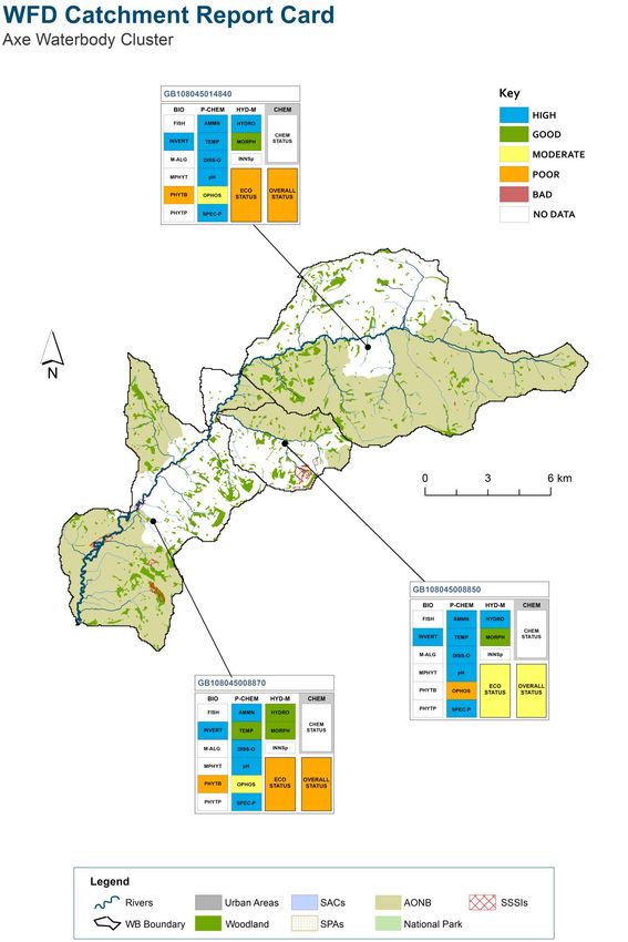
Contents
Introduction

Background and Partnership

Action plan

Outputs

Outcomes

Dissemination of information

Management plan
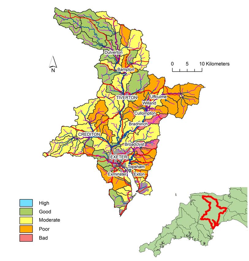
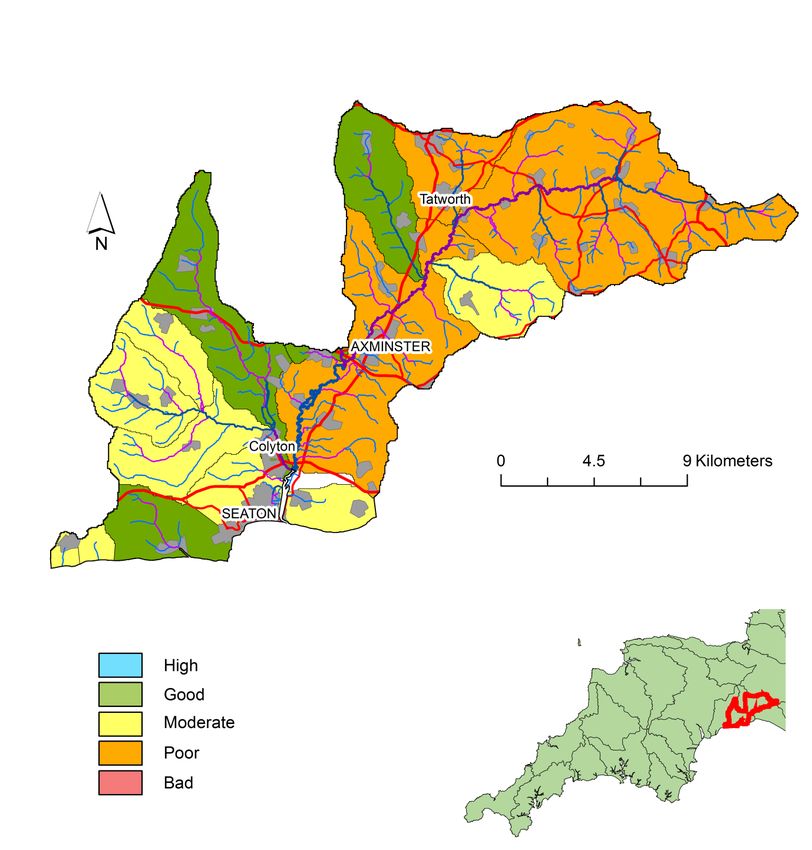
Introduction
Agriculture covers the majority of both of the catchments, which range from extensively managed
moorland, such as found on Exmoor, to intensive arable farming around Exeter (see figure 1). Whilst
the Axe, is an important grass growing area, specialising in dairy farming (see figure 2).

Figure 1. Map of the River Exe with WFD compliance.
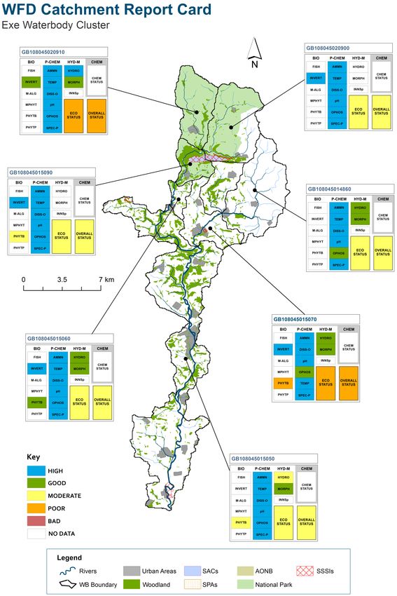
Figure 2. Map of the River Axe (excluding the Yarty) and the compliance with WFD.
River Exe Characteristics

The River Exe catchment covers a large area (1,530 km2) and drains a diverse
range of habitats from the moorland and mires of the Exmoor National Park where
the river rises, to the lowland floodplains and the City of Exeter where it flows into the
Exe Estuary. The River Exe rises at a level of 450 m AOD on Exmoor and descends
87.7 km to its tidal limit with an average gradient of 5.2 m/km. The River Culm rises
at 280m AOD on the Blackdown Hills. It descends 45.3 km along an average
gradient of 5.1m/km to its confluence with the River Exe at Stoke Cannon.

The River Exe catchment extends across several different landscape types. The
Rivers Exe and Barle rise in ‘The Chains’ in the wet open moorland of Exmoor,
before running south-eastward through a steep sided valley with extensive ancient
semi-natural oak woodlands. Further east, smaller tributaries run-off the Brendon
Hills, with the river Haddeo dammed in the mid 1970’s to create Wimbleball
Reservoir. Much of the Exmoor landscape has been modified by man, with
extensive enclosure and agricultural improvement taking place in the 19th Century,
giving it a softer, less rugged, appearance than Dartmoor.

Below Dulverton there is a transition where the River Barle joins the River Exe.
From here the Exe and its tributaries cut through the Culm Measures creating valleys
with rounded ridges between. The floodplain starts to widen out and there are
meadows alongside the river on the valley floor. Reaching Tiverton marks another
change, this time to the important rich farmland of the Devon Redland, which
extends to the coast and includes the valleys of the larger tributaries of the River Exe
like the Creedy and the Culm.

The headwaters of the River Exe lie on Middle and Upper Devonian rocks. The rock
strata are a complex sequence of slates, siltstones, thin limestones and sandstones.
These rocks act as a minor aquifer, usually yielding only sufficient water to meet the
private domestic requirements, however, they provide essential support to the
baseflow of the upper reaches of the river Exe, Barle and Batherm during extended
low flows.

The average annual rainfall for the catchment is 1,097mm which is higher than the
national mean (908mm). However it ranges from 772mm on the eastern side of the
catchment to 2,108 mm on Exmoor. The maximum daily mean flow of 286.95
cumecs and the maximum instantaneous flow of 492.56 m3/s were both recorded on
the 4th December 1960 at Thorverton resulting in significant flooding of Exeter and
Tiverton, emphasizing the need for flood alleviation schemes, which were
subsequently built in the 1970’s.

As in the majority of river catchments in Devon, the River Exe catchment is of great
importance for nature conservation. Indeed it contains some of the finest sites in the
South West. The Exe Estuary and surrounding land are designated as a Special
Protection Area (SPA) under the EC Birds Directive and as a wetland of International
Importance, especially as a waterfowl habitat, under the terms of the RAMSAR
Convention.

Twenty-seven sites are also designated Sites of Special Scientific Interest (SSSI)
including a number of river and wetland sites. In particular, the River Barle (SSSI) is
considered to be the best English example of a river which has an acidic upland
character grading into a rich sandstone type.

River Axe Characteristics

The river Axe rises near Cheddington in Dorset and is joined by several tributaries
before discharging into the sea at Seaton approximately 44km from its source. The
river drains a catchment area of 426 km2 and has a fairly shallow gradient of 4.3
m/km.

The Yarty is the principal tributary of the Axe. Rising near Staple Hill in Somerset it
flows south for approximately 24km, where it is joined by the Corry Brook, before
meeting the Axe at its junction 1km south-west of Axminster. The Yarty is much
steeper than the River Axe with an average gradient of 8.5 m/km.

The Axe catchment is underlain by rocks dating from the Triassic through to the
Cretaceous Periods. Most of the major river valleys have associated deposits of
river gravels and alluvium, whilst the slopes in the catchment are mainly covered by
brown earth soils. Land surrounding the main river channel and some tributaries is
typically fine loamy soil, slowly permeable and subject to seasonal waterlogging.
Pockets of slowly permeable clayey soils may also be found over the mudstone.

The Axe is a fairly rural catchment being mainly agricultural in nature, with some light
industry limited to the three main urban areas around Chard, Axminster and Seaton.
There is considerable variation in the rainfall across the catchment, from the wet high
grounds of the Blackdown Hills and the North Dorset downs to the more sheltered
lowland areas of the Axe estuary. Average annual rainfall varies with altitude, from
820mm along the coast to over 1,067mm on high ground.

Virtually the entire catchment falls within designated landscape areas, with three
large sections being recognised as being of national importance. These are the
Dorest, Blackdown and East Devon Areas of Outstanding Natural Beauty (AONB’s).
The coastal section of the catchment contains some of the region’s most spectacular
sites with its recent attainment of World Heritage Site Status to recognise, in
particular, the geological importance of the Dorset and East Devon coastline.
Background & Partnership
The main stem of the Axe flows through an almost unbroken agricultural landscape
from its source to the sea. From its junction with the river Blackwater, for the 13km
to the Estuary, the river Axe is designated a Site of Special Scientific Interest (SSSI),
this section is also designated as a Special Area of Conservation (SAC) under the
EC Habitats Directive. The River Axe was designated as a SAC as it contains
particular species of water crowfoot (ranunculus spp.) and water-starwort (Callitriche
spp.). This vegetation typically grows in small, lowland rivers on chalk/limestone
geology. The growth of these plant species can be adversely affected by siltation
and trampling by livestock. Important fish, including Atlantic salmon, bullhead and
lamprey are also found in the Axe. Likewise the spawning success of fish can also
be affected by fine sediment clogging potential spawning gravels, with barriers to
migration, such as weirs also limiting the populations within the river.

The decline in habitat and water quality of the River Axe has become of increasing
concern in recent years. The river Axe currently fails to meet good ecological status
for most of its length, with the problem of diffuse pollution, unrestricted livestock
access to the river and soil and riverbank erosion being widespread. These issues
are particularly widespread along the Axe SSSI/SAC with the SSSI failing to achieve
favourable condition on most recent assessment by Natural England, as a result of
siltation and diffuse pollution amongst other issues.

Following on from the Axe Valley and Cycleau Projects, Catchment Sensitive
Farming (CSF) has been working closely with farmers to directly tackle these issues.
Most of the upper and main river Axe is currently a priority area for targeting CSF
advice and grant funding. The Axe and Exe River Improvement Project (AERIP) will
therefore concentrate its targeted farm advisory work outside of this area, on another
failing tributary, the River Blackwater. Whilst work to improve fish passage, will
target weirs in the upper main stem to improve the access to the headwaters.

In order to help the Rivers Axe and Exe and their tributaries meet and pass WFD
good ecological status. A wide ranging project partnership must pull together with all
the other local stakeholders involved from across the respective catchments to
address the significant issues and pressures that the catchments are under. This
will range from South West Water, with Wimbleball, its strategic water supply
reservoir on Exmoor; to the significant number of individual landowners and farmers
that partake in agriculture, the primary industry across most of these rural
catchments. There is a well established network of parties that are interested in
working together to ensure that the rivers are protected and enhanced; from the very
active riparian interests to the government agencies with important overseeing
regulatory roles.
Figure 3. River Axe Map with selected Waterbody ID’s.
With its source high on Exmoor, linked to its extensive moorland farming, the River
Exe is fortunate to have higher quality water and riverine habitat within the Exmoor
National Parks protected landscape. It was probably not coincidental that with high
rainfall and steep valleys that a site on Exmoor was chosen for a significant water
supply reservoir. However, this has brought the associated tributaries of the Haddeo
and Pulham their own unique set of problems linked to regulated flows and heavy
modification. Further down the catchment as the soils become more productive, the
intensity of farming increases, as do the threats to water quality. It is probably
therefore no surprise to find the most significant problems located with the Crediton
Red Soils stretching across the Culm and Creedy River Valleys.

There are historically significant partnerships already established across the
catchments; with the Environment Agency working closely with the Axe riparian
interests to restock salmon sourced from the river Exe after the complete collapse in
the River Axe salmon population from the late 1990’s. All riparian groups are keen
to work together to see improvements and share knowledge as seen with the
Westcountry Hatchery Forum. Through this joint working with the active Riparian
Associations and the WRT, the Environment Agency has particularly good working
relationships with the riparian interests helping to steer sustainable improvements.
Together significant catchment management approaches are being developed; here
the Environment Agency and the River Exe and Tributaries Association (RETA) are
a particularly good example for partnership delivery of catchment actions.

Work through the AERIP will be guided to help tackle the problems of siltation and
poor fish access, particularly in the Culm. Here, stocking will be an important
component to help kick start the recovery of the salmon population whilst the longer-
term water quality improvements from the work of CSF are seen. Likewise, whilst
the AERIP tackles the problem of modified flows and a shortage of good quality of
spawning gravel in the Haddeo, stocking will be an important aspect of the work both
with RETA and with the local schools, with River Exe Salmon being hatched from
ova in their own Classrooms, before release to their local rivers.
Figure 4. River Exe Map with selected Waterbody ID’s.
Table 1: Axe and Exe water-body WFD status
WB Name Exe Exe Exe Batherm Batherm Haddeo Haddeo Pulham Culm Culm Culm Axe Axe Blackwater
WB ID 9040 15050 15060 15070 14860 15090 20900 20910 14970 15000 14980 14840 8870 8850
Overall Status Moderate Moderate Moderate Poor Moderate Moderate Moderate Poor Moderate Poor Poor Poor Poor Moderate
Ecological
Moderate Moderate Moderate Poor Moderate Moderate Moderate Poor Moderate Poor Poor Poor Poor Moderate
Status
Chemical
Good Good X X X X X X Good X X X Good X
Status
Biological
Fish High X Moderate Moderate Moderate Moderate Good Poor X Moderate Poor Good X Good
Invertebrates X High High High X High High Good Good High Good High High High
Macroalgae X X X X X X X X X X X X X X
Macrophytes X Good High High X Good X X X Moderate X Moderate Moderate X
Phytobenthos Moderate Moderate Good Poor X Moderate X X X Poor X Poor Poor X
Phytoplankton X X X X X X X X X X X X X X
Physio-Chem
Ammonia High High High High High High High High High Moderate High High High High
Dissolved
Good High High High High High High High High High High High High High
Oxygen
pH High High High High High High High High High High High High High High
Phosphate Good High High Good Good High High High Moderate Moderate Good Moderate Moderate Poor
Temperature High High High High High High High High Good High Good High Good High
Specific
High High High High High High High High High Moderate High High High High
Pollutants
Hydro-
morphology
Hydrology Not High Moderate Not High Not High Not High X X High Not High High Not High High Not High High
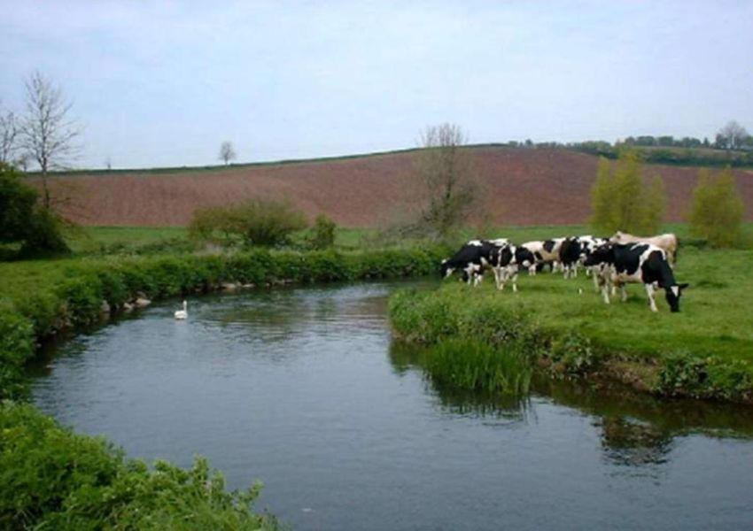
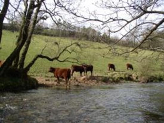
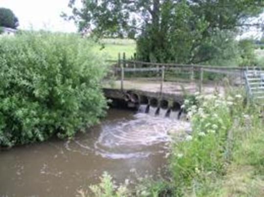
Morphology X Good Good Good Good X X Good Good Good Good Good Good GoodAction Plan The Axe and Exe River Improvement Project will aim to tackle the key issues that are affecting the ecological and chemical status of rivers and improve the WFD status. It will work with the key local partners like RETA, Axe Vale Rivers Association, farmers, landowners, National Park, AONBs and the Environment Agency and will aim to employ a full time member of staff for 3 years in order to deliver the project. Where WFD water bodies are failing for fish, targeted fisheries work will be conducted including the improvement of degraded habitat to encourage fish populations, particularly in the improvement to riparian areas that lack suitable cover for fish, such as where they have been degraded by unrestricted cattle access. The introduction of spawning gravels will also help improve the recruitment of local fish stocks, particularly where there is a known deficiency, such as below Wimbleball Reservoir. Information from the WIPS and from the local Environment Agency Team have all been used to guide these actions, particularly as far as sediment and nutrient transfer are concerned, which will be key in tributaries such as the Blackwater on the Axe and the Batherm on the Exe. Here agricultural/diffuse pollution issues within a catchment and failures for phosphate or phytobenthos, will also be targeted with agricultural best practice advice alongside soil testing. Demonstration events of best practice will be organised for groups of farmers in each catchment. Farmers will have the loan of a soil aerator to clearly understand the benefits of removing surface compaction, to help reduce run- off and thereby maximise the productivity of pastures through the efficient utilisation of manures and fertiliser. As well as fencing, alternative drinking supplies will be encouraged to reduce the intrusion of livestock and associated soil input to watercourses. Figure 5. Photograph above left of cattle causing damage to banks when drinking from River Exe. Figure 6. Photograph above right of an Irish Pipe Bridge River Axe, Manor Farm, Seaborough. Where fish failures and specific issues such as weirs are preventing fish migration these will also be tackled. Direct improvements to weirs with the installation of fish passes will be undertaken, thereby ensuring good access to the spawning grounds upstream.
Outputs
  We aim to assist the Environment Agency in delivering a GES (Good Ecological Status) for fish and other biological failures by 2015.

  Each activity is designed according to best practices described in the Environment Agencies River Restoration Handbook and the Guidance manuals of the
  River Restoration Centre. However the Westcountry Rivers Trust has extensive experience in land and river management and has co-authored several
  Environment Agency guides including the Management of Woody Debris, Strategic Bankside Coppicing and the management of Riparian Woody
  Debris. Additionally WRT authored the Best Farming Practice Guidance notes currently used by the Catchment Sensitive Farming Initiative and the Trust is
  contracted by CSF and DEFRA nationally to train Farm Advisors for delivery of Integrated Farm Advice.

  The table below gives proposed projects for delivery within the catchments. The table is a complete list of activities which we feel will help meet WFD good
  status by 2015, but this does not preclude additional activity which we will try to encourage in partnership with local stakeholders to meet other objectives
  of priority areas (DWI) (Habitats and Species)

  Table 2: Outlines water-body, failure and proposed action

Waterbody ID      Name          Failure           Action

GB108045020900    Haddeo        Fish              Electrofishing survey- to determine fish abundance pre and post works
GB108045015090                  (Moderate)
                                                  Habitat creation-
                                Photobenthos      1 km Selective coppicing and introduction of Large Woody Debris (25 stems)
                                (Moderate)
                                                  Gravel Augmentation – 15 sites to have gravel introduced to create improved spawning areas.
                                                  Gravel Loosening – 15 sites to have gravels loosened mechanically.
                                                  Gravel Washing – 10 sites to have gravels washed by water powered pump.

                                                  Sediment Traps/Diverters – Implement 4 sediment traps/diverters to prevent direct run-off from forestry
                                                  tracks to the river.
River FISH (POOR) Habitat creation- 1km Selective coppicing and introduction of Large Woody Debris (25 stems) to provide
GB108045020910 Pulham instream cover for fish and habitat for invertebrates.
Fencing – 1 km river.
Sediment Traps/Diverters – Implement 4 sediment traps/diverters to prevent direct run-off from forestry
tracks to the river.
Electrofishing survey- to determine fish abundance pre and post works
Work with South West Water- Potential improvements Brompton Regis STW.
GB108045014860 River Fish Habitat creation-
GB108045015070 Batherm (Moderate) 2km Selective coppicing and introduction of Large Woody Debris (50 stems)
Fencing - 2km of fencing and installation of alternate drinking to reduce intrusion of livestock and bank side
Phytobenthos erosion.
(Poor)
Nutrient management- 25 soil tests per year to be made available to farmers in the catchment.
Farm demonstration – Workshops and loan of aerator to reduce run-off
Electrofishing survey- to determine fish abundance pre and post works
GB108045009040 River Exe Fish Weir easement- Improve migratory fish passage for the main river and tributaries upstream
GB108045015050 (Moderate) Works at Pynes (SX 917 626), Exwick (SX 905 505) and Cowley (SX 908 537) weirs to improve fish passage
GB108045015060 Phytobenthos will all greatly benefit upstream reaches.
(Moderate)
1km Selective coppicing and introduction of Large Woody Debris (25 stems)
Improvements in water quality from upstream reaches will benefit the phytobenthos in these main river
sections.GB108045014970 River Culm Fish Weir Easement –Improve migratory fish passage at Uffculme (ST 065122) and Whitehall (ST 127138) weirs.
GB108045015000 (Moderate)
GB108045014980 Fish (Poor) Habitat improvement – 1km Selective coppicing and Introduction of Large Woody Debris (25 stems).
Phytobenthos
(Poor) Electrofishing survey- to determine fish abundance pre and post works
GB108045008850 Blackwater Phosphate Electrofishing survey- to determine fish abundance pre and post works
(Poor)*
Fencing - 2km of fencing and installation of alternate drinking to reduce intrusion of livestock and bank side
erosion.
Farm demonstration – Workshops and loan of aerator to reduce run-off.
Stock management - Provision of cattle tracks to reduce sedimentation.
Nutrient management- 25 soil tests per year to be made available to farmers in the catchment.
GB108045014840 Axe Phytobenthos Weir Easement –Improve migratory fish passage at Clapton weir and at Manor Farm, Seaborough.
GB108045008870 (Poor)
Improved access for salmonids to the headwaters of the River Axe.Table 3 – Gantt chart showing timings of actions for the Axe and Exe RIP.
Q1 runs from May to July, Q2 from August to October and so on.
AERIP 2012 2013 2014
TASK Q1 Q2 Q3 Q4 Q1 Q2 Q3 Q4 Q1 Q2 Q3 Q4
1 - Review
Desk study (data collation) 1
Annual review (report) 1 1 1
Additional monitoring (sites) 40 40 40 40*
2 - Restore
Fencing (km) 1 1 1 1 1 1
Cattle Troughs 1 1 1
Coppicing (km) 2 2 2
Large Woody Debris Intro(Sites) 25 25 25 25 25 25
Gravel cleaning (sites) 10 10 10
Gravel augmentation (sites) 15 15 15
Cattle Tracks 2 2 2
Sediment Diverters/Traps 2 2 2 2
Fish Passes 2 2 3
3 - Restock
Restocking locations (sites) 10 10 10
4 - Re-engage
Salmon in the classroom 4 4 4
Soil Testing with farmers 10 10 10
Community events 1 1 1 1 1 1 1 1 1 1 1 1
Partnership meetings 1 1 1 1 1 1
* RETA to provide some funding to undertake the final electrofishing monitoring in summer 2015Outcomes The implementation of these works will help to address WFD failures in the region and also tackle local issues to individual rivers and catchments. There will also be significant ecosystem service benefits such as an improvement in raw water quality, which will help the Environment Agency meet objectives under the bathing water quality directive. By working with individual landowners across a catchment there is scope for significant catchment scale improvements through targeted improvement works. The reduction in bankside erosion will reduce tonnes of soil being eroded and will act as a buffer against nutrient and agro-chemicals from fields. The advice provided to farmers will also help them become more aware of the impacts they are having and reach a practical and economic solution. The completion of walkover surveys will provide current and future conservationists with a valuable resource which will also allow future work to be targeted and may highlight new issues that require attention. Electrofishing surveys and hydro-geomorphological assessment pre and post work will also allow us to assess work improvements and provide a baseline against which further improvements can be made. The work has been targeted using local knowledge and that gained from the Waterbody Implementation Plans to help directly improve the ecological status of rivers. The Westcountry Rivers Trust also has extensive experience (15+ years) of delivering such projects, having a wide remit that currently covers large agricultural improvement projects such as Upstream Thinking which is a £2.9m project in partnership with South West Water. There are also pan European fisheries research projects including AARC Project and work that that’s has been undertaken through the River Improvement Fund through DEFRA.
Summary Impact appraisal
  Table 4. Adapted after the Millennium Ecosystem Assessment and details the estimated delivery in other
                  ecosystem services during the Axe and Exe River Improvement Project

                                       Estimated
        Ecosystem Service                                                            Notes
                                        change
Provisioning services
Fresh water                               ++       Purification of water by increased retention of sediment by buffers
Food (e.g. crops, fruit, fish, etc.)       -       Potential loss of grazing counteracted by improved management
Fibre and fuel (e.g. timber, etc.)        +        Coppicing opportunities for domestic use
Genetic resources                         0        Small increase or neutral
Biochemicals, natural medicines,          0        Small increase or neutral
Ornamental resources (e.g.
                                           ?       Not known
shells)
Regulatory services
Air quality regulation                    0        Small increase or neutral
Climate regulation
                                          +        Net increase in greenhouse gas sequestration with small scale habitat shift
(sequestration)
Water regulation (flooding, etc.)         +        Net increase in water storage with slowing flows
Natural hazard reg. (i.e. storms)         +        Valued in water regulation
Pest regulation                            ?       Not known
Disease regulation                         ?       Not known
Erosion regulation                        ++       Reduced erosion through improvement in bank stability
Water purification & treat waste          +        Valued in fresh water provision
Pollination                               0        Small increase or neutral
Cultural services
Cultural heritage                         ++       Increase in cultural knowlegde about fishing, farming and the river
Recreation and tourism                    ++       Improved direct fishing but also downstream bathing water
Aesthetic value                           0        Valued in recreation
Spiritual and religious value              ?       Not known
Inspiration of art, folklore, etc         0        Valued in culture
Social relations                          0        Valued in culture
Supporting services
Soil formation                            +        Valued in erosion regulation and fresh water provision
Primary production                        +        Quantification complex
Nutrient cycling                          +        Valued in Climate regulation and fresh water provision
Water recycling                           +        Valued in fresh water provision
Photosynthesis                            +        Quantification complex
Provision of habitat                      ++       Net increase in diverse habitat
Dissemination of information Large sections of the River Axe and Exe have open access and are visited, walked and cycled by thousands of people each year. Therefore there is an excellent opportunity to educate and engage with the local community as well as significant numbers of tourists that visit East Devon and Exmoor. As the value of the Axe and Exe increases both ecologically and as unique fisheries, there will be an increased number of people who will wish to visit, maintain and continue to restore them. Throughout the course of the project there will be knowledge transfer between all collaborative partners. Each partner will benefit from the other’s experience, whether it be local knowledge, project management experience, or innovative approaches to a particular problem. Electrofishing data and that from any other surveys, including those for invasive species will be made available to project partners including the Environment Agency who may use it to target works or use as evidence to demonstrate improvements over time. Management Plan WRT is an environmental charity (Charity No: 1135007) established in 1994 to secure the preservation, protection, development and improvement of the rivers, streams, watercourses and water impoundments in the Westcountry and to advance the education of the public in the management of water and water related activities. The Trust’s vision is to have living, working landscapes that deliver employment, food and amenity without negatively impacting biodiversity or raw water quality. We feel this can be achieved without heavy regulation and supervision by educating people about their place in the water cycle and its importance to their life. The river is the report card for how sustainably we live on the land. To achieve its aims the Trust has won and led numerous projects ranging in scale from tens of thousands to multimillion-pound national and international projects. The Trust has delivered projects using National Structural Funds including Objective 5B, Objective 1 and most WRT are jointly leading the RDPE funded Country Sports and Tourism Project which is one of six selected to improve tourism in the region. The Trust has also delivered several major engineering projects in recent years installing fish passes and removing weirs. Internationally WRT have led the Atlantic Salmon Arc Project (1 and 2) using European Interreg 3B funding for the Atlantic Area worth nearly £2 million over 5 years. WRT are currently leading the AARC project in partnership with 9 other EU universities and public authorities across 5 Member States which is worth nearly £3 million over three years (EA are an Associate Partner). WRT are also leading the Interreg IVB, North West Area, WATER project worth nearly £3.5 over three years in collaboration with UK and French partners including the Environment Agency. WRT have also been partners in several EU projects focussed on controlling Invasive Weeds, delivering Farm Management advice; compiling Eel Management plans for the region and undertaking primary research. WRT have been through rigorous financial and delivery audits undertaken by DEFRA or international EU Audit teams and have to date had not significant issues.
In summary WRT has all of the skills required to run and deliver the proposed projects. The Trust
structure and staffing is included below:

The project will be led by a WRT based project coordinator in charge of overall project management
and delivery. The project coordinator will work alongside a project accountant within WRT to ensure
good governance, record keeping and financial acuity. The project coordinator will invite supporting
partners to sit on a project steering group, which will meet at six-month intervals to review progress
and integration. The project coordinator will report to existing partnership groups in the area to
ensure maximum integration of the work with existing plans and partnerships.

The project accountant will compile quarterly claims for eligible costs and the Finance Director Lynne
Hyland (ACCA) will sign off each claim. Accounts will be audited annually by an external auditor.
You can also read