BASIC GUIDE TO NAUTICAL SERVICES IN GALICIA
←
→
Page content transcription
If your browser does not render page correctly, please read the page content below
www.portosdegalicia.com
www.guianauticadegalicia.com
www.nauticdestination.com

      porto único

                         BASIC GUIDE TO NAUTICAL
                             SERVICES IN GALICIA
                               Includes new coastal routes through
                                          the Rias Bajas estuaries

                     GUIDE BASIQUE DES SERVICES
                            NAUTIQUES DE GALICE
                                Inclut de nouvelles routes côtières
                                               par les Rías Baixas
BASIC GUIDE TO NAUTICAL
   SERVICES IN GALICIA
 Includes new coastal routes through
       the Rias Bajas estuaries

GUIDE BASIQUE DES SERVICES
   NAUTIQUES DE GALICE
  Inclut de nouvelles routes côtières
          par les Rías Baixas
CONTENTS
www.portosdegalicia.com TABLE DES MATIÈRES
ORTIGUEIRA
VIVEIRO
RIBADEO
FERROL 14 12
10
16 18 20
ARES 22
A CORUÑA 28 30 24 26 SADA
32 34
36
BASIC GUIDE TO NAUTICAL SERVICES IN GALICIA CAMARIÑAS
GUIDE BASIQUE DES SERVICES NAUTIQUES DE GALICE
38
MUXÍA 40
Management:
Direction:
- Valentín Domínguez Fernández
Work team:
CABO DE CRUZ
Équipe de travail:
MUROS 44
- Julio Hernández Sanmamed - AP de Ferrol-San Cibrao 62 PADRÓN I PONTECESURES I VALGA
PORTOSÍN 46 60 RIANXO
- Sebastián García Orro - AP de A Coruña
A POBRA 56
58 64 VILAGARCÍA DE AROUSA
- Alfonso R. González Gallego - AP de Vilagarcía de Arousa 66 VILANOVA DE AROUSA
- Manuel García Rodiño - AP de Marín y Ría de Pontevedra
RIBEIRA 54
LA TOJA 68 COMBARRO
- Beatriz Colunga Fidalgo - AP de Vigo PEDRAS NEGRAS 76
- Valentín Domínguez Fernández - Ente público Portos de Galicia PORTONOVO 78 84 86
PONTEVEDRA
SANXENXO 80 82 88
MARÍN
Acknowledgements:
BELUSO I BUEU 90 100 MOAÑA
CANGAS 98 102 CESANTES
Remerciements:
- Asociación de Clubs Náuticos de Galicia (ASNAUGA) VIGO 104 106 108 110
- Instituto Hidrográfico de la Marina (IHM)
BAIONA 112 114
- Masmar. www.masmar.com 116
- Aos Clubes Náuticos e concesionarios, pola súa colaboración
TUI
Design, layout and printing:
Conception, mise en page et impression:
GRÁFICAS SALNÉS S.L.
The information in this guide is for informational purposes only and not suitable for use in navigation. 0217_ecodestin_3IN_1_E
Les informations figurant dans ce guide sont fournies uniquement à titre d’information et ne sauraient être utilisées
www.ecodestin.com
pour la navigation.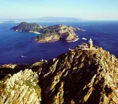
project ecodestin projet ecodestin
Santiago
de Compostela
Project ECODESTIN_3IN, which is part of Le projet ECODESTIN_3IN, faisant partie du
the Spain-Portugal INTERREG V-A 2014- Programme INTERREG V-A Espagne-Por-
2020 (Poctep) Program, aims to boost tugal 2014-2020 (Poctep), cherche à faire
AP-9 tourist interest in the region through the augmenter l’attrait du territoire par la pro-
promotion and development of the natu- motion et le développement du patrimoine
Padrón ral and cultural heritage linked to the rías naturel et culturel lié aux rías, aux rivières
(estuaries), rivers and coast of the Gali- et à la côte de l’Eurorégion Galice-Nord du
Pontecesures
cia-North Portugal Euroregion. Portugal.
Valga
Cabo
la
The main objectives of Project ECODES- Quelques-unes des principales cibles spé-
Ul
de Cruz Rianxo
o
(Boiro)
Rí
TIN_3IN are specified as follows: cifiques du projet ECODESTIN_3IN sont :
A Pobra do sa Isla de
ou Cortegada
Caramiñal
e Ar
ad Vilagarcía • Increase the Euroregion’s attractions by • L’élargissement de l’attrait de l’Eurorégion
Dunas de Rí de Arousa
Corrubedo Vilanova focussing on the natural and cultural her- par la mise en valeur du patrimoine naturel
de Arousa
Ribeira
A Illa de AP-9 itage found in the rivers, rías and coasts et culturel des rivières, des rías et des côtes
Arousa
to make the area an integrated and ac- pour transformer le territoire et une desti-
Ribadumia
A Toxa Cambados cessible destination open to intelligent, nation accessible, intégrée, intelligente et
international tourism based on a strategy internationale, sous la stratégie de la qua-
O Grove
Isla de that values quality and sustainability. lité et de la durabilité.
Sálvora
San Vicente Combarro
do Mar (Poio)
• The creation of new options for tourists • La création de nouvelles offres pour pro-
Pontevedra
Sanxenxo to enjoy a unique experience by explor- fiter d’une expérience unique afin de faire
ra
ed
t ev ing the Euroregions’s natural and cultural connaitre l’Eurorégion d’une manière na-
n Marín
Islas Ons Po
de heritage. Among these new possibilities turelle et culturelle, où seraient comprises
Portonovo a
Rí
are the Mini Coastal Cruises which offer a les Mini-croisières côtières, consistant en
Bueu Soutomaior
AP-9 number of different short sailing itinerar- une série d’itinéraires de navigation de
Isla de San Simón ies (ranging from 1 to 6 days) on the Rías courte durée (de 1 à 6 jours) le long des
* Puerto de embarque Redondela Baixas. The cruises also include stops to Rías Baixas, tout en reliant ces routes à des
Aeropuerto
Cangas o visit tourist attractions related to the re- secteurs d’attraction touristique tels que la
e Vig Rande
Estación de Tren
Ríad gion’s culture, heritage and oenology. culture, le patrimoine et l’œnologie. Il s’agit
Camino de Santiago* Islas Cíes The aim is to offer new and different pos- de créer une offre touristique différente et
Vigo
Villa Marinera sibilities all year round. This guide pre- désaisonnalisée. Ce guide vous présente
Villa Histórica
sents several mini cruise options on the plusieurs propositions de mini-croisières à
Rias Baixas. travers les Rías Baixas.
Parque Nacional
Monumento Natural
IT INCLUDES NEW COASTAL ROUTES INCLUT DE NOUVELLES ROUTES CÔ-
* Puntos de sellado Traslatio Xacobea Baiona
Oia ON THE RIAS BAIXAS TIÈRES PAR LES RIAS BAIXAS
4 5
TREASURES OF GALICIAN ESTUARIES                                                                                 MARITIME-TERRESTRIAL
                                                                                                                NATIONAL PARK OF THE
                                                                                                                    ATLANTIC ISLANDS
Galician estuaries are one of the marine            Viveiro, Ría de Foz and Ría de Ribadeo,
ecosystems of more biological diversity             and occupy the North and northwest of                Belonging to the European Network Natura,
in the planet, and constitute one of the            the province of A Coruña and the entire              is one of the largest natural treasures of the
peculiarities of the geography of Galicia.          coast of Lugo, limiting with Asturias to the         Galician estuaries and includes archipelagos
These long arms of sea that penetrate in            east and with the cape of Finisterre to the          Cies, Ons, Sálvora and Cortegada. This set of
the land, define the landscape and the              south. They are much younger - they are              islands and islets, with an area of 8,333 hec-
idiosyncrasy of Galicia, which it treasures         only 24 million years old. Its beaches are           tares (of which more than 7,200 hectares are
along its 1,498 kilometers of coast, more           open and brave, exposed to the action of             marine surface), constitutes a natural barrier
than 700 beaches nestled in wonderful               the sea.                                             that makes the Rías Baixas a safe space to
natural landscapes and towns, with a                                                                     navigate and anchor during all year.
rich gastronomy and a millenary culture             Unlike a fjord, which is deep and
always linked to the sea. The Estuaries             steepslopes caused by a glacier, an                  The best known archipelago is Cies, formed
“Rías” owe their name to the geographer             estuary designates a valley of a coastal river       by three Islands: Monte Agudo, O Faro and
and geologist German Ferdinand von                  flooded by sea level rise. But the Galician          San Martiño, located only 14 kilometers away
Richthofen, uncle of the famous Red                 are not the same as the rest of the world.           from Port of Vigo. In this island are represen-
Baron, that baptized them in such a way             This is due to the coastal outcrop, which            ted all the natural ecosystems linked to both
in 1886, during the trip that made around           occurs in spring and summer because                  coastal zones and continental platfomrs of
of the world to study the different types           of the north winds, that move offshore               the Eurasian region. Here the yellow- legged
of coast. The determining factor of the             the surface waters of the estuary, and               gull has its largest European colony. Its nine
formation of the Galician estuaries was the         replace it with the deeper, more nutrient-           beaches conquer the visitor with their white
rise of the sea as a result of the melting of       rich and colder, which explains the high             sands and their wild condition, as well as it
the water of the poles.                             productivity and quality of its seafood.             can be traversed through hiking trails.

Traditionally, the sixteen Galician estuaries       Protected from the huge oceanic storms               The best known is the Rhodes one, the best
are divided into Rías Baixas and Rías Altas,        by the islands that emerge from its                  beach in the world according to “The Guar-
according to their position regarding               waters, the estuaries allow safe navigation          dian.” It is allowed to camp by reserving one
Fisterra as the westernmost point of                almost all the year. This security is what           of its 800 places of campsite. One of the
Galicia. The Rías Baixas are six: Ría de            encouraged Austria’s Innsbruck (Austria)             most experience you can enjoy in the Vigo
Concurbión, Ría de Muros and Noia, Ría              Cup America’s Cup to establish its base in           estuary is to dive between lobsters, crabs
de Arousa, Ría de Pontevedra, Ría de                Sanxenxo, one of the ports of the Ría de             and octopus. In addition, the Cíes have the
Aldán and Ría de Vigo, and occupy the               Pontevedra.                                          seal”Starlight” that accredit them as a tourist
west coast of the province of A Coruña                                                                   destination of interest for the observation of
and almost all the coast of Pontevedra,             The weather in Galicia is oceanic,                   stars.
from Cape Fisterra to the estuary of Vigo.          characterized by the regularity of
These are the oldest- formed 110 million            precipitation and mild temperatures                                    +Info:www.illasatlanticas.es
years ago - and create smooth sands that            (between 7º and 24º degree Celsius),
invite to the tranquility. The Rías Altas are       although there are differences between
ten: Ría do Burgo or Ría de A Coruña, Ría           the coastal and inland areas, as well as
de Betanzos, Ría de Ares, Ría de Ferrol, Ría        North and south. Thus, the Rías Altas have
de Cerdeira, Ría de Ortigueira, Ria de Ares         a maritime-type climate, while the south is
and Betanzos, Ria de O Barqueiro, Ría de            a subtropical zone.

                                                6                                                    7
TRÉSORS DES RIAS DE GALICE                                                                                                         PARC NATIONAL
                                                                                                                             MARITIME-TERRESTRE
                                                                                                                            DES ILES ATLANTIQUES
Les Rias de Galice constituent l’un des éco-            Ria de Ribadeo, qui occupent la partie nord
systèmes marins de plus grande diversité                et nord-ouest de la province de La Corogne               Appartenant au Réseau Européen Natura, est
biologique de la planète, et l’une des par-             et toute la côte de Lugo, limitant avec les              l’un des plus grands trésors naturels des rias
ticularités de la géographie de la Galice.              Asturies à l’est et avec le cap de Finistère au          galiciennes et comprend les archipels Cíes,
Ses longs bras de mer qui pénètre dans les              sud. Elles sont beaucoup plus jeunes -seu-               Ons, Sálvora et Cortegada. Cet ensemble
terres, définirent le paysage et l’idiosyncra-          lement 24 millions d’années - et ses plages              d’îles et d’îlots, d’une extension de 8.333 hec-
sie de la Galice qui, le long de ses 1.498 ki-          sont ouvertes et sauvages, exposées à l’ac-              tares (incluant plus de 7.200 de surface ma-
lomètres de côte, réunit plus de 700 plages             tion de mer.                                             rine), constitue une barrière naturelle qui fait
enclavées en en de merveilleux parages                                                                           des Rias Baixas un espace sûr pour naviguer
naturels et villages, avec une riche gastro-            À la différence d’un fjord, qui est profond              et mouiller pendant toute l’année.
nomie et une culture millénaire toujours liée           et aux versants escarpés provoqués par
à la mer. Les rias doivent son nom au géo-              un glacier, une ria désigne la vallée d’une              L’archipel le plus connu est celui des Cíes, for-
graphe et géologue allemand Ferdinand                   rivière côtière inondée par l’élévation du ni-           mé par trois îles: Monte Agudo, O Faro et San
Von Richthofen, oncle du fameux Baron                   veau de la mer. Mais les rias de la Galice               Martiño, à seulement 14 kilomètres du port de
Rouge, que les a baptisées ainsi en 1886,               sont pas non plus égales à celles du reste               Vigo. Sur les îles Cíes sont représentés tous les
pendant le voyage qu’il a réalisé autour du             du monde. Ceci est dû à l’affleurement cô-               écosystèmes naturels liés aux zones côtières
monde pour étudier les divers types de côte.            tier, qui se produit au printemps et en été en           et aux plateformes continentales de la région
Le facteur déterminant de la formation de               raison des vents du nord, qui déplacent a la             eurasiatique. Le Goéland leucophée y trouve
les rias galiciennes a été l’augmentation du            mer de fond les eaux superficielles de la ria            sa plus grande colonie européenne. Ses neuf
niveau de la mer à la suite de la fusion de             et la substituent par les eaux profondes de              plages conquièrent le visiteur pour ses sables
l’eau des pôles.                                        l’Atlantique, plus froides et riches en subs-            blancs et son état sauvage, et l’on peut les
                                                        tances, et qui explique la grande producti-              parcourir à travers les routes de trekking.
Traditionnellement, les seize rias gali-                vité et la qualité de ses fruits de mer.
ciennes se divisent en Rias Baixas (basses)                                                                      La plus connue est celle de Rodas, la meil-
et Rias Altas (hautes), selon sa position par           Protégées des grandes tempêtes océa-                     leure plage du monde selon The Guardian.
rapport à Fisterra, le point le plus occiden-           niques par les îles qui émergent de ses                  Sur Les Cíes on permet camper en réservant
tal de la Galice. Il y a six Rias Baixas: Ria           eaux, les rias permettent la navigation sûre             un espace à son camping de 800 places.
de Concurbión, Ria de Muros et Noia, Ria                presque toute l’année. Cette sécurité est                Une expérience des plus stupéfiantes dont
d’Arousa, Ria de Pontevedra, Ria d’Aldán et             celle qui il motivé l’équipe de Innsbruck (Au-           on peut profiter à la ria de Vigo est la plon-
Ria de Vigo, qui occupent la côte ouest de              triche) de Voile de la Copa América à établir            gée sous-marine entre homards, crabes et
la province de La Corogne et presque tout               sa base à Sanxenxo, l’un des ports de la Ria             poulpes. De plus, Les Cíes ont le label Star-
le littoral de celle de Pontevedra, depuis le           de Pontevedra.                                           light qui les accréditent comme une desti-
Cap Fisterra jusqu’à la ria de Vigo. Ce sont                                                                     nation touristique d’intérêt pour l’observation
les plus anciennes -elles se sont formées               Le climat en Galice est océanique, caracté-              d’étoiles.
il y a 110 millions d’années- et créent de              risé par la régularité des précipitations et les
douces étendues de sable qui invitent à la              températures douces (entre 7º et 24º), bien                                 +Info:www.illasatlanticas.es
tranquillité. Il ya dix Rias Altas: Ria de o Bur-       qu’il existe des différences entre la zone lit-
go ou Ria de La Corogne, Ria de Betanzos,               torale et l’intérieur, et entre le nord et le sud.
Ria d’Ares, Ria de Ferrol, Ria de Cerdeira,             Ainsi, les Rias Altas ont un climat de tyri-
Ria d’Ortigueira, Ria d’Ares et Betanzos, Ria           time, alors que le sud est une zone de type
de o Barqueiro, Ria de Viveiro, Ria de Foz et           sous-tropical.

                                                    8                                                        9
LUGO                                       PORT OF/PORT DE RIBADEO                                                                  REAL CLUB NÁUTICO DE RIBADEO                                                              SERVICES
                                                                                                                                                                                                                                   SERVICES
NAUTICAL CHARTS/CARTES NAUTIQUES :
4071, 407 IHM
                                                                   Coordinates/Coordonnées : 43º 43’ 5’’, 7º 21’ 3’’             TRANSPORT ROUTES AND ACCESS
                                                                                                                                 Nearest airport: Alvedro (A Coruña) 137 km away, tel. +34 981 187 200. Lavacolla (San-
                                                                                                                                 tiago) 178 km away, tel. +34 981 547 501. Asturias 133 km away. We can reach this
                                                                                                                                 city via the N-634 road crossing the Los Santos Bridge or via the N-640 road from Lugo.
                                                                                                                                 Whoever decides to take the coastal train to the town should know that the train stops in
                                                                                                                                 Esteiro and Os Castros, besides the stations in Rinlo, Ribadeo and Vegadeo.
                                                                                                                                 Ribadeo station. FEVE tel. +34 982 128 689.

                                                                                                                                 COMMUNICATIONS ET ACCÈS
                                                                                                                                 Aéroport le plus proche : Alvedro (A Coruña) à 137 km, tél. +34 981 187 200. Lavacolla
                                                                                                                                 (Santiago) à 178 km, tél. +34 981 547 501. Asturias à 133 km. Pour accéder à ce village
                                                                                                                                 en voiture, emprunter la nationale N-634 traversant le pont de Los Santos ou la nationale
                                                                                                                                 N-640, en provenance Lugo. Pour s’y rendre en train, il existe des points d’arrêt du train
                                                                                                                                 de la côte à Esteiro et Os Castros, outre les gares de Rinlo, Ribadeo et Vegadeo.
                                                                                                                                 Gare ferroviaire de Ribadeo. FEVE tél. +34 982 128 689.

                                                                                                                                 TOURISM
                                                                                                                                 The Ribadeo Ria, which divides Galicia and Asturias, is dominated by the port that shares
                                                                                                                                 its name. This fishing port and marina is located in one of the most beautiful cities in all of
                                                                                                                                 the Mariña Lucense. Its buildings (the manor of the Ibáñez family, founders of Sargadelos,
                                                                                                                                 the Moreno brothers’ house, the Monastery of Santa Clara, etc.) are not to be missed.
                                                                                                                                 Nearby, we’ll find beautiful sandy beaches such as Playa de las Catedrales, named after
SAILING DIRECTIONS:                                                INSTRUCTIONS NAUTIQUES :                                      the whimsical way in which the sea and wind have sculpted the stone, making some of
DAYTIME APPROACH                                                   APPROCHE DE JOUR                                              the walls look like the arches in churches. The Yacht Club - which organises lateen sailing
                                                                                                                                 regattas (very popular locally) - is located in the marina’s harbour.
This should be done with Pancha Island (with the Riba-             Nous devons nous placer avec l’île Pancha (où se trouve
deo lighthouse) 1 mile away and at 186°, at which point            le phare de Ribadeo) à 1 mille et à 186º. Dès lors, nous      TOURISME
we will be able to follow the Punta Castrelius - Punta             pourrons nous diriger vers la pointe Castrelius — pointe      La ria de Ribadeo, qui sépare la Galice et les Asturies, est dominée par le port qui porte
Castropol leading line (TH = 170°). Once we are on the             Castropol (Rv=170º). Une fois placés à l’opposé du pha-       son nom. Ce port de pêche et de plaisance est situé dans l’une des plus belles bourga-
Ribadeo lighthouse - Punta de la Cruz leading line, we             re Ribadeo - pointe de la Cruz, nous mettrons le cap sur      des de la Mariña Lucense. Elle recèle de splendides bâtiments comme le pazo (manoir
will head to Punta Arroxo (TH = 140°) until we are on              la pointe Arroxo (Rv=140º) jusqu’à être à l’opposé de la      galicien) de la famille Ibáñez, qui a fondé Sargadelos, la maison des frères Moreno et le
the leading line of Punta de la Cruz - Muelle de García            pointe de la Cruz — quai García (le quai du Club nauti-       monastère de Santa Clara, que le visiteur ne doit pas manquer de visiter. Les environs
(which belongs to the Yacht Club). Next, we will sail at                                                                         abritent de magnifiques plages, à l’image de la Playa de las Catedrales, ainsi nommée
                                                                   que). Dès lors, nous naviguerons à 205º jusqu’à passer
                                                                                                                                 en raison de la forme capricieuse que le vent et la mer ont donnée à ses falaises : elles
205º until we pass between the third and fourth pillar             entre le 3e et le 4e pilier (à compter d’est en ouest) du     rappellent les arcs-boutants d’une cathédrale. Le bassin de plaisance abrite le Club nau-
(counting from east to W) of the Los Santos bridge that            pont Los Santos, qui relie la Principauté des Asturies et     tique, qui organise des régates de voile latine très ancrée dans la tradition locale.
connects Asturias with Lugo and, once these have been              Lugo et, une fois ce dernier doublé, nous mettrons le
passed, we will head to the Yacht Club pier.                       cap sur la jetée du Club nautique.
NIGHTTIME APPROACH                                                 APPROCHE DE NUIT                                                                                                               CONTACT/CONTACT :
We will take into account the marker buoys. Ap-                    Il faut prendre en compte le balisage. En provenance des                                                                      Muelle de Porcillán s/n
proaching from Asturias, we will leave with the light of           Asturies, nous laisserons à bâbord la lumière du phare                                                                        27700 Ribadeo - LUGO
the Tapia lighthouse on the port side (GpD(2 1)B 19s               de Tapia (GpD(2 1)B 19s 24m, 18M). En provenance de                                                                    Phone/Tél. +34 982 131 144
24m 18M). From Galicia, we will find our position using            la Galice, nous nous placerons à l’aide du phare de San       FEATURES:                                                        Fax +34 982 131 144
the San Cibrao lighthouse (Gpd(5)R 20s 41m 20M). With              Cibrao (Gpd(5) R 20s 41m 20M). Une fois positionnés           CARACTÉRISTIQUES :                                   Phone/Tél. 24h. +34 648 958 143
our location at the Ribadeo lighthouse (GpD(3 1)B 20s              en opposition avec le phare de Ribadeo (Gpd(3 1)B 20s         Moorings/Amarrages : 641
28m 21M) and Punta de La Cruz (Gpd(4)R 11s 18m 7M)                 28m 21M) et de la pointe de La Cruz (Gpd(4)R 11s 18m          Port mouth/Entrée : 170 m                                  contabilidad@cnribadeo.com
we will be able to look for the first leading light - Punta        7M), nous pourrons chercher le 1er alignement lumi-           Depth/Tirant d’eau : 5 m                                           vela@cnribadeo.com
de Arroxo - which marks the TH: 140° (Front light IsoR             neux, celui de la pointe Arroxo, qui trace la Rv : 140º       Max. Length/Longueur max. : 5-24 m                         www.clubnauticoribadeo.com
20m 5M and 228 m after the OcR 4s back light). The                 (antérieur IsoR 20m 5M et postérieur à 228m du pré-
2nd leading line - at the Porcillán pier - marks the TH:           cédent OcR 4s). Le 2e alignement, sur le quai Porcillán,             PASSEPORT ESCALES
205º to pass between the pillars of the bridge. The front          trace la Rv: 205º afin de passer entre les piliers du pont.
light is of the RPR 0.6s 10m 3M type and the back light,           La lumière avant est du type RpR 0,6s 10m 3M et celle
177.7 m from the front light, OCR 2s 20m 3M). Pillars 3            de l’arrière, à 177,7m de l’antérieure, OcR 2s 20m 3M).
and 4 of the Los Santos Bridge (where we pass through)             Les 3e et 4e piliers du Pont Los Santos (entre lesquels
are marked: port GpD (4)R 11s 10m 4M and starboard                 nous passerons) sont balisés : bâbord GpD(4)R 11s 10m
GDD(2)V 7s 10m 4M.                                                 4M et tribord GdD(2)V 7s 10m 4M.
                                                              10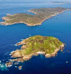
LUGO PORT OF/PORT DE VIVEIRO SERVICES
MARINA VIVEIRO SERVICES
NAUTICAL CHARTS/CARTES NAUTIQUES :
IHM 4082, 932, 931, 40
Coordinates/Coordonnées : 43º 40’N 007º 36’W TRANSPORT ROUTES AND ACCESS
Roads: National 642 from Ribadeo to Ferrol. Regional road C 640 towards Vilalba - Lugo.
Trains: Viveiro Station. Tel FEVE: +34 982 550 722. Buses: Viveiro-Celeiro Bus Station,
connection with Galicia and Asturias. Tel: +34 982 551 177. Airports: A Coruña (Alvedro)
140 km away. Tel: +34 981 187 200. Santiago Airport (Lavacolla) 170 km away. Tel: +34
981 547 501. Airport: Vigo (Peinador) 220 km away. tel.: +34 986 268 200.
COMMUNICATIONS ET ACCÈS
Route : Nationale 642 reliant Ribadeo à Ferrol. Régionale C 640, direction Vilalba-Lugo.
Train : Gare ferroviaire de Viveiro. FEVE tél. +34 982 550 722. Autocar : Gare routière
de Viveiro-Celeiro. Liaison avec toute la Galice et les Asturies. tél. +34 982 551 177.
Aéroports : A Coruña (Alvedro) à 140 km. tél. +34 981 187 200. Aéroport de Santiago
(Lavacolla) à 170 km. tél. +34 981 547 501. Aéroport : Vigo (Peinador) à 220 km. tél.
+34 986 268 200.
TOURISM
Abundant archaeological remains. There are still gates standing from the remains of its
walls: the enclosure wall gate, of Romanesque origin; the town wall gate, built in 1217;
and the castle bridge gate. The Romanesque style left behind significant traces, some
of the most noteworthy being the churches of San Pedro, Santa María and the old mo-
nastery church of San Francisco. Viveiro is the largest population centre on the coast of
Lugo. It has a marina and fishing port. Due to its location and its exceptional position, it
is considered one of Galicia’s finest ports, which is shown by the large number of vessels
from across Europe who come to this port. It is the tourism, commercial and administra-
tive centre of the area known as the ‘Mariña Lucense’. Of great artistic importance, any
SAILING DIRECTIONS: INSTRUCTIONS NAUTIQUES : visit to this town that we might plan must, inevitably, begin by passing through any of the
Between Punta do Faro Punta to the east and Punta So- Entre la pointe Faro à l’E. et la pointe Socastro à 1 M à three gates that are still preserved in the old walls. Its Holy Week religious processions
l’O. s’ouvre la ria de Viveiro, en forme de V, qui s’étend are famous.
castro 1 M away to the west is the mouth of the Viveiro
Ria, which runs north to south in a V-shape and ends up du N. au S. et finit par fusionner avec la vallée du Lan- TOURISME
gradually disappearing in the valley of the River Lan- dro, qui nous mène au port de plaisance. Les côtes de Abondants vestiges archéologiques. De l’ancienne muraille, il ne reste aujourd’hui que
dro. There is a canal at the mouth of this river that will la ria de Viveiro sont propres, à flancs abrupts et suffi- trois portes : la porte romane de Valado, la porte de la Vila — construite en 1217 — et
samment hautes pour protéger les bateaux des vents la porte de Castelo da Ponte. L’art roman a laissé une empreinte profonde dans la com-
take us to the marina. The shores of the Viveiro Ria are mune à travers les églises San Pedro, Santa María et l’ancienne église conventuelle San
clean, steep and high enough to provide good shelter du 3e et 4e quadrant, dans le versant occidental, et des Francisco. Viveiro est la localité la plus importante de la côte de Lugo. Elle compte un port
vents N.-E. et E. dans le versant oriental. Nous pourrons de pêche et un port de plaisance. En raison de sa situation et de sa position privilégiée, il
from the winds from the 3rd and 4th quadrant on its
naviguer très près de la côte. Les fonds sont principale- est considéré comme l’un des meilleurs ports de Galice. D’ailleurs, la grande quantité de
western side, and the from the NE and east on its east. bateaux venant de toute l’Europe qui y accostent en témoigne. C’est le centre touristique,
ment constitués de sable. Avant le chenal qui conduit au
We can navigate very close to the coast. The seabed is commercial et administratif de La Mariña Lucense. Les visiteurs voulant découvrir cette
port de plaisance de Viveiro se trouvent les importantes
mostly sand. Located before the canal that enters the commune, présentant un grand intérêt artistique, passeront irrémédiablement par l’une
installations du port de pêche et de commerce de Ce- des trois portes de l’ancienne muraille. Les processions religieuses qui ont lieu pendant
Viveiro marina are Celeiro’s important commercial and leiro. Le courant est assez intense dans le chenal de la Semaine sainte sont également célèbres.
finishing facilities. The current in the Landro canal can Landro ; il peut atteindre les 3 nœuds lors des marées
be intense, reaching three knots at spring tides. de vive eau.
Marks. Arrival in port. Amers. Arrivée au port.
CONTACT/CONTACT : Marina Viveiro
1678 Punta da Roncadoira lighthouse. Avda. de Ramón Canosa s/n · 27850 Viveiro – LUGO
1678 Phare de la pointe Roncadoira
Phone./Tél. +34 690 604 452
D-1679_1 Punta do Faro lighthouse. The Viveiro Ria. D-1679_1 Phare de la pointe Faro. Ria de Viveiro +34 881 920 482
1684 Isla Coelleira lighthouse. 1684 Phare de l’île Coelleira FEATURES: Fax +34 981 228 181
1681 Celeiro lighthouse. Breakwater tip. 1681 Phare de Celeiro. Pointe de la digue de protection. CARACTÉRISTIQUES :
The jetty of the Port of Celeiro is the best mark for L’épi du Port de Celeiro constitue le meilleur amer pour Moorings/Amarrages : 235 www.marinacoruna.es
reaching the Landro canal and the marina in Viveiro. We atteindre le chenal de Landro et la marina de Viveiro. Max. Length/Longueur max. : 20 m www.marinaviveiro.es
pass round the tip of the jetty with the required care. To Nous dépasserons la pointe de l’épi en observant une Depth Máx./Tirant d’eau max. : 3 m marinacoruna@marinacoruna.es
our port side, we see the Celeiro’s southern pier and, a distance de sécurité convenable. À bâbord apparaîtra Port mouth/Entrée : 80 m marinaviveiro@marinaviveiro.es
little further away at 400 m to the south, is the head of le quai S. de Celeiro et, à 400 m au S., la tête de la
the dock for the River Landro canal and the beginning levée du Landro et le début du chenal d’entrée. Le che-
of the entrance canal. The River Landro’s canal has an nal de Landro dispose d’une entrée de 80 m de large.
Nous mettrons le cap au S.-E. et naviguerons 0,25 M en
80 m mouth. The first bearing heads towards the south-
east; we navigate 0.25 M heading south some 300 m évoluant vers le Sud. À 300 m environ, nous aurons à
and at port side we are at the mouth of the marina in bâbord l’entrée du port de plaisance de Viveiro. L’accès
Viveiro. Accessing the marina presents no difficulties as à la marina ne présente aucune difficulté ; le chenal est
the canal is dredged to 3 m. dragué sur 3 m.
12
A CORUÑA PORT OF/PORT D’ORTIGUEIRA C. N. DE SANTA MARTA DE ORTIGUEIRA SERVICES
SERVICES
NAUTICAL CHARTS/CARTES NAUTIQUES :
IHM 4083, 931
Coordinates/Coordonnées : 43º 43’ 5’’, 7º 21’ 3’’ TRANSPORT ROUTES AND ACCESS
Roads: Regional road C-642. It runs along the coast from Ferrol to Ribadeo.
Trains: FEVE narrow gauge railway. Ortigueira Station, tel. +34 981 422 201.
Buses: The Arriva bus company links Ortigueira with the main cities in Galicia.
Airports: Nearest airport: Alvedro (A Coruña), tel. +34 981 187 200; Lavacolla (Santiago),
tel. +34 981 547 501.
COMMUNICATIONS ET ACCÈS
Route : Route secondaire C-642, qui longe la côte de Ferrol à Ribadeo.
Train : Chemin de fer à voie étroite FEVE. Gare d’Ortigueira ; tél. +34 981 422 201.
Autocar : La société Arriva assure la liaison avec les principales villes galiciennes.
Aéroports : Aéroport le plus proche : Alvedro (A Coruña) ; tél. +34 981 187 200 ; Lava-
colla (Santiago), tél. +34 981 547 501.
TOURISM
The port of Ortigueira is in the middle of the eastern coast of Estaca de Bares. Summer
is when boats arrive at this port; nonetheless, a small fleet operating seasonally moors
its boats here. It currently boasts some nice water sport facilities. The town where it is
located – Santa Marta de Ortigueira – is internationally known for its celebration of the
Celtic World Festival. In fact, there are very abundant prehistoric remains from pre-Celtic,
Celtic and later periods.
TOURISME
Le port d’Ortigueira se trouve au milieu de la côte orientale d’Estaca de Bares. Les plai-
sanciers entrent dans ce port durant la saison estivale. Toutefois, une flottille de pêche
saisonnière y mouille. À l’heure actuelle, il compte de bonnes installations nautiques et
de plaisance.
Le village dans lequel il se trouve, Santa Marta de Ortigueira, est connu à l’échelle in-
ternationale grâce à son Festival du Monde celte. La zone recèle de nombreux vestiges
SAILING DIRECTIONS: INSTRUCTIONS NAUTIQUES :
Il existe une barre, la barre de Santa Marta, entre l’île préhistoriques, préceltiques, celtiques et postérieurs.
The Santa Marta sand bar opens between San Vicente
Island on the east and the Punta do Frade on the west, San Vicente à l’E. et la pointe Frade à l’O., la partie
with the navigable part being that closest to the western navigable étant la plus proche à la partie occidentale
de l’île. Nous accéderons à l’entrée par le N.-O., en
part of the island. We access the mouth via the NW,
prenant en compte la présence de l’épave d’un bateau
paying attention to the remains of the hull of a boat échoué en face de la plage de Fornos, qui est recouverte
off Fornos beach that is covered at high tide. We pass à marée haute. Nous naviguerons au milieu de la barre
through the centre of the bar with the westernmost tip en ayant la pointe la plus occidentale de l’île à bâbord
of the island on port tack and heading more towards et avancerons vers elle, en navigant très près de ses
it, sailing very close to the rocks at a distance of about rochers à une distance d’environ 15/20 m. Nous
15/20 m. We follow that course TH: 195º, past the sand suivrons ce cap Rv : 195º. Après la barre de sable, nous
bar we pull heavily towards starboard going through the mettrons le cap sur l’Er et naviguerons au milieu de ce FEATURES: CONTACT/CONTACT :
centre of the canal, which is about 200 m wide, but not chenal, très peu profond et d’une largeur de 200 m. Le CARACTÉRISTIQUES : Peirao Deportivo s/n
Club Nautique d’Ortigueira a installé des bouées rouges Moorings/Amarrages : 131 Ortigueira - A CORUÑA
very deep. Port mouth/Entrée : 80
et vertes qui nous indiquent la route à suivre. Dans le Phone./Tél. +34 630 183 901
The Ortigueira Yacht Club anchored red and green buoys coude connu sous le nom de Sismundi l’on mesure des Max. Length/Longueur maximum : 12 m
that show us the route. In the bend known as ‘Sismundi’ Depths/Tirant d’eaus : 1,5 y 3 m
+34 629 840 276
sondes allant de 8 à 11 m. Lorsqu’il n’y a plus de place
the sounding lines measure between 8 and 11 m. This dans le port de plaisance, les voiliers utilisent cette zone
pool is used by some sailboats for anchoring if they comme lieu de mouillage.
info@nauticoortigueira.com
have not got a place in the marina. Les conditions changeantes du chenal d’entrée à la www.nauticoortigueira.com
Changing conditions experienced by the entrance canal ria de Santa Marta de Ortigueira ainsi que le risque
to the Santa Marta de Ortigueira Ria, and the possibility de déchirure rendent difficile l’accès à ce port. Il est
of a breaker in it, hamper access to this port. It is conseillé de rallier le port ou de le quitter une heure
advisable to enter or leave an hour before high tide. avant la marée haute.
14
A CORUÑA                                 PORT AUTHORITY OF FERROL-SAN CIBRAO
                                                                                                                                         A GRAÑA - CLUB DO MAR FERROL                                                          SERVICES
                                       AUTORITÉ PORTUAIRE DE FERROL-SAN CIBRAO                                                                                                                                                 SERVICES
NAUTICAL CHARTS/CARTES NAUTIQUES :
412 A, 4122 IHM
                                                              Coordinates/Coordonnées : 43º 28,7’N 008º 14,8’W                  TRANSPORT ROUTES AND ACCESS
                                                                                                                                The El Alvedro Airport is about 50 kilometres away.
                                                                                                                                Railway station in Ferrol
                                                                                                                                Connection with all of Galicia via the Atlantic Motorway AP-9

                                                                                                                                COMMUNICATIONS ET ACCÈS
                                                                                                                                À environ 50 km de l’aéroport d’Alvedro
                                                                                                                                Gare ferroviaire à Ferrol
                                                                                                                                Liaison avec toute la Galice à travers l’autoroute Autopista del Atlántico AP-9

                                                                                                                                TOURISM
                                                                                                                                Located about 50 km from A Coruña is a city that is eminently maritime, because of both
                                                                                                                                its history and its port, fishing and beaches.
                                                                                                                                It is highly advisable to visit at least the old town with the Magdalena neighbourhood,
                                                                                                                                where the 18th-century church of San Francisco is also located. The checkerboard
                                                                                                                                streets and gallery houses in this Magdalena neighbourhood are of great interest.
                                                                                                                                The Co-Cathedral of San Julián and the Castle of San Felipe – built in 1577 at the mouth
                                                                                                                                of the ria to defend the port of Ferrol – can also be seen. The castle of La Palma is also
                                                                                                                                located at the mouth of the ria.

                                                                                                                                TOURISME
                                                                                                                                Située à environ 50 km d’A Coruña, la ville de Ferrol est éminemment maritime en raison
                                                                                                                                de son histoire, son port, ses activités de pêche et ses plages.
                                                                                                                                Le visiteur ne manquera pas de découvrir au moins la vieille-ville et son quartier de la
                                                                                                                                Magdalena qui abrite notamment l’église San Francisco datant du XVIIIe siècle ainsi que
                                                                                                                                de charmantes rues en damier et des maisons à galerías (balcons vitrés). Il y a d’autres
SAILING DIRECTIONS:                                                INSTRUCTIONS NAUTIQUES :
                                                                                                                                lieux à visiter : la concathédrale San Julián et le château de San Felipe, construit en 1577
Ferrol Ria                                                         Ria de Ferrol
                                                                   La ria s’ouvre entre Prioriño Chico et la pointe Coitelada   à l’entrée de la ria pour défendre le port de Ferrol. Dans cette zone se lève également une
This ria opens between Prioriño Chico and Punta Coi-
                                                                   située à 1,2 mille à 130º et pénètre à l’intérieur des       autre demeure fortifiée, le château de la Palma.
telada located 1.2 M. away at 130°, penetrating inland
                                                                   terres et à l’E. sur environ 8 milles. Le premier tronçon
and towards the east about 8 M Its first section becomes           se rétrécit jusqu’aux châteaux de San Felipe au N. et de
narrower until the castles of San Felipe to the north and          la Palma au S., séparés de 370 m. Une fois doublés, ils
La Palma at its southern side, 370 m apart; once pas-              font place à une rade vaste et protégée. Les courants        FEATURES:                                                       CONTACT/CONTACT :
sed, they give way to a warm and wide bay. The currents            dans cette ria se font sentir à marée basse, vers            CARACTÉRISTIQUES :                                      Ctra. Alta del Puerto, 18-bajo
in this ria begin to be felt at low tide towards inland via        l’intérieur sur la côte S. et vers l’extérieur sur la côte   Moorings/Amarrages : 217                                   15401 Ferrol - A CORUÑA
the southern coast and out via the northern. At high tide,         N. À marée haute, la vitesse du courant de marée est
                                                                   très faible ou nulle, effet connu sous le nom anglais
                                                                                                                                Lengths/Longueurs : 6 a 12 m                        Phone/Tél. / fax +34 981 359 945
there are no currents measured; this effect is known                                                                            Depth/Tirant d’eau : 4 m
                                                                   de Slack Water (30 minutes avant ou après la haute
as ‘slack water’ (30 minutes before or after low or high           mer ou la basse mer le courant s’arrête). Lorsque la                                                                 clubdomarferrol@hotmail.com
tide, the current gradually stops). When low tide begins           marée commence à baisser, l’intensité et la direction                                                                     www.clubdomarferrol.es
all their direction and intensity are directed towards the         s’orientent vers l’entrée de la ria. Dans les zones les
mouth of the ria. In the narrowest and shallowest parts,           plus étroites et peu profondes, les courants peuvent                                                 Phone Autoridad Portuaria Ferrol-San Cibrao
a speed of about 2.5 to 3 knots can be reached.                    atteindre une vitesse allant de 2,5 à 3 nœuds. En                                                                             +34 981 338 075
From the W, the gorges of the Ventoso mountains to the             provenance de l’O., nous verrons les failles du mont
                                                                   Ventoso au N. et du mont Faro au S. (sur la cime duquel
north and, to the S, Mount Faro, (at night, the aerials
                                                                   des antennes sont allumées la nuit) dont les flancs
located on its summit are lit up) whose mountainside               descendent vers la mer. En provenance du N., nous
slopes down to the sea. If arriving from the N, once Prior         reconnaîtrons le cap Prior et naviguerons le long de la
is recognised, follow the coast to Prioriño by port side.          côte jusqu’à voir le cap Prioriño à Br.
                                                              16
A CORUÑA PORT AUTHORITY OF FERROL-SAN CIBRAO
CURUXEIRAS-CLUB DO MAR FERROL SERVICES
AUTORITÉ PORTUAIRE DE FERROL-SAN CIBRAO SERVICES
NAUTICAL CHARTS/CARTES NAUTIQUES :
412 A, 4122 IHM
Coordinates/Coordonnées : 43º 28,7’N 008º 14,8’W TRANSPORT ROUTES AND ACCESS
The El Alvedro Airport is about 50 kilometres away.
Railway station in Ferrol
Connection with all of Galicia via the Atlantic Motorway AP-9
COMMUNICATIONS ET ACCÈS
À environ 50 km de l’aéroport d’Alvedro
Gare ferroviaire à Ferrol
Liaison avec toute la Galice à travers l’autoroute Autopista del Atlántico AP-9
TOURISM
Located about 50 km from A Coruña is a city that is eminently maritime, because of both
its history and its port, fishing and beaches.
It is highly advisable to visit at least the old town with the Magdalena neighbourhood,
where the 18th-century church of San Francisco is also located. The checkerboard
streets and gallery houses in this Magdalena neighbourhood are of great interest.
The Co-Cathedral of San Julián and the Castle of San Felipe – built in 1577 at the mouth
of the ria to defend the port of Ferrol – can also be seen. The castle of La Palma is also
located at the mouth of the ria.
TOURISME
Située à environ 50 km d’A Coruña, la ville de Ferrol est éminemment maritime en raison
de son histoire, son port, ses activités de pêche et ses plages.
SAILING DIRECTIONS: INSTRUCTIONS NAUTIQUES : Le visiteur ne manquera pas de découvrir au moins la vieille-ville et son quartier de la
Ferrol Ria Ria de Ferrol
Magdalena qui abrite notamment l’église San Francisco datant du XVIIIe siècle ainsi que
La ria s’ouvre entre Prioriño Chico et la pointe
This ria opens between Prioriño Chico and Punta Coi- de charmantes rues en damier et des maisons à galerías (balcons vitrés). Il y a d’autres
Coitelada située à 1,2 mille à 130º et pénètre à
telada located 1.2 M. away at 130°, penetrating inland l’intérieur des terres et à l’E. sur environ 8 milles. lieux à visiter : la concathédrale San Julián et le château de San Felipe, construit en 1577
and towards the east about 8 M Its first section becomes Le premier tronçon se rétrécit jusqu’aux châteaux à l’entrée de la ria pour défendre le port de Ferrol. Dans cette zone se lève également une
narrower until the castles of San Felipe to the north and de San Felipe au N. et de la Palma au S., séparés
autre demeure fortifiée, le château de la Palma.
de 370 m. Une fois doublés, ils font place à une
La Palma at its southern side, 370 m apart; once pas-
rade vaste et protégée. Les courants dans cette
sed, they give way to a warm and wide bay. The currents ria se font sentir à marée basse, vers l’intérieur
in this ria begin to be felt at low tide towards inland via sur la côte S. et vers l’extérieur sur la côte N. À
marée haute, la vitesse du courant de marée est
FEATURES: CONTACT/CONTACT :
the southern coast and out via the northern. At high tide, CARACTÉRISTIQUES : Ctra. Alta del Puerto, 18-bajo
très faible ou nulle, effet connu sous le nom an- Moorings/Amarrages : 254
there are no currents measured; this effect is known
glais de Slack Water (30 minutes avant ou après 15401 Ferrol - A CORUÑA
Lengths/Longueurs : 6 a 12 m Phone/Tél. / fax +34 981 359 945
as ‘slack water’ (30 minutes before or after low or high la haute mer ou la basse mer le courant s’arrête).
tide, the current gradually stops). When low tide begins Lorsque la marée commence à baisser, l’intensité
et la direction s’orientent vers l’entrée de la ria. clubdomarferrol@hotmail.com
all their direction and intensity are directed towards the
Dans les zones les plus étroites et peu profondes, www.clubdomarferrol.es
mouth of the ria. In the narrowest and shallowest parts,
les courants peuvent atteindre une vitesse allant
a speed of about 2.5 to 3 knots can be reached. de 2,5 à 3 nœuds. En provenance de l’O., nous PhoneTél. Autoridad Portuaria Ferrol-San Cibrao
From the W, the gorges of the Ventoso mountains to the verrons les failles du mont Ventoso au N. et du +34 981 338 075
north and, to the S, Mount Faro, (at night, the aerials mont Faro au S. (sur la cime duquel des antennes
sont allumées la nuit) dont les flancs descendent
located on its summit are lit up) whose mountainside
vers la mer. En provenance du N., nous recon-
slopes down to the sea. If arriving from the N, once Prior naîtrons le cap Prior et naviguerons le long de la
is recognised, follow the coast to Prioriño by port side. côte jusqu’à voir le cap Prioriño à Br.
18A CORUÑA PORT AUTHORITY OF FERROL-SAN CIBRAO SERVICES
AUTORITÉ PORTUAIRE DE FERROL-SAN CIBRAO CLUB NÁUTICO BARRIO DE CARANZA SERVICES
NAUTICAL CHARTS/CARTES NAUTIQUES :
412 A, 4122 IHM
Coordinates/Coordonnées : 43º 28,7’N 008º 14,8’W TRANSPORT ROUTES AND ACCESS
The El Alvedro Airport is about 50 kilometres away.
Railway station in Ferrol
Connection with all of Galicia via the Atlantic Motorway AP-9
COMMUNICATIONS ET ACCÈS
À environ 50 km de l’aéroport d’Alvedro
Gare ferroviaire à Ferrol
Liaison avec toute la Galice à travers l’autoroute Autopista del Atlántico AP-9
TOURISM
Located about 50 km from A Coruña is a city that is eminently maritime, because of both
its history and its port, fishing and beaches.
It is highly advisable to visit at least the old town with the Magdalena neighbourhood,
where the 18th-century church of San Francisco is also located. The checkerboard
streets and gallery houses in this Magdalena neighbourhood are of great interest.
The Co-Cathedral of San Julián and the Castle of San Felipe – built in 1577 at the mouth
of the ria to defend the port of Ferrol – can also be seen. The castle of La Palma is also
located at the mouth of the ria.
TOURISME
Située à environ 50 km d’A Coruña, la ville de Ferrol est éminemment maritime en raison
de son histoire, son port, ses activités de pêche et ses plages.
SAILING DIRECTIONS: INSTRUCTIONS NAUTIQUES : Le visiteur ne manquera pas de découvrir au moins la vieille-ville et son quartier de la
Ferrol Ria Ria de Ferrol
Magdalena qui abrite notamment l’église San Francisco datant du XVIIIe siècle ainsi que
La ria s’ouvre entre Prioriño Chico et la pointe
This ria opens between Prioriño Chico and Punta Coi- de charmantes rues en damier et des maisons à galerías (balcons vitrés). Il y a d’autres
Coitelada située à 1,2 mille à 130º et pénètre à
telada located 1.2 M. away at 130°, penetrating inland l’intérieur des terres et à l’E. sur environ 8 milles. lieux à visiter : la concathédrale San Julián et le château de San Felipe, construit en 1577
and towards the east about 8 M Its first section becomes Le premier tronçon se rétrécit jusqu’aux châteaux à l’entrée de la ria pour défendre le port de Ferrol. Dans cette zone se lève également une
narrower until the castles of San Felipe to the north and de San Felipe au N. et de la Palma au S., séparés
autre demeure fortifiée, le château de la Palma.
de 370 m. Une fois doublés, ils font place à une
La Palma at its southern side, 370 m apart; once pas-
rade vaste et protégée. Les courants dans cette
sed, they give way to a warm and wide bay. The currents ria se font sentir à marée basse, vers l’intérieur
in this ria begin to be felt at low tide towards inland via sur la côte S. et vers l’extérieur sur la côte N. À
the southern coast and out via the northern. At high tide, marée haute, la vitesse du courant de marée est
très faible ou nulle, effet connu sous le nom an-
FEATURES: CONTACT/CONTACT :
there are no currents measured; this effect is known CARACTÉRISTIQUES : Avda. de Castelao, s/n Centro Cívico 2º
glais de Slack Water (30 minutes avant ou après Moorings/Amarrages : 141
as ‘slack water’ (30 minutes before or after low or high la haute mer ou la basse mer le courant s’arrête). 15406 Ferrol - A CORUÑA
Lengths/Longueurs : 6 a 12 m Phone/Tél. +34 633 591 515
tide, the current gradually stops). When low tide begins Lorsque la marée commence à baisser, l’intensité
all their direction and intensity are directed towards the et la direction s’orientent vers l’entrée de la ria.
Dans les zones les plus étroites et peu profondes, clubnauticobarriodecaranza@hotmail.com
mouth of the ria. In the narrowest and shallowest parts,
les courants peuvent atteindre une vitesse allant
a speed of about 2.5 to 3 knots can be reached. de 2,5 à 3 nœuds. En provenance de l’O., nous Phone Autoridad Portuaria Ferrol-San Cibrao
From the W, the gorges of the Ventoso mountains to the verrons les failles du mont Ventoso au N. et du +34 981 338 075
north and, to the S, Mount Faro, (at night, the aerials mont Faro au S. (sur la cime duquel des antennes
sont allumées la nuit) dont les flancs descendent
located on its summit are lit up) whose mountainside
vers la mer. En provenance du N., nous recon-
slopes down to the sea. If arriving from the N, once Prior naîtrons le cap Prior et naviguerons le long de la
is recognised, follow the coast to Prioriño by port side. côte jusqu’à voir le cap Prioriño à Br.
20A CORUÑA PORT OF/PORT D’ARES SERVICES
CLUB NÁUTICO RÍA DE ARES SERVICES
NAUTICAL CHARTS/CARTES NAUTIQUES :
IHM 412, 412A
Coordinates/Coordonnées : 43º 25’ 1’’, 8º 15’ 0’’ TRANSPORT ROUTES AND ACCESS
Roads: Local road.
Trains: Stations near Ares: Pontedeume (9 km away) Fene (10 km away) Ferrol: FEVE
station, tel. +34 981 370 401.
Buses: Ferrol bus station, tel. +34 981 324 751.
Airports: Alvedro (A Coruña), tel. +34 981 187 200; Lavacolla (Santiago), tel. +34 981
547 501.
COMMUNICATIONS ET ACCÈS
Routes : Route locale.
Train : Gares ferroviaires près d’Ares : Pontedeume (à 9 km) Fene (à 10 km) Ferrol : gare
FEVE, tél. +34 981 37 04 01.
Autocar : Gare routière de Ferrol, tél. +34 981 324 751.
Aéroport : Alvedro (A Coruña), tél. +34 981 187 200 ; Lavacolla (Santiago), tél. +34 981
547 501.
TOURISM
The Fragas del Eume is a nature park created on 30 July 1997 that covers 9,126 hectares
on the banks of the River Eume, specifically in the municipalities of Cabañas, A Capela,
Monfero, Pontedeume and As Pontes de García Rodríguez, all in the province of A Coruña.
Currently residing in the park are 521 people in the five municipalities listed above.
It was also declared a Site of Community Importance with the same boundaries as the
SAILING DIRECTIONS: INSTRUCTIONS NAUTIQUES : park’s. Its old-growth forests are considered to be one of the best examples of thermo-
DAYTIME APPROACH APPROCHE DE JOUR philic Atlantic forest on the European continent.
The wide mouth (3.2’ M) of Ares and Betanzos ria is La vaste entrée (3,2 milles) de la ria d’Ares et Betanzos
between the tip of Coitelada and that of Seixo Branco, qui se trouve entre la pointe Coitelada et la pointe Seixo
Branco, est exposée aux mers et aux vents du quatrième TOURISME
facing towards the seas and winds from the fourth qua-
quadrant. Cette ria est divisée en deux bras : le premier Créé le 30 juillet 1997, le parc naturel Fragas del Eume de 9 126 hectares longe les
drant. This ria is divided into two branches: one towards
the south-southeast – the Betanzos Ria – and the other vers le S.S.-E. – ria de Betanzos — et le second vers l’E. berges de l’Eume. Il s’étend sur les terres des communes de Cabañas, A Capela, Monfero,
to the east – the Ares Ria. It is the latter that leads to – ria d’Ares —. Ce dernier est celui qui conduit à l’entrée Puentedeume et As Pontes de García Rodríguez, situées dans la province d’A Coruña. À
du port d’Ares. Pour l’atterrage, nous procéderons de la l’heure actuelle, 521 personnes résident dans le parc, dans les cinq communes préci-
the entrance of the port of Ares. Do as follows at the
façon suivante : nous nous positionnerons à un mille
landfall: Located one mile true south of Cape Prioriño tées. Cet espace a été classé « Lieu d’importance régionale » et il est considéré comme
au S. vrai du cap Prioriño Chico, nous mettrons le cap
Chico we head to 130º until we stop seeing the Hércu- à 130º jusqu’à ne plus voir la Tour d’Hercule. Dès lors, l’un des meilleurs exemples de forêt atlantique thermophile du continent européen.
les lighthouse tower, at which point we will slowly turn nous avancerons peu à peu vers 40º à bâbord, jusqu’à
40° to port until we see the end of the breakwater that voir la fin de l’épi qui protège le port ou, éventuellement,
protects the harbour or, if appropriate, the red buoy that la balise rouge qui le couronne. Nous mettrons alors le
crowns it, then head towards it. Landfall is not difficult cap vers elle. L’entrée ne présente pas de difficultés
as long as we consider the sandbank and reefs of A à condition de tenir compte du bas-fond et des récifs
Miranda, located about 0.68 M S-SW of Miranda, and d’A Miranda, situés à 0,68 mille au S.S.-O. de la pointe CONTACT/CONTACT :
the Catarroso sandbank, at 0.1 M south-southeast of Miranda, et du bas-fond de Catarroso, à 0,1 mille Avda. General Gabeiras, s/n
Punta Cruz. To avoid them, it will be enough to give a au S.S.-E. de la pointe Cruz. Pour les éviter, il suffit 27700 Ares - A CORUÑA
safety margin of slightly less than a mile to the coast de prendre du tour, environ 1 mille de la côte pour le Phone/Tél. +34 677 448 895
for the former, and a mile and a half or so for the latter. premier et de 0,5 pour le second. FEATURES:
APPROCHE DE NUIT CARACTÉRISTIQUES : Fax +34 981 445 046
NIGHTTIME APPROACH
We will continue in the same manner, taking into account Nous procéderons de la même façon tout en prenant Moorings/Amarrages : 341
en compte le balisage : en provenance du N., nous Length/Longueurs : 6 a 16 m secretaria@nauticoares.com
the buoys: Coming from the north we will sail towards
the light of the lighthouse at Cape Prioriño Chico (DB 5s naviguerons à la recherche de la lumière du phare du Depth/Tirant d’eau : 2 a 4 m www.nauticoares.com
cap Prioriño Chico (DB 5s 36m 23M visible entre 225º
36m 23M visible between 225° and 129.5°) with that
et 129,5º) en ayant par la poupe et comme référence
of Cape Prior (GpD(1 2)B 15s107m 22M) at stern and celle du cap Prior (GpD(1+2)B 15s107m 22M). Situés à PASSEPORT ESCALES
as reference. Located one mile true south from Cape un mille au S. vrai du cap Prioriño Chico, nous mettrons
Prioriño Chico we head to 130º until we stop seeing the le cap à 130º jusqu’à ne plus voir la lumière du phare
light of the Hércules lighthouse tower (GpD(4)B 20s 106 de la Tour d’Hercule (GpD(4)B 20s 106 m 23M), le plus
m 23M), the world’s oldest active lighthouse, at which vieux phare au monde toujours en fonctionnement. Dès
time we will gradually turn 40º to port until we see the lors, nous avancerons peu à peu 40º à bâbord, jusqu’à
light at the end of the breakwater of the Port of Ares voir la lumière de la fin de l’épi du Port d’Ares (GpD(3)
(GpD(3)R 9s 12m 5M). R 9s 12m 5M).
22You can also read