BatsA History of the Hermitage Stream and its Tributaries Restoration and Enhancement Projects - Robert West and Ralph Cousins
←
→
Page content transcription
If your browser does not render page correctly, please read the page content below
batsA History of the Hermitage Stream
             and its Tributaries
   Restoration and Enhancement Projects

The Riders Stream entering a flooded Hermitage Stream at Corhampton
Crescent

           Robert West and Ralph Cousins
                           July 2019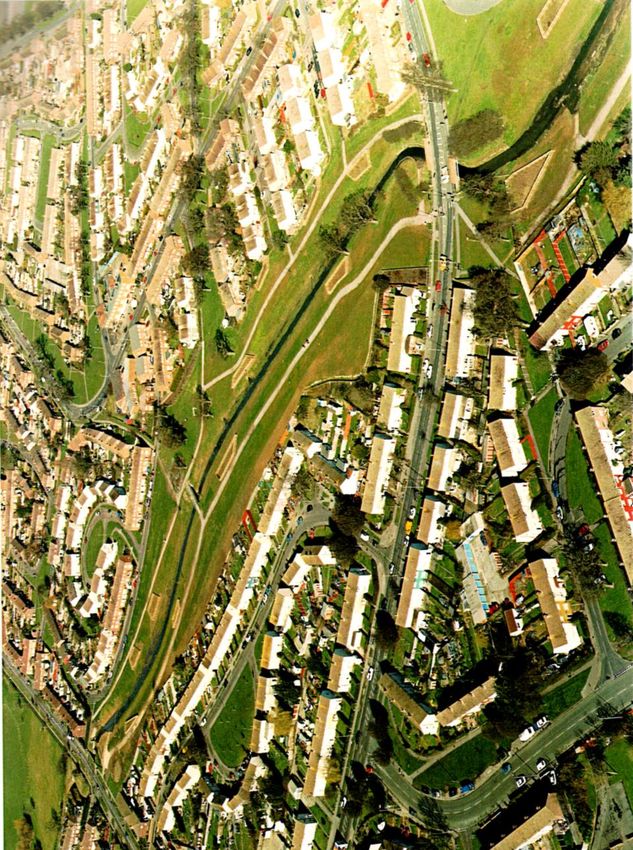
Original meandering route of the Hermitage Stream

                       2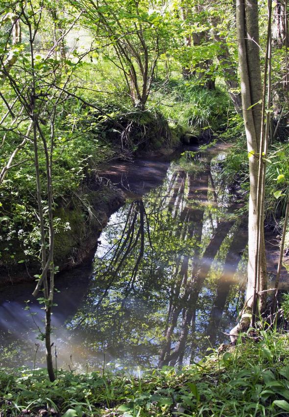
Borough of Havant Local History Booklet No. 105

           Read all booklets on line at:
 thespring.co.uk/heritage/local-history-booklets/

                        3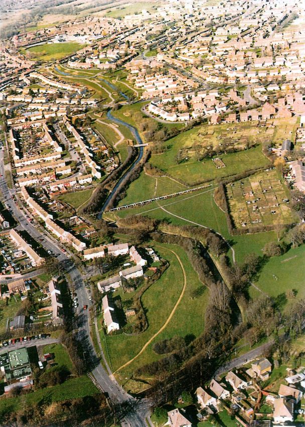
A History of the Hermitage Stream and its Tributaries
                                 Robert West
                                Introduction
No one would ever claim that the Hermitage Stream is – or ever has been – a
dramatic, picturesque or especially significant watercourse. Draining less than
70 sqkm of South East Hampshire it is, in many places, now either invisible or
straitjacketed in brick or concrete with much of its course surrounded by the
modern housing developments of Waterlooville and Leigh Park. But even
when it flowed almost entirely through open countryside it was never a stream
to enthral or inspire. Indeed the only part of its catchment area that has ever
attracted the attention of the artist or the poet is the pre-housing estate Leigh
Park, whose gardens and grounds as we see them today are largely the
creation of Sir George Staunton in the 1820s and 30s. In about 1836 Staunton
commissioned the Chichester artist J.F. Gilbert to produce a number of views
of the estate, including Leigh Water, which had recently been created by
damming a small headwater stream,1 whilst in 1862 Charles Rogers Cotton
also depicted Leigh Water in one of a number of watercolours which he
produced after he had settled, in 1860, at Stansted College, an almshouse (now
demolished) for retired and impoverished practitioners in the wine trade.
The one poet – though a decidedly amateur one – who has seen the Hermitage
Stream as a fit subject is James King who, in 1829 composed A Poem on
Leigh Park. This, however, is an almost sycophantic paean to Staunton (King
was actually one of his tenants) and his descriptions of the gardens and
grounds is, for modern tastes, far too florid and gushing. His treatment of the
Hermitage Stream, which here is little more than a collection of unimpressive
rivulets, is typical of his style, although to begin with he is rather
uncharacteristically muted:
                 And here a dun, discoloured streamlet mark
                  That flows all darkly and divides the park
                  Crowned with its sedgy tresses see it stray
                 And to the murmuring ocean wend its way.

                                       4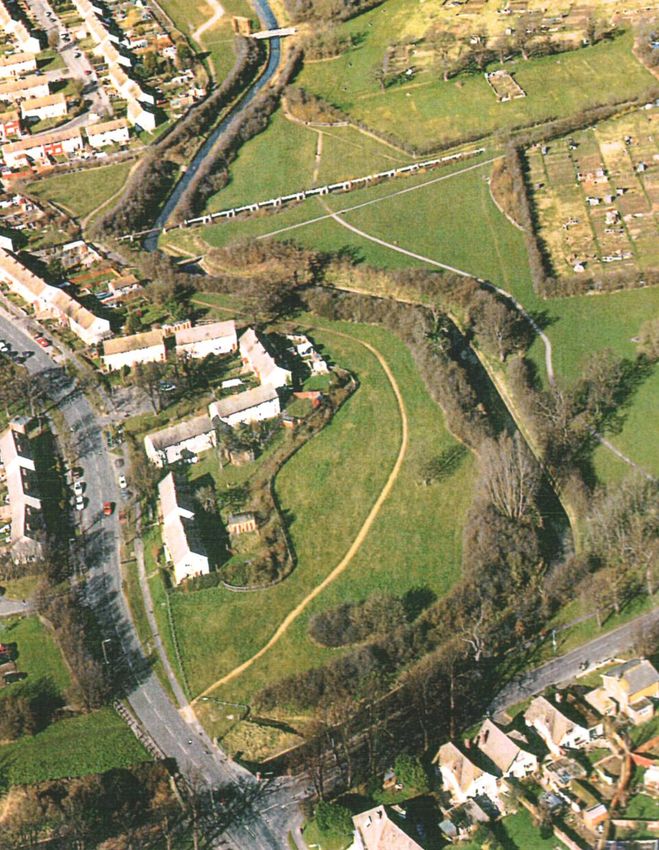
Later, however, he becomes more expansive:
                  How pleasingly its darksome waters flow
             Chequering the scene where all is light and glow.
and further on he continues:
               And here once more that winding stream we see
                   That rolled its sullen wave so gloomily.
              Say what hath smiled these angry waves to peace
             And led their hoarse-resounding murmurs to cease?
                  All crystal here its noiseless waters seem
              With scarce a wave to break the quivering gleam.
                Glassy as Truth their limpid course they run,
                Bickering for joy beneath the cloudless sun.
                  And marvel not for here the Naiad dwells
                And calms the waters with her gentle spells.
                The peaceful Halcyon flies the twilight cave
                  To sleek her plumage in the sunny wave.
                The spangled trout forsakes the river's pride
              Well pleased along this humble stream to glide.2
And yet, in many respects, this ‘humble stream’ is indeed one of varied
interest, with much to tell us about the many ways in which man has,
throughout the ages, sought to control or utilise even the most modest and
unpromising of watercourses.
Except for a thin coastal strip of chalk overlaid with alluvium, and another
narrow band, immediately to the north of it, of Reading Beds (a
complex mixture of sands, clays and gravels) the geology of the Hermitage
catchment area is entirely London Clay. This means that virtually all of the
rain that falls upon it becomes surface run-off, and in consequence the
Hermitage Stream has a very variable flow. Prolonged drought, especially in
summer, can reduce it to little more than a trickle, whilst prolonged rain can
turn it into a torrent. Even a short burst of heavy rain can see its level rise
dramatically in almost an instant as was demonstrated on 14 August 1955
when the Hampshire Rivers Board recorded an increase in flow from a mere
                                      5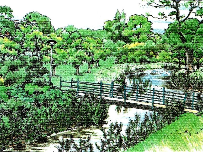
one cubic foot per second to 110 feet per cubic second in just 12 minutes after
a violent storm.3
This volatility is to some extent mitigated by the fact that much of the land
immediately adjacent to it is naturally boggy and acts like a sponge, thus
regulating its flow. This is less true now than it was in earlier times, due to
extensive urbanisation, but truer now than it was in the last quarter of the
twentieth century, since much of its course through Leigh Park has been
returned to a habitat of sloping grassy banks and reeds, after having been lined
and paved with concrete in the 1970s.
A good indication of how marshy the immediate environs of the stream used
to be is clearly shown on the earliest surviving map of a moderately large
scale (Four inches to the mile) that includes the Havant area, McKenzie's,
General Plan of the Island of Portsea and the Gosport Side ... and Soundings
of Spithead, Portsmouth and Langston Harbours (dated 1784) which depicts
an admittedly simplified and stylised Hermitage Stream but with broad strips
of marsh on either side of it for virtually the whole length of its course.
This combination of volatile flow and boggy banks has meant that no
settlement ever grew up on it until after the Second World War, and also
ensured that it was quite unsuitable as a source of power for water mills. It is
true that there were once two very important mills very close to it –
Bedhampton Upper and Lower mills which have now entirely vanished (only
the mill pond and the Mill House belonging to the Lower Mill survive). But
these mills were located here because of the copious chalk springs which,
quite coincidentally, erupt adjacent to the stream and discharge into it,
dramatically increasing the volume of its flow for the last few hundred metres
of its course. Indeed the close proximity of the stream, with its unpredictable
volumes of often heavily polluted water was actually a significant handicap to
these mills' operations.
These twin problems of flooding and pollution became even more acute after
1889 when the mills were finally abandoned and the Bedhampton springs
became the largest source of supply for the Portsmouth Water Company.

                                       6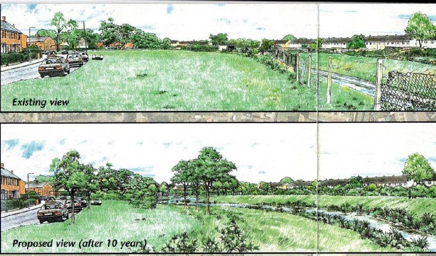
McKenzie's General Plan

          7
Indeed the Company soon took the drastic step of diverting the whole of the
lower course of the Hermitage that ran past the waterworks through a large
pipe which emptied directly into Langstone Harbour. This too, however,
caused its own problems and eventually the course of the stream was restored,
although only after major work to deepen and widen its course had been
undertaken. (The pipe was retained, however, to act as a relief conduit in times
of heavy flood).
In short, there has barely been a stretch of the Hermitage Stream or its
headwaters which have not, at one time or another, been diverted, dammed,
culverted or canalised to render it either more beautiful, more beneficial, or –
at the very least – less of a nuisance.

                   Main Headwater: Upper Hermitage
What is usually regarded as the principle headwater of the Hermitage Stream
has its origins to the north of the Queen's Inclosure, just south of Padnell Lane
in the vicinity of Padnell Junior School. Before this area was developed after
the Second World War there was an open watercourse here, but now the
embryonic river makes its first appearance when it emerges from a culvert
under Park Lane opposite Winscombe Avenue. Thereafter it meanders through
the Inclosure, which is actually one of the most pleasant spots in the whole of
the Hermitage basin – although it must be admitted that the modest little
stream does not make a significant contribution to the picturesqueness of the
scene.
The Queen's Inclosure is one of the largest and most impressive remnants of
the ancient and extensive Forest of Bere. Once known as Bulls Lodge Woods
it was particularly renowned for the quality of its oak timber (especially useful
for shipbuilding) and rows of ‘plantation’ oaks can still be seen, as well as a
number of very fine yew trees.
At the southern boundary of the Inclosure the stream turns westwards, running
in what is clearly an artificially straightened channel along the edge of the
gardens in Burnside, before turning south again under Highfield.
Here, until the 1960s, was Highfield Lodge, which took its name from one of

                                       8
the old lodges in the Forest of Bere. The house is first recorded in l833
although there must surely have an older property on the site. Old maps show
that the stream was once dammed here to form ponds. These were certainly
ornamental features in the grounds of the house although they may have
originally been medieval fish ponds.4 Now, however, all traces of house,
grounds and ponds have vanished beneath the late twentieth-century housing,
and the stream can now only be glimpsed briefly as it passes under Highfield
at the end of Billett Avenue (named after John Billett the first owner of
Highfield Lodge). It then flows southward towards Hulbert Road and turns
east under Ferndale and Tempest Avenue before re-emerging at Outhurst
Wood, another remnant of the Forest of Bere. Here the stream is noticeably
more mature than in the Queen's Inclosure and has cut quite a steep-sided
valley through the soft clay. It forms the focus of a circular walk, created in
1998, which runs along each bank with a footbridge over the stream at the
southern end. As in the Queen's Inclosure there is some impressively mature
woodland here. The stream soon disappears once more however, this time
under the A3M, constructed in the 1970s, and then under the service road for
the new Dunsbury Business Park (on the site of Dunsbury Hill Farm) which,
at the time of writing (2019) is still in the early stages of development. It can
only be picked up again on the south side of this new road where it re-emerges
in an open space between Bushy Lease (another Forest of Bere survival) and
the open ground to the west of Ramsdale Avenue in the Warren Park area. Just
north of Park House Farm Way it receives a culverted stream that drains
Bushy Lease, and here, too, we first encounter the measures taken in the 1970s
to prevent flooding by lining the bed and banks with concrete and paving.
(This will be dealt with below). It then crosses under Park House Farm Way
and can be followed along a tarmac footpath and cycleway between Park
Community School and Keyhaven Drive.
It then flows under Middle Park Way where it receives its first major tributary,
the Park Lane stream.

                                       9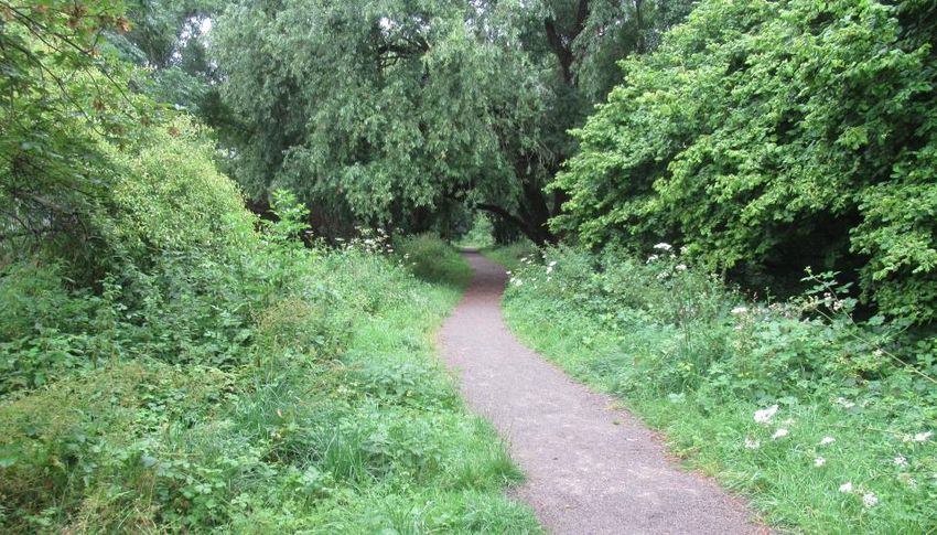
Park Lane Stream
This has its origin in two main headwaters.
The western branch used to rise in Hazleton Wood, but this has now been
felled and replaced by the Hazleton Way housing estate, and so today the
stream makes its first appearance when it emerges from a pipe on the eastern
side of Greenfield Crescent. It then crosses under Sheepwash Lane, in reality
now no more than a bridleway although it is an ancient track leading from
Horndean to Padnell. It then flows through the Waterlooville Golf Club course
and here forms two small lakes (originally there were three, the smallest
central one having been lost). It has been speculated that these were medieval
fish ponds, but as they do not appear on the 1838 Blendworth Tithe Map they
must have been excavated sometime between then and 1897 when they are
shown on the large-scale Ordnance Survey map. It is possible that they were
dug for clay for the nearby Padnell Brick Works although the land was
actually part of Blendworth Common. But it is more likely that they were
created for purely recreational purposes since the 1897 map shows a Boat
House on the banks of the larger (easternmost) one. For whose benefit,
however, is uncertain. The nearest large house is Padnell Grange, the
residence in the nineteenth century of the Dotterill family, but, as has been
mentioned, the land is not part of the Padnell estate, and in the nineteenth
century was actually the property of the Jervoise family.
Having passed through the golf course the stream then crosses under the A3M
and enters the surviving portion of Blendworth Common where it is joined by
the eastern headwater.
This rises in the Hazleton Farm area immediately to the west of the main
Havant – Horndean Road (B2149) although older maps (e.g. the First Edition
Ordnance Survey 6") show that it once had its origins further to the east in
Holt Wood. (The Blendworth Tithe Map, rather curiously, does not show it at
all, presumably because, unlike the western branch, it did not delineate any
field boundaries). It then flows west and then south along the eastern side of
the A3M, where its course was clearly diverted when the road was constructed
in the 1970s. It then joins the western branch and the unified stream now flows
                                     10
south-east across Blendworth Common, a remote (and now publicly
inaccessible) tract of land: surprisingly given how close it is to the heavily
urbanised Waterlooville. On Blendworth Common it is joined by another
small stream, coming in from the north-east, which rises to the south of
Hazleton Farm. In the 1970s – presumably at the same time as the A3M was
being constructed, a series of weirs built along this seemingly insignificant
little rivulet to help regulate the flow of water after heavy rain.
Having received this tributary the stream then flows south into Bells Copse,
yet another Forest of Bere remnant. But it is only when it emerges from the
Copse, to the west of the area with the somewhat unprepossessing name of
Cabbagefield Row, that it can be easily followed. It then crosses under Calshot
Road, which marks the northern perimeter of the modern Leigh Park housing
estate, and enters a remarkably deep and narrow valley, wooded on both sides.
Next to it is a footpath leading to the Warren Dam.
It was probably around this area that two medieval fishponds associated with
Bedhampton Deer Park were located. The causeway which carries Calshot
Road over the stream follows the line of an embankment (marked on the
Bedhampton Tithe Map) which may well have been a dam that created a pond
immediately to the north of Calshot Road, whilst a second pond may have
been formed directly below this by another dam around the area of the present
flood defence scheme, although here the ground has been so much altered by
modern landscaping that it is difficult to distinguish what may well have been
older work.5
Bedhampton Deer Park itself covered a very large area of some 1200 acres,
comprising almost all of the northern part of the parish of Bedhampton, and
was enclosed by a ditch with a circumference of about six and a half miles. It
contained not only the fishponds but also a rabbit warren from which this
particular part of the Leigh Park housing estate takes its name. It is not known
exactly when it was created, although it was sometime between Domesday
and the early 13th century, and was disparked by 1632. It was then converted
to arable and pasture, although, of course, the landscape that we see today is of
a radically different nature and not a trace of anything remains from before the
11middle of the twentieth century.
The present Warren Dam replaced a concrete structure known as the Giant
Steps which was built in 1966, when the present Warren Park estate was being
developed. This was a truly massive edifice, seemingly quite out of proportion
with the modest little stream against which it was erected to provide flood
protection. By 2009 however it had reached the end of its useful life and
needed replacing. Indeed the whole of the surrounding area had become
thoroughly run-down and prone to vandalism. So the decision was made to
remove the Steps altogether, open up the stream (although a sluice gate which
could be closed in times of exceptional flood was installed) and re-landscape
the whole area, creating a new playground and skateboard park. This work
was completed in 2010.
Below the Warren Dam the stream runs underground for several hundred
metres beneath the playing fields of the Park Community School and only re-
emerges when it joins the main branch of the river at Middle Park Way.
South of Middle Park Way
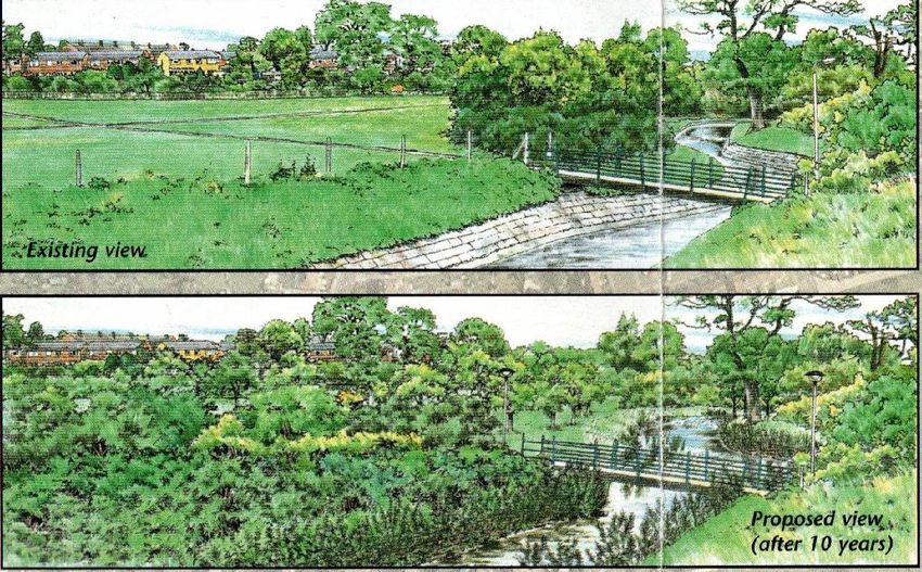
South of Middle Park Way the stream flows through an area now known as
the Hermitage Stream Open Space, where the watercourse has been freed from
its concrete straitjacket. The banks are grassy and gently sloping and there is a
profusion of reeds and rushes. Moreover there are footpaths, benches and
generous amounts of green space on either side, giving an almost rural feel to
this particular part of the Leigh Park estate.
This is probably the most significant improvement that was made as part of
the Hermitage Stream Project, an initiative launched by the Havant Borough
Council in association with the Environment Agency in 1992. Work began in
1995 with an estimated budget of £40-50,000, the work being spread over a
ten year period.
The Hermitage Stream Project was in fact the third of the various schemes to
deal with the stream once the Leigh Park estate had been created.
The first phase, in the early 1950s, was to simply broaden and deepen the
existing channels to cope with the increased run-off that the building of
12several thousand new houses would generate. At the beginning of 1951 the
Hampshire Rivers Board agreed to spend £20,000 on this work.6 Proof that
this was necessary came that autumn when exceptionally heavy rain led to
serious flooding in Chalton Crescent and at Stockheath.7 This work was
completed by the summer of 1953 and a second stage, costing £12,000 was
completed by 1957.8
The second phase took place in the 1970s, when the decision was made to line
the bed and banks of the stream at Leigh lark with concrete and paving. This
reflected the prevailing orthodoxy amongst water engineers at this time that
the best method of dealing with flood water in river systems in urban areas
was to convey it away as quickly as possible, and if this meant turning
watercourses such as the Hermitage into little more than open dams then this
was the price that would have to be paid. In 1973 therefore the Hampshire
Rivers Authority (the successor to the Hampshire River Board) began the
work, with an initial budget of £300,000.9 But however effective this strategy
might have been from a practical point of view its aesthetic impact was
disastrous.
By the 1990s however a different approach had become fashionable. Now,
instead of trying to get rid of flood water as quickly as possible, it was felt
much more desirable to adopt a more natural approach and turn the immediate
environs of the watercourse into a sort of sponge to soak up the excess water
and allow it to be released once the river level had subsided. Hence, on this
part of the Hermitage, the gently sloping grassy banks and the profusion of
reed and other water-loving vegetation. This is a no less effective answer to
the problem but aesthetically, as well as environmentally, it is a huge
improvement.
South of Purbrook Way however the dismal concrete returns, and a little
further downstream, near Priorsdean Crescent, the second major tributary, the
Riders Lane Stream, joins the main river.
13Riders Lane Stream
This begins as a number of small rivulets which drain the largely boggy
ground of Havant Thicket and these would be of little interest save for the fact
that some of them have been utilised to create features in the landscape of the
pre-housing estate Leigh Park.
Leigh Water
By far the most important and well known of these is the lake known as Leigh
Water, which formed the centrepiece of Sir George Staunton's gardens and
around which he arranged many of his statues, monuments and follies. Sir
George's own Notices of the Leigh Park Estate provide an account of the
lake's creation and original appearance that cannot be improved upon:
The Leigh Water is wholly artificial. No accumulation of water
originally existed in this spot; and the floods, which occasionally took
14place after heavy rains, were discharged immediately by the water-
course which traverses the estate. Mr. Garret formed here a small
pond, of a few yards in diameter, for the purposes of watering cattle.
The pond remained in this state until the year 1828, when the
enlargement of it was commenced, upon there being every reason to
expect that the springs and drains from the high grounds within the
Park would afford an adequate supply of water to fill the excavation.
The success of the first experiment led to further enlargements and
embankments and it was finally completed in the present year.[1836]
Not merely content with creating a sheet of water however, Staunton further
embellished it in the following manner:
Three islands have been formed:
1. The Swan Island where the swans are housed.
2. The Cottage Island, upon which is the cottage of an under-gardener who
has charge of this department.
3. The Fort Island, upon which a battery has been built of Purbeck stone,
pierced for nine guns, and displaying on a red pole the Imperial yellow Flag
of China.
There are five bridges on the water:
1. The Chinese Bridge consisting of three brick arches, with Chinese gate-
ways, over which are displayed four inscriptions in Chinese characters, which
may be translated as follows:
Lin chee wha yuen - Thicket water flower garden.
Han fa mei kiao - Chinese style ornamental bridge.
Tsing tsin yeu wan - Please to enter; amused, ramble.
Pin gun jon yee - Health, peace, wishes accomplished.
2. The Corinthian Bridge; a brick bridge, of one arch, surmounted with a
Corinthian Portico, placed across the chief outlet.
3.4.5. Small Bridges - one placed across the inlet from the North; another
across the opening to the Thicket, and a third communicating with the Fort
Island.10
15Today very little of this survives. The islands no longer have their swanneries,
cottages or forts and the only remaining bridge is the one giving access to Fort
Island.
At the south-east corner the stream that feeds the lake (which rises a short
distance away in Hammonds Land Copse) is, for the last few metres, lined
with brick and the remains of a brick weir and a sluice can still be seen. There
are also traces of artificial channels, dug to allow extra rainwater to feed into
the lake nearby.
The outlet is on the western side of the lake and from here the stream flows
south to join the other principal headwater just to the north of Middle Park
Way. Near here, in Thicket Lawn, there used to be another water feature,
described in Staunton's Notices as:
…a spring of pure water, paved and inclosed with iron hurdles. Above it is
the well-known Greek inscription for a font which may be read either
backwards or forwards: – which may be translated: Cleanse thy faults, not
thy face only.11
This, too, has disappeared. A little water still occasionally seeps out from the
foot of the steep slope in High Lawn, but the spring site itself is no more than
a clump of trees, bushes and scrub, with no sign of any enclosure or
inscription. The water now simply drains away into the ground, but the course
of the channel that once conveyed the water from the spring to the stream
draining from Leigh Water can still be seen.
The other feature to be created from a Riders Lane stream headwater is the
Upper Lake, a few hundred metres to the north of Leigh Water. This, however,
was not the work of Sir George Staunton but rather of William Stone after he
had acquired Leigh Park in 1861 and had enclosed Havant Thicket (a lengthy
process begun in 1864 and only fully completed in 1870) which turned it into
his own private playground. It was probably used for swimming, but nobody
would want to swim in it today for it is now a gloomy, forlorn and stagnant
pool to which few walkers or cyclists in the Staunton Country lark probably
pay much attention.
The stream which feeds this pool is one of two that meet on Deerslaughter
16Plain and join the Leigh Water stream just north of Middle Park Way.
It is possible; however, that in the future the whole of this area will be
dramatically transformed if the Portsmouth Water Company's plans to create
the Havant Thicket Winter Storage Reservoir between Warren Park and the
Staunton Country Park go ahead.
Proposed water storage reservoir
The Water Company actually acquired the land (some 160 hectares) as long
ago as 1965, but it was not until 2004 that serious consideration was given to a
proposed reservoir, and by 2008, after consultation with various bodies
including the local Council, the Environment Agency and the Forestry
Commission, the scheme looked likely to go ahead. But then the plans were
shelved, and it is only quite recently that the idea has been revived. At time of
writing (2019) it is intended that the scheme should be completed by 2029) but
as yet no work has been commenced. However some preliminary tree planting
in connection with the reservoir has been carried out.
The aim would be to create a huge reservoir, about one mile east to west and
half a mile north to south, with a capacity of about 8,700 million litres. The
water would be taken from the copious Bedhampton springs, which provide
more than enough to meet current and future anticipated demands, the surplus
at present simply being discharged into the Hermitage Stream. There are also
proposals to landscape the whole area and provide various recreational
activities.
17On the northern side of Middle Park Way is the first flood control point on the
stream, with a debris screen to prevent large objects being carried further
downstream, and having crossed under the road the stream enters Great Copse,
another area of ancient woodland, which has some very fine specimens of
mature trees. Here was located a kitchen garden known as Little Hacketts
which may originally have belonged to a dwelling that pre-dated the very first
Leigh Park house, although the exact location of this building is unknown. Sir
George Staunton decided to create an Arbour here, as a memorial to his
mother, but all traces of this, too, have vanished save for some remnants of a
small single-arch brick bridge which can be seen beneath the modern
footbridge over the stream which has been somewhat prosaically constructed
out of old railway sleepers.12 The banks of the stream are also lined here with
four or five courses of brick – clearly 19th Century – for about ten metres or
so each side of the bridge. The large-scale O.S. map of 1870 also marks a
‘waterfall’ here, but no signs of this can be seen today.
From Great Copse the stream can be followed on foot practically all the way
down to its junction with the main river at Corhampton Crescent. There are
two more flood control points with debris screens along the way, the first on
the north side of Dunsbury Way, the second on the north side of Purbrook
Way. For the last forty or fifty metres of its course the banks are lined with
concrete.
Lower Hermitage
For virtually the whole of the rest of its course the bed and banks of the stream
are once more lined with either brick, concrete or paving, and although it can
be followed by footpaths on both banks as it passes through an area of open
ground between Stockheath Lane and Barncroft Way it is once more of little
aesthetic interest.
Just before it crosses under Barncroft Way can be seen the outfall of the
Lavant Stream Relief Pipe. This was constructed between 1954 and 1962 as
part of a scheme to deal with the occasionally severe problems that can arise
on the nearby Lavant stream in times of exceptionally high rainfall. It has its
opening where the Lavant crosses under Crossland Drive, about 1km. to the
18east. The pipe is 1.37 metres in diameter and can cope with a flow of up to 3
cubic metres per second. The fact that it was now deemed perfectly safe to
deposit such large amounts of water into the Hermitage Stream in an area
(Stockheath) which in the past had been notoriously prone to flooding is
eloquent testimony to how successful the improvement work on the stream
had been in the 1950s. Indeed the stream here flows between generously wide
and deep banks, enabling it to cope with almost any amount of flood water.
The stream then passes under New Road and shortly afterwards takes a
significant diversion to allow it to pass under the Chichester to Portsmouth
railway line at right angles, rather than obliquely, as its natural course would
have done. This work was presumably carried out when the railway was
constructed in 1847.
Immediately south of the railway, between it and West Street bridge, is the
entrance to the Diversion Pipe, constructed by the Portsmouth Water
Company to take the stream away from the springs at Bedhampton Water
Works. This will be dealt with below.
The West Street bridge, known traditionally as the Hermitage Bridge, is a
comparatively modern, utilitarian structure, the latest in what must be a very
long line of bridges carrying the main coast road between Havant and
Cosham, although very little is known about any of the previous ones. Not far
from it, on the north-eastern side, was located the Hermitage from which our
stream derives its name. This was not, however, its original name, for in a
10th Century Charter delineating the boundaries of Havant Parish the stream is
called "ocerburna" (i.e. Ocer stream). The origin of this name is uncertain, but
one thing is clear, it does not, as some have speculated, derive from the word
ochre, meaning reddish-brown. It is true that, after heavy rain, the stream does
often take on a distinctly brownish hue due to the clay that is washed into it,
but ochre is a word of Middle English origin and cannot, therefore, appear in
an Anglo Saxon document. A recent study of the Charter by Susan Kelly has
tentatively suggested that ‘ocer’ could be a corruption of the Old English
‘oter’ (otter) but this is no more than guesswork.
The Hermitage from which the stream derives its modern name was located on
19or near its eastern bank just to the north of the main Havant – Cosham road.
Almost nothing is known about it, although it was certainly in existence by
1496 when Bishop Langton of Winchester granted permission for a hermit
here to receive alms, not only for his own needs, but also to maintain the
upkeep of the bridge. (A similar arrangement existed at Emsworth where the
coast road bridged the River Ems.) It was dedicated to St James – probably St
James the Great as he was the patron saint of pilgrims. It cannot have long
survived the Reformation although ‘Le Harmytage’ is still shown on a map of
Bedhampton dated to circa1580. The name, however, remained attached to the
area (about two acres in extent) long after the Hermitage itself had
disappeared. In a Perambulation of the Bounds of Havant conducted in
September 1520, for example, it is called Hermitage Croft,13 and the name
also appears on the 1861 Census where ‘Hermitage’ is listed as a distinct
district within Havant Parish. It contained just four dwellings, all working
class cottages, with a total of 17 inhabitants. Curiously, however, the name
does not appear on the 1842 Tithe Map where the area is simply a field called
Pasture Piece.
But it must always have been a parcel of land with some significance because
the parish boundary here used to take a very curious course to incorporate it
into Havant rather than Bedhampton, which circumvents it on its western,
northern and eastern sides. The boundary followed the Hermitage Stream
northwards all the way from the estuary at Broadmarsh up past Hermitage
Bridge for a hundred metres or so before turning first east, then south down
Staunton Road (itself an ancient trackway) until it met West Street. It then ran
eastwards along West Street before turning north again at the modern
Boundary Way. That this is an ancient boundary is attested to by the Anglo
Saxon Charter which, although difficult to interpret exactly, does clearly
indicate that the boundary line only deviated from the stream north of the
Hermitage Bridge. This boundary was only altered in the early 20th Century
when the whole of the area on the north side of West Street between Staunton
Road and Boundary Way was transferred from Bedhampton to Havant.
Below Hermitage Bridge the now thoroughly canalised stream passes through
the grounds of the Bedhampton Water Works belonging to the Portsmouth
20Water Company and it is in this area that the stream has caused the most acute
problems.
The Portsmouth Water Company was formed in 1857 and opened its first
Water Works in Brockhampton Road in 1860. Initially it used only the
Brockhampton springs as its source of supply, but even by the 1860s it had
secured the purchase of the two Bedhampton mills, and much of the land
surrounding them, with an eye to utilising the far more copious Bedhampton
springs at a later date. By the 1880s the demand for the Company's water -
which now supplied not only Portsmouth but also Havant, Emsworth and
Cosham - had indeed increased sufficiently to necessitate the construction of
the Bedhampton Works, the first phase of which opened in 1889. But the
immediate proximity of the Hermitage Stream and its unwholesome waters
was a major cause for concern. It must always, to some degree, have been a
convenient dump for all kinds of waste matter, but with so little human
habitation in its immediate vicinity this had not, for most of the time, been a
huge problem. But by the last quarter of the 19th Century housing had begun
to creep ever more closely to it, most especially in the new and rapidly
expanding settlement of Waterlooville but also at the western end of Havant,
with dwellings appearing around the western part of West Street as well as in
Staunton Road and Knox Road. Consequently by the 1880s the stream had
become little more than an open sewer, and it was actually the foul state of the
watercourse which was the catalyst for Havant to acquire – eventually – a
proper comprehensive mains drainage scheme.
Following a serious outbreak of enteric fever in Bedhampton in the autumn of
1895 two army officers garrisoned at Hilsea Barracks, Major Maycock and
Surgeon-Major Porter, decided to conduct their own investigations into the
sanitary conditions surrounding the Bedhampton springs. They were, to say
the least, unimpressed and from the facts that came under their observation
they arrived at the conclusion that there existed a considerable risk of
dangerous pollution of the Portsmouth water supply. Indeed so alarmed were
they that they wrote a report which their superiors at the War Office passed on
to the Local Government Board who, in turn, sent down one of their most
senior officials, Dr. Theodore Thomson, to conduct his own investigations in
21March 1897.
Thomson's Report The Conditions Topographical, Geological and Sanitary of
the Havant Districts (Urban and Rural) and their Relation with the Sources of
the Borough of Portsmouth's Company Water Supply14 which was published
on 14 October 1897 more than confirmed all of Maycock and Porter's
findings.
As to the condition of the Hermitage Stream Thomson wrote:
This stream receives at a point about three miles above the waterworks the
sewage of a considerable part of Waterlooville. Before discharge into the
Hermitage Stream this sewage undergoes no treatment other than passing
through a couple of tanks where some subsidence takes place... it also
receives about 300 yards above the point at which it passes the springs of
the Bedhampton Waterworks the sewage of several houses of that part of
the village of East Bedhampton (sic) through which the stream flows.15
As to the purity of the water in the springs themselves he found, when he
inspected them on 8 March, that, although the water issuing from the spring
known as St Chad's Well was perfectly clear the water in the Blue Hole
collecting basins and in two other collecting basins was observed to be
turbid.16
However he could not be certain whether the discolouration was caused by
pollution from the Hermitage Stream itself or by contaminated ground water.
(The purity of the Brockhampton springs, which were similarly threatened by
the foul state of the Brockhampton Stream, was equally a cause for concern.)
This was by no means the first official enquiry into the sanitary condition of
the Havant area and the possible impact that its polluted watercourses might
have upon the Portsmouth Water Company's supply – indeed Thomson
himself had conducted one just three years earlier – but the impact of all these
enquiries, and the reports that resulted from them had been non-existent.
Havant and Waterlooville remained without mains drainage schemes and their
local politicians – much to the exasperation of the Portsmouth Water
Company and most of its customers – seemed firmly resolved not to provide
them.
22Exactly what the fate of this latest report might have been under normal
circumstances it is impossible to say; but circumstances in the autumn of 1897
were not, by any means, normal, for Britain was in the middle of what was
probably the most serious typhoid epidemic of the entire 19th Century, at
Maidstone in Kent. It had begun in August, and by the time it finally abated in
January 1898 there had been 1910 reported cases and 123 fatalities. But the
worst week of all, with 262 cases and 23 fatalities, was the very week in which
Thomson's Report was published. And the cause of the outbreak? The
pollution of the Maidstone Water Company's supply from chalk springs which
had been contaminated by sewage leaking into them from a nearby hop-
pickers camp. The parallels with the situation at Havant and Bedhampton
could not have been closer.
Thomson's report therefore caused a sensation. The Portsmouth Evening News
deemed it so important that it decided to print it in its entirety over six
consecutive issues from 4 November onwards and declared, in one of several
censorious editorials that:
The grave character of the report cannot be disregarded, and it is evident
that the most important works will have to be undertaken without delay in
order that the purity of the water may be maintained.17
Portsmouth Borough Council was equally alarmed and held an Extraordinary
General Meeting on 2 November to discuss the report during the course of
which one councillor declared that: even as they debated the issue possibly
thousands of our townsmen are being poisoned.18
It is true that more than a decade was to elapse before Havant finally got
mains drainage – and even longer before Waterlooville followed suit – but it
was Thomson's Report, and the events surrounding it, that made their eventual
installation inevitable.
Even before Thomson's report was published however the Portsmouth Water
Company was already well under way to providing its own solution to the
problem of safeguarding the purity of the Bedhampton springs, by the
construction of a five foot diameter pipe to carry the whole of the Hermitage
23Stream underground from a point midway between the railway line and the
Hermitage Bridge to the tidal estuary in Langstone Harbour. (Thomson
himself was aware of this scheme and was confident that it would be a most
effective remedy.)
The Company had had plans for some sort of diversion scheme as early as
1881 and two years later it obtained the necessary legal powers to permit it to
block up the natural course of the stream and divert the water through a pipe.19
But subsequent negotiations with the Havant Urban and Rural Sanitary
Authorities, mainly concerning the purchase of land and questions of
compensation, were both protracted and acrimonious – just one of the many
examples of the long-standing animosity between the Company and the
Havant local authorities – and by 1895 the Company felt compelled to obtain a
new Act of Parliament to give it powers of compulsory purchase of the land
that they required. This, too, was resolutely opposed by the newly-created
Havant Urban and Rural District Councils, and early in February 1896 a
meeting was actually called to discuss the possibility of fighting the
Company's new Bill in Parliament. The resolution to oppose it was carried by
thirteen votes to one, the principle objection to the scheme being that there
would, perhaps, be a hindrance to the drainage of the district.20
But it did little good; the Bill received the Royal Assent in July, and when the
Company held its half-yearly Shareholders' Meeting in November it could be
reported that:
… land is being purchased, and a tender has been accepted for the
execution of the works in connection with the Hermitage Stream. These
works are now in active progress.21
By the time Thomson's Report was published a year later the work was all but
complete, and at the half-yearly Shareholders' Meeting in November 1897 it
could be stated that:
The works in connection with the diversion of the Hermitage Stream are
now finished, and the connections therewith, which have been somewhat
delayed owing to the negotiations respecting the same with the Havant
Rural Sanitary Authority will now very shortly be completed.22
24But in reality the pipe was not, after all, the ideal solution, the main problem
being that it simply was not large enough to cope with the torrent that the
stream could become after heavy rains. There had been concerns raised about
this long before the pipe was even laid – indeed it had been one of the
objections raised at the February 1896 meeting – but the Company, for
whatever reason, chose to ignore them, or at least merely decided to increase
the diameter of the pipe to five feet from the originally proposed four.
The first notable flooding resulting from the pipe's inadequacies seems to have
occurred in May 1903 when, following four inches of rain in just eleven days
the Bedhampton springs were inundated, and only the prompt action of the
Works Engineer prevented this contaminated water from getting into the
public supply. A similar incident occurred in May 1904, although, this time,
the springs themselves were saved from inundation. But the most serious
occurrence took place on 3 January 1906, and the best account of it comes
from the Report written by Portsmouth's Medical Officer of Health Dr.
Mearns Fraser who visited the Waterworks the following day and found most
of the springs polluted and the water quite unfit for public consumption.
The flood was subsiding at the time of my visit and an opening had been
made in the protecting bank to allow the water to escape through the
Company's conduits and so to the sea. The flood was washing through the
works at such a rate that it carried a large portion of the principle road
away and was rushing across the road nearly a foot deep. The springs,
collecting basins and conduits were completely flooded by the Hermitage
Stream, and the rush of surface water that accompanied it.
He returned the following day (5th) and:
By that time the flood had subsided and water was again being pumped
into the town from the Bedhampton works. That is to say, although the
springs were flooded with polluted waters yet within twenty four hours the
water was again being sent to Portsmouth.23
The result was that the water coming out of people's taps for the next few days
was extremely discoloured. This was a state of affairs which Mearns Fraser
(who was a long-standing critic of both the Water Company and the Havant
25local authorities) clearly found astonishing.
The response of the Water Company, however, was simply to dig a relief
channel parallel to the pipe to convey away any water that the pipe could not
cope with in times of flood. This did, however, appear to work quite well, and
no other inundation of the springs seems to have occurred thereafter.
The condition of the Hermitage Stream did not improve until after 1910 when
Havant at last acquired a proper comprehensive mains drainage system
(Waterlooville acquired one a short time afterwards) but the problem of
pollution did not entirely disappear even then. As late as 1930 eighteen cases
of enteric fever were recorded amongst children who had drunk water from
the Hermitage Stream in Stakes Wood which had been polluted by a leakage
from the Waterlooville Sewage Works (then located on the north side of
Hulbert Road opposite the cemetery). It was an incident deemed serious
enough to be raised at the Annual Conference of the British Waterworks
Association in Belfast the following year.24
It was only in the 1950s, after the extensive work to broaden, deepen and
canalise the channel between the pipe entrance and the waterworks had been
carried out, that it was deemed safe enough to restore the Hermitage Stream to
its original course, retaining the pipe merely as a safety valve to take away
excess water – a function it fulfils to this day. Fortunately the possibility of the
Bedhampton springs being contaminated by the Hermitage Stream is now very
remote indeed.
It is only when the stream has reached the Waterworks grounds and received
the overflow from the springs that it returns, albeit briefly, to its natural
condition. It then flows first past the waterworks and then the Mill Pond that
belonged to the now vanished Bedhampton Lower Mill. Here it receives,
although only indirectly, its only significant tributary, a watercourse known
either as the Bedhampton Stream or the Brookside Road Stream.
This has its source in the chalk springs that emerge from the foot of Portsdown
Hill to the north of Belmont Castle. It then flows due east along the foot of the
chalk ridge, crossing under the A3M in a culvert, turning south and then re-
appearing briefly at the junction of Portsdown View and Brooklands Road. It
26then disappears once more into a culvert which runs under Brooklands Road,
Maylands Road and Brookside Road. Originally there was just one pipe to
carry the water, but this did not prove adequate to deal with floods (caused in
part by increased surface run-off as a consequence of ever-expanding
urbanisation) and a second pipe had to be laid. Subsequently a third pipe was
added as well to create additional capacity as far as Penhurst Road. The stream
re-emerges half way down Brookside Road, flowing in an open channel
between the east side of the roadway and the houses. It then crosses under
Bidbury Lane, after which it splits into two (although one of these channels is
artificial) and flows across a piece of open ground before re-uniting and
crossing under first Mill Lane and then the railway line. It then empties into
the Mill Pond and the overflow from this pond (comprising mainly of more
surplus water from the Bedhampton springs) then feeds into the Hermitage
Stream.
Considerably swelled by this new intake of water the Hermitage Stream then
passes underneath the Havant bypass, after which the banks are once more
lined with paving. Just below the bypass bridge can be seen the outfall of the
diversion pipe and beyond this is the bridge carrying Harts Farm Way.
The stream finishes its course by discharging into Langstone Harbour on the
western side of the quay where the ships dredging the bed of the Solent for
sand and gravel unload their hauls.
This is scarcely a memorable end to the stream's journey. Indeed along the
whole of its course there is very little that can be said to be either memorable
or beautiful, and in all too many cases it and its environs are distinctly
mundane – or worse. In consequence few of the tens of thousands of people
who live in its catchment area probably pay it very much attention and even
fewer – if any – regard it with the slightest degree of affection. But if it is not a
loveable stream it is a far from negligible one, and for a watercourse of such
modest size it demonstrates an extraordinary variety of features that must be
of interest to anyone who wishes to understand the local landscape and the
impact that human habitation has had upon it.
27Notes
1 For Gilbert see Derek Gladwyn Leigh Park: A Nineteenth Century Pleasure
Ground p. 179-81
2 James King A Poem On Leigh Park (1829)
3 Portsmouth Evening News 5 Nov. 1955
4 Steve Jones The Early Years of Waterlooville: 1810-1910 p.38-39
5 John Pile A Note on Two Medieval Fish Ponds at Bedhampton Hampshire Field
Club Newsletter: New Series 13. Spring 1990. p.14-15
6 Portsmouth Evening News 10 Feb. 1951
7 Portsmouth Evening News 19 Nov. 1951
8 Hampshire Telegraph 8 Feb. 1957
9 Hampshire Rivers Authority Annual Report 1973 p.21 (Hampshire County
Records Office 11A05/A2)
10 Notices of the Leigh Park Estate, Near Havant (1836). Reprinted
in Steve Jones Leigh Park Estate: Garden Features and Follies p.28.
11 Ibid, p.27
12 Steve Jones Leigh Park Estate: Garden Features and Follies p.40-42
13 Charles Longcroft 'Hundred of Bosmere' (1,57) p.27-30
14 Portsmouth Evening News 4 Nov. 1897. The springs, of course, supplied the
water for their own barracks at Hilsea
15 Report p.7-8
16 Ibid. p.12
17 Portsmouth Evening News 15 Oct. 1897
18 Portsmouth Evening News 3. Nov. 1897
19 Under the Portsmouth Water Company Act (1883). Portsmouth Water
Company Archive 129A/S6/6. (Portsmouth History Centre)
20 Hampshire Telegraph 8 Feb. 1896
21 Hampshire Telegraph 21 Nov. 1896
22 Portsmouth Evening News 16 Nov. 1897
23 Report Presented to the Health Committee of the Portsmouth Borough Council.
Minutes for 1906 p.127-28. (Portsmouth History Centre). From which the
information about the 1903 and 1904 floods is also derived.
24 Belfast News Letter 23 July 1931
28Hermitage Stream Catchment Area
TOPOGRAPHY – The Hermitage Stream catchment of 19 square km.
comprises mainly Tertiary deposits of London Clay and Reading Beds
with some Upper Chalk outcropping on the coast. The area extends from
the Queens Inclosure and Havant Thicket in the north to Langstone
Harbour in the south. The Hermitage Stream catchment includes three
branches, being the Park Lane Stream, the Riders Lane Stream, and the
geographically separate Brookside Road stream at Bedhampton (which
serves the eastern end of Portsdown Hill).
Environment Agency Main Rivers
HERMITAGE STREAM - The head of the main river is at the point where
the Stream leaves the Queens Inclosure in Cowplain. This watercourse is
the source of the Hermitage Stream and has its head in the Queens
Inclosure at Cowplain, fed by sources now subsumed within the public
surface water sewerage system of the Padnell estate. This heavily wooded
area has altered little in the last three decades except for its increased
usage by the public as a recreation and amenity area.
The stream runs from east to west along the southern edge of the
Inclosure and acts as a natural barrier between the woodland and the
developed areas to the south. Where it turns south at Highfield Avenue it
is joined by a minor watercourse from Park Wood. Continuing
southwards, the watercourses runs through a natural steep sided valley
leading to the Hulbert Road, partly culverted at beneath the dual
carriageway section of this major transport corridor. Approximately 80%
of this area is now developed and almost all of the existing woodland has
been lost. There are various groundwater and land drainage problems of
a minor nature associated with the local geology, terrain, and interruption
of the natural land drainage due to the development of the area which
gives rise to flooding from springs and groundwater movement.
An improvement scheme up to Ramsdale Avenue in Leigh Park was
completed in 1977 to allow for an in bank flow of up to 24 cumecs (at the
down-stream end). The improvement scheme consisted of the
construction of some 820 metres of earth channel, 3.2 kilometres of
concrete lined channel with bank revetment in concrete blocks, various
alterations and additions to highway and private bridges and structures,
and the provision of an additional culvert under the Portsmouth - Havant
29railway line. The channel is designed to take predicted 1 in 50 year
catchment flows. The lower reaches (below Barncroft Way) are also
designed to accept a transferred flow of up to 3 cumecs from the
adjoining catchment's main river, the Lavant, via the pipe link from
Crossland Drive.
The Environment Agency recalculated the Hermitage Stream catchment
in 1998, and the results were used when redesigning the central reach of
the river through Leigh Park (between the Riders Lane stream confluence
and Middle Park Way) as a natural open channel. This was completed in
1999 in a project jointly funded by HBC and the Environment Agency.
Environment Agency Telemetry – to give early warning of potential
flood events caused by blocked / obstructed river grillages, the
Environment Agency monitors water level on the Hermitage Stream
upstream of the New Road bridge
PARK LANE STREAM – This main river originally had its source at
Padnell Cuts Wood, now the Hazleton Way Estate. The stream passes
through a natural valley running under the A3M and south to Blendworth
Common and The Warren, from where it is enmained. Its lower reaches
are culverted through St Clares Avenue open space, Sunwood Road and
Overton Crescent before issuing into the Hermitage Stream just
downstream of Middle Park Way. The watercourse drains the housing
conurbation of the Warren and the western area of Leigh Park.
Havant Borough Council purchased St Clares open space (which
includes the Warren) from Portsmouth City Council in April 1992 and so
became the responsible landowner of the watercourse between Woolston
Road and the Warren Dam. This transferred to the Environment Agency
upon the enmainment of the Stream in 2005. They carry out a programme
of planned maintenance to meet its land drainage obligations to provide
for the free flow of water in the stream and to clear the grill protecting the
entrance to the Dam.
At the foot of the open section lies the 'Giant Steps' area, named after the
now-removed Warren Dam. This was a set of weirs with a flow control
penstock. This structure was removed by the Environment Agency in
2009, although the replacement land form and grillage arrangements
provides an equivalent level of flood protection. The culverted section of
watercourse downstream of the Dam remains in the ownership of
Portsmouth City Council, until it reaches Middle Park Way and ultimately
30outfalls to the Hermitage Stream.
RESERVOIRS ACT 1975 – THE WARREN DAM – This structure was
designed to control the discharge of flood waters from the northern part
of the catchment into the culverted section south of St Clares open space,
and comprised an earth embankment with weirs, through which passed a
culvert controlled by a penstock gate. Due to the amount of water it could
impound, annual inspections as required under Section 10 of the
Reservoirs Act 1975 were required.
Due to considerable vandalism and dereliction to the weir during the
late 1990s, the penstock winding gear was been removed and the
penstock itself was fixed half open to control the down-stream flow.
Maintenance work in 2002 and 2003 resulted in an easier to maintain
structure. Inspection of the dam passed to the Environment Agency upon
enmainment in 2005, and they brought forward proposals to remove it
and replace it with a much more open landform, whilst still providing the
same flood protection to neighbouring properties.
RIDERS LANE STREAM – This main river has its head in a fan of minor
issues between the Avenue, Longwood and Furzy Plain within Havant
Thicket, and Hammond Hands Copse to the east of Leigh Park Lake
(Staunton Country Park). The two main arms of these sub-tributaries join
just north of Middle Park Way (from where the main river designation
starts, since 2005) flowing south and west through Great Copse to
Dunsbury Way, then south and east via Riders Lane / Purbrook Way to
join the Hermitage Stream at Corhampton Crescent.
There are persistent problems associated with the grills protecting the
culverts under Middle Park Way, Dunsbury Way and Purbrook Way
which require a programme of regular cleansing by the Environment
Agency. This problem is especially acute in the autumn if the heavy leaf
fall associated with the indigenous hard wood trees is accompanied by
periods of heavy rainfall. In particular the blinding of the triple grills
protecting the triple 24 inch diameter culverts at Purbrook Way causes
flooding of the adjoining highway, even though a realignment of the
stream including a flood retention area were provided north of Purbrook
Way at Riders Lane open space in 1983. A possible long-term solution to
this problem could be to increase the capacity of the culvert under
Purbrook Way to a size which would include for the removal of the grills.
This would have to be carried out along with improvements to the down-
31stream section of the Riders Lane Stream between Purbrook Way and the
Hermitage Stream to ensure that there would be adequate provision for
any increased flow.
Flooding can also occur upstream of the brick arched bridges in the
northern part of Great Copse and adjoining Dunsbury Way (the latter
causing overtopping and closure of Dunsbury Way on a number of
occasions on 2000/1), and at the southern end of Great Copse where an
undersized culvert provides a vehicular and pedestrian access across the
stream from High Lawn Way.
The headwaters of this Stream are likely to be incorporated into the
proposed Havant Thicket Reservoir currently being promoted by
Portsmouth Water Company on land north of Middle Park Way.
Riders Stream grill at Dunsbury Way – clear – blocked and resultant flood
32Riders Stream grill at Purbrook Way
Grill blocked with flow going across Purbrook Way - but fun for the kids!
33BROOKSIDE ROAD STREAM – This main river has its source in the
syncline valley to the north east of Portsdown Hill in an area of Upper
Chalk deposits the remainder being predominantly London Clay. The
open downland falls steeply to the east crossing under the A3M – where
the main river designation starts – and on to Brooklands Road where it
enters culverts which outfall at Brookside Road. The original stream no
longer exists between Brooklands Road and Brookside Road, having been
enlarged and piped to deal with the increased flows generated by the
urbanisation of the area. Although the original pipe was designed to take
the combined flows of both the adjoining housing conurbation and the
stream it was necessary to duplicate it for part of its length in an attempt
to alleviate flooding to property in Brooklands Road and Brookside Road.
From Brookside Road the stream continues in open channel south under
Bidbury Lane and then separates into two branches as it crosses open
land, one being the original stream and the other a man-made irrigation
ditch controlled by a private sluice gate. Rejoining north of the railway the
stream is culverted under the railway and Mill Lane issuing in Portsmouth
Water Company land where it joins the Hermitage Stream at the Old Mill
Dam.
ORDINARY WATERCOURSES – These are the responsibility of their
landowners. In the late spring and autumn the ordinary watercourses of
the catchment tend to become choked as a result of prolific weed growth.
This can lead to flooding of adjoining land and property if they are not cut
back on a regular annual basis in the spring and autumn. The situation
can become further exacerbated in the autumn by the heavy leaf fall
associated with the indigenous hardwood trees that remain on the routes
of the ordinary watercourses and especially in the heavily wooded areas.
On certain reaches deliberate obstruction of the watercourse is
experienced.
HAVANT BOROUGH COUNCIL RIPARIAN OWNERSHIP – The Borough
currently owns the St Clare’s open space which it purchased from
Portsmouth City Council in April 1992 and has a budget to meet its
riparian obligations.
34You can also read


