Best Practices 3D Cadastres - FIG REPORT - 3D Cadastre Joint Working Group Commission 3 and Commission 7 - GDMC
←
→
Page content transcription
If your browser does not render page correctly, please read the page content below
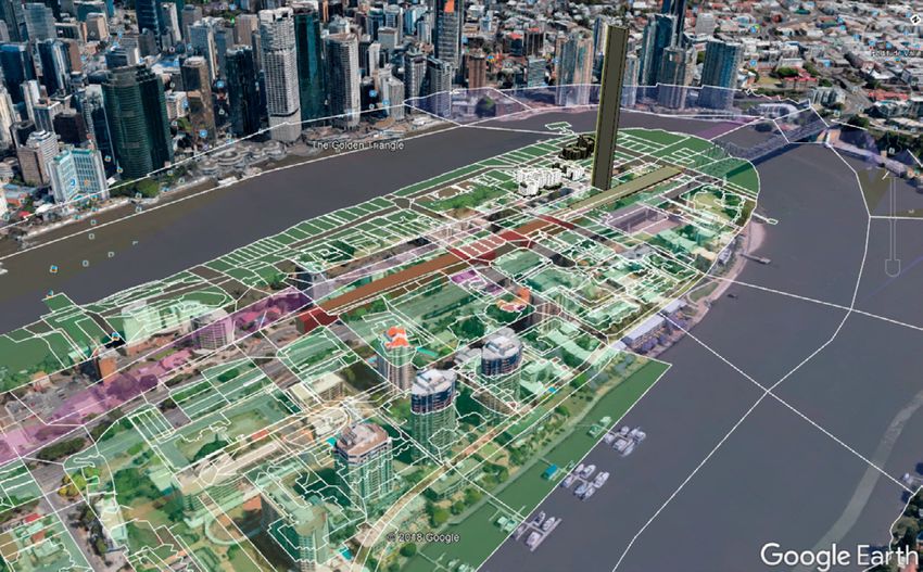
FIG REPORT

FIG Publication
     No 72

             Best Practices 3D Cadastres

      3D Cadastre Joint Working Group Commission 3 and Commission 7

                              INTERNATIONAL FEDERATION
                                  OF SURVEYORS (FIG)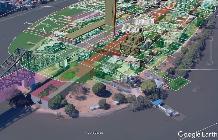
Best Practices 3D Cadastres

    3D Cadastre Joint Working Group
    Commission 3 and Commission 7

       Editor: Peter van Oosterom

INTERNATIONAL FEDERATION OF SURVEYORS (FIG)
The front and the back cover illustrations show screenshots of the prototype of a web-
based 3D Cadastre dissemination system built on top of Google Earth. The cadastral
parcels are elevated 50 meters in order to visualize the relationship with the topog-
raphy. The 2D parcels (from the DCDB) are draped over a terrain elevation model, the
building format Survey Plans are converted into 3D parcels (property units in building),
the volumetric format Survey Plans are also converted 3D parcels and correspond to
various types of objects: below (tunnel parts), above (property under ramp to bridge),
and through the earth surface (air shaft).
Front cover: looking from the South-East towards Kangaroo point (Brisbane, Queens-
land), note the correspondences between the cadastral objects and the topographic
objects, 50 meters below.
Back cover: looking from the North-West towards Kangaroo point, note the reddish
volumetric parcels (tunnel parts) bellow the semi-transparent greenish surface parcel,
a bit further inland many greyish 3D parcels from building format Survey Plans (some
with black, some with white edges).
Queensland Digital Cadastral Database (DCDB) data and Survey Plan data provided by
Sudarshan Karki (Queensland Government, Department of Natural Resources, Mines
and Water), the terrain elevation model provided by Martin Kodde (Fugro) / Glen Ross-
Sampson (Roames), conversion from building format and volumetric format Survey
Plans, and draping of 2D parcels over terrain elevation model by Rod Thompson (in the
context of the on-going 3D Cadastral visualization project with Barbara Cemellini, Mar-
ian de Vries, and Peter van Oosterom, TU Delft).

Copyright © The International Federation of Surveyors (FIG), November 2018.
All rights reserved.
International Federation of Surveyors (FIG)
Kalvebod Brygge 31–33
DK-1780 Copenhagen V
DENMARK
Tel. + 45 38 86 10 81
E-mail: FIG@FIG.net
www.fig.net
Published in English
Copenhagen, Denmark
ISSN 1018-6530 (printed)
ISSN 2311-8423 (pdf )
ISBN 978-87-92853-83-7 (printed)
ISBN 978-87-92853-84-4 (pdf )
Published by
International Federation of Surveyors (FIG)
Layout: Lagarto
Printer: 2019 LaserTryk.dk A/S, Copenhagen, Denmark
CONTENT

PREFACE....................................................................................................................... 5
      Chryssy Potsiou

INTRODUCTION .......................................................................................................... 7
      Peter van Oosterom

CHAPTER 1: Legal foundations.......................................................................... 9
      Dimitrios Kitsakis, Jesper Paasch, Jenny Paulsson, Gerhard Navratil, Nikola Vučić,
      Marcin Karabin, Mohamed El-Mekawy, Mila Koeva, Karel Janečka, Diego Erba,
      Ramiro Alberdi, Mohsen Kalantari, Zhixuan Yang, Jacynthe Pouliot, Francis Roy,
      Monica Montero, Adrian Alvarado, and Sudarshan Karki
      1.1     Introduction............................................................................................................................. 9
      1.2     3D Legal Issues Exemplified by Case Studies.............................................................11
      1.3     Discussion and Comparison.............................................................................................11
      1.4     Conclusions............................................................................................................................17
      1.5     Further Research..................................................................................................................17

Chapter 2: Initial Registration of 3D Parcels........................................... 19
      Efi Dimopoulou, Sudarshan Karki, Miodrag Roić, José-Paulo Duarte de Almeida,
      Charisse Griffith-Charles, Rod Thompson, Shen Ying, Jesper Paasch, and Peter
      van Oosterom
      2.1     Introduction...........................................................................................................................19
      2.2     Current Status of 3D Registration...................................................................................21
      2.3     Legal and Technical Issues................................................................................................22
      2.4     Conclusions and Future Trends.......................................................................................26

CHAPTER 3: 3D Cadastral Information Modelling................................... 29
      Peter van Oosterom, Christiaan Lemmen, Rod Thompson, Karel Janečka,
      Sisi Zlatanova, and Mohsen Kalantari
      3.1     Introduction ..........................................................................................................................29
      3.2     Modelling Requirements...................................................................................................30
      3.3     Standardized Information Models.................................................................................34
      3.4     Conclusion..............................................................................................................................34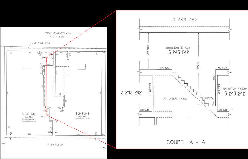
CHAPTER 4: 3D Spatial DBMS for 3D Cadastres............................................ 39
Karel Janečka, Sudarshan Karki, Peter van Oosterom, Sisi Zlatanova, Mohsen
Kalantari, and Tarun Ghawana
4.1 Introduction...........................................................................................................................39
4.2 Aspects of 3D Spatial DBMS for 3D Cadastres...........................................................40
4.3 Challenges and Research Opportunities in 3D Spatial Database
Management Systems for 3D Cadastre .......................................................................41
4.4 Conclusions............................................................................................................................44
CHAPTER 5: Visualization and New Opportunities.................................... 47
Jacynthe Pouliot, Claire Ellul, Frédéric Hubert, Chen Wang, Abbas Rajabifard,
Mohsen Kalantari, Davood Shojaei, Behnam Atazadeh, Peter van Oosterom,
Marian de Vries, and Shen Ying
5.1 Introduction...........................................................................................................................47
5.2 Understanding 3D Visualization.....................................................................................48
5.3 Benefits of 3D Cadastre Visualization...........................................................................49
5.4 Challenges and Research Opportunities in 3D Cadastre Visualization............52
REFERENCES.............................................................................................................. 56
BIOGRAPHICAL NOTES AND CONTACT DETAILS.................................................. 64
4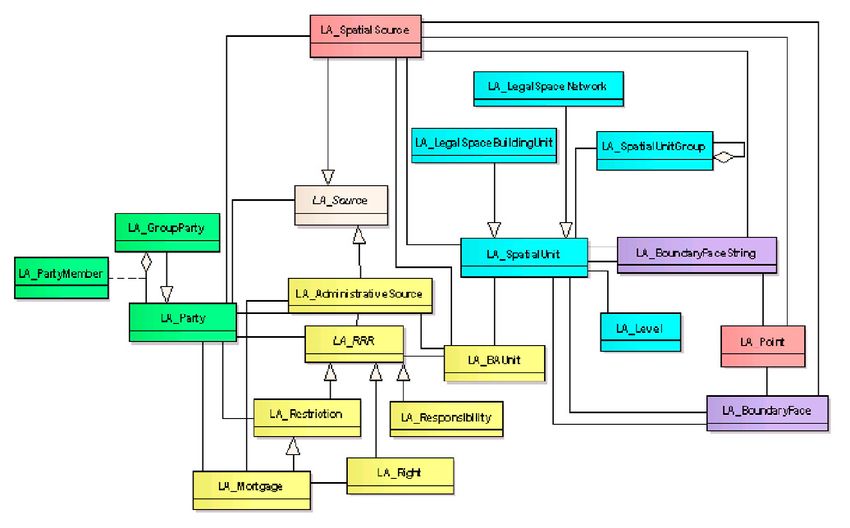
PREFACE

Over the last 15 years or so, a number of political, economic, environmental and social
factors as well as the rapid technological innovation have profoundly changed the out-
look for good management of land, the sea and especially the built environment. In
this context, the issue of security of tenure and registration of property rights is recog-
nized as an increasingly important component for eliminating poverty and achieving
sustainable development of land, real estate and property markets in all UN member
states, particularly in urban areas.
In view of the Sustainable Development Agenda 2030 all UN member states are de-
veloping and modernizing their cadastre and land registration systems and in parallel
formalizing their property markets. Present land administration systems and cadastres
need re-engineering; they must continually evolve to cope with the ongoing meg-
atrends, such as urbanization, demographic change, societal disparities, the digital
transformation, volatile global economy, anthropogenic environmental damage and
so on.
Much of the current research by the surveying profession in this field focuses on issues
related to 3D geo-information, tools for data collection, cloud solutions, data manage-
ment, optimizing processes and web-based information dissemination; standardiza-
tion of 3D information, advanced modelling and visualization, as well as formalizing
and building sustainable real estate markets as a pillar for robust economic urban
growth; and related policies, legal and institutional aspects and knowledge sharing in
operational experiences, the emerging challenges and the good practices. The signifi-
cance of these areas of interest for the good management of land, the sea and espe-
cially the built environment is well understood.
It is mainly about people and their living in urban settlements. It is mainly about de-
veloping the “cities we want”, digitally networked and intelligent. And we, as geo-infor-
mation professionals, vendors, providers, managers, professionals as well as academics
and researchers, are expected to develop services and tools to deliver administrative,
economic and social benefits. Our colleagues, representatives of business, academia
and public administration; managers of geodata from all over the world; young entre-
preneurs and creative minds; all are working toward the same goal, trying to increase
the “value” of geodata for the people. They do so in order to get more benefit, more
transparency, more safety, more environmental quality, more growth, more fairness,
more efficiency in governance of urban areas, more smart cities.
No reality has a more direct bearing on the subject of 3 dimensional geo-information
and cadaster than the growth of large cities, especially in the developing countries of
the world, and especially in the phenomenon of the mega cities. For our young read-
ers let me give some impressive information. A mega city is an urban area of 10 million
population or more. The Economist “Pocket World in Figures” 2016 Edition, lists thirty-
three mega cities of the world from Bangalore, India at ten point one million, thirty-
third on the list, to number one Tokyo at thirty-eight million.
The World Health Organization (WHO) has reported that in 2014 fifty-four percent of
the world’s people lived in urban areas, up from thirty-four percent in 1960. The tipping
point, according to most authorities, occurred in 2007 when there were more urban
dwellers than rural residents in the world: the so-called “urban millennium.”

                                            5
The United Nations predict that by 2050 sixty-six percent of the world’s population will
live in urban areas.
Much is being written about the growth of urban populations and the concurrent
growth of urban infrastructures and institutions to support this huge growth of two-
thirds of the world’s people in the cities. Of all the institutions that must be developed
to anticipate, keep abreast of and support this growth, the cadaster stands foremost
in the interest of commerce, real estate investment, municipal revenue, and personal
property security, not to mention urban planning and management.
As the cities grow they grow vertically as well as horizontally thereby introducing the
element of the third dimension.
Recent innovative thinking has introduced the concept of a multi-dimensional multi-
purpose land information system. It is a logical extension of the 3D cadaster concept,
by adding the time dimension and the detail/scale dimension to the equation.
In a discussion of “cost effectiveness” one must consider time, that 4th dimension that
we speak of. In time, we are usually referring to land titles history and time-sharing
rights, or how the shape and size of land parcels and cadastral objects change over
time, but it is also a matter of time-cost in the construction of the cadaster, as well as
the time/property value relationship. As the great cities of the world become mega,
the value of land and its improvements grow as well. Thus the time/value relationship
and its impact on land administration and the need for continuing research on fun-
damental policy issues of technical administrative, legal and financial aspects of land
administration.
This publication is a further contribution of FIG in this on-going process of improving
land administration systems. It responds to the need for international research in build-
ing effective land administration infrastructures with modern information technology
that will support the 2030 global policy goals for sustainable development. This study
takes into account the recent developments that have taken place, and I hope that it
will lead to a better understanding of the concept of a 3D cadaster.

Prof Chryssy A Potsiou
President of FIG

                                            6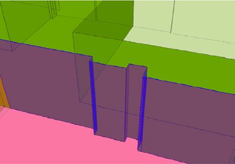
INTRODUCTION
At the end of the two most recent 4-year terms (2010-2014 and 2014-2018) of the joint
commission 3 ‘Spatial Information Management’ and commission 7 ‘Cadastre and Land
Management’ FIG Working Group on 3D Cadastres, it was decided to collect the best
known practices in a single FIG publication. Key authors were invited to lead a chapter
on one of the following topics:
   •   Chapter 1. Legal foundations (Dimitrios Kitsakis),
   •   Chapter 2. Initial Registration of 3D Parcels (Efi Dimopoulou),
   •   Chapter 3. 3D Cadastral Information Modelling (Peter van Oosterom),
   •   Chapter 4. 3D Spatial DBMS for 3D Cadastres (Karel Janečka), and
   •   Chapter 5. Visualization and New Opportunities (Jacynthe Pouliot).
The mentioned lead authors have each teamed-up with a group of authors to produce
their chapters. A lot of inspiration was found in the earlier 3D Cadastres activities of FIG,
such as the various 3D Cadastres workshops, the two 3D Cadastres questionnaires, and
the presentations and publications at the 3D Cadastres sessions at every FIG Working
Week and Congress. The result is a quite extensive FIG publication of about 250 pages,
which has been language checked by native English speakers.
Based on the long version (available at http://www.gdmc.nl/3DCadastres/FIG_3DCad.
pdf ) this shorter version of about 80 pages is produced. The short version is available as
FIG publication both in hard-copy (paper) and soft-copy (pdf online). The long version
will only be published in soft-copy form and in the style of the FIG proceedings.
The FIG publication ‘3D Cadastres Best Practices’ has quite a long history. Many 3D Ca-
dastral activities have been conducted during the past two decades: six FIG 3D Cadastres
workshops, sessions at FIG working weeks and congresses, three special issues in interna-
tional scientific journals, several 4-year terms (2004-2008, 2010-2014 and 2014-2018) of
the joint commission 3 and commission 7 FIG Working Group on 3D Cadastres, and two
questionnaires (2010 and 2014). Closely related to these workshop are the special issues
of international scientific journals. Three times the initiative was taken to invite selected
authors, based on review of full workshop papers and presentations / discussions at the
workshop, to submit a significantly extended / changed version to the special issue. After
submitting, the paper has gone through the peer review process of the journal. This re-
sulted in the following three special issues as indicated by their introductions/editorials:
   •   Christiaan Lemmen and Peter van Oosterom (2002). 3D Cadastres, In: Computers,
       Environment and Urban Systems, 27, 337–343.
   •   Peter van Oosterom (2013). Research and development in 3D Cadastres, In: Com-
       puters, Environment and Urban Systems, 40, 1-6.
   •   Peter van Oosterom and Efi Dimopoulou (2018). Research and Development Pro-
       gress in 3D Cadastral Systems. In: ISPRS International Journal of Geo-Information,
       7(2), 5.
The first more concrete versions of texts towards the FIG publication ‘3D Cadastres Best
Practices’ was in the form of four overview reports, each presented at the “5th Interna-
tional FIG Workshop on 3D Cadastres”, organized in Athens, Greece, 18–20 October 2016:
   1. Dimitrios Kitsakis, Jesper Paasch, Jenny Paulsson, Gerhard Navratil, Nikola Vucic,
      Marcin Karabin, Andréa Flávia Tenório Carneiro and Mohamed El-Mekawy: 3D

                                              7
Real Property Legal Concepts and Cadastre: A Comparative Study of Selected
       Countries to Propose a Way Forward.
   2. Efi Dimopoulou, Sudarshan Karki, Roic Miodrag, José-Paulo Duarte de Almeida,
      Charisse Griffith-Charles, Rod Thompson, Shen Ying and Peter van Oosterom:
      Initial Registration of 3D Parcels.
   3. Karel Janecka and Sudarshan Karki: 3D Data Management.
   4. Jacynthe Pouliot, Frédéric Hubert, Chen Wang, Claire Ellul and Abbas Rajabifard:
      3D Cadastre Visualization: Recent Progress and Future Directions.
Discussions during and after the 2016 Workshop resulted in the decision to split Chapter 3
into two parts: one on information modelling and one on data management. The author
teams were further reinforced and each produced a next version of their chapters, which
were reviewed by colleagues from other author teams. These actions were conducted be-
fore the FIG Working Week, Helsinki, Finland, 29 May – 2 June 2017 and discussed at the
working week by representatives of each of the chapters. The review comments were pro-
cessed in the second half of 2017 by the authors teams and all chapters were proof read by
native English speakers and finally edited to get an uniform style.
The FIG publication ‘3D Cadastres Best Practices’ hopes to provide a clear and compre-
hensive overview to both the newcomers and experts in the 3D Cadastres community.
For sure this is just a snapshot of the current state and our knowledge must further evolve
with the many challenges that are ahead of us, including the emerging mega-cities due
to further urbanization. Many developments are ahead of us and to name just a few: revi-
sion of LADM (with potentially more detailed 3D spatial profiles), Marine Cadastre, deep
integration of 3D space and time (4D Cadastre), new data acquisition techniques (includ-
ing VGI), growing information infrastructure (of which Land Administration is a part), and
new visualization and dissemination techniques (including VR and AR). Already, the next
step of our on-going journey is planned: the 6th International FIG Workshop on 3D Cadas-
tres, to be organized in Delft, The Netherlands, 2–4 October 2018. And also this time a spe-
cial issue on 3D Cadastres is planned: to be published in Land Use Policy (2019 or 2020).
It was a great pleasure to be involved in the creation of the FIG publication ‘3D Cadas-
tres Best Practices’. This was mainly due to the constructive and open collaborations of
all involved. First of all I would like to thank the lead authors, the authors of chapters in
the publication, but also the authors of papers at past FIG 3D Cadastres workshops and
other FIG events, for their continuous contributions to the field of 3D Cadastres. Next, it
is important to remember the hard work the reviewers (programme committees mem-
bers) have put into all their constructive comments and adding many ideas and views
to those of the original authors. Many, many thanks for this often rather invisible task.
Finally, I would like to thank Sudarshan Karki for the English proof reading of an incred-
ible amount of pages and Dirk Dubbeling for the last checks and formatting to make
sure the publication gets an uniform look and feel. Great teamwork, thanks for the many
years of collaborations.

Prof Peter van Oosterom
Chair of the FIG 3D working group on 3D Cadastres
CHAPTER 1: Legal foundations
Dimitrios Kitsakis, Jesper Paasch, Jenny Paulsson, Gerhard Navratil, Nikola Vučić,
Marcin Karabin, Mohamed El-Mekawy, Mila Koeva, Karel Janečka, Diego Erba,
Ramiro Alberdi, Mohsen Kalantari, Zhixuan Yang, Jacynthe Pouliot, Francis Roy,
Monica Montero, Adrian Alvarado, and Sudarshan Karki
1.1 Introduction
The concepts of three-dimensional (3D) real property have been the subject of in-
creased interest in land use management and research since the late ‘90s while litera-
ture provides various examples of extensive research towards 3D Cadastres as well as
already implementing 3D cadastral systems. However, in most countries the legal as-
pects of 3D real property and its incorporation into 3D cadastral systems have not been
so rigorously examined.
This chapter compares and discusses 3D property concepts in fifteen selected coun-
tries, based on the authors’ national experience, covering Europe, North and Latin
America, Middle East and Australia. Each of these countries’ legal system is based on
different origins of Civil Law, including German, Napoleonic and Scandinavian Civil
Law, which can prove useful to research in other Civil Law jurisdictions interested in in-
troducing 3D cadastral systems. Selected countries are on different stages of introduc-
ing and implementing a 3D cadastral system; this may contribute to the detection of
the main 3D real property concepts that apply as well as deficiencies and malfunctions
that prohibit introduction of 3D cadastral systems, highlighting challenges that may
have not yet surfaced. This chapter aims to present the different legal concepts regard-
ing 3D real property in the examined countries, focusing on the characteristic features
of cadastral objects described as 3D within each country’s legal and cadastral frame-
work. The analysis of the case studies revealed that the countries are on different stages
of 3D Cadastre implementation, starting from countries with operational 3D cadastral
systems, to others where there is yet no interest in introducing a 3D cadastral system.
3D cadastral objects in each country are presented, as well as differences in the regu-
latory framework regarding definition, description and registration. The chapter con-
tinues the legal workshop discussions of the 4th International Workshop on 3D Ca-
dastres in Dubai 2014 by analysing the legal concepts of 3D cadastres in the above-
mentioned countries. The outcome is an overview and discussion of existing concepts
of 3D property describing their similarities and differences in use, focusing on the legal
framework of 3D cadastres. The article concludes by presenting a possible way forward
and identifies what further research is needed which can be used to draft national and
international research proposals and form legislative amendments towards introduc-
tion of national 3D cadastral systems. Cadastres are being recognized as the core of
land administration systems. The cadastral map should be able to represent complete
and comprehensive spatial information for registering land rights, restrictions and re-
sponsibilities (RRRs) on the land parcels (Kaufmann and Steudler, 1998). However, until
today most of the countries around the world use 2D land parcels as the base for their
land administration systems (Ho et al., 2015), regardless of the 3D characteristics im-
plied by the relative real property legislation. Thus 2D projectional presentation of RRRs
on land parcels cannot accommodate complex, overlapping real property so it needs
9to be extended to three-dimensional (3D) space and properties. Controversy between
3D real property implications in legislation and its 2D registration and documentation
is becoming more emphasized with the increasing development of urban areas with
complex structures, high-rise buildings and underground infrastructures. The rights of
cadastral objects may relate to spaces above or below the Earth’s surface (Stoter et al.,
2011). More complex relationships in space can no longer be unambiguously mapped
onto the Earth’s surface in 2D. Pressure on the land use, especially in the city centres,
has led to dense construction with complex structures with intertwined relationships.
In general, registration of rights is possible on parts of the building. However, the spatial
representation of the extension of rights often does not exist or it is possibly stratified
on two-dimensional representation. In addition, an increasing number of tunnels, un-
derground networks and infrastructure objects (e.g. water, gas, electricity, telephone,
Internet and other pipe networks) under or above land are not owned by the owner of
the land above or below (Roić, 2012).
The concept of three-dimensional (3D) real property has been the subject of increased
interests in land use management and research during the last decade while it has
been in focus for more than one and a half decade along with the discussion about
how to secure rights in space (Fendel, 2002; Stoter and v. Oosterom, 2006; Ploeger,
2011; Stoter et al., 2012; v. Oosterom, 2013; Paasch and Paulsson, 2014; Kitsakis et al.,
2016). General questions such as registration of properties in strata (i.e. in layers) have
been discussed. What “3D property” is depends, to a large extent, on the legal system
and cultural background (Fendel, 2002). Since then, the problems of finding definitions
have been addressed by e.g. Paulsson (2007) and Sherry (2009). Paulsson (2007) con-
cludes that there does not seem to be a simple meaning to the concept of 3D property.
Research has been carried out concerning the legal framework of 3D cadastres aiming
at identifying the main topics concerning the legal aspects of 3D property and cadastre
(see, e.g. Paasch et al., 2016).
There are several countries already implementing 3D cadastres, inter alia Sweden, Nor-
way, Australian states of Victoria and Queensland, Canada (Brunswick and British Co-
lumbia), as well as Chinese cities such as Shenzhen. However, in most cases the legal
aspects of 3D real property and its incorporation into 3D cadastral systems have not
been so rigorously examined (see e.g. Paulsson and Paasch, 2013).
This chapter provides a comparison and discussion of 3D property concepts in selected
countries, which are selected based on the professional experience of the authors. Cur-
rently they are in different stages in their 3D cadastral development. In addition to that,
the authors aim through this chapter to provide input to countries that are exploring
or are in the midst of the process of developing a 3D cadastral system, especially from a
legal perspective. Since the countries are on different stages of introducing and imple-
menting the 3D cadastral systems this study contributes to the detection of main 3D
real property concepts that apply internationally as well as deficiencies and malfunc-
tions that prohibit introduction of 3D cadastral systems. To compare between these
countries, a set of criteria was proposed to provide a systematic comparative analysis.
The remaining of this chapter is structured as follows. Section 1.2 presents the topics
examined in each of the fifteen case study countries. In Section 1.3, previously exam-
ined topics are summarised, while also their similarities and differences are presented
and analysed. Section 1.4 presents the conclusions derived through preceding com-
parative analysis. The chapter ends by presenting issues emerging from current study
that require further research.
101.2 3D Legal Issues Exemplified by Case Studies
There are several countries already implementing 3D cadastres and literature provides
numerous publications on 3D cadastres’ developments (e.g. Karki et al., 2011; Mangioni
et al., 2012; Stoter et al., 2012). The examples in this chapter highlight different, nation-
al concepts of 3D property, covering Europe (Austria, Bulgaria, Croatia, Czech Republic,
Greece, The Netherlands, Poland and Sweden), South America (Argentina and Costa
Rica), Asia (China and Jordan), Australia (States of Queensland and Victoria) and Canada
(Province of Quebec).
Investigation of 3D real property aspects in each of the examined countries starts by
providing information on general characteristics of national real property legislation in
the form of the following questions:
• What was the reason to introduce a 3D system or why would it be necessary?
• What is the current status?
• What is the legal definition of 3D objects and what are the possibilities for de-
limitations?
• What types of rights can be registered in 3D?
To facilitate this procedure, as well as to prevent different apprehension of national
legal concepts, aspects examined were required to respond to the following fields:
– How is real property defined in law (Land Code, Civil Code, or any other legal
document in each country that defines land)? Is the third dimension implied/
clearly defined in the legal definition?
– What are the 3D object situations (including every situation regardless its
recording in cadastre, or if it is defined by law)? – What are the 3D objects
recorded in national registries and how are they recorded (e.g. 2D plans + floor
number, 3D pdfs, 2D projections etc)? Which registries are used to record these
objects?
– Are there any restrictions or responsibilities implying 3D aspects (or directly
defined in 3D) defined by law?
– How is 3D space separated from land ownership in case of underground/above
ground infrastructures (e.g. real property stratification, specific legislation, ser-
vitude establishment etc)? This requirement mostly refers to Civil Law jurisdic-
tions, where Roman principles significantly restrict partition of 3D space.
Detailed presentation of each of aforementioned fields regarding each examined
country can be found in this article’s full online version.
1.3 Discussion and Comparison
The long-term aim of this article was set to contribute to the knowledge base on under-
standing and developing 3D cadastral systems. Therefore, a short-term objective was
targeted to compare and discuss 3D property concepts in selected fifteen countries (or
provinces/states) among those which have witnessed some developments in this field
in recent years.
11To discuss the findings of this article, it is important first to reflect on the definition of
the ‘3D property’ concept. It has been found from the compared case studies that there
is still inconsistency in the way ‘3D property’ is defined. This conforms to the findings
of recent literature reviewed in Section 1.1 that legal aspects in these countries are
not yet as developed as the technical aspects (e.g. spatial data infrastructure (SDI),
data modelling, database management, and geometrical representation) and the
organizational/registration aspects (e.g. management and capacity-building issues,
registration of 3D property in land administration systems, such as the content, storage,
structure).
Despite their Civil Law origins, except for Common Law based states of Queensland
and Victoria in Australia, each country is based on a different background reflecting
both conceptional differences in real property registration along with different levels
of cadastral infrastructure. This includes long lasting cadastral systems, e.g. Austria, to
the ongoing Hellenic Cadastre project, and centralised systems that are managed at
municipal level. However, all of the examined countries share a number of, different in
each case, 3D real property objects that can be efficiently managed by establishing 3D
cadastre legislation.
Background: Background research among the examined case studies, presents signifi-
cant differentiations between each case, which result in differentiations to the focus of
each national legal framework and cadastral system as well as its “level of preparation”
to accommodate 3D objects’ establishment and registration.
Austrian, Czech and Bulgarian Cadastre currently focus on completing digitisation of
their archive and establishment of digital cadastral maps, while in Greece cadastral
survey towards the establishment of digital Hellenic Cadastre is still ongoing. In other
countries, administrative difficulties such as provincial cadastres or unified registration
systems of urban and rural land, e.g. Argentina and China respectively, can be traced,
inhibiting progress towards 3D cadastral systems.
On the other hand, the states of Victoria and Queensland in Australia show significant
interest within 3D Cadastre field with long-standing legislation for 3D real property
combined with research towards the establishment of full 3D cadastral systems, e.g.
research towards Victorian 3D digital Cadastre system and initiatives towards 4D regis-
tration and 3D indoor navigation and augmented reality in Queensland.
Status: There are highlighted differences in the status. Analysis of examined case stud-
ies presents the following types of approaches, although each of these is implemented
based on national specifications. Such approaches include:
• Addressing of 3D objects within existing (2D based) legal framework, which is
implemented by most of the examined countries (Argentina, Austria, Bulgaria,
Czech Republic, Costa Rica, Greece, Poland, Quebec and The Netherlands). How-
ever, differentiations ranging from registration of 3D pdf documents, e.g. The
Netherlands, or registration of underground structures partially located above
ground, e.g. Czech Republic, may apply. Similarly, registration of Greek SRPO un-
der “3D tag” approach constitutes one of the variations within this concept.
• Fully operating 3D cadastral systems as presented in, above mentioned, specific
Chinese cities, allowing for 3D partition, registration, representation and man-
agement of land (parts of China).
• Addressing of 3D objects within 3D cadastre legislation. This case involves Swed-
12ish, Queensland’s and Victorian legislation providing for 3D RRRs. On the other
hand, legislative initiative on 3D real property management does not establish
mapping of such units in 3D, which results in partial accommodation of 3D ob-
jects’ management.
• Registration of immovable objects in 3D space as provided in the province of
Quebec, using complementary plans to present buildings’ 3D characteristics.
Although this concept does not constitute a complete method of establishing
and recording 3D property, since it operates within the, strict under means of
real property partition and extent, concept of Civil Law, it allows for a type of
3D partition of space. Even so, it is a concept that is of optional character, while
it involves registration of lots’ vertical profiles and 2D cadastral plans. Therefore,
it can only be used as a first step towards a 3D cadastral concept. A similar con-
cept, although not optional and focusing on building units, applies to Argentina
using 2D plans along with buildings’ cross sections.
It is noted that buildings, and especially apartments, constitute the most common 3D
object registered in national Cadastres. Despite their 3D character, such objects are
either presented in cadastral maps through their 2D footprint, e.g. buildings, or are not
presented at all, while legal documentation on the establishment of apartment units’
ownership involves only reference on each unit’s floor number.
Legal definition of 3D objects: Conforming to literature findings, it is found in the
examined case countries that the lack of clear legislation is shown to have a clear im-
pact on legal definition of 3D objects as well as the registered rights in most of the
compared countries. In Sweden, a precise 3D real property definition is used including
also residence-purpose-based condominium, while Victoria’s legislation also provides
for registration of 3D RRRs. The same applies to Queensland, where detailed legislation
regulates definition, management and surveying of a wide range of 3D property units.
On the other hand, legal definitions of spatial units do not apply the 3D terminology
in all other countries. In practice, although not established through statutory 3D legal
procedure, 3D objects are legally created and managed through layer concepts, based
on real property’s vertical extent restrictions on Civil Codes, through establishment of
servitudes or rights of superficies. Real property objects are registered in 2D as projec-
tions to cadastral parcels. 3D characteristics are simplified in 2D restrictions’ registra-
tion or may even not be presented to the cadastral maps, e.g. Austria, while exceptions
such as Chinese 3D cadastral volumes or 3D and volumetric information in Quebec’s
PC plans along with introduction of 3D drawings in the Netherlands indicate the need
of recording, not statutorily established, 3D property. Themed cadastres may also be
used, focusing on specific objects’ recording, although lacking 3D recording of affected
real property units, e.g. Archaeological Cadastre in Greece.
Rights that can be registered in 3D: This includes all the possible information with
their needed drawing, notes or clarifications on rights, restrictions and responsibilities
(RRRs) for each land parcel/s. Within this field, each country employs different imple-
mentations of 3D RRRs’ recording due to the lack, in most of the examined countries,
of 3D Cadastre legislation. Preceding case studies present similar 3D objects, except of
nationally distinct special real property objects, including apartment/horizontal own-
ership, vertical ownership, servitudes of varying types, rights of superficies and mining
rights. To these, 3D property units and RRRs can be added, applying to Queensland,
Victoria and Sweden, while, Latin American countries distinct by recording restrictions
13based on Aeronautical Code, protected areas and reserved public areas. Regardless the
case, cadastral recording of each of the considered as 3D objects in each country, does
not involve 3D representation and recording within a full 3D object model. Submis-
sion of cross sections partially addresses the issue, given that legislation is based on 2D
surface parcels. However, the fact that 3D registration is not provided even in countries
where 3D cadastre legislation applies, presents that public and professionals are not
familiar with 3D real property concepts in order to exploit real property stratification
benefits in full scale.
Table 1. 3D property objects, presentation on cadastral maps
and cadastral parcel types per case study.
Country Existing 3D objects 3D cadastral objects Presentation of 3D
(registered or not) (registered) objects to cadastral map
Argentina – Horizontal property – Horizontal property – 2D (orthogonal projec-
– Easement tion)
– Subsoil occupation
– Air space occupation
– Surface right
– Rivers and Lakes
– Mines
Australia – 3D Easements, Leases, – 3D Easements, Leases, Cov- – 2D Footprint with 3D
(State of Covenants enants Isometric View
Queens- – 3D Roads – 3D Roads – Different plan types for
land) – Air spaces – Air spaces 2D, 3D Buildings, and 3D
– 3D Ambulatory boundaries – 3D Ambulatory boundaries Volumes
– Water Spaces – Water Spaces – Different lot numbering
– Underground space (with – Underground space (with or system for 3D
or without construction) without construction) – 3D Volumetric plans
– Restriction easements (so – Restriction easements (so required to show con-
others cannot obstruct others cannot obstruct view) nection to elevation
view) – Mining rights geodetic control point
– Mining rights – Limitations (above or below a – Any type of 3D geome-
– Limitations (above or certain height) try permitted if it can be
below a certain height) – Apartments and Common mathematically defined
– Apartments and Common Property
Property – Tunnels, Utilities (network
– Tunnels, Utilities (network and individual infrastructure)
and individual infrastruc- – Carbon abatement zones
ture) – Commercial spaces
– Carbon abatement zones – Car parks
– Commercial spaces – Bridges (pylons and bridge
– Car parks spaces)
– Bridges (pylons and bridge – Sports spaces (stadium,
spaces) locker spaces)
– Sports spaces (stadium,
locker spaces)
Australia – Apartment unit and their – Apartment unit and their – 2D
(State of accessories, accessories,
Victoria) – common property, – common property,
– depth limitation and air- – depth limitation and airspace
space
Austria – Tunnels – Tunnels1 – 2D
– Condominiums – Condominiums
– Wine cellars – Wine cellars
14Bulgaria – Apartments offices – Commercial buildings – 2D
– commercial buildings.
Canada – Apartments and commer- Mandatory: – 2D with text that refer to
(Province of cial buildings, – Apartments and commercial complementary plans-
Quebec) – Underground infrastruc- buildings, PC that show vertical
ture objects as tunnels, – Underground infrastructure profiles and subdivision
subways, objects as tunnels, subways plans each floor. Alti-
– Utility networks – Mining objects tude, height and volume
– Mining objects Not Mandatory are indicated on the
– Utility networks PC-plans.
China – Apartment – Apartment – 2D
-– Commercial buildings – Commercial buildings
-– Underground facilities
Costa Rica – Horizontal property – Horizontal property – 2D (orthogonal projec-
– Easement tion)
– Subsoil occupation
– Air space occupation
Croatia – Apartments – Apartments – 2.5D
– Office spaces – Office spaces
– buildings and other struc-
tures
– utility lines with associated
facilities
– traffic infrastructure
– water and related objects
Czech – Residential and non-resi- – Residential and non-residen- – 2D
Republic dential premises, tial premises,
– Buildings, – Buildings
– Underground construc-
tions (e.g. tunnels, metro,
wine cellars),
– Real properties given by
the other law (e.g. dams,
weirs, hydroelectric power
station),
– Culverts and bridges
Greece – Horizontal ownership/ – Horizontal ownership/ con- – 2D2
condominium dominium
– Vertical ownership – Vertical ownership
– Mines – Mines
– SRPO – SRPO
– Infrastructures/ utilities – Utility servitudes
Jordan – Apartment ownership – Apartments – 2D
The Nether- – Apartments – Complex building in Delft – 2D (some 3D)
lands – offices
– commercial buildings,
– infrastructure objects
– tunnels
– bridges
Poland – Tunnels (railway, subway – Land parcels – 2D
etc) – Buildings
– apartments – apartments
Sweden – Apartments – No limitation on registrable – 2D3
– offices rights
– commercial premises, etc.
– infrastructure objects,
e.g. tunnels or other large
underground facilities, etc.
1 Not shown on the cadastral maps but can be registered as restrictions on the land registry.
2 Special layer for mines and SRPO used. 15
3 Special symbology of 3D property units.Existing 3D objects: Examination of existing 3D objects presents that there is a
variety of 3D objects nationally which, apart from specific cases, are of similar nature,
e.g. apartment units or underground facilities. However, compared to the list of
statutory cadastral objects, only a small number of them is required to be registered to
national cadastres. From the presented case studies, it is shown that there are ongoing
trends for solving representing and registering 3D cadastral objects both above and
underground. For the aboveground objects, it seems that there are no problems in
most of the buildings, even they are complex, as long as 3D information is available
(3D models, height information, descriptive 3D data, etc). However, in all countries,
the real problem in defining, establishing, registering and managing stratified real
property appears in big cities for the underground integration of different activities
related to different constructions such as tunnels (cars, rains, subways, etc.), parking,
infrastructure, utilities, mines, etc.
Installation of utilities is, in most cases, achieved through the establishment of utility
servitudes. Although there is no provision for registration of utility networks in national
cadastres, utility servitudes’ encumbered land parcels can be traced on cadastral maps
and databases. Even in this case, only the 2D projection where servitudes apply along
with the servitudes’ type are recorded, while information such as height or depth of
above or underground networks, along with restrictions or responsibilities deriving
from each servitude’s type, are not available.
Presentation of 3D objects to cadastral map: 2D presentation is provided for 3D ob-
jects either through projections on surface parcels, as in the majority of the examined
countries, or through annotations for the existence of 3D objects on surface parcels
(e.g. Quebec, Queensland and specific cases of Greek SRPO). National specifications can
be traced, involving 2.5D representations such as use of tags, descriptive height data,
e.g. floor number, use of specific symbology or separate thematic layers. Registration
of subdivision plans and vertical profiles as provided in the province of Quebec in Can-
ada, or 3D isometric cadastral plans in Queensland, constitutes a different approach
presenting 3D characteristics of 3D objects that could facilitate reconstruction of 3D
object volumes. However, it needs to be noted that even in countries where 3D Cadas-
tre systems apply and 3D RRRs can be established, there is no provision for 3D objects
modelling, that presents both the influence of “surface parcel” concept in land admin-
istration, as well as the technical deficiencies in establishing full 3D cadastral systems.
Type of cadastral parcel: Case studies show that only Sweden, Queensland, Victoria,
and, to some extent, the Netherlands for condominium rights, have 3D parcels, while
the others still have only 2D parcels available. Although 3D cadastral objects may exist,
there is still no legally delimited 3D real property parcel available in those countries
lacking 3D parcels, although the possibility should be useful in many respects. Only
apartment ownership rights are possible in some of the countries. Here it is of impor-
tance to consider the difference between 3D objects and 3D parcels, where the 3D
parcels can be considered as the legal volumes formed with real rights. Introducing 3D
property has been introduced as a tool in e.g. Sweden to efficiently manage complex
situations of ownership and other rights, restrictions and responsibilities associated
with land and could be a possibility also in other countries to legally secure existing
3D objects.
161.4 Conclusions
This chapter presents and examines legal status of 3D objects and cadastre of fifteen
countries, states and provinces around the world. It examines both Civil and Common
Law jurisdictions, also covering different types of cadastral systems. The case studies
examined vary as far as the level of 3D Cadastre legislation implementation is con-
cerned, including countries with already operating 3D Cadastre legislation [e.g. Swe-
den, Australia (Queensland, Victoria)] and others where introduction of 3D Cadastre
legislation is under discussion (e.g. Croatia and Poland) either at an advanced level or at
an early stage. These, in combination with the different level of cadastral infrastructure
among examined countries and national priorities on land administration, constitute a
significantly differentiated background, inhibiting comparative process.
Each country applies different terminology to describe 3D objects, although exami-
nation of different 3D objects’ nature presents that national approaches share similar
characteristics. Summarising the concepts of the exemplified case studies in this study,
it seems that implemented solutions are not significantly different, although different
aspects of 3D property are taken into account, deriving from variations regarding ca-
dastral systems’ structure, types of recorded objects and other issues related to national
peculiarities of each country’s legislation. Apartment ownership concept constitutes
the basic 3D object registered in all of the examined countries, although based on 2D
registration. Although various other types of 3D objects can be traced in each coun-
try, similar or specific nationally-based, the lack of statutory 3D real property legisla-
tion results in case specific real property stratification and registration. On the other
hand, Swedish, Queensland’s and Victorian 3D property units allow for direct real prop-
erty stratification, thus addressing complexities that the lack of statutory 3D cadastral
framework in the rest of the examined countries fails to accommodate.
As it can be concluded from examined case studies where 3D cadastre legislation has
been established, introduction of a 3D cadastral system initially requires re-defining
real property in 3D space using unambiguous 3D terminology as well as the estab-
lishment of legal instruments to subdivide, consolidate and manage 3D real property
in 3D space. Examined case studies of Sweden and Australia (Queensland, Victoria),
present that such regulations facilitate real property management and clarify, to a sig-
nificant extent, complex RRRs imposed on land. However, considering the extent of 3D
RRRs regulatory framework, it needs to be enhanced by introduction of 3D Public Law
Regulations (PLR), amendment of cadastral survey procedures and data recording to
incorporate 3D characteristics of real property, as well as transition of current 2D real
property to 3D.
1.5 Further Research
The research in this chapter shows that researchers from many countries have been in-
vestigating the need for 3D documentation of RRRs in their countries. The importance
of legal aspects of 3D cadastre is evident and research towards this direction should
be continued and promoted, also motivating legal professionals to participate under
interdisciplinary approach. The study presented that among the examined countries
only Sweden and Victoria provide the possibility to register 3D parcels. This opens sev-
eral questions:
17• To what extent do the authorities realise the need for 3D and how can it be facili-
tated?
• What are the necessary extensions to existing legal rules to be set if advancing
an existing cadastre from 2D to 3D?
• What are the departments or expert fields that should be involved in each coun-
try to facilitate a 3D cadastre system?
• To what extent is it possible to create a theoretical framework for a 3D cadastre
that is independent of the national legislation?
• What are the needed changes in the legislation systems for the transformation
from 2D to 3D?
• How can a terminological framework/ontology for 3D cadastre be based on the
international standard for land administration, LADM, ISO 19152?
• How can the 3D cadastre and building information modelling (BIM) brought to-
gether into a mutual benefit?
• How should such a framework be structured and how could it be translated into
geometrical concepts?
• How should economic questions such as cost-benefit-analysis and valuation is-
sues be handled?
• How to raise awareness of 3D issues among other professions, e.g. spatial plan-
ners and economists?
These questions will require different kinds of research activities. Given that this study
focused on the participating authors’ national experience, more extended research in-
cluding African and Asian countries would be of great benefit to 3D cadastre research
and the establishment of national 3D Cadastres. It will also be necessary to investigate
problems with current implementations and separate technical issues from legal limi-
tations, e.g., is it technically impossible to define a specifically shaped 3D parcel or is
this kind of shape not allowed in the legal framework? Therefore, research on empirical
guidelines or frameworks for each country, i.e. guiding a process towards the imple-
mentation of 3D cadastre systems, might be seen needed for better communications
and consensus decisions among the involved stakeholders with their responsibilities.
Considering the different levels of the studied countries on the 3D cadastre process, an
important outcome from this study might be targeted as a starting point for compre-
hensive ontology that can potentially be used in integrating land administration infor-
mation resources. This ontology might be further developed as an evaluation standard
for measuring the development and progress level for 3D cadastre in each country.
18CHAPTER 2: Initial Registration of 3D Parcels
Efi Dimopoulou, Sudarshan Karki, Miodrag Roić, José-Paulo Duarte de Almeida,
Charisse Griffith-Charles, Rod Thompson, Shen Ying, Jesper Paasch, and
Peter van Oosterom
2.1 Introduction
3D geoinformation is becoming increasingly important towards decision-making, land
management and land development. Research has demonstrated the actual added
value of 3D information over 2D in the cases of an overall more efficient integration of
urban vs. regional planning and management, especially when dealing with 3D under-
ground/aboveground infrastructures. Despite the fact that there has been consistent
research within geoinformation science (GISc) on the concept of 3D for more than a
decade now, several potentially involved parties are still reluctant to invest in 3D data,
3D techniques and applications. As a consequence, large administration processes re-
lating to urban/ rural planning often run up financial losses simply because generic
geoinformation is not part of the process (Stoter, 2011; Stoter et al, 2012).
A pertinent example of the above is what concerns property cadastre. Regardless of
country, an up-to-date property cadastral system is fundamental for a sustainable de-
velopment and environmental protection (Navratil and Frank, 2013; Stoter, 2011; Dale
and McLaughlin, 1999). Current worldwide property cadastral registries mainly use 2D
parcels to register ownerships rights, limited rights and public law restrictions on land.
In most cases this is sufficient to give clear information about the legal status of real
estate. But in cases of multiple use of space, with stratified property rights in land, the
traditional 2D cadastre is not able (or only in a limited way) to reflect geospatial in-
formation about those rights in the third dimension. As a matter of fact, the growing
density of land use in urban context is an increasing situation of vertical demarcation
of property units.
In practical terms, issues stated above do really not refer to the need for simple 3D
drawing or 3D visualisation capabilities of a stratified reality. The issue dwells in the
linkage between two models: a conceptual one and a physical one. In other words, the
real difficulty is the materialisation of the legal object (a 3D conceptual body) by linking
it to its corresponding physical object (in a 2D or a 3D geometric/topologic structure).
Most modern cadastres register ownership and location details in the land register and
therefore 3D registration is intrinsic to many of them. The concept of 2D parcels consid-
ered as a 3D column of rights has been around for a long time now. There are however
specific extrinsic capabilities of a cadastral system that need to be fully or partially ful-
filled so that it can be considered a 3D cadastral system.
The primary capacity for a 3D cadastral system is to be able to register space as a sepa-
rate entity within the cadastral system. It is not an implicit 3D column of rights but
rather an explicit registration of 3D spatial object. The 3D spatial object itself can be a
physical 3D structure, an envelope of the physical 3D structure, a slice of rights above
or below the surface that in turn may or may not be contiguous to any land or other 3D
spatial parcels. In all cases, the main aims to be achieved in implementing a 3D cadas-
tral model comprise the adoption to (Khoo, 2012):
19• an official and authoritative source of 3D cadastral survey information,
• open source format for data exchange and dissemination, and to
• international standards in data modelling.
The design of a smart data model that supports 3D parcels (the spatial unit against
which one or more homogeneous and unique rights, onus or restrictions are associ-
ated to the whole entity, as included in a Land Administration system ISO/TC21 19152,
2012), the automation of cadastral survey data processing and official approval, as well
as the integration of the temporal dimension either as separate attributes or via truly
integrated 4D spatio-temporal geometry/ topology, may be also prerequisites in this
process.
As these cadastral systems progress towards a maturity model of 3D implementation,
the complexity of allowed geometric features and the capacity of the system to accom-
modate these complexities grow too. It thus becomes the responsibility of the cadas-
tral jurisdiction to provide the institutional and legislative framework to facilitate the
registration of 3D parcels and to provide the tools for land professionals and other ex-
perts, to record, display and visualize 3D cadastral data within the provided framework.
In a 2D cadastre, the basic registration involves person, parcel and rights. Similarly, in
a 3D cadastre, the simplest implementation should be able to register these, however,
complexities arise when the 3D parcels are geometrically complex, and the 3D rights
are not clearly defined by legislation. In Shenzhen, pure 3D space (parking and com-
mercial shop) are planned, granted and registered along with their easement to pass
to the ground. In Queensland, any shape of the parcel geometry has been allowed on
paper plans as long as it can be defined mathematically, while the registration of these
parcels is treated as equivalent to 2D and ownership records are thus stored within the
same titling system.
Registering the rights of a 3D parcel provides certainty of ownership, protection of
rights and unambiguous spatial location. While not all cadastral jurisdictions in the
world maintain a digital cadastral database, the concepts of such registration hold true
regardless of whether it is a paper-based cadastre or a digital one. Similarly, the moti-
vations and purpose for the creation of a 2D cadastre for individual jurisdictions hold
true for 3D cadastre as well. It provides security of ownership of 3D parcels, protects the
rights of the owners, and provides valuable financial instruments (such as mortgage,
collateral and valuation, also supporting taxation imposed by tax authorities) to the
owners of these properties and for the jurisdictions, to consider a further investment
towards the modification of their cadastral systems to accommodate the current mar-
ket push towards 3D cadastre.
The current life cycle of the development of a parcel of land includes processes begin-
ning from outside the cadastral registration sphere, such as zoning plans and permits,
but has a direct impact on how a certain development application is processed. Thus,
in considering the changes required to allow a jurisdiction to register 3D, it is important
to note the sphere of influence that could have an impact on 3D registration. These in-
clude planners, surveyors, data managers and the registrars, however for the purpose
of this chapter; the discussions are focused on the core 3D aspects that are institutional,
legal and technical issues. Thus, questions that need answering are among others:
• What makes a 3D cadastre? What and why do we register?
20You can also read