Big Lake Area Structure Plan - City of Edmonton
←
→
Page content transcription
If your browser does not render page correctly, please read the page content below
Big Lake Area Structure Plan

                                    Office Consolidation March 2021

                                               Prepared by:
                                          Development Services*              *Amended by Editor
                                       Urban Planning and Economy*
                                             City of Edmonton

Bylaw 9878 was adopted by Council in August 1991. In March 2021, this document was
consolidated by virtue of the incorporation of the following bylaws:

Bylaw 9878 Approved August 24, 1991 - to adopt the Big Lake Area Structure Plan
Bylaw 14802 Approved January 14, 2008 – to amend the Big Lake Area Structure Plan,
            removing the 127 Avenue flyover of Anthony Henday Drive, and replacing the
            original concept for Neighbourhood One with a new concept, approved as the
            Big Lake Neighbourhood One Neighbourhood Structure Plan under Bylaw
            14803.
Bylaw 15460 Approved August 23, 2010 – to replace the original concept for Neighbourhood
            Two with a new concept, approved as Big Lake Neighbourhood Two
            Neighbourhood Structure Plan under Bylaw 15461.
Bylaw 15546 Approved September 13, 2010 - to amend the Big Lake Area Structure Plan by
            updating population statistics and neighbourhood plan map, and replacing the
            original concept for Neighbourhood Three with a new concept, approved as the
            Big Lake Neighbourhood Three Neighbourhood Structure Plan under Bylaw
            15547.
Bylaw 15986 Approved January 30, 2012 – to realign 137 Avenue, assign land uses to lands
            with and shift an un-named collector in Neighbourhood 5.
Bylaw 16067 Approved April 30, 2012 - to reconfigure and reduce a Medium Density
            Residential site in the northeast corner of the Plan area and to redesignate a
            Medium Density Residential area to a Low Density Residential area on the west
            side of the Starling Neighbourhood.
Bylaw 16742 Approved May 26, 2014 – to amend land uses in the western portion of Hawks
            Ridge Neighbourhood and update the figures accordingly.
Bylaw17751 Approved December 13, 2016 – to replace the original concept for
            Neighbourhood Five with a new concept, approved as Kinglet Gardens
            Neighbourhood Structure Plan under Bylaw 17752.
Bylaw 17673 Approved February 22, 2017 – to adjust the boundary between the Trumpeter
            and Pintail Landing neighbourhoods.
Bylaw 18904 Approved October 8, 2019 - to align the plan in accordance with the approved
            Pintail Landing Neighbourhood Structure Plan.
Bylaw 19139 Approved February 4, 2020 – to reconfigure land uses primarily in the western
            portion of the neighbourhood, realign a greenway to the east, introduce a new
            Row Housing designation, and make administrative amendments the NSP map
            and statistics).
Bylaw 19136 Approved September 1, 2020 – to align and update the plan in accordance with

Big Lake ASP Office Consolidation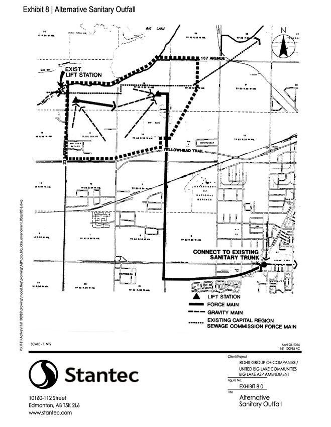
the amendment to the Kinglet Gardens Neighbourhood Structure Plan (NSP) but
            updating the land use and population statistics.
Bylaw 19527 Approved January 26, 2021 – to reconfigure lands for a stormwater management
            facility and low-density residential areas in Kinglet Gardens Neighbourhood.
Bylaw 19287 Approved March 16, 2021 - to designate portions of the Plan to public utility
            corridor.

Editor’s Note:
This is an office consolidation edition of the Big Lake Area Structure Plan, Bylaw 9878, as
approved by City Council on August 24, 1991.

This edition contains all amendments and additions to Bylaw 9878. For the sake of clarity, new
maps and a standardized format were utilized in this Plan. All names of City departments have
been standardized to reflect their present titles. Private owners’ names have been removed in
accordance with the Freedom of Information and Protection of Privacy Act. Furthermore, all
reasonable attempts were made to accurately reflect the original Bylaw. All text changes are
noted in the right margin and are italicized where applicable.

This office consolidation is intended for convenience only. In case of uncertainty, the reader is
advised to consult the original Bylaws, available at the office of the City Clerk.

City of Edmonton
Urban Form and Corporate Strategic Development*

Big Lake ASP Office Consolidation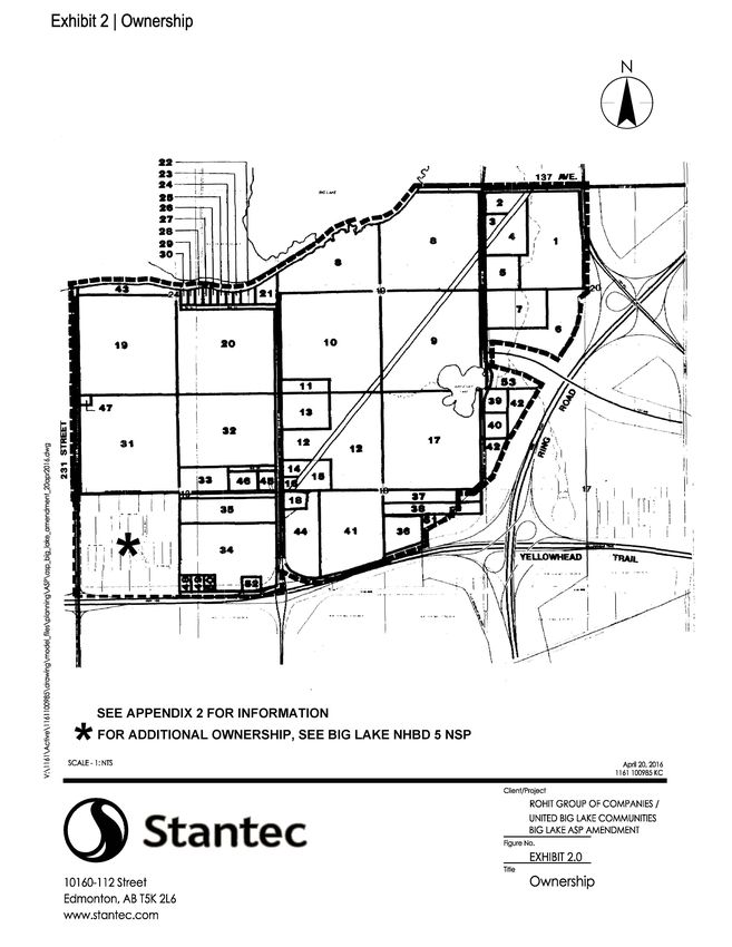
Bylaw 19287
            Approved March 16, 2021
Big Lake ASP Office Consolidation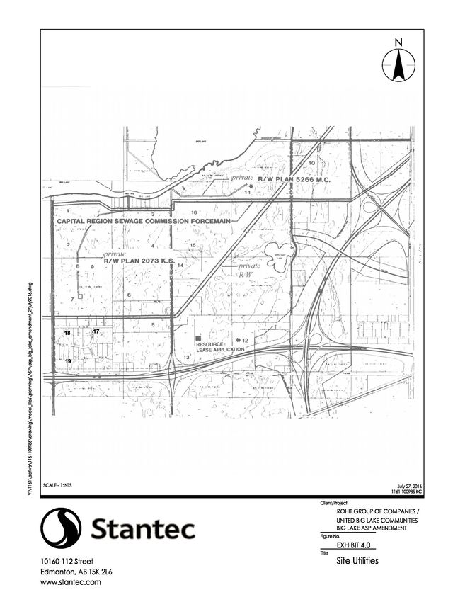
BIG LAKE
                                    AREA STRUCTURE PLAN

                                                              Prepared by

                                                IMC Consulting Group Inc.

                                                              On Behalf of

                                                       a private corporation
                                                        (Amended by Editor)

                                                             August, 1991

Big Lake ASP Office Consolidation
TABLE OF CONTENTS (Amended by Editor)

                                              Page

FOREWORD                                       1

1.0     INTRODUCTION AND BACKGROUND            3

       1.1   The Plan                          3
       1.2   Plan Area                         4
       1.3   Development Rationale             5
       1.4   Scope of Plan                     5
       1.5   Report Format                     6

2.0     CONTEXT                                7

       2.1 Regional Setting                    7
       2.2 Market Context                      7

3.0     DEVELOPMENT CONSIDERATIONS             9

       3.1 Introduction                        9
       3.2 Land Ownership                      9
       3.3 Geotechnical                        9

       3.5 Vegetation and Wildlife             12
       3.6 Existing Land Use                   16
       3.7 Adjacent Land Use                   19

4.0     DEVELOPMENT POLICIES AND OBJECTIVES    21

       4.1 General                             21
       4.2 Overall Objectives                  21
       4.3 Residential Objectives              22
       4.4 Commercial Objectives               22
       4.5 Schools                             22
       4.6 Open Space                          22
       4.7 Transportation                      23
       4.8 Utilities                           23
       4.9 Natural Environment                 23
       4.10 Existing Uses                      23

Big Lake ASP Office Consolidation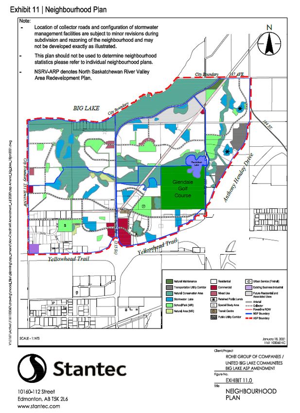
5.0     POLICY CONTEXT                                                24

        5.1 Edmonton Regional Plan                                    24
        5.2 Edmonton General Municipal Plan                           24
        5.3 North Saskatchewan River Valley Area Redevelopment Plan   25
        5.4 Big Lake Management Plan                                  26

6.0     LAND USE CONCEPT                                              28

        6.1 Development Concept                                       28
        6.2 Residential Land Use                                      30
        6.3 Future Residential & Associated Uses                      31
        6.4 Open Space/Park System                                    33
        6.5 Schools and Institutions                                  35
        6.6 Commercial                                                35
        6.7 Circulation System                                        36

7.0     ENGINEERING AND UTILITY SERVICES                              38

        7.1 General                                                   38
        7.2 Sanitary Drainage System                                  38
        7.3 Storm Drainage System                                     42
        7.4 Water Supply and Distribution                             51
        7.5 Utility Services                                          53

8.0     IMPLEMENTATION OF THE DEVELOPMENT                             54

        8.1 General                                                   54
        8.2 Staging                                                   54

LIST OF APPENDICES

                                                                      Page

APPENDIX 1 LAND USE STATISTICS                                        57
APPENDIX 2 LAND OWNERSHIP                                             60
APPENDIX 3 NOTIFICATION LETTER                                        64
APPENDIX 4 WELL LOCATION AND STATUS                                   67

Big Lake ASP Office Consolidation
LIST OF EXHIBITS
Page
1. LOCATION PLAN 8
2. OWNERSHIP 10
3. NATURAL SITE FEATURES 13
4. SITE UTILITIES 18
5. RIVER VALLEY PROTECTION AREA 27
6. LAND USE CONCEPT 29
7. SANITARY DRAINAGE SYSTEM 39
8. ALTERNATIVE SANITARY OUTFALL 40
9. STORM DRAINAGE SYSTEM 43
10. WATERMAIN SYSTEM 44
11. NEIGHBOURHOOD PLAN 55
Big Lake ASP Office ConsolidationFOREWORD
In order to encourage a continuation of development within the City of Edmonton
while at the same time ensuring that citizens of the City of Edmonton enjoy a high
standard of development with quality services for the lands covered by this Area
Structure Plan, the Council of the City of Edmonton has made the policy decision to
approve this Area Structure Plan recognizing the following limitations and
acknowledgements:
a) that final approval of residential servicing agreements remains subject to a
review of detailed plans of subdivision within the context of the approved
Infrastructure Performance Criteria necessitated by soil conditions as outlined
in detail in the body of the Plan and that the City, by approval of the Area
Structure Plan, does not warrant approval of any residential servicing
Amended by Editor
agreement or future rezoning;
b) that the City reserves the right to apply any additional Infrastructure
Performance Criteria specific to the lands covered by the Area Structure Plan,
in order to provide the quality services expected by the citizens of the City of
Edmonton;
c) that all development expenses and other costs, of every nature and kind, are
expended at the developer's sole risk and that any additional expenses incurred
by the developer as a result of any modifications resulting from the aforesaid
Infrastructure Performance Criteria are for the sole account of the developer;
and,
d) that notwithstanding Area Structure Plan approval, Neighbourhood Structure
Plan approval, rezoning approval, or subdivision approval, the developer will Amended by Editor
not apply for development permits or commence construction of buildings,
surface and underground improvements until the servicing agreements
encompassing the approved Infrastructure Performance Criteria have been
Big Lake ASP Office Consolidation 1executed and delivered, it being understood that this provision does not apply
to site preparation work already completed or in progress for which a
development permit or other approval has already been issued by the City.
Big Lake ASP Office Consolidation 21.0 INTRODUCTION AND BACKGROUND
1.1 THE PLAN
Bylaw 15986
The Big Lake Area Structure Plan describes the proposed development concept for an January 30, 2012
890 ha. (2,199 ac.) area of land located in the northwest sector of the City of
Edmonton. The plan has been prepared on behalf of two private landowners, the Amended by Editor
major owners of land within this area.
This document and accompanying plans have been prepared in accordance with
Section 64 of the Planning Act and with the City of Edmonton Terms of Reference
for residential area structure plans. Its general purpose as stated in the Act is to
prescribe proposed land uses, transportation and utility systems, population and
densities and the natural sequence of development for the area.
1.1.1. 2007 PLAN UPDATE
Bylaw 14802
In December, 2006, the Sustainable Development Department received an January 14, 2008
application for a new Neighbourhood Structure Plan for the first neighbourhood
within the Big Lake ASP. The application for the Big Lake Neighbourhood One NSP
was accompanied by an amendment to this Plan to redefine the general land use,
density and pattern of development and location of roadways for the lands located
within Neighbourhood One.
The Neighbourhood One NSP incorporates several more contemporary planning
principles and approaches that were not originally contemplated with this Plan.
Since its approval in 1991, there have been no amendments to this Bylaw. During
this time, planning policies and practices within the City of Edmonton have changed.
As a result, some of the information contained within this ASP pertaining to
Neighbourhood One is updated by the detailed guidelines and policies within the NSP
itself, and not specifically amended or described through the text of this Plan.
However, a summary of the changes affecting the Area Structure Plan, and therefore
affecting the Land Use Concept of this Plan incorporated through the adoption of an
NSP for Neighbourhood One, is listed below:
Big Lake ASP Office Consolidation 3• Changes to the arterial roadway network due to the Province’s acceptance of
the removal of the 128 Avenue flyover from Anthony Henday Drive, resulting
in adjustments to the boundaries of Neighbourhood One and adjacent
neighbourhood to the northeast;
• Elimination of a north-south collector roadway that intersects the portion of
the North Saskatchewan River Valley system in the central plan area; and
• Submission of an Area Master Plan amendment.
Changes relating specifically to Neighbourhood One within the Big Lake ASP are:
• Reconfiguration of the collector roadway network and recognition of the
Electrical Transmission Corridor right-of-way;
• As a result of the reconfigured neighbourhood boundary and collector
roadway network, redistribution of low and medium density residential uses,
commercial uses, parks and open space and stormwater management facilities
within the plan area;
• Removal of:
o One commercial site, leaving one commercial site relocated to the
northeast portion of the neighbourhood;
o A public elementary school site as a result of updated student
generation methods employed by Edmonton Public Schools;
• Addition of a mixed use site; and
• Simplification of land use designations as per current practice in new NSP’s
as either Low Density or Medium Density Residential.
1.2 PLAN AREA
The area for which the plan has been prepared is situated in the northwest sector of
the City of Edmonton. More specifically, the plan area includes parts of Sections 13
and 24 within Township 53, Range 26 and part of Sections 17, 18 and 19 and 20
within Township 53, Range 25, west of the 4th Meridian.
Big Lake ASP Office Consolidation 4The boundaries of the plan area are as follows:
North: The south shore line of Big Lake and the extension of 137 Avenue;
West: 231 Street which is the current west boundary of the City of
Edmonton;
South: The Northern boundary of the “Yellowhead Highway - Highway 16”. Amended by Editor
East: The outer edge of the Restricted Development Area (Transportation and
Utility Corridor) and the extension of 184 Street to the Outer Ring Road
(Anthony Henday Drive).
This delineation of the plan area creates a logical planning unit in terms of such
considerations as easily identifiable boundaries and development servicing
considerations.
1.3 DEVELOPMENT RATIONALE
The Edmonton City Council authorized the preparation of the Big Lake Area
Structure Plan 25 April 1989. The plan area is self contained as a result of the static
boundaries. These boundaries, which include the Big Lake, the Transportation and
Utility Corridor, the Yellowhead Highway, and the west boundary of the City of
Edmonton, are boundaries which are not apt to change over time, therefore restricting
expansion of the plan area in all directions. In addition to the above, the plan area
affords the future residents of the plan area and the City with unique and interesting
environmental areas and recreational opportunities.
The area can be served by existing and proposed economic, cultural, recreational,
educational and religious facilities available both in the immediate adjacent areas, as
well as within the plan boundary.
1.4 SCOPE OF PLAN
The Area Structure Plan as proposed provides for the orderly development of the
area, specifying land uses, residential density patterns, park and school requirements
and locations, the transportation network, and servicing and utility requirements.
Big Lake ASP Office Consolidation 5The design for the area is intended to establish a framework within which
development will take place and incorporates municipal requirements for the area, in
order that consistent and coordinated development may take place responsive to the
needs and requirements of the future residents.
The Area Structure Plan will provide a sound framework within which City Council
and relevant review agencies may properly and fully evaluate future Neighbourhood
Structure Plans and rezoning applications. Furthermore, the plan serves as a guide for
Amended by Editor
the Subdivision Authority to utilize when assessing detailed subdivisions.
It should be noted that the plan represents an optimum housing mix according to
present trends. As such, it must be realized that within the time span for
implementation of the plan, flexibility is required in order that changing demands can
be accommodated. These demands may be for marketing alternatives, new housing
forms and building types.
1.5 REPORT FORMAT
This document has been disaggregated into seven (7) major parts. The first provides a
brief introduction and background to the report. Sections 2 and 3 establish the basis
and framework such as the urban context, and development considerations. Section 4
of the document describes the development principles and objectives, Section 5 deals
with Policy Context, while Section 6 describes and outlines how the development
objectives have been translated into a land use and transportation concept Section 7 of
the report describes the engineering servicing systems that will provide water, storm,
sanitary, and transportation services into the area, while Section 8 outlines an
implementation strategy for the Big Lake Area.
A detailed statistical profile of the Big Lake Development concept is provided in
Appendix 1 of this Area Structure Plan. Appendix 2 details the land ownership within
the plan area. Appendix 3 is a copy of the notification letter and Appendix 4 details
well locations and their status.
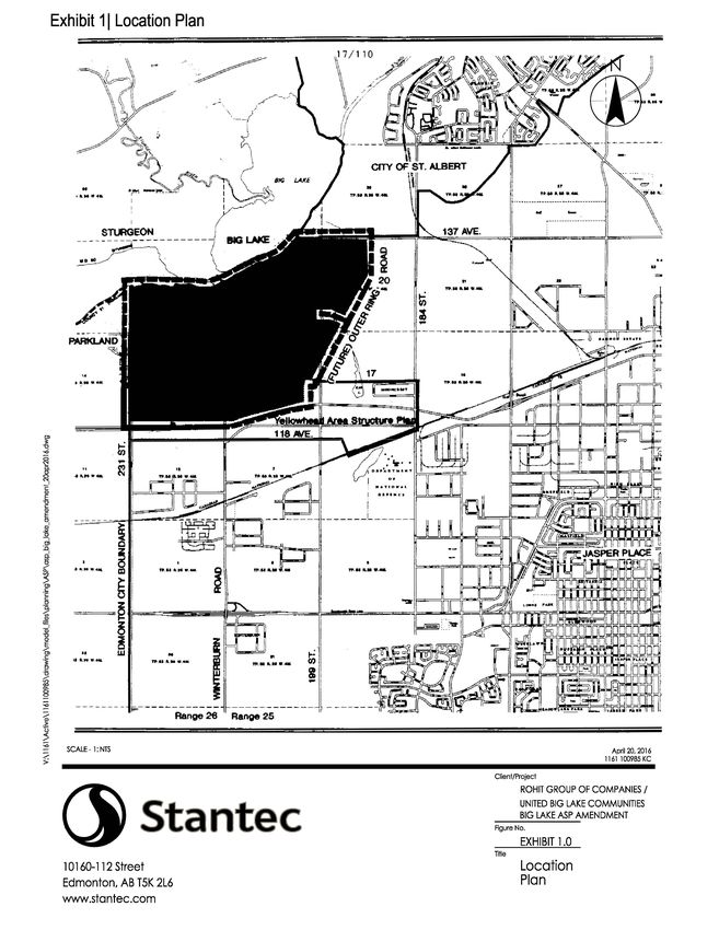
Big Lake ASP Office Consolidation 62.0 SITE CONTEXT 2.1 REGIONAL SETTING As illustrated by Exhibit 1, the Big Lake Area Structure Plan Area is located immediately north of Highway 16 (Yellowhead Trail) and west of the Restricted Amended by Editor Development Area. At present, the lands are accessible from Highway 16 (Yellowhead Trail) at 199, 215 (Winterburn Road) and 231 Street and from the extension of 137 Avenue from the east. In the future, the lands will be well served by the proposed regional scale transportation network, which will include the development of the Anthony Henday Drive and the extension of 184 Street, which Amended by Editor will provide convenient access to all parts of the City and the Provincial Highway network. 2.2 MARKET CONTEXT The plan proponents recognize that as the form of suburban neighbourhoods and personal preferences change, the requirements for servicing and neighbourhood forms will also change. Furthermore, they recognize the City's desire to maintain reasonable land prices through a competitive market. The plan proposes the use of predominantly low density residential development in conjunction with and adjacent to the environmentally sensitive areas. The recreational opportunities afforded by Big Lake are a major part of the market focus. This lower density type of development is a market which the owners believe will be of positive benefit to the City of Edmonton. Big Lake ASP Office Consolidation 7
Bylaw 17751
                                        December 13, 2016
Big Lake ASP Office Consolidation   8
3.0 DEVELOPMENT CONSIDERATIONS 3.1 INTRODUCTION In the preparation of the Area Structure Plan, it was necessary to examine existing site conditions and to inventory existing influences (natural and man-made) as these factors can affect the type and levels of development that can be achieved in the Big Lake area. These factors include topography, geotechnical information, vegetation, wildlife, existing land uses, resource extraction facilities, adjacent developments, and existing utilities. The implication of these factors is more fully described in the following sections. 3.2 LAND OWNERSHIP Of the 35 landowners within the plan area, all were sent notification by way of a notice delivered by regular mail (See Appendix 2). The circulation of the land use concept resulted in eight inquiries. Those inquiries were with respect to additional information regarding timeframe for development, location of school park sites, access to the shores of Big Lake, etc. As a result of the notification a number of additional copies of the plan were distributed. Those who inquired were generally in support of the plan, however, it should be noted that one objection to the plan was received with respect to the location of a school park site. 3.3 GEOTECHNICAL A comprehensive soil sampling and groundwater testing program has been prepared and submitted to the City for its review (AD. Williams Engineering Ltd. "Geotechnical and Groundwater Evaluation Big Lake Area Structure Plan"). The following is based on information contained within the aforementioned. Big Lake ASP Office Consolidation 9
Bylaw 17751
Big Lake ASP Office Consolidation   10
                                         December 13, 2016
The Canada Land Inventory (CLI) classifies the soil in the area as predominantly Class 3 and Class 4 capability, which suggests that moderate to severe limitations restrict the range of crops or require special conservation practices. Most of the site is covered by a thin organic topsoil layer, up to one meter in thickness, but generally in the range of 100 millimeters. Underlying the topsoil and/or peat is generally a glaciolacustrine deposit consisting predominantly of medium to high plastic clay material. The clay deposit is up to 83 meters in thickness but is generally in the range of three to five meters. A peat moss and organic soil deposit up to seven meters in thickness was encountered in the southeast corner of the study area. Furthermore, two meters of organic soils were encountered on the north shore of Horseshoe Lake. Based on air photo interpretation, a north-south trending depression extends from Horseshoe Lake to south of Highway 16 (Yellowhead Trail). This depression is likely in filled with thick Amended by Editor organic soils and peat as encountered in the aforementioned (A. D. Williams 1990). These organic soils for the most part are contained within the existing Glendale Golf Course. These areas, where necessary, will be addressed at the Neighbourhood Structure Plan stage by way of further study and specific design criteria so as to facilitate development. A groundwater monitoring program was undertaken to determine the local groundwater conditions and its influence on the proposed development. A total of 43 standpipe piezometers were installed in the field program. The piezometers were installed in the two main lithologic units; the clay and sand units. Nine of the 18 piezometers installed in the day unit have detected water. Seven of these have registered a water level within three meters of the ground surface. Seventeen of the 25 piezometers installed in the sand unit have detected water. Five of these have registered a water level within four meters of the ground surface. The deepest water level measured in sand piezometers was 15.4 meters below the ground surface. The program summarized a strong influence of the local topography, as well as the Big Lake ASP Office Consolidation 11
lithologic units, on the piezometers level. (A. D. Williams).

Normally, a groundwater elevation contour map is helpful in determining the
groundwater conditions, provided the topography is relatively even. Due to the wide
variance in relief of the study area, the groundwater conditions are elevated in terms
of the depth to water level below ground surface. Therefore, for preliminary

(Remainder of paragraph and Section 3.4 missing from original Bylaw)                     Amended by Editor

3.5     VEGETATION AND WILDLIFE
A comprehensive Environmental Evaluation of the Big Lake Area has been prepared
and submitted to the City for its review. (D. Penner 1990, Environmental Evaluation
of the Big Lake Area Structure Plan). The following information is based on the
aforementioned.

Most of the better drained lands within the study area have been cleared for
cultivation.

The remaining natural vegetation is generally associated with adverse topography
hydrologic and drainage characteristics which have generally precluded cultivation in
the past (see Exhibit 3).

Natural vegetation is characteristic of the Aspen Parkland Region with components of
the Boreal Mixed Wood Forest Region occuring in localized areas.

Trembling Aspen is the dominant tree species on the better drained uplands, while
Balsam popular frequent the moist areas.

Big Lake ASP Office Consolidation          12
Big Lake ASP Office Consolidation 13
Paper Birch and White Spruce occur sporadically in small stands.

Common understory species include Wild Rose, Saskatoon, Chokecherry, Snowberry,
Red Osier, Dogwood, Willow, Aster Bunchberry, Twin Flower, Yarrow and Grasses.

The steep north facing slope of Big Lake supports a diverse forest cover. Several
mature white spruce stands are notable vegetation features along this rugged terrain.
In addition, this slope contains a variety of understory plan species. The plan area
contains two larger tracts of natural forest cover. The first, a large wooded area west
of Horseshoe Lake, is a bog characterized by black spruce and Labrador tea and a
larch/sedge fen with some cattail and bulrush vegetation in the central, poorest
drained area (Penner 1990). These lands are for the most part within the NSRVARP.

The second natural area in the north half of Section 13 and portions of Section 24
covers about 28 ha. As determined by A. D. Williams (1990), this area contains an
upward hydraulic gradient in the area, suggesting a local discharge of water. The
groundwater discharge has influenced development of hybrid vegetation types,
notably a black spruce/larch-sedge-sphagnum bog near the discharge site and riparian
willow (balsam poplar-sedge communities along the drainage (Penner 1990). A
reconnaissance of the wooded area found a high degree of plant community and
wildlife habitat diversity within a localized area.

It would appear that the aforementioned areas are most probably maintained by poor
drainage and/or groundwater discharge. These conditions would appear to render
these lands unsuitable for subdivision development. The site conditions and
vegetation communities bear similarities to the Warner Bog, a special natural area
located 7 km west along Highway 16 (Yellowhead Trail). The Warner Bog supports a          Amended by Editor

variety of uncommon species such as orchids and carnivorous plants and a wide
variety of flowering plants. Similar species could be anticipated within the above-
noted areas and, as such, the perspective gained from the current evaluation is that
these bog habitats are significant natural areas worthy of preservation (Penner 1990).

Big Lake ASP Office Consolidation           14
Further study and evaluation is required at the Neighbourhood Structure Plan stage to
support an objective assessment of these habitats. These lands are within the
NSRVARP and, as such, the municipality has the option to attempt to acquire these
lands as Environmental Reserve pursuant to policy statements within the NSRVARP
and regulations within the Planning Act.

Another large area of natural vegetation (though less significant than the
aforementioned) is located within Section 19. This area supports a lush stand of large
ferns and an overstory of willow, red osier dogwood, high-bush cranberry,
honeysuckle, balsam poplar and aspen (Penner 1990). This vegetation community
would have high value for wildlife habitat, natural vegetation features and low
intensity recreational use.

As such, this area has been designated as Municipal Reserve so as to facilitate the
uses envisioned within the Big Lake Management Study (EMRPC 1989). The issue
of Municipal Reserve is dealt with in later sections of this plan.

These wooded areas and the associated shoreline of Big Lake support a diversity of
fauna. Approximately 43 mammal species (Smith 1979), 170 bird species and 7
species of amphibians and reptiles can be expected to occur as year round residents,
seasonal residents or migrants in the area. These areas provide potentially good
ungulate habitat as evidenced by the presence of white-tailed and mule deer within
the area. Other mammals in the area include coyote, red squirrel, snowshoe hare,
porcupine, ermine, striped skunk, pocket gopher, deer mouse, Gappees red-backed
vole and dusky shrew (Penner 1990). In addition, special habitat afforded by the tree
stands and bog areas within the NSRVARP may provide habitat for less common
species such as northern flying squirrel and water shrew.

The nature forest and variety of plant species provide habitat for, as previously
mentioned, 170 bird species including, but not limited to, ring-necked pheasants, gray
partridge, ruffed grouse, red-tailed hawk, marsh hawk, great horned owl and

Big Lake ASP Office Consolidation          15
goshawk, pileated woodpecker, downy woodpecker, blue jays, etc. (Penner 1990).

Most of the urban and recreational development (school park sites) proposed will
occur in the well drained uplands which have been previously cleared and cultivated,
therefore it will not displace significant numbers of wildlife.

As previously mentioned, the important wildlife habitat has been identified in the
land use concept as either Environmental or Municipal Reserve in accordance with
the requirements of the Planning Act.

These natural areas serve as a valuable amenity to the residents of the Big Lake Area
and, as such, further study will occur at the NSP stage to further redefine and
integrate these areas within the plan area. Attention will be given to the provision of
vegetated wildlife corridors in order to retain the larger wildlife species.

3.6     EXISTING LAND USE
The predominant land use within the plan area is agriculture, mostly grain and hay             Bylaw 17751
production. Several farmsteads and rural residences, including a country residential      December 13, 2016

subdivision—Big Lake Estates—exist through the area. The Glendale Golf and
Country Club exists within the plan area in the NE ¼ of Section 18. Should the
Glendale Golf and Country Club be redeveloped at a future date, reserves will be
provided to the satisfaction of the City of Edmonton in accordance with the Municipal
Government Act.

The plan area contains a private utility power line right-of-way-which traverses the      Amended by Editor
plan area from northeast to southwest (see Exhibit 4).

The private utility Right-of-Way Plan 5622 MC is an active natural gas pipeline (3")      Amended by Editor
that begins in the LSD 10 NE 1/4 Sec. 19– 53 – 25 – W4. The line travels westward
across the NW 1/4 Sec. 19–53–25–W4 exiting the plan area through Big Lake (NE
1/4 Sec. 24-53-25–W4). It is anticipated that the minimum lifespan of the gas

Big Lake ASP Office Consolidation           16
reserves is 10 years.

A second pipeline exists on the west aide of the plan area. Right-of-Way Plan 2073
K.S. is a crude oil pipeline which travels north through NW 1/4 Sec. 13-53-26-W4
and the SW 1/4 Sec. 24-53-26-W4 exiting the plan through Big Lake. The right-of-
way is held by a private corporation who has indicated that an application to           Amended by Editor
discontinue the operation of the line has been submitted to the Energy Resources
Conservation Board.

In addition, the Capital Region Sewage Commission force main (Plan 842–2193)
traverses the plan area from east and west and is located in the north portion of the
plan.

The Big Lake area has seen a number of wells drilled in the past. There are presently        Bylaw 17751
                                                                                        December 13, 2016
19 abandoned wells within the plan area. (See Appendix 4 and Exhibit 4). A private
corporation currently has an application for a resource lease in SW 18-53-25-W4.
The application is presently being reviewed by the Alberta Energy Regulator (see
Exhibit 4).

Big Lake ASP Office Consolidation        17
Bylaw 17751 Big Lake ASP Office Consolidation 18 December 13, 2016
The Alberta Energy Regulator held an inquiry in March and April of 1983 into
resource development and the possible conflicts between urban development in West
Edmonton. The Regulator found that reasonable co-existence was possible and they
recommended a set of land use planning guidelines. In September of 1985 Edmonton
City Council approved Policy Guidelines for the Integration of Resource Operations
and Urban Development. These guidelines were to ensure that urban uses and
resource operations can coexist without any adverse impacts.

The Big Lake Area Structure Plan will conform to the Alberta Energy Regulator
requirements and those guidelines approved by the City when integrating energy
resource facilities within the urban fabric. Extensive landscape screening will be
provided to the satisfaction of the City for the active well or any be developed at the
Neighbourhood Structure Plan stage. In addition, well sites will be configured in
accordance with required separation distances and to allow for their successful
integration into the surrounding land uses once the facility has been abandoned.

The existing land uses pose minor constraints to future development within the Big
Lake Plan area. However, in most cases existing land uses can be integrated into
residential subdivisions or recreational developments.

3.7     ADJACENT LAND USE
The adjacent land uses pose constraints to the future expansion and or enlargement of
the Big Lake Area Structure Plan. To the north the area is bordered by Big Lake and
the City of St. Albert. Both pose a significant constraint to expansion of the plan area.

The area south of the plan area is Highway 16 (Yellowhead Trail). The Yellowhead is              Bylaw 17751
                                                                                            December 13, 2016
a major transportation link within the Edmonton Metropolitan Area. The lineal piece
of land paralleling Highway 16 is presently within the boundaries of the Yellowhead
Corridor Area Structure Plan. These lands consist of a developed country residential
subdivision (low density) and vacant lands designated Industrial Business pursuant to
the Yellowhead Plan. Sustainable Development has requested that these lands, along

Big Lake ASP Office Consolidation          19
with the country residential subdivision – Big Lake Estates – be incorporated within the boundaries of the Big Lake Area Structure Plan. The City of Edmonton City Planning Department will amend the Yellowhead Corridor A.S.P. to designate these lands as predominantly single family residential. Adjacent to the east boundary of the plan is the Edmonton Transportation and Utility Amended by Editor Corridor. These lands are reserved for the future ring road (Anthony Henday Drive) and various utility and transmission installations. The corridor serves as a static boundary which constrains expansion of the plan area to the east. To the west of the plan area are lands contained within the Parkland County. These Amended by Editor lands are currently utilized for mixed use agriculture and country residential development. At the present time, the Parkland County is preparing an Area Structure Plan for approximately 8 sections of land immediately adjacent to the Big Lake Plan Area. These lands are being planned to accommodate low density country residential housing. This low density housing will compliment the low density residential envisioned in the Big Lake Area. Though the above pose constraints to expansion of the plan area, they do not constrain development within the plan area. Big Lake ASP Office Consolidation 20
4.0     DEVELOPMENT POLICIES AND OBJECTIVES

4.1     GENERAL
The Area Structure Plan, which is the intermediate link between the Edmonton                 Bylaw 17751
Municipal Development Plan and the Neighbourhood Structure Plan, provides the           December 13, 2016

overall policy framework for the development of the area. The recognition of the
potential role of the development area as an important segment of the urban fabric of
Edmonton leads to the formulation of a number of objectives which will guide the
development of the area. The following principles and objectives have guided the
preparation of the Development Plan for the Big Lake Area. These principles provide
the necessary framework and flexibility to accommodate changes in policies and/or
market conditions.

4.2     OVERALL OBJECTIVES
•       To provide a land use framework for the detailed planning of a high quality
        residential area and associated complementing land uses.
•       To conserve and optimize the use of natural environment through sensitive
        integration of the development with natural features.
•       To preserve all significant viewpoints and vistas and other significant views
        provided from the area.
•       To provide services to the standards of the City.
•       To provide planning flexibility and stimulate innovation in planning and
        design of residential areas.
•       To encourage energy efficiency in planning whenever possible.
•       To allow for economical phased development at the earliest practical date
        consistent with City policies.
•       To conform to the general intent and objectives of the Big Lake Management           Bylaw 17751
                                                                                        December 13, 2016
        Plan and Edmonton’s Municipal Development Plan.

Big Lake ASP Office Consolidation          21
4.3 RESIDENTIAL OBJECTIVES
• To create an attractive residential community.
• To conform to neighbourhood planning requirements utilizing quality urban
design principles.
• To promote the establishment of a community with a variety of housing Bylaw 17751
December 13, 2016
choices, providing alternatives for residents.
• To create sub-neighbourhood sectors which are flexible to change at
subsequent planning stages dependent upon area analysis and market
conditions at that time.
4.4 COMMERCIAL OBJECTIVES
• To satisfy the community and neighbourhood commercial needs of the Big Bylaw 17751
December 13, 2016
Lake Area.
4.5 SCHOOLS
• To establish locations for schools which meet the requirements of the Public
and Separate School Boards.
• To economize on land by joint use school/park sites.
4.6 OPEN SPACE
• To recognize the use of the power line corridor rights-of way for limited
recreational use.
• To meet the demands of future residents for active, passive and aesthetic
green space and recreational areas on both a neighbourhood and district scale.
• To fulfill the statutory requirements of the Planning Act by providing ten
(10%) of the area for open space and schools/or as money in lieu of municipal
reserve land.
• To preserve those lands determined to be environmentally sensitive in the Big
Lake Management Study and as defined in the Planning Act as Environmental
Reserve.
Big Lake ASP Office Consolidation 224.7 TRANSPORTATION
• To provide safe and convenient access for vehicles and pedestrians.
• To provide an efficient hierarchical circulation system for automobiles,
pedestrians, bicycles and public transit within the neighbourhoods which
connect with major arteries.
• To provide for the future regional transportation needs as identified by the
City of Edmonton and Province of Alberta.
4.8 UTILITIES
• To integrate power transmission corridors into the plan concept.
• To provide an economical servicing system and phasing sequence based on
extending City services and utilities.
• To utilize stormwater retention and detention facilities in the plan area as
amenity features whenever practical.
4.9 NATURAL ENVIRONMENT
• To maintain mature vegetation as an amenity feature where practical. Public
access to the natural environmental reserve areas will be highlighted for all
modes within the development area.
• Preservation of environmentally sensitive and significant areas.
4.10 EXISTING USES
• To allow for the continuation of existing uses, until the land is required to
accommodate urban development within each neighbourhood.
Big Lake ASP Office Consolidation 235.0 POLICY CONTEXT
A number of plans are currently in effect for the Big Lake Area. The plans are as
follows:
1. Edmonton Metropolitan Growth Plan Bylaw 18904
October 8, 2019
2. Edmonton Municipal Development Plan, The Way We Grow Bylaw 17751
December 13, 2016
3. North Saskatchewan River Valley Area Redevelopment Plan
4. Big Lake Management Plan
Bylaw 18904
5.1 EDMONTON METROPOLITAN GROWTH PLAN October 8, 2019
The plan area conforms to the Edmonton Metropolitan Growth Plan by managing Bylaw 17751
December 13, 2016
sustainable growth in a manner that protects the region’s environment and resources,
minimizes the regional development footprint, strengthens communities, increases
transportation choices and supports economic development.
5.2 EDMONTON MUNICIPAL DEVELOPMENT PLAN, THE WAY WE Bylaw 17751
December 13, 2016
GROW
Although the Big Lake ASP was approved under the Edmonton General Municipal
Plan, the Big Lake ASP conforms to the City’s Municipal Development Plan. In May
2010, City Council approved a new Municipal Development Plan titled The Way We
Grow. The Way We Grow is a comprehensive plan which provides direction of
development and implementation of more specific and detailed plans the industry and
private landowners as well as the City.
The land within the Big Lake ASP is designated in The Way We Grow as Developing,
Planned and Future Neighbourhoods. The Big Lake ASP complies with the policies of
The Way We Grow by:
• protecting the North Saskatchewan River Valley and Ravine System;
• providing a balance of land uses including commercial, institutional, natural
and recreational; providing a variety of housing choices with higher densities
in proximity to the transit centre and employment areas;
Big Lake ASP Office Consolidation 24• represents contiguous growth in northwest Edmonton with areas to the north
and east developed and currently under development; and
• provides a well-integrated pedestrian network of multi-use trails, walkways
and sidewalks to provide for a variety of modes of active transportation
5.3 NORTH SASKATCHEWAN RIVER VALLEY AREA
REDEVELOPMENT PLAN
The purpose of the NSRVARP is to "protect the North Saskatchewan River Valley
and Ravine System as part of Edmonton's valuable open space heritage and to
establish the principles for future implementation plans and programs for parks
development". By enunciating policies and a plan of action, the NSRVARP forms
part of a comprehensive River Valley and Ravine Management programme.
Portions of the Big Lake Area Structure Plan are contained within the NSRVARP. It
is the intent of the Big Lake ASP to comply with the purpose of the Plan by
protecting those River Valley and Ravine lands. Section 3.2.8 of the NSRVARP
states, "It is the policy of this plan that the City may acquire through subdivision, all
lands lying below the geomorphic limit of the River Valley and Ravine systems as
Environmental Reserve in accordance with the provisions of the Planning Act."
Those environmentally sensitive lands, as determined in conjunction with the Asset
Management and Public Works Department, the Sustainable Development Amended by Editor
Department, and an environmental consultant, will be dedicated as Environmental
Reserve, pursuant to the Planning Act, at the time of subdivision.
5.4 BIG LAKE MANAGEMENT PLAN
The subject Area Structure Plan has complied with the Big Lake management plan.
Land within the plan area are for the most part allocated as Agricultural/Long Term
Residential Development Potential and Natural Maintenance. As well, small pockets
of Natural Conservation, Existing Commercial Recreation and Agricultural/Long
Term Recreational Development Potential are found within the plan area. The
development proposed has been developed in accordance with the purpose and
provisions of the various land use classifications within the Big Lake Management
Big Lake ASP Office Consolidation 25Plan. More specifically, those lands indicated as natural conservation will be acquired as Environmental Reserve at the time of subdivision. Land designated Natural Maintenance will for the most part be designated as Municipal Reserve where possible and utilized for recreational purposes having due regard to soil limitations and/or sensitive vegetation and wildlife. The issue of Environmental and Municipal Reserve will be in accordance with the Planning Act and City policy. This issue is dealt with in greater detail later in the report. The Big Lake Management Plan envisaged a lower density than normally found in typical subdivisions within the City. Big Lake ASP Office Consolidation 26
AREA WITH LESS THAN 3 METRES OF CLAY COVER

                                    GROUNDWATER TABLE WITHIN 4 METRES OF GROUND
                                    SURFACE (BASED ON 1990-02-08 READINGS)
                                    RIVER VALLEY PROTECTION AREA

Big Lake ASP Office Consolidation
27
6.0 LAND USE CONCEPT
6.1 DEVELOPMENT CONCEPT
The development concept prepared for the Big Lake Area has evolved in response to
several factors including:
• natural site features
• physical and functional relationships to Big Lake.
• access considerations
• servicing considerations
• the Big Lake Management Plan
• Edmonton’s Municipal Development Plan, The Way We Grow Bylaw 17751
December 13, 2016
• North Saskatchewan River Valley Area Redevelopment Plan
The intent of the development concept is to integrate these factors in order to guide
future urban development in a rational manner.
Overall, the concept calls for the development of five residential neighbourhoods. Bylaw 17751
December 13, 2016
The following sections identify in greater detail the major land uses within the
development concept and their relationships to each other. The infrastructure systems
which support the development concept are detailed in the following section (see
Exhibit 6).
Big Lake ASP Office Consolidation 28Bylaw 19287
Approved March 16, 2021
Big Lake ASP Office Consolidation 296.2 RESIDENTIAL LAND USE
The majority of land within the Big Lake Area is designated for residential purposes. Bylaw 17751
The plan provides for a range of dwelling types and densities permitting a choice of December 13, 2016
accommodation. Residential densities within the Big Lake Area can be determined
from Table 2 (Land Use Statistics) and should be calculated from the adjusted gross
developable area which deletes the 53.93 ha Glendale Golf Course.
The emphasis is being placed on low density residential due to the suburban type Bylaw 17751
December 13, 2016
market envisioned for the area as a result of the distance from the city centre. It is
anticipated that the low density residential will be developed with densities of
approximately 22 dwelling per gross hectare. The area of low density residential
development proposed, not including lands designated as Future Residential and
Associated Uses, is provided in Table 2 (Land Use Statistics).
In addition, the plan calls for medium density residential development. Medium Bylaw 17751
December 13, 2016
density residential development consists of row housing, stacked row housing and low
rise apartments accommodated by the RF5, RF6 and RA7 zones. Medium density
residential housing will be provided at varying densities ranging from 42-125
dwelling units per hectare. Medium density residential housing has been provided
throughout the plan area having regard to surrounding land uses and the
transportation network. The area of medium density residential development
proposed, not including lands designated as Future Residential and Associated Uses,
is provided in Table 2 (Land Use Statistics).
An area approximately 21.55 ha (53.25 ac) has been designated as a Special Study
Area. A portion of this land is presently owned by a private corporation and utilized Amended by Editor
for parking. A portion of the Special Study Area (3.22 ha) is ravine lands covered by
Bylaw 17673
the North Saskatchewan River Valley Area Redevelopment Plan. These lands may February 22, 2017
consist of recreation and/or specialized residential uses. The parameters and details of
this area will be further defined in the context of an Area Structure Plan Amendment
in the future.
Provision of social housing within the plan area will be in response to demand. The
amount and location of public housing sites will be determined in conjunction with
Amended by Editor
Big Lake ASP Office Consolidation 30the Housing and Economic Stability section of the Sustainable Development
Department at the Neighbourhood Structure Plan stage.
The plan recognizes the need to buffer residential lands from the Yellowhead Trail. Bylaw 17751
December 13, 2016
The specification and determination of such buffering will be determined at the
Neighbourhood Structure Plan stage. In addition the plan recognizes that buffering
may be required where development is directly adjacent to Big Lake Estates Country
Residential Subdivision. Any buffering provided will consist of an open landscaped
space and/or a grassed berm. The details of the buffering will be further defined at
the Neighbourhood Structure Plan stage. Similar buffering is envisioned along the
west side of the lands presently occupied by the Glendale Golf and Country Club.
It is anticipated that figures regarding residential development will vary over the
development period in response to changing factors including, but not limited to,
market preference, interest rates, and household sizes.
In keeping with the low density intent of the plan, high density apartment housing has
not been proposed within the plan area.
Bylaw 15986
6.3 FUTURE RESIDENTIAL AND ASSOCIATED USES Jan. 30, 2012
The Future Residential and Associated Uses designation is intended to be and interim
and generalized land use designation. It applies to two areas within the ASP. The
larger of the two areas is located within the north portion of the Trumpeter
neighbourhood. The smaller is located within the northwest corner of the Starling
neighbourhood.
The designation is intended to be interim and generalized in recognition that the
affected landowner is not yet prepared to undertake detailed planning for the affected
lands. However, it does provide the landowner or future developer an increased level
of certainty that the subject lands will be considered by the City of Edmonton for
residential expansion. Prior to any rezoning or subdivision of the lands within this
area, an NSP amendment will be required to layout the exact type of residential and
associated uses to be developed and further detailed studies (i.e., traffic impact
assessment, drainage reports, etc) will also be required.
Big Lake ASP Office Consolidation 31The residential density of these areas should strive to meet the same density planned Bylaw 18904 in the balance of their NSPs or higher in order to meet the density targets assigned by October 8, 2019 the Edmonton Metropolitan Region Growth Plan to this portion of Edmonton. The associated uses component of this designation acknowledges that the future development of low and medium density residential uses will require the development of supporting related uses. Associated uses included circulation (public road, walkways, lanes if necessary, etc), municipal reserve (parks), and public utility lots (stormwater management facilities, utility right-of-ways, lift stations if necessary, etc.). The Future Residential and Associated Uses designation does not include an opportunity develop any type of commercial uses to support the future residential development, the respective neighbourhoods, or to the greater Big Lake area. Such a development proposal would necessitate and ASP amendment with sufficient rationale to support the re-designation of land for commercial uses in this area. Other non-residential uses, such as those prescribed in the Urban Services Zone of the Edmonton Zoning Bylaw (libraries, churches, community centres, etc) would also necessitate an ASP amendment. Some of the lands designated Future Residential and Associated Uses within Trumpeter are encumbered by pipeline right-of-ways and abandoned wells. The future Trumpeter NSP amendment to undertake more detailed planning within the Future Residential and Associated Uses area shall investigate these encumbrances and appropriately incorporate them and their setbacks, if applicable, into the design of the residential area. As the future Residential and Associated Uses areas are adjacent to a regional sewer line and power corridor, the more detailed planning at the future NSP amendment stages for both neighbourhoods shall require consultation with the Alberta Capital Region Wastewater Commission (ACRWC) and AltaLink on any applicable setback requirements or any additional right-of-way requirements. This will ensure these facilities are protected from incompatible development and that additional land for regional infrastructure is identified, if necessary. Big Lake ASP Office Consolidation 32
6.4     OPEN SPACE/PARK SYSTEM
The components of the open space/park system includes areas of land within the
NSRVARP, combined school park sites, neighbourhood parks, pedestrian walkways
and an existing golf course.

The Municipal Reserve lands proposed within the plan area consist of several sites,
                                                                                                 Bylaw 17751
some of which are joint school park sites. A portion designated natural maintenance         December 13, 2016

area is included in the municipal reserve.

(Paragraph deleted by Bylaw 15546, September 13, 2010)                                           Bylaw 14802
                                                                                             January 14, 2008

Further to the above, a large area of land 63.81 ha (157.67 ac) located in the northeast
portion of the plan area adjacent to the major arterial road has been identified as being
environmentally sensitive. The City will attempt to acquire these lands as Municipal
Reserve. This area reflects the Big Lake Management Plan which designates these                 Bylaw 15986
lands as a combination of Natural Conservation Area and Natural Maintenance. This               Jan. 30, 2012

area reflects the Big Lake Management Plan which designates these lands as a
combination of Natural Conservation Area and Natural Maintenance. These lands
will be utilized as areas of active and passive recreation providing a large regional
park within close proximity to Big Lake. The lands represent areas of severe
development limitations potentially due to soil limitations and/or sensitive vegetation
and wildlife. It must be ensured that future use and development of these areas is in
harmony with its identified sensitivity relating to soils, vegetation and/or wildlife.
The importance of these lands has been explained in previous sections.

The total Municipal Reserve lands proposed are outlined in Table 2 (Land Use                     Bylaw 17751
                                                                                            December 13, 2016
Statistics). Should the Provincial Government or the City of Edmonton be unable to
purchase the entire portion of Municipal Reserve lands designated as Natural
Maintenance pursuant to the Big Lake Management Plan, these lands may be
developed as low density residential.

Another integral component of the open space system is those lands delineated as                 Bylaw 17751
                                                                                            December 13, 2016
Natural Conservation Area, which includes Environmental Reserve (ER). The amount

Big Lake ASP Office Consolidation            33
of Natural Conservation Area designated within the plan is outlined in Table 2 (Land
Use Statistics). All of those lands included with the statistics of the five
neighbourhoods will be dedicated as ER. For those lands within the balance of the
ASP, only the portion of those lands below the top-of-bank can be dedicated as ER.
The Natural Conservation Area lands consist of sensitive areas contained within the
boundary of the NSRVARP and designated areas of natural conservation under the
Big Lake Management Plan. The sensitivity of and reason for preservation of these
lands has been previously indicated in Section 3.5. These lands will be surveyed in
detail in conjunction with Sustainable Development and an independent
environmental consultant at the Neighbourhood Structure Plan stage. Those lands
deemed Environmental Reserve will be acquired by the municipality upon subdivision
in accordance with the Municipal Government Act. Those lands not deemed ER may
be acquired by the City through other means, of which some could be dedicated as
Municipal Reserve.
As well, it should be mentioned that the Big Lake Plan area contains the Glendale
Golf and Country Club. This facility consists of 18 holes of golf, a clubhouse and
associated maintenance buildings.
Pedestrian walkways also form part of the open space system. However, as they serve
an important function with respect to circulation, their discussions is contained within
Section 6.6.
Additional parkland may be identified at the Neighbourhood Structure Plan stage.
The City has the option of redefining Municipal Reserve requirements (other than
those required for school/park purposes) at the NSP stage.
6.5 SCHOOLS AND INSTITUTIONS
School sites are a dominant factor in establishing the configuration of residential
neighbourhoods.
(Paragraph deleted by Bylaw 15546, September 13, 2010) Bylaw 14802
January 14, 2008
The size of the sites has been determined in conjunction with the Public and Catholic Bylaw 17751
December 13, 2016
Big Lake ASP Office Consolidation 34School Boards and the Sustainable Development Department - Parks Planning
Branch.
The exact location of the school sites and frontage for school sites will be addressed Bylaw 17751
December 13, 2016
in detail at the Neighbourhood Plan stage and will be in accordance with the School
Boards and Sustainable Development, Parks Planning Branch requirements. No
utilities or pipeline corridors of any kind will be permitted to bisect school or park
lands and all sites shown will be serviced by the Developer at no cost to the City. It
should be noted that the Edmonton Public School Board have requested that
educational facilities be provided on the basis of a two tier system (Elementary K-8,
HighSchool 9-12) as opposed to a three tier system (Elementary K-6, Junior High 7-
9 and High School 10-12).
Other institutional uses will depend to a large degree on civic and provincial
programs and policies at the time of development. Most uses, such as a police station,
fire hall, library, social or health service centers, are to be located in Edmonton
Communities to the south and east. Potential church sites are not specifically
identified. The actual location of church sites will be identified at the Neighbourhood
Structure Plan stage; depending on social and market requirements. Should it be
determined that additional lands are required for other institutional uses such as
police, firehall, and library sites, they will be identified at the NSP stage.
6.6 COMMERCIAL
Several commercial sites and commercial/residential mixed use sites are proposed to Bylaw 17751
December 13, 2016
serve the community level and neighbourhood needs of the plan area. There are
neighbourhood sites, neighbourhood mixed use sites (commercial component only),
and the main commercial area at Yellowhead Trail and 215 Street that will serve the
shopping and local retail needs of the residents of Big Lake. The smaller sites will
provide convenience commercial and neighbourhood service uses for the residents.
No commercial uses may be developed within those lands designated Future
Residential and Associated Uses without amendment to the ASP and the future
Trumpeter NSP.
6.7 CIRCULATION SYSTEM
Big Lake ASP Office Consolidation 35You can also read