BIM Model Landscape_Open Spaces: An Approach for Landscape and Environmental Planning in Infrastructure Projects - gis.Point
←
→
Page content transcription
If your browser does not render page correctly, please read the page content below
344                                                                                              Full Paper

BIM Model Landscape_Open Spaces: An Approach
for Landscape and Environmental Planning in
Infrastructure Projects
Ilona Brückner1, Matthias Remy2
1University   of Applied Sciences, Osnabrück/Germany · i.brueckner@hs-osnabrueck.de
2University   of Applied Sciences, Osnabrück/Germany

Abstract: Using the example of the landscape planning aspects of the BIM Autobahn Pilot Project
A10/A24, the increased value of engineering projects using BIM to integrate landscape and environ-
mental planning is demonstrated. The basis is the development of the Landscape_Open Space model.
This leads to improved communication for all participants especially in regards to planning meetings
and appointments. On this basis, the concerns of landscape and environmental conservation can be
better considered during the building phase.
Keywords: Building Information Modeling, landscape design, BIM workflow, BIM elements

1      Introduction
The German federal government aims to use Building Information Modeling (BIM) for all
future public infrastructure projects costing over 5 million euros. Project participants should
supply obligatory performance results in digital form, and be able to participate with other
project partners digitally. The long-term goal is to use BIM in construction projects over the
entire process: from planning, building, and operation, all the way to dismantling (BMVI
2015). Until now landscape and environmental planning have often played only a marginal
role. However, they are of increasing importance as can be seen in such projects as the second
main S-Bahn line in Munich (DB Netz AG) (OTTO 2019), the autobahn intersection at the
Funkturm in Berlin (DEGES) (BERGER 2020), and others.
The advantages of the cooperative planning method of BIM are seen above all in the possi-
bility of optimizing the collaborative effort of the different trades by increasing the quality,
lowering the costs, and keeping to the projected period of construction. In linked planning
processes, traffic and landscape planners work together for the best possible solution for the
realization and operation of traffic routes. An optimized flow of information between actors
of the various areas of expertise is a necessary requirement for having high quality, interdis-
ciplinary planning results. The integration of landscape and environmental planning in the
BIM processes of infrastructure building seems therefore advisable.
Until now the use of BIM in landscape architecture has been concentrated in the area of object
planning, and the first workflows have been developed (BRÜCKNER et al. 2018). In contrast,
BIM has rarely been used in landscape and environmental planning. This issue was addressed
in the research semester of the Master of Landscape Architecture program at the University
of Osnabruck. The goal was to develop a method of integrating landscape conservation into
the BIM process of road construction (REMY 2020). This was carried out using the BIM pilot
project “PPP-A10/A24 (Public Privat Partnership) in cooperation with the working group
ARGE A10/A24 Havelland Autobahn. ARGE is a part of the contractors’ consortium and is
responsible for the area of planning and construction.

Journal of Digital Landscape Architecture, 6-2021, pp. 344-352. © Wichmann Verlag, VDE VERLAG GMBH ·
Berlin · Offenbach. ISBN 978-3-87907-705-2, ISSN 2367-4253, e-ISSN 2511-624X, doi:10.14627/537705031.
This article is an open access article distributed under the terms and conditions of the Creative Commons
Attribution license (http://creativecommons.org/licenses/by-nd/4.0/).
I. Brückner, M. Remy: BIM Model Landscape_Open Spaces                                                                                   345

There is an especially close interlinking with the BIM processes in infrastructure construction
with the environmental impact assessment (LBP) as well as the landscape management de-
tailed design phase (LAP). The basis for the BIM method is the sectoral planning, which is
brought together in a 3D coordination model and tested for consistency. This follows on the
basis of the international, non-proprietary interface Industry Foundation Classes (IFC) of
digital descriptions of the construction models which are based on 3D models of components,
volumes, etc. The IFC interface assures the open BIM process. This means that all planners
can work using their own specific software. In the ideal case, the current state of planning is
available for all parties involved, as rule in the cloud-based Common Data Environment
CDE. The digital building models can be used as an information databank and as reliable
sources for decision making during the entire life cycle of the structure.
The coordination model for the BIM Pilot Project A10/A24 at this time makes use of a 3D
model for the ground surface, subsoil level, road segment, petrol and rest areas, as well as
civil engineer constructions (see Fig. 1). Landscape plans are provided by the responsible
landscape and environmental planners as 2D CAD plans, and therefore cannot be integrated
in the overall coordination model. Weaknesses in the communication of landscape and envi-
ronmental planners with other project participants as a result of differing planning methods
seem foreseeable.

                                                                          Model

            Ground surface            Subsoil level     Road segment         Petrol and rest        Civil engineer         Landscape
                                                                                  area              construction
           BIM coordinator          BIM coordinator    BIM coordinator       BIM coordinator      BIM coordinator        BIM coordinator
Planner
              BIM builder             BIM builder        BIM builder           BIM builder          BIM builder            BIM builder

             Existing ground                                Route                                   Existing bridge
Submodel         surface
                                        Soil layers                               Traffic areas                            Submodel 1
                                                         construction                                construction
              New ground              Highest ground                                                    Bridge
                                                            Sector                   Sector                                Submodel 2
                 surface                water level                                                  construction
                                                           Drainage                Drainage         Reinforcement
           Graphic: ARGE Havellandautobahn A10/A24
                                                        Design elements       Design elements      Noise barrier wall
                                                         Support roads                            Road sign cantilever
                                                           and paths

Fig. 1: Extension of the existing model through the Landscape_Open Space Model (ARGE
        Havellandautobahn A10/A24)

2         Standardizing BIM
For the successful implementation of projects using BIM, a strong structuring and standard-
ization of the processes is necessary, especially in regards to data exchange (who delivers
what, when, to whom and to which degree….). At present, necessary standards are still being
developed. This holds true for the extension of the data exchange format IFC for infrastruc-
ture building objects (IFC Road, IFC Rail, etc.) which are also, to some degree, relevant for
landscape architecture. At the moment, the most current IFC version (4.3 RC2), in the “can-
didate stage”, has few elements to describe bridges and infrastructure elements on the basis
of lines (IfcBridge, IfcAlignment, see BUILDINGSMART 2021). First, with IFC 5.0 will there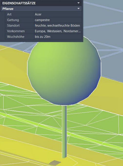
346                                            Journal of Digital Landscape Architecture · 6-2021

be comprehensive consideration: international working groups from buildingSMART will be
working from here on. When compared to structural engineering, the BIM method is less
developed in regards to data standards and software tools, on the national as well as on the
international levels. (Overview in KÖNIG et al. 2016, BORMANN & HEUNECKE 2020). A first
attempt in Norway to standardize objects in land design has not yet been integrated in inter-
national standardization processes (WIK et al 2018).
For the use of BIM in Germany, a three-step plan (BMVI 2015) was formulated by the Fed-
eral Ministry for Transport and Digital Infrastructure already in 2015. The goal was the im-
plementation of BIM as standard on a broader basis by the year 2020. To reach this goal, a
series of BIM pilot projects were carried out and supported. To support project sponsors, as
well as all other project participants putting BIM to practice, the results and findings were
summarized in ten guides which are readily available, and which also offer landscape archi-
tects a first orientation for the structuring of BIM projects, BIM applications, the content and
development of information requests by principals (AIA), and BIM as well as winding up
plans (BAP) (BIM4INFRA2020 2019). The goals of the phased plan have not yet been able
to be fully realized. The work is to be further developed for both building construction and
infrastructure in the newly established Center for Digitalization in Construction, “BIM
Deutschland” (BIM DEUTSCHLAND 2021)
The lack of standards for required information on the national level continues to lead to the
parallel development of isolated solutions.
A contribution to the (pre)standardization on the national level is the recently published cat-
alog “BIM Classes of Traffic Routes” put together by the working group BIM Traffic Routes
of buildingSMART Germany. This was supplemented by the team of specialists BIM in land-
scape architecture who supplied classifications of landscape and open spaces so that in the
future, environmental requirements can also be represented in BIM models. There continues
to be further development of features of this first version (BUILDINGSMART-FACHGRUPPE
BIM-VERKEHRSWEGE 2020).

3     Integration of Landscape and Environmental Planning in the
      BIM Process
3.1   BIM Autobahn Pilot Project A10/A24
The autobahn project PPP-A10/A24 used a 5.5 kilometer road section to tender and be
granted as the BIM pilot project. A diverse number of BIM case applications from BIM co-
ordination on basis of the model were tried out, first as prototypes, and then finally put into
practice. These ranged from visualizations to the use of BIM models in operations and in
maintenance (TSCHICKARDT & KRAUSE 2019). The Deutsche Einheit Fernstraßenplanungs-
und -bau GmbH (DEGES), which realizes largescale infrastructure projects in Germany, is
responsible for the project. The planning and implementation of the project were carried out
by ARGE A10/A24 Havellandautobahn GmbH.
The segment of autobahn used in the project is 64.2 kilometers long and belongs to one of
the most heavily driven sections in the Berlin area. Within the next 5 years, it is to be up-
graded and repaired while still being used. The contractor of the PPP project is to plan, build,
maintain and partially finance the different construction measures over a period of 30 years.
I. Brückner, M. Remy: BIM Model Landscape_Open Spaces 347
ARGE A10/A24 Havellandautobahn GmbH has developed an overview structure for all
models used in cooperation by the project participants in the BIM Coordination Model. The
models can therefore be accordingly subdivided into further component models, structural
element groups and model elements. The information of a model can be passed along hierar-
chically. The chosen project structure offers the project participants user friendly navigation
in the coordination model and assures access to required information.
3.2 BIM Model Landscape_Open Space
The Landscape_Open Space Model is furthermore being developed to integrate landscape
and environmental planning issues into the BIM Model of the PPP-A10/A24 project. (Fig. 1)
The landscape conservation implementation plan, in accordance with the predefined struc-
ture, is then organized in the Landscape_Open Space Model. The technical terminology that
is used comes for the most part from the pre-standardized work “BIM Transportation Route
Classifications” (BUILDINGSMART-FACHGRUPPE BIM-VERKEHRSWEGE 2020). Illustration
2. Shows the structure of the Landscape_Open Space Model. It is divided into two parts. This
division is based on the State of Hessen’s concept for landscape conservation implementation
planning (LAP). The goal of this concept is to make the often complex landscape conserva-
tion plans more accessible in construction preparation.
Model structure
Landscape
Open space
Environmental concerns Impact mitigation &
throughout the entire construction composition measures
Structural element
Topsoil
Landscape planning
Protected area Surface cultivation
Protected object Vegetation
Storage, work and
temporary planting sites Plants
Cultural assets, material
property Plant rows
Habitat Area of vegetation
Boundries Design elements
Landscape management
Vegetation Raptor perch
Plants Browsing protection fence
Plant rows Pest control
Area of vegetation
Maintenance
Environmental Project development
protection maintenance
Protective devices Establishment
maintenance
Crossing aids
Legend
Earthworks Model
Cut material Submodel
Intermediate storage Construction unit
Infilling Model elements
Fig. 2: Structure of the Landscape_Open Space Model
Using the submodel, “Umweltbelange während der gesamten Bauphase” (UwbB), i. e. Envi-
ronmental Concerns throughout the Entire Construction, particularly landscape and environ-348 Journal of Digital Landscape Architecture · 6-2021 mental mitigation measures are modeled throughout the entire building phase. Model ele- ments include protected areas; protected objects; storage, work and temporary planting sites; protected plants, or trees to be felled. This submodel is available to all project participants and is meant to serve the environmental monitoring of construction. The contents of the submodel “Ausgleichs- und gestaltungsmaßnahmen” (AuG), i. e. Impact Mitigation and Composition Measures are primarily oriented to carrying out environmental measures. Examples are compensation planting, as well as protective objects such as raptor perches or browsing protection fences. Development, maintenance and finalization measures can also be linked to the submodel. In general, it makes sense to divide the mitigation, compensation and design measures into two submodels in that for example the measures of the UwbB submodel are carried out much earlier than submodel AuG. It can also help make understanding details easier. The UwbB submodel was modeled on a 2 km segment of the entire 5.5 kilometer contract section, and was integrated into the BIM coordination model of the project. All required in- formation for the project was taken from the existing LBP and LAP. Because there were no pre-defined landscape classifications, these had to be generated generically and semantically described by means of user-specific features. 3.3 3D Models in CAD-BIM Software Autodesk Civil 3D, often used as the modeling software in BIM infrastructure projects, was chosen for use in this case. It is complemented by an engineering application module. The current dominance of CAD solutions in BIM infrastructure projects can be attributed to the cooperation of Autodesk with ESRI in the development of interfaces for optimizing data ex- change between BIM CAD and GIS in BIM processes. Road planners in the A10/A24 Project therefore used Autodesk Civil 3D to enable a seamless data exchange. Autodesk Civil 3D having the required IFC interfaces builds upon the functions pallet of Autodesk AutoCAD offering 3D tools for engineering and infrastructure planning as well as site modeling and processing. The last was essential in creating the submodel UwbB because the digital site model which encloses the route using BIM coordination model, needed to be allocated to different zoning areas. Accordingly, areas of the DTM near the construction site were declared protected areas, or storage and work sites. For this, specific areas were cut out of the DTM and using the same coordinates exported as new DTM: The exported DTM could then be seamlessly connected in new data. Within the Civil 3D Autodesk software, such generated areas were assigned the function “define characteristics” of different zonings and features. Additionally, for defined work sites, the DTM was converted into solids so that soil that was to be removed could be automatically calculated already in the BIM model. Point objects in the UwbB submodel such as single plants, or linear objects such as fences or topsoil pits, were extracted as 3D solids and linked to specific features. The landscape classification Plants is used as an exam- ple in Figure 3. Because a realistic visualization is not required here, an abstract 3D tree model is sufficient. This required a lot of individual work. Libraries having landscape objects and tools available that support modeling are necessary to enable efficient work in the future.
I. Brückner, M. Remy: BIM Model Landscape_Open Spaces 349
Fig. 3:
Landscape Classification – Plants
3.4 BIM Coordination Model in the BIM Management Software
To bring the individual models together in the coordination model a BIM Management soft-
ware is required. Desite BIM md pro was used and the data exchange was based on IFC.
The submodel UwbB was subsequently transferred into IFC and could successfully be im-
ported into the BIM coordination model for the PPP A10/A24 project. This means that all
geometrics were available in data already entered.
With help of the BIM management software, a hierarchical data structure of the entire model
and component models is realized (see Fig. 1 and 2). The installation of extensive technical
data (characteristics and values) is even more user friendly than in CAD BIM software itself.
An important task is checking the quality of submodels’ individual disciplines, as well as the
consistency of the entire model. An additional function is quantity determination. A 3D
viewer is used for observation and movement in the overall 3D model. BIM management
software was used primarily for data structuring and scheduling
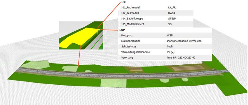
The classification of areas in the BIM model is visible in Fig. 4 where all protected areas are
presented in light green, work sites along the stretch are light brown, and storage sites for top
soil are olive green. Using the example of the protected area marked in yellow, it becomes
clear that landscape classifications in the BIM model are linked with information. With the
building component code (BTC) for example, the existing model structure for the respective
class can be comprehended. This assures the coordination of different component models and
close cooperation of the planners in the BIM coordination model. Specific characteristics that
were already entered in Autodesk Civil 3D are visible in the landscape planning (LAP) rubric.
On the basis of the integrated UwbB submodel, the environmental issues considered during
the construction phase can be easily conveyed to other project participants in the BIM coor-
dination model. This offers the chance to improve protection of the surrounding landscape
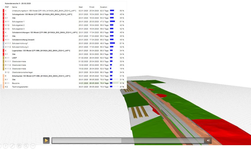
during construction work.350 Journal of Digital Landscape Architecture · 6-2021 Fig. 4: Submodel UwbB in BIM coordination model 3.5 4D Scheduling Another advantage of using BIM is seen in the so-called 4D planning. Here, various land- scape classifications of the sub-model UwbB are linked with scheduling. On this basis, a 4D construction workflow visualization can be produced. For example, areas bordering the con- struction site can be presented with their according protection status over time. The same is true for protective fences that need to be erected and then taken down again, for the setup of work and storage areas, and for clearing the building site. The depiction is presented as a table as well as diagram, and is clearly illustrated through the visualization as animation of the changes in the 3D model. Fig. 5: Submodel UwbB – 4D Visualization
I. Brückner, M. Remy: BIM Model Landscape_Open Spaces                                       351

On the basis of this 4D visualization, potential conflicts of time between the building plan
and specific environmental requirements can easily be recognized in the BIM model and
therefore avoided. This also aids others involved in the project, such as route planners and
civil engineers, carry out the various stages according to landscape and environmental con-
servation.
A further step would be to realize the second submodel, Impact Mitigation and Composition
Measures (AuG), according to the methods presented. It is to be expected that the coordina-
tion of different construction phases using 4D visualization would be beneficiary here as
well. Information required during the operation phase would be essential for the successful
development of the AuG submodel.

4    Discussion and Outlook
The necessity of integrating demands of landscape and environmental planning in BIM pro-
cesses has already been recognized and formulated. SHILTON (2018) discusses how the Brit-
ish approach to digital twin and the three levels of BIM can be carried out in landscape design
and emphasizes the necessity of an IFC standard for landscape elements. WIK et al. (2018)
present a Norwegian standardization project with a hierarchy of objects for infrastructure and
land design with the goal of integrating this into international standards, allowing developers
to create the necessary support for landscape objects in their software. Another approach is
to convert CAD and BIM data to GIS formats and combine it with GIS datasets so that the
necessary environmental analyses can be performed. An appropriate workflow is presented
by SCHALLER et al. (2017) using the example of the Autobahn A99 expansion in Munich.
CARSTENS (2019) reports on the improvement of interfaces between BIM and GIS.
In the future, the phase of operations and maintenance should come increasingly into focus
because exactly here lies the greatest potential for an increase in value in the “green” sector.
The increased integration of BIM and GIS could make an important contribution. The goal
of green space management would be to increase the quality of maintenance and with this
the quality of the appearance of the roadside vegetation. A special challenge for further re-
search would be to find a workable approach of taking into account the development of veg-
etation over time.
The transition to the 3D planning presented here means considerably more effort in terms of
landscape and environmental planning, especially in the initial phase. The participation in
BIM cannot just be self-serving, rather is only justifiable through significant improvement in
the course of the project. This requires an explicit definition of the desired BIM goals. Using
the example of the BIM pilot project A10/A24 and the defined applications of UwbB and
AuG within the framework of the landscape management implementation plan, the ad-
vantages for integrating landscape and environmental planning into existing BIM processes
is clear. By means of the central storage in the Landscape_Open Space Model, communica-
tion with other project participants is faster, more direct, and more understandable. With this,
the chance arises that landscape increases in value using the BIM method in the construction
program, and that landscape and environmental protection can be improved during the build-
ing phase.
352                                         Journal of Digital Landscape Architecture · 6-2021

References
BERGER, M. & ARUP (2020), BIM & GIS Integration. BIM & GIS für Hochbau und Infra-
   struktur. buildingSMART Webinar, 25.06.20.
BERNEBURG, R. (2000), Landschaftspflegerischer Ausführungsplan Teil 1: Erdbau- und In-
   genieurbauwerke. Kassel.
BORRMANN, A. & HEUNECKE, O. (2020), BIM für den Infrastrukturbau. In: DVW E. V. &
   RUNDER TISCH GIS E. V. (Eds.), Leitfaden Geodäsie und BIM Version. 2.1. Bühl, Mün-
   chen, 33-48.
BUILDINGSMART (2021), IFC4.3 RC2 – Release Candidate 2 [Draft].
   https://standards.buildingsmart.org/IFC/DEV/IFC4_3/RC2/HTML/ (22.02.202).
BUILDINGSMART-FACHGRUPPE BIM-VERKEHRSWEGE (2020), BIM-Klassen der Verkehrs-
   wege. bSD Schriftenreihe Heft 1.01. bSD Verlag, Berlin.
BIM4INFRA2020 (2019), Leitfäden, Muster und Handreichungen.
   https://bim4infra.de/handreichungen/ (22.02.202).
BIM DEUTSCHLAND – ZENTRUM FÜR DIE DIGITALISIERUNG DES BAUWESENS, Website.
   https://bimdeutschland.de/ (22.02.202).
BMVI – Bundesministerium für Verkehr und digitale Infrastruktur (2015), Stufenplan Digi-
   tales Planen und Bauen – Einführung moderner, IT-gestützter Prozesse und Technologien
   bei Planung, Bau und Betrieb von Bauwerken.
   https://www.bmvi.de/SharedDocs/DE/Publikationen/DG/stufenplan-digitales-
   bauen.pdf?__blob=publicationFile (22.02.202).
BRÜCKNER, I., MAßLING, N., WOZNIAK, M. & THIEME-HACK, M. (2019), How to Develop a
   BIM Workflow for Landscape Architecture – A Practical Approach. Journal of Digital
   Landscape Architecture, 4-2019, 122-130.
CARSTENS, A. (2019), BIM & GIS – New Dimensions of Improved Collaboration for Infra-
   structure and Environment. Journal of Digital Landscape Architecture, 3-2018, 236-240.
KÖNIG, J., AMANN, J., BORRMANN, A. et al. (2016), Wissenschaftliche Begleitung der BMVI
   Pilotprojekte zur Anwendung von BIM im Infrastrukturbau – Materialsammlung.
OTTO, K. (2019), 2. Stammstrecke München. Das digitale Infrastruktur-Großprojekt für Mün-
   chen und die Region – BIM/GIS Integration – Anwendungen bei der 2. Stammstrecke
   München. DB-Netz. BIM-World, München.
REMY, M. (2020), Entwicklung einer Methode zur Integration der landschaftspflegerischen
   Planung bei mit der BIM-Methode umgesetzten Straßenbau-Projekten. Studienarbeit For-
   schungssemester, Master Landschaftsarchitektur, Hochschule Osnabrück.
TSCHICKARDT, T. & KRAUSE, D. (2019), BIM im Verkehrswegebau am Beispielprojekt „Ver-
   fügbarkeitsmodell A 10/A 24“. Bautechnik, 96 (3), 259-268.
SCHALLER, J., GNAEDINGER, J., REITH, L., FRELLER, S. & MATTOS, C. (2017), GeoDesign:
   Concept for Integration of BIM and GIS in Landscape Planning. Journal of Digital Land-
   scape Architecture, 3-2017, 102-112.
SHILTON, M. (2018), Digital Futures – BIM in LANDSCAPE Design: A UK Perspective.
   Journal of Digital Landscape Architecture, 3-2018, 114-121.
WIK, K. H., SEKSE, M., ENEBO, B. A. & THORVALDSEN, J. (2019), BIM for Landscape – A
   Norwegian Standardization Project. Journal of Digital Landscape Architecture, 3-2018,
   241-248.
You can also read