Blowing the whistle on the climate of the Great Barrier Reef - Watts Up With That?
←
→
Page content transcription
If your browser does not render page correctly, please read the page content below
Blowing the whistle on the climate of the Great Barrier Reef
A synopsis of research by Dr. Bill Johnston
Main points
Locations of weather station at Cairns, Townsville and Rockhampton are misspecified by
Bureau of Meteorology metadata. Step-changes in maximum temperature caused by site
moves and changes (or adjustments related to site changes) are ignored or misrepresented
to imply the climate has warmed when it hasn’t.
There is no evidence that warming or climate change threatens or is likely to threaten
Great Barrier Reef ecosystems. Populist hysterical doomsayer-claims of impending
catastrophe linked to anthropogenic warming are unfounded.
An open public inquiry into the costly misdirection of research priorities by the Australian
Research Council and the consequent misallocation of millions of taxpayer dollars to
frivolous pursuits based on false notions about the climate is urgently needed.
Introduction
Weather stations at Rockhampton, Townsville and Cairns were part of the Aeradio network setup
in 1939 by Amalgamated Wireless (Australasia) on behalf of the Civil Aviation Board to track
aircraft along Australia’s major air routes and forecast and advise of weather conditions en route
(disturbances, wind-strength and direction, temperature and humidity profiles etc.).
Staff consisted of proficiency-certified radio operators/technicians and weather observers and
forecasters trained by the Weather Bureau in Melbourne. From June 1940 until June 1946 Aeradio
was conscripted as a section of the Royal Australia Air Force (RAAF) and when demobilised, air
traffic control transferred to the Department of Civil Aviation (DCA) (and later became Flight
Services) while met-staff moved to the Weather Bureau within the Department of the Interior
(which later became the Bureau of Meteorology (BoM)). During WWII the United States Weather
Bureau and the United States Army Air Force (USAAF) also operated meteorological facilities at
some Australian airfields including Townsville and Rockhampton.
Aerial photographs and documents and plans in the National Library and National Archives of
Australia (NLA and NAA) show unequivocally that post-WWII site moves and changes have been
misrepresented to imply the climate has changed and warmed. Following is a synopsis of
ongoing research on the climate of the Great Barrier Reef.
Discussion
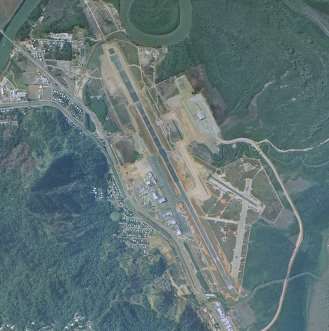
The Cairns Aeradio office was adjacent to the control tower beside the apron and main runway in
the northwestern sector of the aerodrome (Figure 1). The instrument enclosure with Stevenson
screen was adjacent to the apron about 30 m northeast of the office, not 1000 m southeast (at
Latitude -6.8872o Longitude 145.7572o) as stated in site-summary metadata.
Instead of moving the enclosure to a section of reclaimed mangrove-swamp north of the office in
1962, it relocated to a 2-metre high mound near the center of the airport in 1966 and from there
about 200 m to another mound before September 1983 to be out of the way of a new taxiway
(Figure 2). As one site was bulldozed while the other was built and there is no data missing,
another site must have operated in the interim. The 1983 aerial photograph shows the likely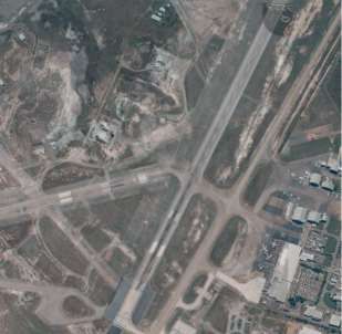
2

position of a fourth site on reclaimed land on the western side of the runway in the vicinity of
where the current automatic weather station (AWS) and met-office is located. A maximum
temperature (Tmax) step-change (1.01oC) in 1986 probably marks the end of when data were
adjusted to account for the move to the second mound.
Aerial photographs show the current met-office and radar was built before October 1994 by which
time the second mounded site was abandoned. Adjusting for the 1986 step-change leaves no
residual trend or cycles and no evidence that the climate has changed or warmed.

                                                                                       o        m
                                                                                   h
                                                                                       t
                                                                                            mo

Figure 1. Cairns control tower (t), operations centre ((o) behind) and the Aeradio met-office (mo) in c. 1959 (left).
                                                                                                              1
The Stevenson screen was located in a met-enclosure (m) north of the Aeradio office facing the apron (NAA
Barcode 16012351 p. 155), while (h) is the WWII-era hanger. (Airside photograph courtesy of the Civil Aviation
                                                               2
Historical Society; aerial photograph portion of QAP0298012 ; 30 June 1952.)

           sp
                                                                                  s4
                        s1          s2
                                                                                       sp
                                                                                           s1       s2

                                                                                                         s3

Figure 2. Cairns airport in 1968 (left) (portion of QAP1774012) and 1983 (QAP4193016) showing the location of the
original Aeradio site (S1), a site proposed but rejected in 1962 (Sp), the 1966 site near the anemometer (S2), that site
moving out of the way of a new taxiway in 1983 (S3) and that while neither site could have been operating another
site (S4) appears to have opened near where the current AWS is located (at that stage the new met-office had not
been built). The main runway was extended before 1952 and 1962 and was being extended further in 1983.

1
    NAA Barcodes can be searched at http://soda.naa.gov.au/barcode/
2
    https://qimagery.information.qld.gov.au/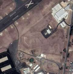
3

ACORN-SAT1 metadata states "Observations have been made at the airport (031011) since 1943”
and that the only move was "1.5 km northwest (to the other side of the runway)” in December
1992, but its not true. Metadata ignored that the original site beside the apron moved to the
mound in the middle of the airport in 1966 then to another mound before September 1983.
Effects of those moves appear to be adjusted-out of the data. Metadata also does not mention the
fourth site identified in the September 1983 aerial photograph or that the 230-litre Stevenson
screen was replaced with a 60-litre one on 4 October 2005.
The Townsville Aeradio office moved from the Ross River landing strip to the civil aviation
precinct on the eastern side of the runway at the RAAF aerodrome at Garbutt in 1940 (Figure 3).
Aerial photographs and archived documents and plans show the Aeradio office met-enclosure
probably moved once before the screen was relocated near a radiosonde hut east of the 1949
operations center in 1953/54. After it was blown over by Cyclone Agnes in March 1956 the
replacement screen was apparently reinstated in a pre-existing met-enclosure behind the office.

                                                    s3
                                T
                                             mo          s2
                          pen                                                                    ATC?

                                                                                                          s3 bg

                  ANA                                                       T
                                                                                                               drain
                 Ansett                                                                    mo
                 s?
                       Civil precinct
            Aeradio
            path
          s1
                                              RAAF

Garbutt 10Sqn print 5005, 1 February 1952                     QAP15231119, 1 July 1965.
(https://nla.gov.au/nla.cat-vn4602275).
Figure 3. Locations of weather station sites (S) near the 1940 Aeradio office (left) and the 1949 meteorological office
(mo). A plan indicates the original site was probably a fenced compound indicated by S ?. The Stevenson screen
apparently moved from S1 to the vicinity of the radiosonde hut (S2) in 1953/54 and after it was damaged in March
1956 its replacement relocated to the met-enclosure behind the office (S3) where it remained until December 1969.
The previous operations centre became the terminal (T) and the building to the north appears to be an air traffic
control centre. Bare ground (bg) east of S3 may affect observations.

Following protracted negotiations with the RAAF, a 100-foot square 1-metre high mound was built
on the western side of the runway in 1968. Instruments were set-up in 1969 and observations
transferred there from January 1970. Another site near the 1954 met-aids office apparently
operated before 1976. The screen moved again (150 m or so west) when that office was
demolished and replaced, before finally relocating to the current AWS on its 2 m high mound in
December 1994 (Figure 4).
According to ACORN-SAT metadata: “Observations have been made at Townsville Airport since
1942. There are no documented moves until one of 200 m northeast on 8 December 1994, at

1
    Australian Climate Observations Reference Network – Surface Air Temperature (ACORN-SAT)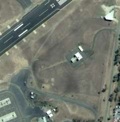
4

which time an automatic weather station was installed", but its not true. Archived files, plans and
aerial photographs show the site moved at least six times before December 1994. While some
changes had no impact, moves in 1953/54 and 1970 were ignored to imply the climate changed
and warmed when it didn't. Furthermore, although no buildings existed west of the runway before
1954 and the site moved from S5 when the 1954 RadioAids building was demolished; as if to
rewrite history, site-summary metadata places the 1940 Aeradio site at Latitude -19.2492o,
Longitude 146. 7647o, which is site S6 in Figure 4.
Moving the site in 1953/54, 1970 and 1994 accounts for all the warming in Tmax data (0.55oC
median-rainfall adjusted). Adjusting correctly for those changes leaves no residual trend, cycles or
step-changes attributable to the climate.

                                                                                  s7
        N
                                                                    s6           1995 MetWatch

                               1954 MetAids                                         1954 MetAids
                                                                           s5
                                                                                 1970 s4
                                                                         1954 tower
                                      an

                         1970 s4
                         mound
                                                                                                 T    s3
    1954 tower
                                                                                                 mo

                                    runway >>

https://nla.gov.au/nla.cat-vn4602323; Run 10, print   QAP32238379 (23 June 1976) rescaled and overlaid on
CAS 623 (19 October 1972)                             QAP5831015 (30 June 2000)

Figure 4. There were no buildings on the western side of the runway before the RAAF/DCA tower and MetAids
buildings were constructed in 1954. Observations transferred from S 3 to the mound (S4) from January 1970;
however, the resulting step-change was ignored to imply the climate changed. (Filled trenches link remote
anemometers (an) and radar to the control centre and tower.) An aerial photograph (QAP5268201) shows the 1954
MetAids office was demolished before 23 August 1995 and as the site was unreclaimed-swamp, it was sometime
later the site moved to S6.

The Rockhampton Aeradio office (and US Weather Bureau office) was north of the aerodrome
runways and the weather station with Stevenson screen was near the WWII garrison and canteen
on the aerodrome boundary (Figure 5). The site moved about 450m southeast to near its present
position before July 1956 and aerial photographs show both sites were observed concurrently
possibly until 1963. In 1993 the site was apparently moved away from the SatCom ground station
(visible in an October 1989 aerial photograph), which was probably installed in 1986. The earliest
Google Earth Pro satellite image (13 September 2003) shows the current screen is 30 m from
extensive hardstanding that wasn’t there in March 1999 (Figure 6).
ACORN-SAT metadata states: “The site has been operating since 1939. A site move (80 m
northeast) took place on 1 April 1993; an automatic weather station was installed at this time and
became the primary instrument on 1 November 1996”, but it’s not true. Documents, plans and
aerial photographs unequivocally show the original site was on the northern boundary of the
WWII aerodrome and it’s likely the Bureau adjusted for the move to near the middle of the airport
5
using overlap data. A step-change in 1986/87 aligns with rollout of the Australian aviation satellite
communication system (SatCom) by the Civil Aviation Authority. Although the screen was only
30 m away, it was not moved to a new mounded-site until April 1993. A 60-litre screen replaced
the previous 230-litre one on 22 March 2000 and subsequent data are contaminated by nearby
hardstanding. Site-related changes account for 1.30oC of warming in Tmax data (median-rainfall
adjusted) and there are no residual cycles, changes or warming attributable to the climate.
7
met 6
5
4
1 3
2
X
apron
MetAids?
Rockhampton ‘drome 27 October 1943, Rockhampton 12 July 1956 (https://nla.gov.au/nla.cat-
https://nla.gov.au/nla.cat-vn4602301, V1045) vn2153709 (DOCA collection) 2Sqn 246, print 5004)
Figure 5. Rockhampton RAAF 1943 (left). WWII-era buildings cross-referenced to maps are: (1) signal square and (2)
control tower; (3) office, store, hanger and fuel facilities (powerhouse behind); (4), Aeradio-met; (5), W/T and Ops
(USAAF); (6), armoury; (7), canteen and detention quarters. Other aerial photographs in the DCA series
(https://nla.gov.au/nla.cat-vn2153709) indicate that while a new met-enclosure was established at ‘X’ before 1961,
the original site was monitored possibly until 1965.
Discussion and conclusions
Cairns, Townsville and Rockhampton temperature datasets consist of untrending segments
disrupted by step-changes caused by site changes and after site-change effects are accounted for
no residual trends or changes are attributable to the climate. As the climate has stayed the same
since the 1940s it’s not true that Great Barrier Reef ecosystems are threatened by ‘a changing
world'1. There is also little likelihood of the situation changing markedly in the future.
Alarmist storytelling based on modelling2 is not trustworthy, while populist campaigns invoking
the false notion the climate is rapidly changing, such as by the ARC Centre of Excellence for Coral
Reef Studies, lack merit. For instance, there is no empirical evidence that “reefs are increasingly
threatened … and ... challenged by accelerating, human-induced environmental changes"3; or that
“organisms are projected to face unprecedented rates of change … due to anthropogenic
climate‐change"4. Furthermore, studies such as "Designing connected marine reserves in the face
1
https://www.coralcoe.org.au/responding-to-a-changing-world
2
E.g. Lewis, King and Mitchell (2017) (https://doi.org/10.1002/2017GL074612)
3
https://www.nature.com/articles/s41598-018-27891-3
4
https://doi.org/10.1111/gcb.132876
of global warming”1 play to the biases of the Australian Research Council not to the reality that the
climate has neither changed nor warmed.
mo
mo Sc
Sc
?
?
X SatCom
SatCom
X
Google Earth Pro image 13 September 2003 Google Earth Pro image 1 December 2018
Figure 6. Google Earth Pro satellite images show changes in the vicinity of the Rockhampton weather station from
13 September 2003. The site moved from the northern boundary of the airport to the vicinity of the position
marked ‘X’ in about 1956. The screen (Sc) is said to have moved 80 m northeast on 1 April 1993. However, it is more
likely that it relocated to the position marked with a question mark when the SatCom was installed. SatCom ground
stations and associated heat emitting electrical cabinets were installed at 94 airports across Australia in 1986/87.
Although it’s desirable and necessary to conduct on-going investigation and monitoring of the
Reef, it is essential that research be based on rigorously analysed hard-data so it is trustworthy
and adds to our storehouse of unbiased knowledge. Rivers of money mostly from taxpayers spent
each year by a flotilla of organisations may be miss-spent. Its apparent for instance, that the
Australian Research Council, the Great Barrier Reef Foundation, the Global Change Institute, James
Cook University, the Marine Park Authority, CSIRO, the Government of Queensland, Universities of
Queensland, NSW, Melbourne and ANU and drum-beating advocates like WWF, Greening
Australia, GetUp!, the Purves Environment Fund and the Climate Council have not independently
verified that climate change and global warming is detectable individual weather station datasets.
Graphic claims by WWF that “coral bleaching is the ghostly face of climate change..." and GBRF
that “climate change is the biggest threat to the Great Barrier Reef" are not substantiated and as
the climate hasn’t changed, episodes of bleaching are caused by something else. For their part, the
GBRF should return the half-billion dollars gifted to them without due process by Australia’s
former Prime Minister, Malcolm Turnbull so it can be reallocated to other priority areas of natural
resources research.
By ignoring site changes, the Bureau of Meteorology has gamed the data to show the climate has
warmed when it hasn't. An open public inquiry into the climate-change industry is long overdue.
About
Dr Bill Johnston is a retired natural resources research scientist with a career-long interest in
climate. The climate of the Great Barrier Reef is being audited using data for weather stations at
Rockhampton, Gladstone Radar, Townsville and Cairns (and Mackay and Bundaberg). The project
is unfunded.
1
https://doi.org/10.1111/gcb.13989You can also read