October 2020 Climate Summary - High Plains Regional Climate Center
←
→
Page content transcription
If your browser does not render page correctly, please read the page content below
October 2020 Climate Summary
The Cameron Peak Fire burns near Loveland, CO. Photo courtesy Becky Bolinger.
http://hprcc.unl.edu
Continued Dryness Intensifies Drought Conditions, Impacts
Overall, it was a dry month for the High Plains, with much of the region experiencing an intensification of drought
conditions. Perhaps the most notable impact of drought this month was the continuation of wildfires raging across
Colorado and, to a lesser extent, Wyoming. The Cameron Peak Fire, which ignited on August 13th, grew to become the
largest wildfire in Colorado history in October, surpassing the Pine Gulch Fire, which in August had just become the
largest in state history. At the time of this writing, the Cameron Peak Fire was 92 percent contained and had burned
208,913 acres in and around the Roosevelt National Forest. Another destructive fire, the East Troublesome Fire, ignited
on October 14th to the southwest of the Cameron Peak Fire. Warm temperatures, low relative humidities, and high
winds produced ideal conditions for this fire to spread quickly, growing by an astonishing 100,000 acres in one night.
This prompted the rapid evacuation of the town of Grand Lake. Unfortunately, two people died in this fire after being
trapped in their basement. The fire jumped the Continental Divide and into Rocky Mountain National Park, forcing
the closure of the Park and mandatory evacuations for the tourist town of Estes Park. Luckily, at the time of this writing,
the fire had not spread any further, sparing the town. Snowfall and cooler temperatures toward the end of the month
helped ease fire conditions. However, the fire was only 37 percent contained as of November 6th and it bears watching.
One benefit of the dryness was that producers were able to get out in the fields and harvest their crops. As of the end of
October, all High Plains states were ahead of the 5-year average for both corn and soybean harvest. In fact, Nebraska and
North Dakota had completed soybean harvest by the end of the month. Despite drought conditions, corn and soybeans
fared pretty well throughout the region. North Dakota and South Dakota are expected to have record corn yields this
year. However, drought conditions have caused winter wheat to struggle. More than 20 percent of the winter wheat crop
was rated poor or very poor in Colorado, Kansas, and Nebraska, and more moisture is needed to ensure sufficient growth.
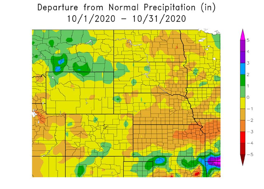
Temperature and Precipitation Overview
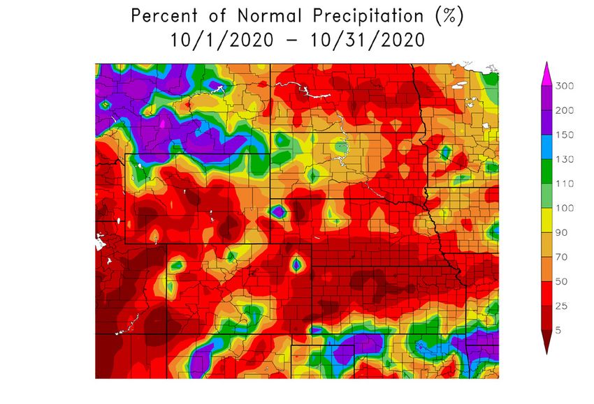
Above: Departure from 1981-2010 normal temperature (left) and percent of normal precipitation (right) for October 2020 in the High Plains region. Maps
produced by the High Plains Regional Climate Center and are available at: http://hprcc.unl.edu/maps/current .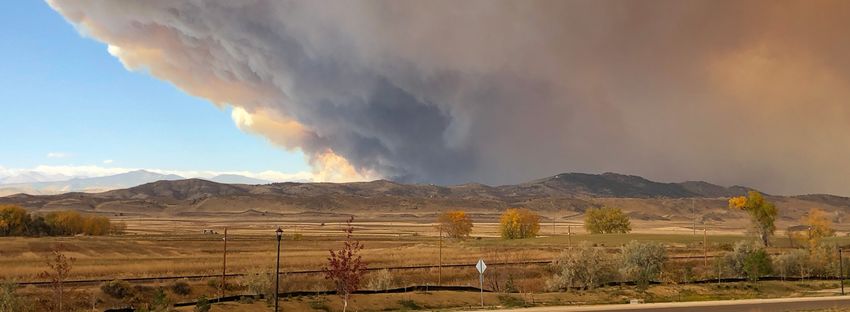
October 2020 Climate Summary
Precipitation
October was another dry month throughout the High                               Regional Precipitation
Plains region. Precipitation was less than 50 percent of
normal across much of North Dakota, Nebraska, Wyo-
ming, Colorado, eastern South Dakota, and northern Kan-
sas. Some locations received very little precipitation, which
placed this October among the top 10 driest Octobers on
record. Laramie, Wyoming and Akron, Colorado had their
driest, receiving only a trace of precipitation and 0.01 inch
(
October 2020 Climate Summary
Temperatures
Below-normal temperatures prevailed throughout a large                             Station Spotlight: Laramie, WY
part of the High Plains in October. Departures gener-
ally ranged from 2.0-8.0 degrees F (1.1-4.4 degrees C)
below normal, with the Dakotas experiencing the great-
est departures. Numerous locations throughout the re-
gion ranked among the top 10 coolest Octobers on re-
cord, with several locations in the Dakotas ranking among
the top 5 (see page 6 for more details). The only area
that experienced above-normal temperatures in Octo-
ber was western and central Colorado, where departures
were up to 4.0 degrees F (2.2 degrees C) above normal.
October started off rather warm, with many locations expe-
riencing above-normal temperatures for the first half of the
month. However, the second half of October turned colder,          Above: Daily temperatures along with extremes and normals values
with much of the region experiencing daily departures of           since November 1, 2019 in Laramie, WY.
at least 20.0 degrees F (11.1 degrees C) below normal for
a few days. Not only did numerous locations break daily records for minimum temperature, but some places had their
coldest October temperature on record, including Akron, CO, Pueblo, CO, Goodland, KS, Chadron, NE, Scottsbluff,
NE, Rapid City, SD, and Laramie, WY. Temperatures reached as low as -10.0 degrees F (-23.3 degrees C) in Chadron
on the 26th, which crushed the previous record for lowest October temperature of 0.0 degrees F (-17.8 degrees C), set
just last year (period of record 1941-2020). In Laramie, the temperature plummeted to -26.0 degrees F (-32.2 degrees
C) on the 27th, obliterating the previous record of -18.0 degrees F (-27.8 degrees C) set in 1993 (period of record 1948-
2020). It is interesting to note that Laramie’s record for coldest November temperature is also -26.0 degrees F (-32.2
degrees C), occurring in late November, so to record a temperature this low nearly a month prior is quite impressive.

Drought Conditions
Dry conditions in October led to continued development and intensification of drought throughout the High Plains.
According to the U.S. Drought Monitor, the area experiencing drought (D1-D4) increased from approximately
62 percent to 71 percent over the course of the month. By the end of October, over 98 percent of the region was
                                                        experiencing drought or abnormal dryness (D0-D4).
                  U.S. Drought Monitor                                  Exceptional drought (D4) increased in areal coverage
                                                                        across Colorado, expanding into northwestern, southwest-
                                                                        ern, and central parts of the state. Extreme drought (D3)
                                                                        spread into eastern Colorado and further expanded in Wy-
                                                                        oming and the Nebraska Panhandle, reaching into south-
                                                                        western South Dakota and western Kansas. D3 developed
                                                                        in southeastern South Dakota as well. Severe drought (D2)
                                                                        expanded across western and central North Dakota, west-
                                                                        ern Wyoming, southern and eastern areas of Nebraska, and
                                                                        northwestern Kansas. Moderate drought (D1) developed
                                                                        in portions of central and eastern Kansas, while abnormally
                                                                        dry conditions (D0) developed across the rest of the state.
                                                                        Only minor improvements in drought conditions occurred
                                                                        in October. D3 was removed from eastern Nebraska and
                                                                        slightly reduced in southern Colorado and northern Wyo-
   The U.S. Drought Monitor is produced as a joint effort of the U.S.
                                                                        ming. Meanwhile, D1 was reduced in northeastern and
   Department of Agriculture (USDA), National Drought Mitigation
                                                                        west-central South Dakota. Localized precipitation in
   Center, U.S. Department of Commerce, and the National Oceanic and
                                                                        mid-October brought relief to eastern Nebraska, while
   Atmospheric Administration (NOAA). For current Drought Monitor
                                                                        other areas were fortunate to receive enough precipitation
   information, please see: http://droughtmonitor.unl.edu/.
                                                                        from the late-October winter storm to improve conditions.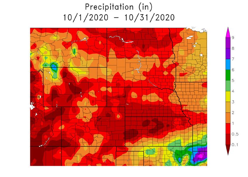
October 2020 Climate Summary
Climate Outlooks
According to the Climate Prediction Center, La Niña con-                          Temperature Outlook
ditions are present in the Pacific and a La Niña Advisory is
in effect. La Niña is expected to continue through the win-
ter, with about a 60 percent chance of persisting into spring.
Learn about how La Niña is expected to impact the Missouri
Basin region from the 2020 briefing on our ENSO page:
https://hprcc.unl.edu/enso_reports.php. For more informa-
tion about ENSO, check out the ENSO blog here: https://
www.climate.gov/news-features/department/enso-blog.
According to the National Weather Service’s long-range
flood outlook, there is less than a 50 percent chance of
long-range flooding across the High Plains through
January. Normal wildland fire potential is expected                              Precipitation Outlook
through December across the region, while above-nor-
mal wildland fire potential is favored for southern Kan-
sas and southeastern Colorado in January and February.
The seasonal temperature and precipitation outlooks be-
low combine the effects of long-term trends, soil mois-
ture, and when applicable, the El Niño Southern Os-
cillation cycle (ENSO). To learn more about these
outlooks, please see: http://www.cpc.ncep.noaa.gov.
Temperature
The November-January temperature outlook indicates
                                                                                     Drought Outlook
an increased chance of above-normal temperatures for
western, central, southern, and eastern portions of the
contiguous U.S. In the High Plains, this includes Colo-
rado, Kansas, the majority of Wyoming and Nebraska, and
southwestern South Dakota. Below-normal temperatures
are anticipated in northwestern Washington. Elsewhere,
there are equal chances for above-, below-, and near-nor-
mal temperatures during the November-January period.
Precipitation
The precipitation outlook for the next three months calls for
a higher probability of above-normal precipitation across
northern portions of the contiguous U.S. from Washington
to Minnesota. In the High Plains, this includes North Da-
kota, northern and central South Dakota, and the northern
half of Wyoming. Below-normal precipitation is anticipat-        Above: The three-month temperature probability outlook (top), the
ed across the southern U.S., as well as the central Plains.      three-month precipitation probability outlook (middle), and the U.S.
In the High Plains, this includes Kansas, central and            Seasonal Drought Outlook (bottom). For more information on these
southern Colorado, and southern Nebraska. Elsewhere,             outlooks, produced by the Climate Prediction Center, see:
there are equal chances for above-, below-, and near-nor-        http://www.cpc.ncep.noaa.gov.
mal precipitation during the November-January period.
Drought
The October 15th U.S.Seasonal Drought Outlook indicates that drought is expected to persist and further develop through-
out much of the West, the Plains, the Midwest, and the Southeast. In the High Plains, drought persistence is likely, with
further development possible in Nebraska and much of Kansas. Drought may improve or be removed in the Pacific North-
west and in the Northeast. However, drought is not expected to improve in any areas of the High Plains through January.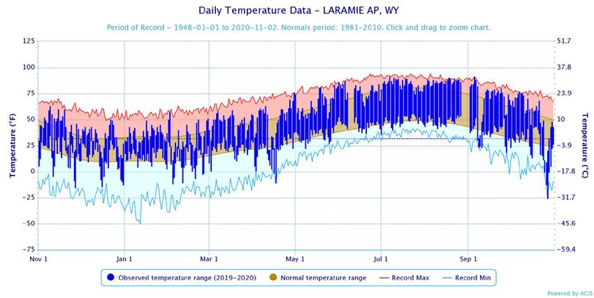
October 2020 Climate Summary
Station Summaries: By the Numbers
 Colorado                                       Temperatures (degrees F)                                                                        Precipitation (inches)
                                                Averages                                          Extremes                                      Totals
                                                Max          Min         Mean        Depart       High        Date         Low         Date     Obs      Depart    % Norm

 Akron Washington County Airport                62.5         31.9        47.2        -3.0         87          10/09+       0           10/27    0.01     -1.10     1
 Alamosa San Luis Airport                       67.4         22.8        45.1        2.0          80          10/14        1           10/27    1.03     0.35      151
 Colorado Springs Municipal Airport             66.8         35.2        51.0        1.6          87          10/14+       1           10/27    0.25     -0.57     30
 Denver International Airport                   66.3         33.4        49.8        -1.1         87          10/06        4           10/26    0.26     -0.76     25
 Grand Junction Walker Field Airport            70.1         37.5        53.8        0.8          82          10/14+       11          10/27    0.59     -0.47     56
 Pueblo Memorial Airport                        70.3         32.8        51.5        -0.3         94          10/14        -8          10/27    0.67     -0.05     93

 Kansas                                         Temperatures (degrees F)                                                                        Precipitation (inches)
                                                Averages                                          Extremes                                      Totals
                                                Max          Min         Mean        Depart       High        Date         Low         Date     Obs      Depart    % Norm

 Concordia Municipal Airport                    66.7         43.5        55.1        -0.3         94          10/07        22          10/26    0.12     -1.80     6
 Dodge City Regional Airport                    68.5         39.3        53.9        -2.7         96          10/07        18          10/27+   1.34     -0.40     77
 Goodland Renner Field                          64.4         31.7        48.1        -3.8         93          10/09        0           10/27    0.23     -1.14     17
 Topeka Municipal Airport                       65.5         41.2        53.4        -3.2         94          10/07        27          10/26    0.36     -2.67     12
 Wichita Mid-Continent Airport                  66.6         43.0        54.8        -3.5         92          10/07        24          10/26    2.06     -0.72     74

 Nebraska                                       Temperatures (degrees F)                                                                        Precipitation (inches)
                                                Averages                                          Extremes                                      Totals
                                                Max          Min         Mean        Depart       High        Date         Low         Date     Obs      Depart    % Norm

 Chadron Municipal Airport                      59.8         27.9        43.8        -3.8         92          10/08        -10         10/26    0.17     -1.14     13
 Grand Island Airport                           63.5         37.1        50.3        -1.9         91          10/09        18          10/27+   0.08     -1.78     4
 Lincoln Municipal Airport                      62.3         36.6        49.5        -3.7         88          10/11+       16          10/27    0.40     -1.57     20
 Norfolk Karl Stefan Airfield                   59.7         34.3        47.0        -4.0         87          10/09+       14          10/27+   0.56     -1.51     27
 North Platte Regional Airport                  64.5         30.1        47.3        -1.8         95          10/09        5           10/27    0.38     -1.17     25
 Omaha Eppley Airport                           60.7         38.2        49.5        -3.7         88          10/09        20          10/26    1.02     -1.13     47
 Valentine Miller Field                         61.2         29.9        45.6        -2.9         91          10/09        -4          10/27    0.79     -0.46     63

 North Dakota                                   Temperatures (degrees F)                                                                        Precipitation (inches)
                                                Averages                                          Extremes                                      Totals
                                                Max          Min         Mean        Depart       High        Date         Low         Date     Obs      Depart    % Norm

 Bismarck Municipal Airport                     50.7         30.0        40.3        -4.5         78          10/06        8           10/26    0.73     -0.52     58
 Fargo International Airport                    48.9         28.8        38.8        -6.7         75          10/09        11          10/27+   1.07     -1.08     50
 Grand Forks International Airport              49.2         27.5        38.3        -4.8         75          10/11        15          10/27    0.37     -1.60     19
 Theodore Roosevelt Airport                     49.6         25.6        37.6        -6.2         77          10/08        -1          10/26    0.31     -0.92     25
 Williston International Airport                47.8         26.9        37.4        -5.6         81          10/10        2           10/26+   0.48     -0.44     52

All data are preliminary and subject to change. + indicates multiple dates, latest date listed. * indicates some missing data for the period.
Data are retrieved through the Applied Climate Information System (ACIS) and are available online through the CLIMOD system.
For more information please contact us: http://www.hprcc.unl.edu/contact.php.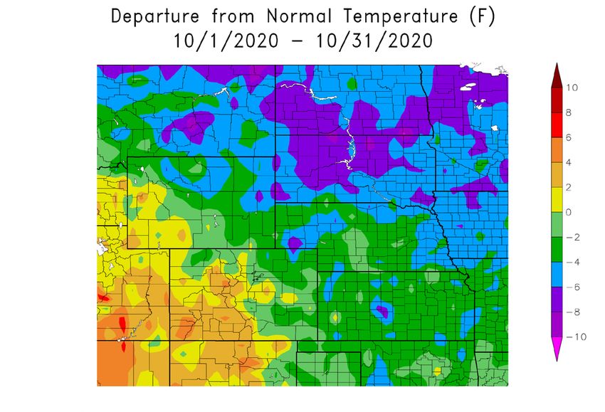
October 2020 Climate Summary
 South Dakota                                    Temperatures (degrees F)                                                                        Precipitation (inches)
                                                 Averages                                         Extremes                                       Totals
                                                 Max         Min         Mean         Depart      High         Date        Low          Date     Obs      Depart    % Norm

 Aberdeen Regional Airport                       52.6        29.5        41.1         -4.1        86           10/09       -3           10/26    1.27     -0.72     64
 Huron Regional Airport                          54.1        30.5        42.3         -5.6        86           10/09       4            10/26    0.90     -0.89     50
 Pierre Regional Airport                         54.2        31.1        42.6         -6.1        86           10/06       2            10/27    1.23     -0.42     75
 Rapid City Regional Airport                     55.2        28.4        41.8         -5.9        89           10/08       -7           10/26    0.95     -0.47     67
 Sioux Falls Joe Foss Field Airport              55.6        33.0        44.3         -3.6        86           10/06       13           10/27+   0.93     -1.24     43

 Wyoming                                         Temperatures (degrees F)                                                                        Precipitation (inches)
                                                 Averages                                         Extremes                                       Totals
                                                 Max         Min         Mean         Depart      High         Date        Low          Date     Obs      Depart    % Norm

 Casper Natrona County International AP          59.3        26.0        42.6         -2.6        82           10/06       -8           10/25    0.32     -0.79     29
 Cheyenne Municipal Airport                      59.1        29.8        44.5         -1.8        83           10/08+      0            10/27+   0.85     -0.08     91
 Lander Hunt Field Airport                       59.8        28.8        44.3         -1.3        82           10/08+      -9           10/26    0.68     -0.61     53
 Laramie Regional Airport                        55.3        23.5        39.4         -2.4        77           10/07       -26          10/27    T        -0.80     0
 Rawlins Municipal Airport                       58.1        28.4        43.2         -0.1        77           10/08       -12          10/26    0.34     -0.41     45
 Sheridan County Airport                         56.6        26.2        41.4         -4.1        85           10/06       -10          10/26    2.62     1.21      186

                                                             October 2020 Highlights
     Monthly Rankings
     Temperature in degrees Fahrenheit, Precipitation in inches
     Coolest                                         Temperature / Ranking                          Record / Year                                Period of Record
     Grand Forks, ND                                 38.3 / 4th coolest                             34.1 / 1925                                  1893-2020
     Dickinson, ND                                   37.6 / 5th coolest                             32.8 / 2002                                  1938-2020
     Williston, ND                                   37.4 / 5th coolest                             32.1 / 1919                                  1894-2020
     Aberdeen, SD                                    41.1 / 5th coolest                             37.6 / 2002                                  1893-2020
     Pierre, SD                                      42.6 / 5th coolest                             39.7 / 2002                                  1893-2020
     Rapid City, SD                                  41.8 / 5th coolest                             38.1 / 2019                                  1942-2020
     Chadron, NE                                     43.8 / 5th coolest                             39.5 / 2019                                  1941-2020
     Norfolk, NE                                     47.0 / 9th coolest                             38.9 / 1925                                  1893-2020
     Akron, CO                                       47.2 / 10th coolest                            39.5 / 1969                                  1937-2020
     Goodland, KS                                    48.1 / 10th coolest                            43.7 / 2009                                  1895-2020
     Wichita, KS                                     54.8 / 10th coolest                            49.0 / 1925                                  1888-2020

     Driest                                          Precipitation / Ranking                        Record / Year                                Period of Record
     Akron, CO                                       0.01 / DRIEST                                  0.02 / 2003                                  1937-2020
     Laramie, WY                                     Trace / DRIEST (tie)                           Trace / 1964                                 1948-2020
     Concordia, KS                                   0.12 / 5th driest                              0.02 / 1999                                  1885-2020
     Chadron, NE                                     0.17 / 6th driest (tie)                        0.04 / 1960                                  1941-2020
     Grand Island, NE                                0.08 / 9th driest                              0.00 / 1958+                                 1895-2020
     Topeka, KS                                      0.36 / 10th driest (tie)                       0.04 / 1952                                  1887-2020

All data are preliminary and subject to change. + indicates multiple dates, latest date listed. * indicates some missing data for the period.
Data are retrieved through the Applied Climate Information System (ACIS) and are available online through the CLIMOD system.
For more information please contact us: http://www.hprcc.unl.edu/contact.php.
About the High Plains Regional Climate Center
The High Plains Regional Climate Center (HPRCC) is one of six NOAA Regional Climate Centers (RCCs)
that has been providing timely climate data and information to the public for cost effective decision-making
since 1987. The HPRCC primarily serves the six-state region of Colorado, Kansas, Nebraska, North Dakota,
South Dakota, and Wyoming, but has also served people from all across the country and even throughout the
world. HPRCC operates under a three-tiered structure of climate services and works closely with other organiza-
tions on the local, regional, and national levels. HPRCC staff engage with a wide range of stakeholders includ-
ing K-20 education, the public, media, private industry, research, and state/tribal/federal entities, among others.
Much of the data and products found throughout this publication were built on the Applied Climate Informa-
tion System (ACIS) framework. ACIS was designed to manage the complex flow of information from climate
data collectors to the end users of climate data information. The main purpose of ACIS is to alleviate the bur-
den of climate information management for people who use climate information to make management decisions.
HPRCC is involved in the ongoing development and man-
agement of ACIS. In the spring of 2014, the RCCs released
a new website for ACIS. This new and improved website not
only contains descriptions of ACIS and the sources of data
found within, but also features real-world examples of how RCCs and external groups are using ACIS for their
particular climate data needs. In addition to these examples, there is extensive documentation and tutorials on how
ACIS can be used and accessed by external clients using Web Services. For more information see: http://rcc-acis.org.

Additional Summary Information for the High Plains
            Missouri River Basin Quarterly                        Midwest and Great Plains Monthly
            Climate Impacts and Outlook                            Climate and Drought Webinar

                                                               To sign up for future webinars:
                                                               https://www.drought.gov/drought/calendar/webinars

                                                               For an archive:
    For more information:                                      www.hprcc.unl.edu/webinars.php
    https://www.drought.gov/drought/dews/missouri-
    river-basin/reports-assessments-and-outlooks

Author Information
For questions, comments, or suggestions, please contact:
Crystal Stiles, Applied Climatologist
(402) 202-3320 - cstiles3@unl.edu
713 Hardin Hall, 3310 Holdrege Street
Lincoln, NE 68583-0997
http://hprcc.unl.edu
You can also read