Blue Trails: The Water is the Path! - Massachusetts Trails ...
←
→
Page content transcription
If your browser does not render page correctly, please read the page content below
Blue Trails: The Water is the Path!

                   Presenters:

             Sue Flint, Staff Scientist
   OARS (Assabet, Sudbury, and Concord Rivers)

                  Keith Davies
       Chicopee 4Rivers Watershed Council

                   Kristen Sykes
       Director of Conservation Strategies
           Appalachian Mountain Club

    Presented: Massachusetts Trails Conference
                November 4, 2017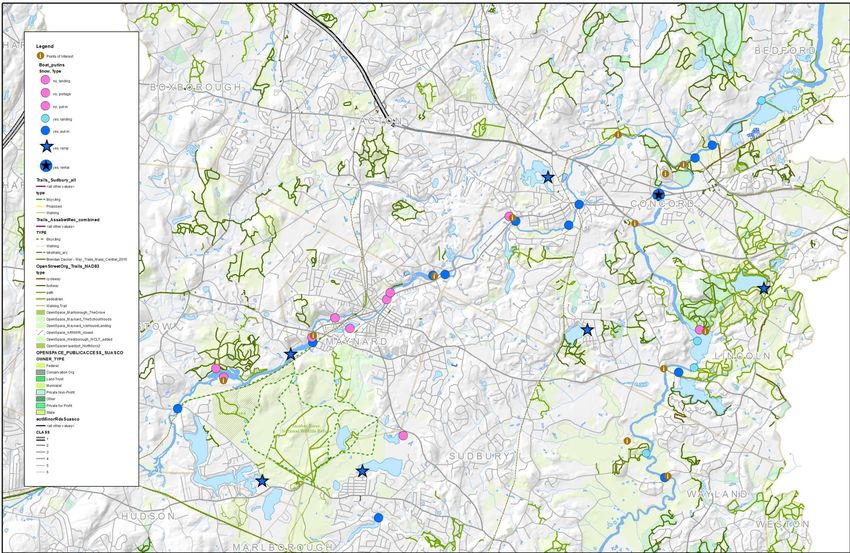
Sudbury,
Assabet &
 Concord
 Blue and
Green Trail

Sue Flint
OARS Staff Scientist
Science
 Advocacy
Stewardship

              Working to protect and
              preserve, the Assabet,
              Sudbury and Concord
              Rivers, their tributaries and
              watershed for wildlife and
              recreation since 1986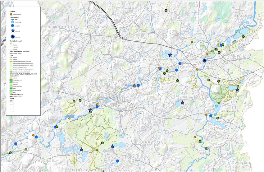
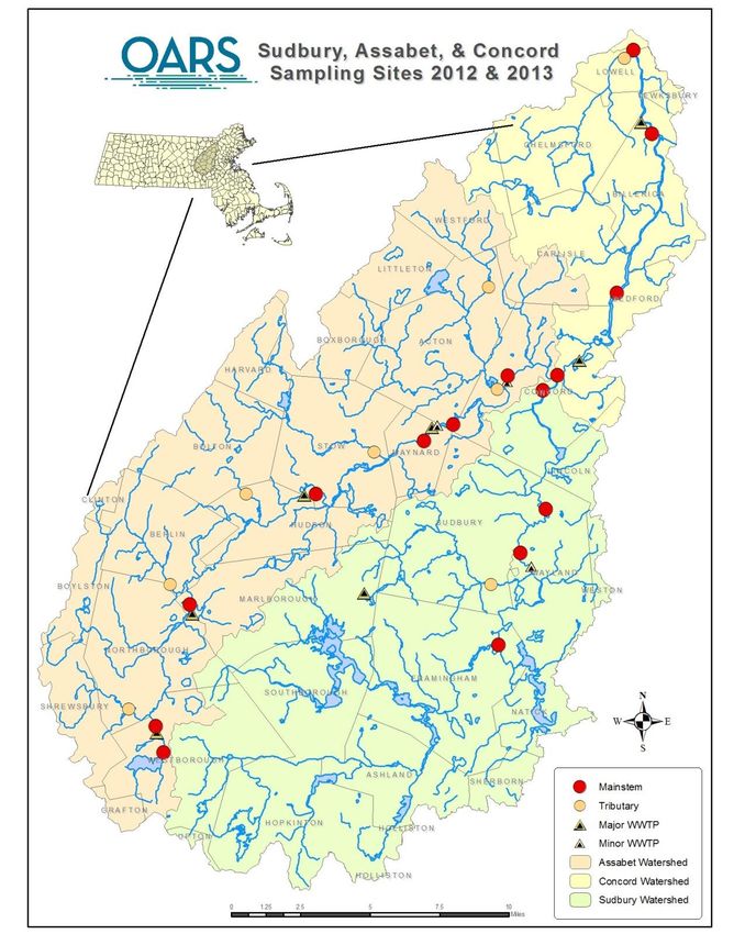
Background

Watersheds of Massachusetts
Watershed Statistics

• 399 sq. mi.
  watershed / 74
  miles of mainstem
  rivers

• Sections federally
  designated “Wild &
  Scenic”

• 7 Major
  wastewater
  treatment plants
    •   Westboro
    •   Marlboro West
    •   Hudson
    •   Maynard
    •   Concord
    •   Billerica
    •   Marlboro East
                    5
Eutrophication

                 Assabet River, Hudson, MA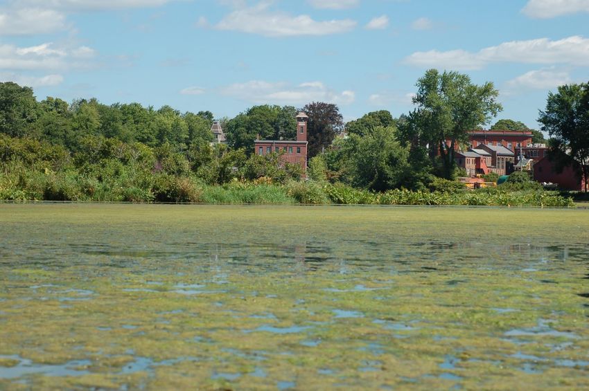
Progress

• Significant progress (WWTP
  upgrades completed in
  2012)

• Lower summer phosphorus
  concentrations in the water
  column of the mainstem
  Assabet River
• Which should lead to …
More days like this
Blue and Green Trail:
Awareness & Stewardship
• OARS’ VISION: “The Rivers should be navigable by canoes
  and kayaks, have good access, and have safe passage
  around the dams. A system of trails should allow hikers,
  anglers, and naturalist access to river banks and
  surrounding conservation lands.”
• Recreational maps of river & pond access points, suggested
  trips, and abutting walking trails –starting with the Assabet
  River

• DCR Trail Grant
    •   Recreational trail in Acton
    •   Handicapped friendly kayak dock in Maynard
    •   Signage for existing put-ins
    •   Educational signage for trails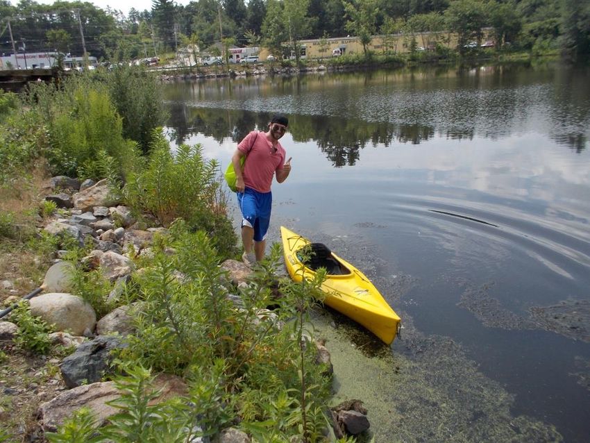
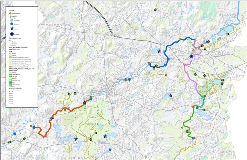
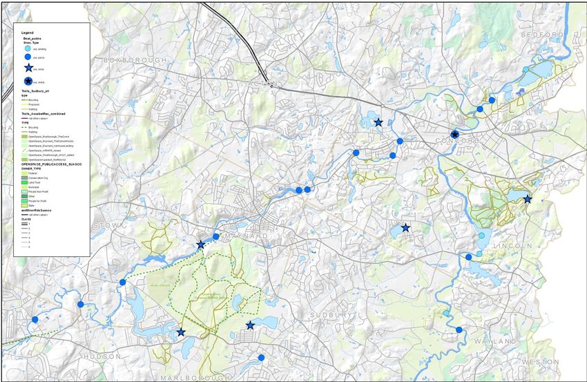
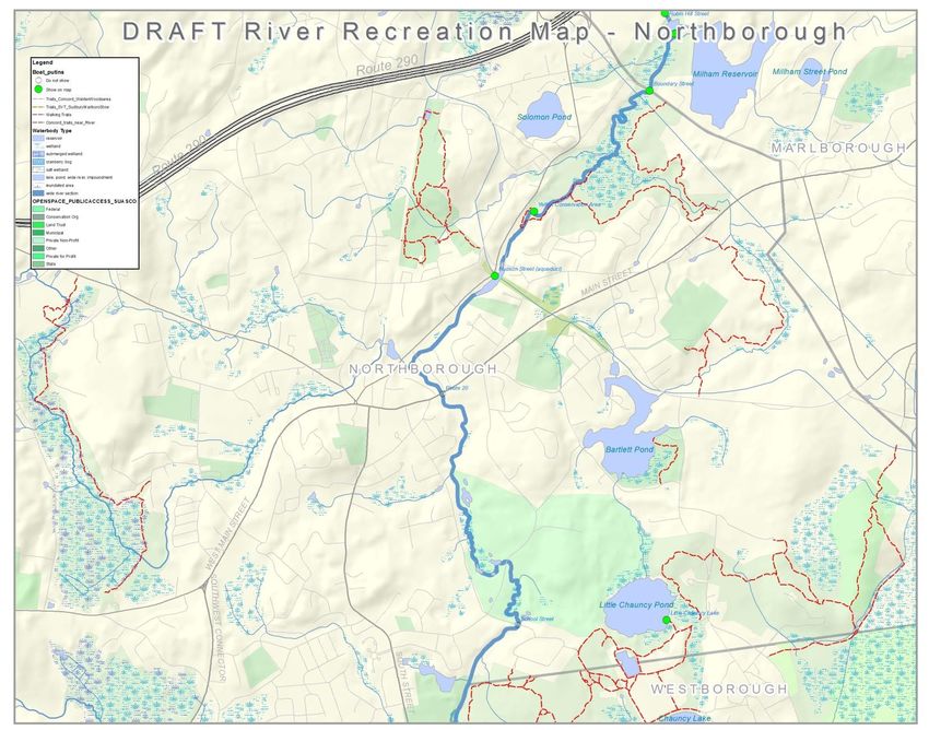
River Recreational Maps
• Original maps done more >10
  years ago

• Update information
  & paper maps

• Update the
  interactive online maps

• 2015 Assabet River

• 2016 Sudbury River

• 2018 Concord River (and all
  three maps together)          OARS & River Stewardship Council’s old maps
Information Collection

• Volunteers & staff
  collected put-in
  information (location,
  conditions, ownership if
  known, pictures)

• Collected GIS files for
  walking trails from towns
  and internet sources

• Put everything into one
  big GIS project

                                Summer intern surveying river access
GIS Data Sources: trails, open space, dams, access points
Meet with the towns with draft maps

Trails to include?

                                    Access points to
                                       include?
Select the information to include
Add Points of Interest and trailhead markers
Add our suggested paddles
Map Production: Print & Online

                                       www.oars3rivers.org/river_map/map

Or navigate to “maps” from OARS home page via “The Rivers/Recreation”
Work with designer for print & online www.maphero.com
Interactive Online Maps
Trip and Site Descriptions
Hiking Trail Links
Hiking Trail – Town Maps
Points of Interest & Directions
Collaboration
• In the process of creating the
maps, we talked with towns
• Came up with long list of
potential projects
(dependent on time and
funding)
• Secured DCR Trails grant for
2016-2017!
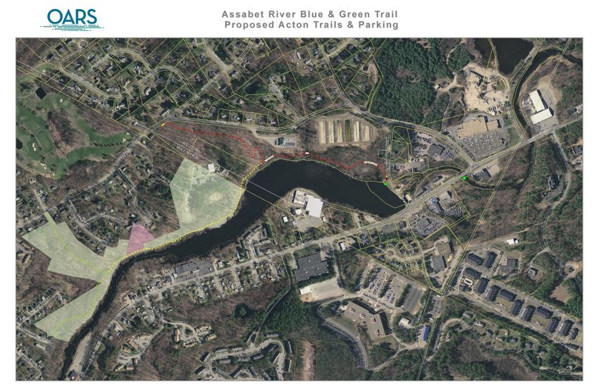
Summer assistant, Kevin, putting in at Old High Street, ActonDCR Recreational Trails Grant • Work with Acton Natural Resources on a new trail along the Assabet! • Work with Maynard Conservation Division to put in handicapped friendly dock • Install “Canoe Access” signs at various access points along the Assabet River • Work on getting permission to cross private land connecting the Maynard and Acton trails • Work to secure legal permission to use the Powdermill / Old High Street canoe access
New Trail

Unofficial Trail

                                                      Viewing boardwalk

               Existing Trail (Maynard)

 = new parking areas (spring 2018)
Acton Volunteers in Action: Building Trail
Bridge Building – Acton Trails Stewards

  Built by Acton Trail Stewards Chair, Bruce Rachman (Photo: Bettina Abe)
Handicapped Friendly Kayak
          Dock

                                  Assabet River
                                    Rail Trail

   = new parking for Rail Trail
Permitting
• Working within 200 ft of the river
• Wetlands Protection Act permit needed
• Acton and Maynard each filed NOIs (no
filing fee for the towns) and issued OOCs
• Working within a navigable waterway
• Chapter 91 License needed for the dock
and boardwalk/observation deck
• Acton & Maynard filed applications with
Mass DEP
• It was determined that Acton did not need
an ACOE Water Quality Certification for
the work (anything involving
dredging/filling)EZ Dock Installation
Ribbon Cutting – July 2017

From left to right: Julia Khorana (OARS), Andrew Scribner-MacLean (Maynard’s Assistant Administrator) and Michele Grenier
(Maynard Conservation Administrator), Senator Jamie Eldridge, Rep. Kate Hogan, and Alison Field-Juma (OARS). (Photo : Sue Flint)
USING THE DOCK
Visibility & Education
                    • DCR Trails project includes
                      funding to put “Canoe Access”
                      signs at Assabet River put-ins

                    • Interpretive signs at the trail
                      heads in Acton
                         • Pinehawk archaeological site
                           information
                         • Powdermill historic information
                           on the dam and mill site
Future work & collaborations?
• Improve access at key locations:
signage, invasives removal, erosion
control
• Add/improve portages around dams
(17 dams, none have designated
portage)
• Build trails / improve connections
between the river & trails
• Ensure stewardship of access points
and trails
• New collaborations?
• Lowell Parks and Conservation Trust
(Concord River Greenway Park)
• Bay Circuit Trail
• Rail Trails
• Other town & multi-town efforts Talbot Mill Dam, Billerica: no portage, no fish passage… yetThanks!
“Thanks!” to our hard-
working partners!
• Acton
• Bettina Abe & Tom Tidman
(Natural Resources)
• Department of Natural
Resources & DPW staff
• Acton Land Stewards
• Volunteers
• Maynard
• Michelle Grenier (Conservation
Division)Funding
• We’re grateful for funding
• Map Projects
• The Sudbury, Assabet &
Concord Wild and Scenic
River Stewardship Council
• Fields Pond Foundation
• The Sudbury Foundation
• REI
• ESRI Conservation
• Foundation for MetroWest
• Trails Project
• DCR Recreational Trails
Program
• In-kind funding from the
Towns of Acton and
Maynard and volunteersMillers River Watershed Council Chicopee 4Rivers Watershed Council Central Mass Blue Trails • Blue Trails • More than recreation • Making Connections
Blue Trails
           Protecting watersheds,
          connecting communities
• A blue trail (also known as blueway or water trail) is a
  dedicated stretch of river that enjoys special clean
  water safeguards and is a destination for fishing,
  boating and other recreation. Just as hiking trails are
  designed to help people explore the land, blue trails
  help people discover rivers. Blue trails provide a fun,
  exciting way to get kids outdoors, connect
  communities to treasured landscapes, and are
  economic drivers benefiting local businesses and
  quality of life.                         American Rivers
Why a Blue Trail? • Re/connect people and places • Promote healthy living • Protect the environment • Enhance local economies • Preserve history and community identity
Project features
1. Develop water trails in the Millers & Chicopee 4Rivers
2. Conduct trail surveys, map out trail features:
        natural & historic, recreation etc…
3. Prepare trail infrastructure
4. Hold trail work-parties
5. Design/Print a trail map/guide
6. Trail Day Celebration!
7. Establish and implement long term water quality monitoring program
8. Long term stewardship teams/open space protection
9. Enjoy the rivers!
Get people engaged!
A trail has an identity people can adopt & care for.
Documenting the trail creates a baseline and let’s people
know special features to visit on their outings.
Stewardship teams ensure long term care for the resource.
Monitoring water quality let’s people know the water is
healthy.
Quaboag Blue Trail - Map
The Story
Chicopee Blue Trail
Portage challenge
           Google Maps
                                                  Area where benched trail
    Proposed(Collins(Dam(Portage(c/o(C4RWC(       would be made.
    (
    !

                                 p
                                 orta
                                    gep
                                      ath               T
                                                        akeo
                                                           ut

                         P
                         ut in

                                              !

                                                      Barrel!line!
Millers River Blue Trail #2
MRBT #1
Making it happen!
• Work & Play!
Trail stuff
Stewardship
The future?
• Ware River Blue Trails
• Swift River Blue Trail
• QRBT #2
• Millers Quick Water
• Better access for all.
Thanks!
See you on one of our Central Mass Rivers!
Get out on the Mighty
 Connecticut River:
 Paddle, Camp, Explore
We’ve Got History!
AMC has a long been a leader in paddling in the
Northeast and helped popularize the sport in the U.S.

Appalachia’s first report of a major paddling trip
appeared in 1889: “Canoeing the Penobscot,” by Miss
M.E. Hardwick and Miss E.L. Sampson. The authors
detailed a month-long trip across Moosehead Lake and
down the West Branch of the Penobscot River.

In the late 1800’s and early 1900’s our members were
leading trips on tributaries of the Connecticut River
including the Millers, Farmington and Deerfield Rivers.

Paddling trip accounts by AMC members lead to the
first American whitewater handbook and guidebook,
Quick-Water and Smooth: A Canoeists Guild to New
England Rivers, published in 1935.
Explore the Connecticut River Watershed
Connecticut River Watershed Facts:

• 7.2 million acres in VT, NH, MA and CT
• 396 communities representing 2.4 million
  people
• Shares the same boundary as the Silvio O.
  Conte National Fish and Wildlife Refuge
• Designated as a National Blueway on May
  24, 2012
Connecticut River Paddlers Trail
• Currently, a series of primitive
  campsites and access points over
  300 miles from the river’s
  headwaters in New Hampshire to
  Connecticut.

• AMC is leading an effort to expand
  the trail south from NH and VT
  into MA and CT, creating a source
  to sea “thru paddle” starting in NH
  and ending at the Long Island
  Sound!
Extending the Paddlers' Trail into MA/CT

• In 2016 AMC’s Professional
  Trail Crew and volunteers built
  two new campsites in
  Montague and Whately, MA.

• In 2017 AMC built new
  campsites in East Haddam, CT
  and in Northampton, MA.
Steps to Building the Campsites

•   Assessment of potential campsites
•   Outreach to landowners
•   Presentation to town Conservation Commissions
•   Board of Health Approval for privy
•   Secure funding for campsite development – MA RTP grant and private foundations
•   Letters/email to campsite abutters
•   Development of campsite
•   Secure campsite adopter(s)
•   Soft promotion of campsite
See You On The River!
You can also read