BORROWDALE MARK RICHARDS - WALKING THE LAKE DISTRICT FELLS SCAFELL PIKE, CATBELLS, GREAT GABLE - Cicerone Press
←
→
Page content transcription
If your browser does not render page correctly, please read the page content below
WALKING THE LAKE DISTRICT FELLS

BORROWDALE
SCAFELL PIKE, CATBELLS, GREAT GABLE
  AND THE DERWENTWATER FELLS

        MARK RICHARDS

           CICERONE
CONTENTS
© Mark Richards 2021
Second edition 2021                                                              Map key. . . . . . . . . . . . . . . . . . . . . . . . . . . . . . . . . . . . . . . . . . . . . . . . . . . . 5
ISBN: 978 1 78631 038 5                                                          Volumes in the series. . . . . . . . . . . . . . . . . . . . . . . . . . . . . . . . . . . . . . . . . . 6
                                                                                 Author preface. . . . . . . . . . . . . . . . . . . . . . . . . . . . . . . . . . . . . . . . . . . . . . . 7
Originally published as Lakeland Fellranger, 2008                                Starting points. . . . . . . . . . . . . . . . . . . . . . . . . . . . . . . . . . . . . . . . . . . . . . . . 8
ISBN: 978 1 85284 540 7
                                                                                 INTRODUCTION . . . . . . . . . . . . . . . . . . . . . . . . . . . . . . . . . . . . . . . . . . . 13
                Printed in China on responsibly sourced paper                    Valley bases. . . . . . . . . . . . . . . . . . . . . . . . . . . . . . . . . . . . . . . . . . . . . . . . 13
                on behalf of Latitude Press Ltd                                  Fix the Fells . . . . . . . . . . . . . . . . . . . . . . . . . . . . . . . . . . . . . . . . . . . . . . . . 14
                                                                                 Using this guide. . . . . . . . . . . . . . . . . . . . . . . . . . . . . . . . . . . . . . . . . . . . . 15
A catalogue record for this book is available from the British Library.          Safety and access. . . . . . . . . . . . . . . . . . . . . . . . . . . . . . . . . . . . . . . . . . . . 17
All photographs are by the author unless otherwise stated.
                                                                                 Additional online resources . . . . . . . . . . . . . . . . . . . . . . . . . . . . . . . . . . . . 18
All artwork is by the author.
                                                                                 FELLS . . . . . . . . . . . . . . . . . . . . . . . . . . . . . . . . . . . . . . . . . . . . . . . . . . . . 19
                Maps are reproduced with permission from HARVEY Maps,            1 Allen Crags  . . . . . . . . . . . . . . . . . . . . . . . . . . . . . . . . . . . . . . . . . . . . 19
                www.harveymaps.co.uk                                             2 Armboth Fell  . . . . . . . . . . . . . . . . . . . . . . . . . . . . . . . . . . . . . . . . . . . 26
                                                                                 3 Base Brown . . . . . . . . . . . . . . . . . . . . . . . . . . . . . . . . . . . . . . . . . . . . 32
                                                                                 4 Bell Crags . . . . . . . . . . . . . . . . . . . . . . . . . . . . . . . . . . . . . . . . . . . . . . 38
                                                                                 5 Bleaberry Fell . . . . . . . . . . . . . . . . . . . . . . . . . . . . . . . . . . . . . . . . . . . 45
                            Updates to this Guide
                                                                                 6 Brandreth . . . . . . . . . . . . . . . . . . . . . . . . . . . . . . . . . . . . . . . . . . . . . . 54
   While every effort is made by our authors to ensure the accuracy of
                                                                                 7 Castle Crag . . . . . . . . . . . . . . . . . . . . . . . . . . . . . . . . . . . . . . . . . . . . . 63
   guidebooks as they go to print, changes can occur during the lifetime of an
   edition. Any updates that we know of for this guide will be on the Cicerone   8 Catbells . . . . . . . . . . . . . . . . . . . . . . . . . . . . . . . . . . . . . . . . . . . . . . . 72
   website (www.cicerone.co.uk/1038/updates), so please check before             9 Eagle Crag . . . . . . . . . . . . . . . . . . . . . . . . . . . . . . . . . . . . . . . . . . . . . 82
   planning your trip. We also advise that you check information about such      10 Glaramara  . . . . . . . . . . . . . . . . . . . . . . . . . . . . . . . . . . . . . . . . . . . . . 87
   things as transport, accommodation and shops locally. Even rights of way
                                                                                 11 Grange Fell  . . . . . . . . . . . . . . . . . . . . . . . . . . . . . . . . . . . . . . . . . . . . 98
   can be altered over time. We are always grateful for information about any
   discrepancies between a guidebook and the facts on the ground, sent by        12 Great Crag . . . . . . . . . . . . . . . . . . . . . . . . . . . . . . . . . . . . . . . . . . . . 112
   email to updates@cicerone.co.uk or by post to Cicerone, Juniper House,        13 Great End . . . . . . . . . . . . . . . . . . . . . . . . . . . . . . . . . . . . . . . . . . . . . 119
   Murley Moss, Oxenholme Road, Kendal, LA9 7RL.                                 14 Great Gable . . . . . . . . . . . . . . . . . . . . . . . . . . . . . . . . . . . . . . . . . . . 127
        Register your book: To sign up to receive free updates, special offers   15 Green Gable  . . . . . . . . . . . . . . . . . . . . . . . . . . . . . . . . . . . . . . . . . . 142
   and GPX files where available, register your book at www.cicerone.co.uk.
                                                                                 16 Grey Knotts  . . . . . . . . . . . . . . . . . . . . . . . . . . . . . . . . . . . . . . . . . . . 150
                                                                                 17 High Rigg . . . . . . . . . . . . . . . . . . . . . . . . . . . . . . . . . . . . . . . . . . . . . 158
                                                                                 18 High Seat . . . . . . . . . . . . . . . . . . . . . . . . . . . . . . . . . . . . . . . . . . . . . 166
Front cover: Gully view into the upper Newlands Beck valley from High Spy        19 High Spy  . . . . . . . . . . . . . . . . . . . . . . . . . . . . . . . . . . . . . . . . . . . . . 175
Title page: Skew Gill from the path south of Styhead Tarn
                                                                                 20 High Tove . . . . . . . . . . . . . . . . . . . . . . . . . . . . . . . . . . . . . . . . . . . . . 185
                                                                                 21 Maiden Moor . . . . . . . . . . . . . . . . . . . . . . . . . . . . . . . . . . . . . . . . . . 191
Map key
22 Raven Crag . . . . . . . . . . . . . . . . . . . . . . . . . . . . . . . . . . . . . . . . . . . . 198
23 Rosthwaite Fell . . . . . . . . . . . . . . . . . . . . . . . . . . . . . . . . . . . . . . . . . 203
24 Scafell Pike . . . . . . . . . . . . . . . . . . . . . . . . . . . . . . . . . . . . . . . . . . . 212 Key to route maps and topos
25 Seathwaite Fell . . . . . . . . . . . . . . . . . . . . . . . . . . . . . . . . . . . . . . . . . 226 Route on a defined path 12 Starting point
26 Sergeant’s Crag . . . . . . . . . . . . . . . . . . . . . . . . . . . . . . . . . . . . . . . . . 231 Route on an intermittent or
undefined path 4 Route number (on topos)
27 Ullscarf . . . . . . . . . . . . . . . . . . . . . . . . . . . . . . . . . . . . . . . . . . . . . . 237
28 Walla Crag . . . . . . . . . . . . . . . . . . . . . . . . . . . . . . . . . . . . . . . . . . . . 248
Fell summit featured in this guide
(on maps)
N
RIDGE ROUTES. . . . . . . . . . . . . . . . . . . . . . . . . . . . . . . . . . . . . . . . . . . 256
1 The High Spy ridge . . . . . . . . . . . . . . . . . . . . . . . . . . . . . . . . . . . . . . 256 Pike Fell summit featured in this
guide (on maps) 500
2 Around the Jaws of Borrowdale . . . . . . . . . . . . . . . . . . . . . . . . . . . . 259 0
m
3 The Gillercomb Skyline . . . . . . . . . . . . . . . . . . . . . . . . . . . . . . . . . . 263 Route number (on maps) 1:40,000
4 Glaramara ridge walk . . . . . . . . . . . . . . . . . . . . . . . . . . . . . . . . . . . . 267
Harvey map legend
More to explore. . . . . . . . . . . . . . . . . . . . . . . . . . . . . . . . . . . . . . . . . . . 271 Lake, small tarn, pond Contour (15m interval)
Index contour (75m interval)
Useful contacts. . . . . . . . . . . . . . . . . . . . . . . . . . . . . . . . . . . . . . . . . . . . 272 River, footbridge
Wide stream Auxiliary contour
A fellranger’s glossary. . . . . . . . . . . . . . . . . . . . . . . . . . . . . . . . . . . . . . 273
Narrow stream Scree, spoil heap
The Lake District Fells. . . . . . . . . . . . . . . . . . . . . . . . . . . . . . . . . . . . . . 277
Peat hags Boulder field
Marshy ground Scattered rock and boulders
Predominantly rocky ground
Contours change from brown to grey where
the ground is predominantly rocky outcrops, Major crag, large boulder
small crags and other bare rock.
O.S. trig pillar, large cairn
Improved pasture 805 Spot height (from air survey)
Rough pasture Dual carriageway
Fell or moorland Main road (fenced)
Open forest or woodland Minor road (unfenced)
Dense forest or woodland Track or forest road
Felled or new plantation Footpath or old track
Forest ride or firebreak Intermittent path
Settlement Long distance path
Boundary, maintained Powerline, pipeline
Boundary, remains Building, ruin or sheepfold, shaft
On moorland, walls, ruined walls and fences The representation of a road, track or footpath
are shown. For farmland, only the outer is no evidence of the existence of a right of way.
boundary wall or fence is shown.
5
Walking the Lake District Fells – Borrowdale
                                                                                                                AUTHOR PREFACE
     Volumes in the series                                    Area covered by this guide
                                                                                           This land of living dreams we call the Lake District is a cherished blessing
                                                                                           to know, love and share. As we go about our daily routines, we may take a
         Cockermouth                                                      Penrith
                                     KESWICK                                               fleeting moment to reflect that someone, somewhere, will be tramping up a
                                                                                           lonely gill or along an airy ridge, peering from a lofty summit or gazing across
                                                                                           a wind-blown tarn and taking lingering solace from its timeless beauty. The
                                                                                           trappings of modern life thrust carpet and concrete under our feet, and it is
                                 Keswick                                                   always wonderful to walk the region’s sheep trods and rough trails and to

                                                 PATTER
                                        LE
            BUTTERMERE                                                                     imprint our soles upon the fells. This series sets out to give you the impetus
                                     DA
                                   OW                                                      and inspiration to make space in your schedule to explore them time and

                                                       DALE
                                                                                           again, in myriad different ways.
                                 RR

                                                                                                However, the regular paths of long tradition deserve our care.
                              BO

                                                                 MARDALE                   Progressively many of the main paths are being re-set with cobbles and pitch-
         WASDALE
                                                                 AND THE                   ing by organisations such as Fix the Fells, to whose work you have contrib-
                                LANGDALE
                                            Ambleside            FAR EAST                  uted by buying this guide. But in many instances, the best consideration we
                                                                                           can give these pathways is rest. The modern fellwanderer should show a new
     N                           Coniston      Windermere
                                                                                           ‘green’ awareness by choosing to tread lightly on the land and to find new
                                                                                           ways around the hills. One of the underlying impulses of this guide is to pro-
                                                              Bowness
                                                                                           tect these beloved fells by presenting a diversity of route options for each and
                   CONISTON
 0       5                                                                     Kendal      every fell – and also, in this new edition, recommending ‘fell-friendly’ routes
          km
                                                                                           to each summit which are less susceptible to erosion.
                                                                                                Another feature of this latest incarnation of Fellranger, apart from the
                                                                                           smaller size to slip in your pocket or pack, is the addition of a selection of
                                                                                           inspiring ridge routes at the end of each volume for those of you who like to
                                                                                           spend a little longer with your head and feet in the heavenly realms, relishing
                                                                                           the summit views and the connections between the felltops, as well as some
                                                                                           accompanying online resources for readers with a digital bent.

                                                                                                                                                       Mark Richards
                                                                                                                                        www.markrichardswalking.co.uk

6Bird’s-eye view of Borrowdale from Rosthwaite Fell (photo: Maggie Allan)                                                                                                7
Walking the Lake District Fells – Borrowdale
    STARTING POINTS
Location              Description                  GR      Access   Ascents described          Location                Description                GR      Access   Ascents described
                                                                    from here                                                                                      from here
1    Rosthwaite       Car park in centre of      257 148   NT, B    Castle Crag, Grange        13   Seatoller          Car park next to bus     245 137   NT, B    Castle Crag,
                      village                                       Fell, Great Crag, High                             turning area                                Glaramara, Grey
                                                                    Spy                                                                                            Knotts, High Spy,
2    Quayfoot         NT car park in woods       253 168   NT, B    Grange Fell                                                                                    Rosthwaite Fell
                      off road bend                                                            14   Stonethwaite       Copious verge parking    261 138   FP       Allen Crags, Eagle
3    Grange-in-       Sizeable parking area      256 176   FP, B    Castle Crag, Catbells,                             beside road to hamlet;                      Crag, Glaramara,
     Borrowdale       beside B5289 N of                             Grange Fell, High Spy,                             fills quickly at peak                       Great Crag, Rosthwaite
                      village                                       Maiden Moor                                        times                                       Fell, Sergeant’s Crag,
                                                                                                                                                                   Ullscarf
4    High             Jetty served by the        252 197   L        Catbells, Maiden Moor
     Brandelhow       Keswick Launch                                                           15   Watendlath         NT car park in hamlet    276 163   NT       Bell Crags, Grange Fell,
     Jetty                                                                                                                                                         Great Crag, High Seat,
                                                                                                                                                                   High Tove, Ullscarf
5    Hawse End        Jetty served by the        251 213   L        Catbells
     Jetty            Keswick Launch                                                           16   Surprise View      Two generous parking     268 189   FP       Grange Fell, High Seat
                                                                                                                       areas in woods beside
6    Uzzicar          Large layby S of farm      232 217   FP       Catbells                                           road
                      access-track junction
                                                                                               17   Ashness Bridge     Large car park S of      269 196   FP       Bleaberry Fell, Grange
7    Chapel Bridge,   Sizeable layby beside      231 193   FP       Catbells, High Spy,                                bridge                                      Fell, High Seat, Walla
     Little Town      bridge (fills quickly at                      Maiden Moor                                                                                    Crag
                      peak times) or nearby
                      field at Little Town                                                     18   Kettlewell         Popular car park         267 195   NT, B    Grange Fell
                                                                                                                       beside B5289
8    Black Sail       Walk/bike-in youth         195 123   F        Brandreth, Great
     Youth Hostel     hostel at the head of                         Gable, Green Gable         19   Great Wood         Large car park in        272 214   NT, B    Bleaberry Fell, Walla
                      Ennerdale                                                                                        woodland E of B5289                         Crag

9    Gatesgarth       Farmer-owned car           195 150   PP, B    Brandreth, Great           20   Keswick (Lake      Large town-centre        265 233   PP, B    Bleaberry Fell, Walla
                      park with overflow in                         Gable, Grey Knotts              Road)              car park                                    Crag
                      yard behind buildings                                                    21   Tewet Tarn         Very limited verge       306 239   FP       High Rigg
10   Honister Pass    Large visitor-centre       225 135   PP,      Brandreth, Great                verge              parking on road bend
                      parking area on the                  NT, B    Gable, Green Gable,        22   St John’s in the   Parking area by          306 225   FP       High Rigg
                      pass (plus NT car park                        Grey Knotts                     Vale Church        church (give prefer-
                      beside YHA hostel)                                                                               ence to churchgoers)
11   Little           Generous layby on          230 136   FP, B    Grey Knotts                23   Causeway           Layby opposite           293 218   FP, B    Bleaberry Fell, High
     Gatesgarthdale   road bend beside                                                              Foot, Naddle       Causeway Foot Farm                          Seat
                      beck                                                                          valley
12   Seathwaite       Verge parking S of         235 123   FP       Allen Crags, Base          24   Rough How          Verge parking along      300 206   FP, B    Bleaberry Fell, High
                      Seathwaite Bridge and                         Brown, Brandreth,               Bridge             old road parallel to                        Seat, Raven Crag
                      in allocated field at                         Glaramara, Great End,                              A591
                      Seathwaite Farm                               Great Gable, Green
                                                                                               25   Legburthwaite      Verge/layby parking at   316 194   FP, B    High Rigg
                                                                    Gable, Grey Knotts,
                                                                                                    (A591 layby)       junction
                                                                    Scafell Pike, Seathwaite
                                                                    Fell                       26   Thirlmere Dam      Small parking area on    307 189   FP       Raven Crag
                                                                                                                       W side of dam

8                                                                                                                                                                                           9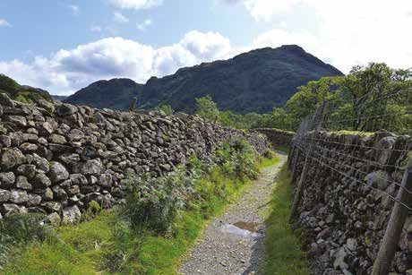
WSTARTING           POINTS continued
 alking the Lake District Fells – Borrowdale

 Location                Description                GR      Access   Ascents described
                                                                     from here
 27    Armboth           Large United Utilities   305 172   PP       Armboth Fell, High
                         car park with toilets                       Tove, Raven Crag
 28    Dob Gill          Large United Utilities   316 140   PP       Armboth Fell, Bell
                         car park with toilets                       Crags, Ullscarf
 29    Steel End         Small United Utilities   320 130   PP       Ullscarf
                         car park
 30    Old Dungeon       NT car park              286 061   NT, B    Allen Crags, Scafell
       Ghyll, Great                                                  Pike
       Langdale
 31    Brotherilkeld     Generous layby W of      210 011   FP       Scafell Pike
                         phonebox at the foot
                         of Hardknott Pass
 32    Wha House         Small car park N of      200 009   FP       Scafell Pike
                         Wha House Farm
 33    Wasdale Head      NT car park              182 075   NT       Scafell Pike
 34    Wasdale           Lots of rough parking    186 085   FP       Great End, Great
       Green             (but fills quickly in                       Gable, Scafell Pike
                         season)

FP – free parking
PP – pay parking
NT – National Trust (free to members)
B – on a bus route (in season)
L – served by the Keswick Launch (in season)
F – only accessible by foot or bike

10                                                                                          Scots pine on Castle Crag
                                                                                                                   11
Walking the Lake District Fells – Borrowdale Valley bases
INTRODUCTION
Valley bases
No valley better epitomises the romance of mountain Lakeland than
Borrowdale. From Keswick, venture past Derwentwater and through the
dramatic Jaws of Borrowdale to the traditional settlements of Rosthwaite,
Seatoller and Seathwaite or to Stonethwaite, the entry-point for the wild glen
of Langstrath. To the west the Newlands valley holds further allure, and to the
east lies the Thirlmere valley, offering quiet ascents onto the unfrequented
central ridge from Bleaberry Fell to Ullscarf. In between hides the upland
sanctuary of Watendlath.
Trees lend so much to the early charm, but with altitude you will find
raw scrawny fell country – domain of stocky Herdwick sheep – and mighty
crags: serious mountain terrain demanding the utmost respect and prepara-
tion. Many ascend the Scafell massif and Great Gable from Seathwaite-in-
Borrowdale, with such ascents requiring smart choices in regard to route,
timing and weather. This guide will help you make these choices, but sound
navigation and the proper use of a map are also essential skills.
Looking to the distant Blencathra from the main
walkers’ highway from Honister to Green Gable
12 Glaramara from Brandreth 13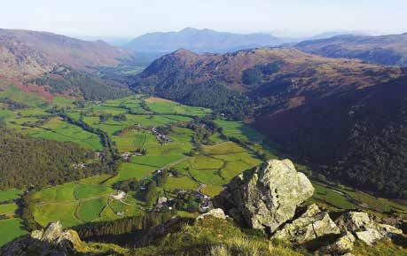
Walking the Lake District Fells – Borrowdale                                                                                                     Using this guide
Facilities                                                                        joint tyranny of boots and brutal weather. The dedicated and highly skilled
Keswick is known far and wide as the capital of Lakeland adventure. Easily        team, including volunteers, deserve our sincerest gratitude for making our hill
accessed, it has hotels, guest houses, B&Bs and humbler pitches to serve all      paths secure and sympathetic to their setting. It is a task without end, includ-
manner of preferences and budgets. Hotels, pubs and tearooms abound,              ing pre-emptive repair to stop paths from washing out in the first place.
reflecting the special place the region holds in people’s hearts.                      Bearing in mind that a metre of path costs upwards of £200, there is every
                                                                                  good reason to cultivate the involvement of fellwalkers in a cause that must
Getting around                                                                    be dear to our hearts… indeed our soles! Please make a beeline for www.
Until the early 1970s Keswick was served by a train from Penrith, but now the     fixthefells.co.uk to make a donation, however modest. Your commitment will,
car and bus are supreme. Throughout the year the 555, X5/X4 and Borrowdale        to quote John Muir, ‘make the mountains glad’.
Rambler bus services operate regularly along the primary valley roads, pro-
pelling you to and from the wondrous fells.                                       Using this guide
     Parking is not to be taken for granted anywhere in this popular park.        Unlike other guidebooks which show a single or limited number of routes
Always allow time to find an alternative parking place, if not to switch to a     up the Lakeland fells, the purpose of the Fellranger series has always been
different plan for your day or just set out directly from your door – perfectly   to offer the independent fellwalker the full range of approaches and paths
possible if you find accommodation within any of the main valleys. Always         available and invite them to combine them to create their own unique experi-
take care to park safely and only in laybys and car parks, not on the side of     ences. A valuable by-product of this approach has been to spread effects of
the narrow country roads. Consult the ‘Starting points’ table to find out where   walkers’ footfall more evenly over the path network.
the best parking places (and bus stops) are to be found. Note that although,          This guide is divided into two parts: ‘Fells’ describes ascents of each of
in general, one preferred starting point is specified for each route, there may   the 28 fells covered by this volume, arranged in alphabetical order; ‘Ridge
be alternative starting points nearby should you arrive and find your chosen      routes’ describes a small selection of popular routes linking these summits.
spot taken.

Fix the Fells
The Fellranger series has always highlighted the hugely
important work of the Fix the Fells project in repair-
ing the most seriously damaged fell paths. The mighty
challenge has been a great learning curve and the more
recent work, including complex guttering, is quite
superb. It ensures a flat foot-fall where possible, is easy
to use in ascent and descent, and excess water escapes
efficiently, minimising future damage.
     The original National Trust and National Park Authority partnership came
into being in 2001 and expanded with the arrival of Natural England, with
additional financial support from the Friends of the Lake District and now the
Lake District Foundation (www.lakedistrictfoundation.org). But – and it’s a big
but – the whole endeavour needs to raise £500,000 a year to function. This
enormous figure is needed to keep pace with the challenges caused by the

14                                                                                Lane to Rosthwaite (photo: Maggie Allan)                                     15
Walking the Lake District Fells – Borrowdale
its wider context. That said, beware of the green dashed lines on Ordnance
Survey maps. They are public rights of way but no guarantee of an actual
route on the ground. Take care to study the maps and diagrams provided
carefully and plan your route according to your own capabilities and the
prevailing conditions.
Please do not rely solely on your mobile phone or other electronic device
for navigation. Local mountain rescue teams report that this is increasingly
the main factor in many of the incidents they attend.
The author has taken care to follow time-honoured routes and keep
within bounds of access, yet access and rights of way can change and are
not guaranteed. Any updates that we know of to the routes in this guide will
be made available on the Cicerone website, www.cicerone.co.uk/1038, and
we are always grateful for information about discrepancies between a guide-
book and the facts on the ground, sent by email to updates@cicerone.co.uk
or by post to Cicerone Press, Juniper House, Murley Moss, Oxenholme Road,
Kendal, Cumbria, LA9 7RL.
Additional online resources 1 ALLEN CRAGS 784M/2572FT
Summit panoramas for all of the fells in this volume can be downloaded Climb it from Seathwaite 12, Stonethwaite 14 or Old Dungeon Ghyll
for free from the guide page on the Cicerone website (www.cicerone. (Great Langdale) 30
co.uk/1038). You will also find a ticklist of the summits in the Walking the Character Rugged and remote, yet with handy access from the high
Lake District Fells series at www.cicerone.co.uk/fellranger, should you wish point of the ancient pass between Great Langdale and
to keep a log of your ascents, along with further information about the series. Wasdale
Fell-friendly route 4
Summit grid ref NY 236 085
Link it with Glaramara or Great End
Part of Glaramara ridge walk
Defined by deep valleys and sustaining the 2000ft contour for more than two
miles, a ridge leads north from the saddle north of Esk Hause, with Glaramara
at its mid-point. Allen Crags forms its southernmost high point, the first rise on
a perennially popular fell-top trek. It’s a modest bag when set against the likes
of neighbouring Great End, but a good objective for those all-too-frequent days
when the Scafells are obscured by mist.
The best route climbs from the Grains Gill valley (1–5), from which aspect
the fell’s rougher and more characterful qualities are foremost. In truth, only
18 Allen Crags from Great End 19
Walking the Lake District Fells – Borrowdale                                                                                                         1 Allen Crags

from this side can the fell be considered a primary objective for a circular fell   Gill to form Grains Gill. Further upstream it is worth stepping aside to admire
walk. The greater ridge walk, via Allen Crags, Glaramara and Rosthwaite Fell,       the cascades. Stay with the modern hard trail to the saddle.
goes north from the saddle below Esk Hause, having come up from Stonethwaite             If you prefer a grassy climb, take a short diversion after the footbridge,
by way of lonely Langstrath (6) or by Grains Gill, or even from Seathwaite via      off to the left, on an old path. Bear half-left as you approach a second ford
Styhead Pass.                                                                       across a gill. A little-used grass path leads up the bank. Pass a small flat out-
                                                                                    crop and bear half-left (without a path) onto the narrow grassy moraine rigg

Ascent from Seathwaite 12 off map N
Adventurous options breaking pathless from the regular valley way

Via Allen Gill à4.5km/2¾ miles á610m/2000ft ¹2hr 25min
1 Follow the valley bridleway through the farmyard via gates,
advancing to Stockley Bridge, from where two handsome pack-
horse-bridge routes divide. After the hand-gate turn left, beside the
wall, on a path up Grains Gill. There are several options from this
point: Routes 2–5.
     2 Having followed Route 1, shortly after the next hand-
gate, with obvious path pitching, bear half-left down to a broad
wooden footbridge and then head upstream. It is easier to
remain at beck level initially. With the approach of the wooded
gorge, bear left up the bank to enjoy a grandstand view of the
waterfall in Ruddy Gill. Follow the moraine ridge. When you
come to Allen Gill follow it on the right bank, climbing steeply,
keeping to the grass until you reach the source, just below the
ridge path from Glaramara. Go right and pass immediately to
the right of High House Tarn, from whose northeastern edge
you can get a great view of the Langdale Pikes with the tarn
in the foreground. Even more photogenic is the tiny rock-girt
Lincomb Tarn, set among the outcrops just a little further up
(to the south). Follow the stony ridge path direct to the summit
cairn.

Via Ruddy Gill à4.7km/3 miles á610m/2000ft ¹2hr 40min
3 Having followed Route 1, the less taxing option is to stay
with the sheltered Ruddy Gill path, scene of considerable pitch-
ing work in recent years. This path advances over a footbridge where
the gill begins to race dramatically down a gully and plunges into Allen

20                                                                                                                                                                21
Walking the Lake District Fells – Borrowdale 1 Allen Crags
SCAFELL PIKE
ESK PIKE traversing wet ground between outcrops to gain the ridge path north of the
Ore
Gap Esk fell-top. Join the path and turn back south to the summit.
Hause
Angle Tarn ALLEN CRAGS
GREAT END 5 The normal course, having set out on the Grains Gill/Ruddy Gill
pa th fr om 5
Mickleden > 7 approach with Routes 1 and 3, is to ford Ruddy Gill as it bends left and
The
Band keep beside the red-soiled ravine, ignoring the right-hand branch path lead-
4 Sprinkling Tarn
ing directly to Esk Hause. At the shallow saddle cross-paths go left (north) up
o m ITE 6
Sty
ill
> High House
yG
h fr Tarn Head the loose trail to the summit.
p a t THWA 3
dd
E e c k
N
th B
Ru
STO t r a SEATHWAITE
gs
Lan GLARAMARA Re
d
2 FELL slopes of
Gi
ll
Styhead Tarn GREAT
GABLE
Ascent from Stonethwaite 14 off map NE
ll
Gi
Comb Head Gill
slopes of Via Langstrath à9km/5½ miles á685m/2245ft ¹3hr
ade
s
GREEN
yh
Grain
St
LOOKING GABLE
SOUTH slopes of
A ‘sneaking up’ process among scenery that encourages the mind to wander
bridle track from BASE too, allowing you to get away from it all
SEATHWAITE Taylorgill Force BROWN
1
6 Follow the main track from the hamlet. As you turn into the Langstrath val-
ley choose between the bridleway (east side), reached over the footbridge,
(ridge). Then, rising easily to and the footpath (west side); the former is better underfoot. All the really good
the skyline, bear right, cross- scenery – of which there is plenty – is exhausted by the time you reach the
ing two tiny gills. Mount the footbridge at the foot of Stake Beck. Cross the bridge and ignore the rising
boiler-plate slab above the bridleway, which takes the Cumbria Way into Great Langdale. Continue on
prominent outcrop to gain a the narrow trod running along the base of Rossett Pike. The path copes well
broad marshy shelf. Skirt this with the inevitable marsh. Where Allencrags Gill and the stream from Angle
to the right (west), passing a Tarn meet, ford and follow Allencrags Gill on an intermittent path, climbing
small cairn. Cross a further to Tongue Head. Turn right towards the saddle, where, setting its sights on
gill then bear right, passing Allen Crags, the path winds northeast to the top.
a small cairn, to regain the
modern path.
4 Just as the gill turns
sharp left (east) at the end
of Route 3 you can climb
off the main path onto an
attractive, undulating spine-
of-rock ridge (no path). With
the craggy slope of Allen
Crags ahead, bear half-left
Bridle path by Ruddy Gill
up the prominent grass ramp,
22 23Walking the Lake District Fells – Borrowdale 1 Allen Crags
Ascent from Old Dungeon Ghyll, Great Langdale 30 off map E
Via Rossett Gill à6.7km/4¼ miles á690m/2265ft ¹2hr 45min
A long valley walk-in connects you with the main thoroughfare up to the
hause.
7 From the Old Dungeon Ghyll car park advance with the valley bridle-
way along Mickleden to the footbridge, where the Stake Pass and Rossett
Gill paths fork. Go left. The old pony route is currently being enhanced with
sturdy pitching on the zig-zag beneath Bowfell’s high buttresses. The path
dips by the outflow of Angle Tarn and climbs Tongue Head to the Allen Crags
hause. A cross-wall wind-shelter just south of the hause (marked with a cross
on the HARVEY map) is a key landmark to locate. Turn right for the summit.
The summit
A single cairn on a small rock base marks this delightful top. The view is
special. The Langdale Pikes, Bowfell, Esk Pike, Great End and Great Gable all
feature large – a scene fit for a majestic fresco.
Allen Crags from Sprinkling Tarn
Safe descents you cross two intermediate tops separated by the depression at the head of
In deteriorating conditions aim to reach the saddle on the connecting ridge Red Gill. Cairns may lure you left from the trail for the fine westward view en
(with a cross-wall wind-shelter some 60 metres further S). It is SW of the sum- route to the cairnless rock summit, with its snug wind-shelter.
mit, a matter of eight minutes’ descent on a loose but obvious trail. Turn left
(E) for Langstrath (6) or – far better – Great Langdale (7) in 6.4km, or right (W) Great End à2km/1¼ miles â60m/195ft á195m/640ft ¹1hr
for Borrowdale, following Ruddy Gill (5, 3, 1) for just over 4.8km or continu- Descend SW to the saddle and follow the clear path SW, passing the wind-
ing via Styhead Pass for Wasdale Head in 6.4km (not mapped). shelter and rising to the multi-cairned Esk Hause. Bear right (W). The popular
trail leads up into the shallow hollow of Calf Cove. On gaining the brow bear
right (N), crossing the stone-free mid-ridge to either of the cairned tops.
Ridge routes
Glaramara à2.7km/1¾ miles â160m/525ft á130m/425ft ¹1hr 10min
Head N on the ridge path. This is one of those uncomplicated paths that
never seems to get going, never clear of rock long enough to really allow
you to stride out. The mid-point depression, with its cluster of pools around
High House Tarn, is a place to dawdle. Beyond, the ridge bulks further and
24 25You can also read