BROOKLANDS AERODROME & MOTOR RACING CIRCUIT GAZETTEER OF HERITAGE ASSETS - Brooklands Heritage Partnership - Radley House Partnership
←
→
Page content transcription
If your browser does not render page correctly, please read the page content below
BROOKLANDS AERODROME
  & MOTOR RACING CIRCUIT

GAZETTEER OF HERITAGE ASSETS
      Brooklands Heritage Partnership

     CONSULTATION COPY (June 2017)

         Radley House Partnership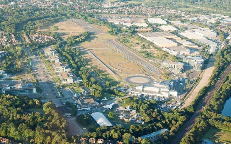
BROOKLANDS AERODROME & MOTOR RACING CIRCUIT                                                                  5670

GAZETTEER                                                                                            CONTENTS

          Introduction

          Statutory Designation Map

          Data Sheets

     A    Scheduled Monument
             Outer Circuit                                                                                  A1
             Members’ Hill including Test Hill, Air Raid Shelters & Bofors Anti-Aircraft Gun Tower          A2
             Aerodrome Road                                                                                 A3
             Campbell Circuit                                                                               A4
             Campbell Circuit Pits                                                                          A5
             ‘Vickers’ Bridge                                                                               A6
             Brooklands Memorial                                                                            A7

     B    Statutory Listed Buildings
              Former Brooklands Automobile Racing Club Clubhouse             Grade II*                      B1
              Former Members’ Hill Restaurant                                Grade II                       B2
              Former Flight Ticket Office                                    Grade II                       B3
              Former Brooklands Aero Clubhouse                               Grade II                       B4
              Bellman Hangar                                                 Grade II                       B5

     C    Locally Listed Buildings
             Shell Petrol Pagoda                                                                            C1
             Esso Petrol Pagodas (formerly Pratts Petrol Pagodas)                                           C2
             Press Hut                                                                                      C3
             Campbell Shed                                                                                  C4
             ERA Shed                                                                                       C5
             Racing Lock-ups                                                                                C6
             Dunlop Mac’s Bungalow                                                                          C7
             BP Petrol Pagoda                                                                               C8
             Jackson Shed                                                                                   C9
             Pill Box                                                                                       C10

     D    Other Non-Designated Assets
             Substation No. 23 (T222)                                                                       D1
             Stratosphere Chamber and Balloon Hangar/Supersonic Wind Tunnel                                 D2
             Acoustics Laboratory                                                                           D3
             Terracotta ‘Gate Statements’                                                                   D4

Cover Photographs:                                                Aerial photographs over Brooklands (16 July 2014)
                                                                               © reproduced courtesy of Ian Haskell

Brooklands Heritage Partnership             CONSULTATION COPY                            Radley House Partnership
Gazetteer: June 2017
                                             Page 2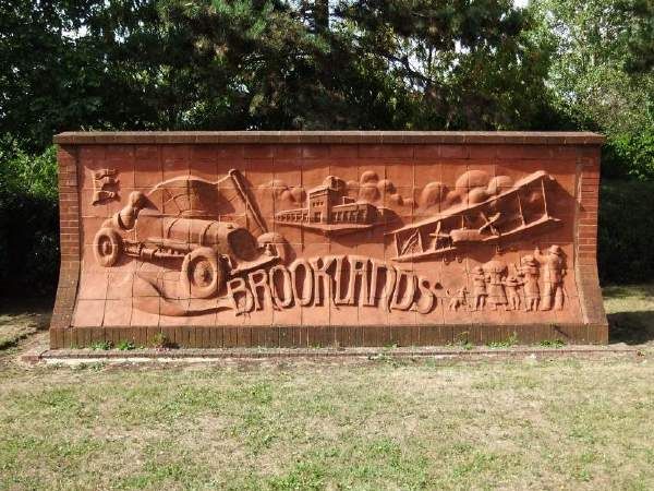
BROOKLANDS HERITAGE PARTNERSHIP 5670
BROOKLANDS AERODROME & MOTOR RACING CIRCUIT
GAZETTEER OF HERITAGE ASSETS INTRODUCTION
1.0 Introduction
1.1 This Gazetteer contains a series of data sheets, which record all designated and non-designated
heritage assets within the Brooklands Conservation Area, as well as a series of historic buildings
and structures which are believed to be of importance to Brooklands following the preparation
of the Brooklands Aerodrome & Motor Racing Circuit Conservation Management Plan.
1.2 The content of document is broken down into four principal sections, to reflect the type of
designation for each of the assets. These are as follows:
Scheduled Monument
Statutory Listed Buildings
Locally Listed Buildings
Other Non-Designated Assets
1.3 Separate data sheets have been prepared for each of the assets – with the Scheduled
Monument broken down into readily identifiable constituent elements. Each data sheet includes
a summary of its designation and function; a brief history and description; comments on its
significance and value; and reference to the recommendations included in the Conservation
Management Plan. They are then illustrated with historic (where available) and contemporary
photographs for record purposes. In addition, a thumbnail location plan is included to identify
the location and extent of the particular asset (shown in black) within the context of the
Brooklands Conservation Area boundary (shown in red), all other mapping information is omitted
for clarity.
1.4 The map over the page highlights the extent and location of the different assets within the
Brooklands Conservation Area.
Brooklands Heritage Partnership CONSULTATION COPY Radley House Partnership
Gazetteer: June 2017
Page 2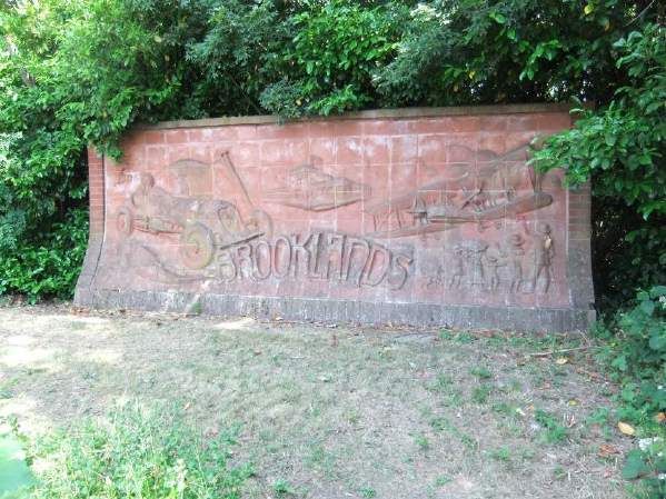
BROOKLANDS AERODROME & MOTOR RACING CIRCUIT 5670
GAZETTEER OF HERITAGE ASSETS APPENDICES
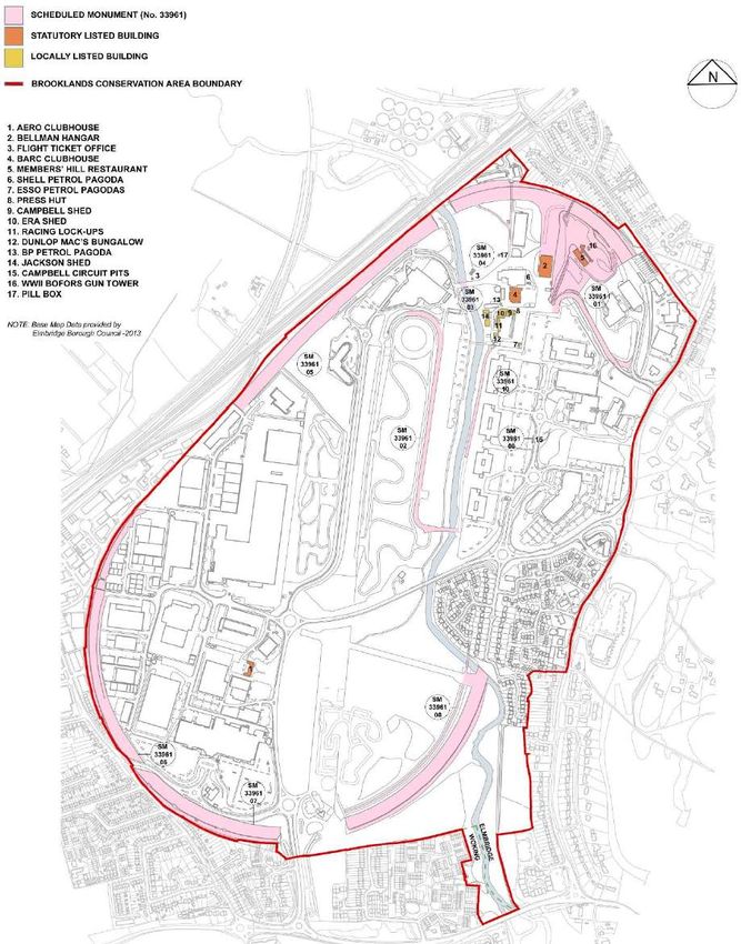
Plan of the Brooklands Conservation Area (not to scale)
identifying all statutory designations and locally listed buildings
[Original CMP Map Reference – 5670/SK1 which]
Brooklands Heritage Partnership CONSULTATION COPY Radley House Partnership
Gazetteer: June 2017
Page 3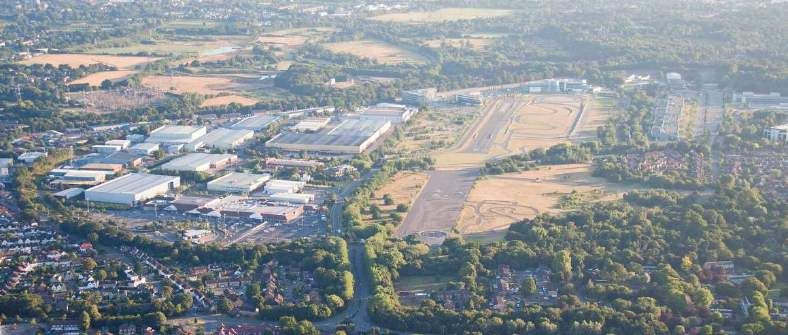
BROOKLANDS AERODROME & MOTOR RACING CIRCUIT
HERITAGE ASSETS GAZETTEER

Reference         Brooklands Motor Racing Circuit – Outer Circuit      Status     Scheduled Monument

Summary                                                                Location

Designation       SM33961 – 01, 05, 06, 07, 08
Reference:        Historic England
Date:             1907
Association:      Motor Racing
Function:         Originally race track, sections are still used for
                  vehicle demonstrations/teaching        with    the
                  remainder now just large sculptural features in
                  the landscape.

Scheduled:        17 January 1975

Amended:          7 January 2002

History and Description

Local landowner, Hugh Locke King of Brooklands House, Weybridge, was an enthusiastic supporter of
early motor racing and was frustrated by the lack of any race or test track in England. Following a trip to
Italy to see the Coppa Florio road race in 1905, he decided that the marshy land at Brooklands would be
an ideal location for a new permanent race track. Plans started to be drawn up in 1906, where it was
originally proposed to be a flat oval circuit, however Colonel Henry Capel Loftt Holden of the Royal
Engineers suggested that there should be banked corners which would allow speeds of up to 120mph to
be achieved in the tightest corners, which was only just slower than the world land speed record of the
time!

The track’s construction represented a considerable achievement in terms of the scale and complexity of
the civil engineering timescale to complete, as well as the pioneering use of concrete as a material
previously little used for road building. It was laid in small sections, using locally sourced aggregates,
cast directly over the sandy subsoil of the newly made up or cut ground. However, this pioneering use of
concrete also brought its own problems as from the day of opening, a recurrent feature of the track was
the poor quality of the concrete which required ongoing and often significant areas of repair and relaying
– typically on an annual basis during the winter periods, as only short-term ad-hoc gravel repairs were
possible during the racing season. This problem was also coupled with the instability of the underlying
base. Except for the Hennebique Bridge (see below), no reinforcement was incorporated within the
original concrete construction – it is understood this only began to be used within later areas of repair.

Clearance of the site began in the summer of 1906 using local labour, before being progressed by
construction company Price & Reeves from January 1907 onwards. Despite being beset with financial
problems, labour issues and not without local opposition, the construction project together with the related
infrastructure was completed ready for the inaugural race meeting on 6th July 1907. In a period of only
ten months the marshy farmland had been transformed with the felling of 30 acres of woodland, the
movement of 350,000 cubic yards of earth and the laying of an estimated 200,000 tons of concrete.

The overall oval form of the circuit built with the 6 inch thick concrete, was 100 feet wide (30m) for its
entire 2¾ mile (4.4 kilometre) perimeter length. It consisted of the two steeply banked bends at the
northeast and southwest ends (the Members’ or Home Banking and the Byfleet Banking respectively),
which were connected by the ‘Railway Straight’ on the northwest side and a soft reverse curve section the
southeast side – a straight was not achievable here as Locke King had already sold off the adjoining
parcels of land. Towards the southeast end of the Byfleet Banking, the ‘Fork’ was created to allow the ½

Brooklands Heritage Partnership               CONSULTATION COPY                        Radley House Partnership
Gazetteer: June 2017                                                                            A1 - Page 1 of 7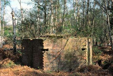
mile (0.8 kilometre) long Finishing Straight to follow a northerly axis and link directly to the Members’
Banking.

The River Wey presented a significant obstacle for the track at its north end. However, advice was swiftly
sought from L G Mouchel & Partners, who were the British agents for the Hennebique method, a
reinforced-concrete construction process which had been developed and patented by Francois
Hennebique in 1892. This resulted in the 180 feet span across the river being achieved with a pioneering
steel reinforced concrete structure consisting of five arches, which became known as the ‘Hennebique
Bridge’.

During the development of the design and the construction of the track, access for vehicles and
spectators were obviously important factors. This was principally achieved with two tunnels constructed
at the Weybridge end of the circuit. At the north end of the race track was the ‘Competitor’s Tunnel’ also
known as the ‘Shell Way Tunnel’ – a single carriageway for use by motor cars providing direct access to
the Paddock Area. The second tunnel known as the ‘Spectators’ Tunnel’, on the northeast side of
Members’ Hill, was for pedestrians and provided access for spectators through a series of three
interlinked parallel passageways.

From the official track opening on Monday 17th June 1907 by the Earl of Lonsdale, the north end of the
circuit with the Finishing Straight became the focal point of all motor racing activities and events held at
Brooklands. A major aspect of the Finishing Straight was that it provided vehicular access to the
Paddock and Clubhouse, which were both located towards the northern end on its western side, allowing
competitors to enter and exit the track. It was also used as a runway by aviation pioneer A.V. Roe for
testing his Roe 1 Biplane in 1907-08. Races were generally finished in front of the Clubhouse. Many, but
not all, of the Brooklands races by cars, motorcycles and even bicycles, were also started on the
Finishing Straight (in line with the convention of motor racing road circuits today). Having been originally
conceived with horse racing as the precedent, start lines for race meetings of all types were in many
different locations, or for races of different configurations, and which were not necessarily always run in
the ‘natural’ anti-clockwise direction.

National popularity of the track continued unabated until the outbreak of WW1 with intense public interest
in both motor racing generally, and the many record-breaking speed and endurance milestone
achievements at Brooklands. It was not until April 1920 that motor racing was able to return to
Brooklands, as the track had been left in such a poor state of repair as a result of 6 years of neglect. It
then continued in use over the following two decades with large attendances being maintained through to
the early 1930s, while it remained as the only permanent motor racing venue in England until the opening
of Donington Park in 1933 and the advent of road style racing (on an unbanked track).

In 1926, Brooklands held its first international motor race – the first British Grand Prix which raced in an
anti-clockwise direction and made use of the Finishing Straight, part of the Members’ Banking, the
Railway Straight and the Byfleet Banking, with chicanes added to sections of the Finishing Straight to
reflect the characteristics of a road circuit. A temporary scaffold footbridge was also erected to link the
Paddock to Members’ Hill for this event, which was replaced in 1927 by a single-span permanent
structure for the return of the event. However, neither turned out to be great successes with only 9
entrants taking part in 1926 and only 11 entrants in 1927, which led to it never being brought back to
Brooklands. Unfortunately, Hugh Locke King was unable to witness either of these events as on 28th
January 1926 he died at Brooklands House, passing his estate to his wife Ethel who continued to keep
the race track in use for a further 13 years. Through this inter-war era the rapid evolution of racing cars
continued, with track speeds increasing until the ultimate lap record of 143.44mph was achieved in 1935
by John Rhodes Cobb in his 24 litre Napier Railton.

The last ever race meeting was held on 7th August 1939, as in September 1939 the track closed in
response to the outbreak of World War Two. The Brooklands site was subsequently heavily developed
for defence and military aviation manufacturing activities - and motor racing was never to return, as the
damage caused during the war camouflaging and defending Brooklands against enemy bombing raids as
well as that from the growth of the aviation industry was too great.

Over the following decades as the aviation industry grew, sections of track were obscured or lost as
buildings were built across the top. Then as other developments within and around Brooklands took
place, further losses were inevitable. This initially included the loss of part of the Members’ Banking as a
result of a housing development off Locke King Road during the late1960s. Then as the aviation industry
came to an end and their factory sites were redeveloped, further losses occurred including: more of the
Members’ Banking (1984/85). Sections of the Byfleet Banking were lost as the industrial and commercial

Brooklands Heritage Partnership            CONSULTATION COPY                          Radley House Partnership
Gazetteer: June 2017                                                                           A1 - Page 2 of 7
areas were developed (1986 onwards) and the southern end of the Finishing Straight and The Fork
began to be lost as Vickers developed their factory site and built over these areas in the 1950s, before
the current commercial office and residential development led to the removal of any surviving sections.
The Hennebique Bridge was also removed, but as a result of storm and flood damage in 1968.

During the 1970s and 1980s the Brooklands Society (founded in 1967) carried out the arduous task of
clearing away much of the post-war industrial features and materials that obscured what remained of the
race track so that it could once again be appreciated and understood by the public.

Over recent decades, damage has continued to occur through inappropriate methods of repair and
workmanship by utility companies when installing new services in and around the race track.

Significance/Value

Widely recognised as the first purpose-built motor racing circuit in the world, the Brooklands Outer Circuit
has gained national and international recognition, along with its pioneering use of concrete to construct
the racing surface.

This significance and value has not been diminished by the fact that the track stopped being used as
intended in September 1939. As in its 26 year period of operation (taking into account the 6 years lost
due to World War One), it was the location for a number of world-record breaking achievements,
including: the 24-hour endurance record by S F Edge in 1907 (1,581 miles); and a number of World Land
Speed records were broken at Brooklands, most notably being John Cobb in 1935 with a lap record of
143.44mph. Furthermore, it was the venue for the first British Grand Prix in 1926.

Brooklands is a unique site with both cultural and historic significance, which has achieved enduring
international recognition. The surviving remains of the race track are considered to be of national
importance – hence its inclusion as part of the Brooklands Scheduled Monument.

Risks and Recommendations

The principal challenges in the conservation of the remaining sections of the Outer Circuit are the
vulnerability of degrading surfaces and the need to retain originality and patina of age as well as the
erosion of the support banking (burrowing animals/tree growth) and potential lack of edge support to the
banked sections of track – a key aspect of which is related to both is ongoing maintenance through
weed/vegetation control and site management. The southwestern section of the Byfleet Banking is at a
high degree of risk due to the unmaintained weed growth and vegetation which dominate the race track
and may potentially have led to the loss of the concrete surface.

The surviving sections of track within the Brooklands Museum site (Members’ Banking and north end of
the Finishing Straight) and Mercedes-Benz World (Railway Straight) are still used by vehicles, either as
means of access/parking or for driving courses/events. Consequently, the surface is degrading to varying
degrees, this can be of particular concern where some original sections survive as these are not
reinforced and voids/soil erosion below can lead to localised subsidence and failure of the concrete.

Some sections of track have been previously repaired and the Railway Straight is due to be covered with
a removable concrete surface laid over the top of the original historic surface and finished to replicate the
original. The risks of incremental concrete maintenance repairs, which have potential to diminish the
asset being conserved, may only apply if not properly managed through the use of matching concrete mix
designs and very skilful application. Whilst the preferred objective is to leave the surfaces ‘as found’,
there may be a necessity for repair or making good (e.g. for safety reasons). The dilemma in the case of
Brooklands is that running repairs are also a key part of the track’s pre-1940 history, as the original
material was of low quality and laid sometimes directly over poor ground. Also the surviving evidence
across the areas of track as a result of the WW2 camouflage and defensive measures against air attack
as well as the WW2 and post-war uses by Vickers/BAC is also of historic and architectural interest.

In addition, the restrictions on public access to some of the sections add a degree of risk through a
potential lack of public understanding as to their value, relevance and importance to Brooklands motor
racing history.

Relevant CMP Recommendations: G2-G7, C1-C11, M1, M3-6 and EC1-3

Brooklands Heritage Partnership             CONSULTATION COPY                          Radley House Partnership
Gazetteer: June 2017                                                                            A1 - Page 3 of 7
Sources

Brooklands Museum Archives
Brooklands Museum Website & Guidebook
Brooklands Motoring History Timeline – Julian Temple, Brooklands Museum (15/12/2013)
The Finishing Straight (F/S) Timeline – Julian Temple, Brooklands Museum (13/12/13)
Historic England Scheduled Monument Description

Illustrations

                                                                              Tom Lace in 4.5 ltr Invicta passing
                                                                                         Freddie Dixon in Riley

                                                                                       © via Brooklands Museum

                                                                            Start On Railway Straight Of Army &
                                                                                      Navy Meet 7 August 1915

                                                                                       © via Brooklands Museum

                                                                          Start of the Britsh Empire Trophy 1934

                                                                                       © via Brooklands Museum

Brooklands Heritage Partnership             CONSULTATION COPY                            Radley House Partnership
Gazetteer: June 2017                                                                              A1 - Page 4 of 7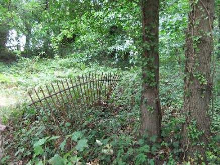
Denis Minett on banking

                                                                © via Brooklands Museum

                                                         Looking south down the Finishing
                                                      Straight, from the Members’ Banking

                                                         Radley House Partnership - 2013

                                                      Members’ Banking, looking west from
                                                                    Members’ Hill Bridge

                                                         Radley House Partnership - 2013

                                                       Railway Straight, looking north-east

                                                         Radley House Partnership - 2013

Brooklands Heritage Partnership   CONSULTATION COPY                Radley House Partnership
Gazetteer: June 2017                                                        A1 - Page 5 of 7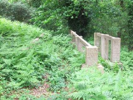
View, looking northeast, along the
                                                      western section of the Byfleet Banking

                                                          Radley House Partnership - 2013

                                                              View, looking north, along the
                                                                    southwestern section of
                                                                        the Byfleet Banking

                                                          Radley House Partnership - 2013

                                                             View, looking southeast, along
                                                                     southern section of the
                                                                            Byfleet Banking

                                                          Radley House Partnership - 2013

                                                          View, looking northeast, along the
                                                                       southeastern section
                                                                      of the Byfleet Banking

                                                          Radley House Partnership - 2013

Brooklands Heritage Partnership   CONSULTATION COPY                 Radley House Partnership
Gazetteer: June 2017                                                         A1 - Page 6 of 7
View, looking northeast, across
the Cobham Bridge,
spanning the River Wey
Radley House Partnership - 2013
Revisions
Date Comments
Brooklands Heritage Partnership CONSULTATION COPY Radley House Partnership
Gazetteer: June 2017 A1 - Page 7 of 7BROOKLANDS AERODROME & MOTOR RACING CIRCUIT
HERITAGE ASSETS GAZETTEER
Members’ Hill – inc. Test Hill, Air-Raid Shelters
Reference Status Scheduled Monument
& Bofors Anti-Aircraft Gun Tower
Summary Location
Designation SM33961 - 01
Reference: Historic England
Date: 1907 (first motor racing association)
Association: Motor Racing & Military
Function: Natural topographical feature, developed for use
as part of the racing circuit and now part of the
Museum site.
Scheduled: 17 January 1975
Amended: 7 January 2002
History and Description
This natural topographic feature, which once formed part of ancient woodland, became isolated through
the construction of the race track when it was initially sandwiched between the Members’ Banking and
Finishing Straight (before the Campbell Circuit was added along its southern edge in 1937). Its location
and formation provided a prime vantage point for spectators and the site for the Members’ Restaurant
and main grandstands during the motor racing period – as a result, from its opening in 1907, it was
divided into four areas along its southern side by a series of railings (some of which still remain today).
From the west these included: (i) the ‘Members’ Enclosure’, which contained their own grandstand and
had access to the Restaurant; (ii) the ‘Reserved Lawn’, which contained the ‘Tattersalls’ grandstand and
again had access to the Restaurant; (iii) the ‘Five Shilling Enclosure’, which contained two grandstands;
and (iv) at the eastern end was the ‘Public Enclosure’ which was just a grassed area. Members’ were
provided with their own access above the track via ‘Members’ Bridge’ a steel framed structure, supplied
by Head Wrightson & Co. Ltd. of Thornaby-on-Tees (the current bridge is a 1988 replica), whereas the
other spectators used the series of three parallel tunnels under the track, on the northeast side of the hill.
In 1909 the Test Hill was added, which brought more focus to the hill. It consisted of a concrete roadway,
352ft (107.3m) in length across varying gradients (average 1:5), constructed to allow automobile
engineers to test engine acceleration and vehicle braking. In 1937, when the Campbell Circuit was built a
footbridge was built over this road racing circuit to allow spectators to move between the hill and the other
spectator and car parking areas to the south, which was located between The Fork and the Finishing
Straight.
Following the outbreak of World War Two, the lightweight structures (grandstands and Campbell Bridge
etc.) were removed and the Hill became a defensive point for the airfield with a 40mm ‘Bofors’ Anti-
Aircraft Gun and Sighting Tower added on the north side of the Restaurant building along with a series of
other wartime structures, including a series of pre-cast concrete frames and bases on the south side of
the Hill, which are understood to have been the footings and supporting framework for a timber ‘mess’
type building where the personnel crewing the gun tower would have been based; and a number of air
raid shelters built against and into the bottom of the hill on both the west and northeast sides. These
shelters were associated with the Wellington production line hangars built across the track. Three brick
and concrete shelters were built into the bottom of the bank on the northeast side, each containing a
series of rooms/cells with blast walls externally. Whereas on the west side, the shelter was constructed
by excavating the foot of the hill, casting a reinforced concrete tunnel which was then buried in earth with
both entrances protected externally by brick blast walls at each end.
Brooklands Heritage Partnership CONSULTATION COPY Radley House Partnership
Gazetteer: June 2017 A2- Page 1 of 6During the 1970s and 1980s the Brooklands Society (founded in 1967) carried out the arduous task of
clearing away much of the post-war industrial features and materials that obscured much of the historic
features on and around Members’ Hill, so that it could once again be appreciated and understood by the
public. Further clearance work by Brooklands Museum staff and volunteers also helped to uncover other
war-time and post-war features on the south side of the banking. The Museum has also recently replaced
the railings up the side of the Test Hill road surface, using early photographs to replicate the original
design.
Significance/Value
Although predominantly a natural topographic feature, the landscaping carried out during the construction
of the track and the subsequent above and below ground built features added to it, give Members’ Hill
significant value in the context of Brooklands. This both in terms of its connections with the motor racing
history (i.e. extant Members’ Hill Restaurant buildings and Test Hill) and to its aviation history (with the
remains of the World War Two features). This national importance is recognised through its inclusion as
a distinct element of the Brooklands Scheduled Monument.
Risks and Recommendations
Located within the Museum site, the area benefits to a degree from the on-site understanding and
knowledge associated with the site. However, as many of these remains have now become obscured by
vegetation, there is a risk that they can be easily overlooked by visitors due to their lack of context and
understanding. This includes the surviving sections of old metal railings which would once have divided
up the Hill into its different spectator enclosures and the concrete bases/footings from former bridges
which originally allowed spectators access over the Campbell Circuit to the south and also allowed
spectators to move down the side of the Test Hill and across it at the same time.
Furthermore, with no hard-surfacing alongside the Test Hill surface itself, the grass becomes badly worn
as a result of visitor footfall, exposing the earth and tree roots etc. which in turn leads to further erosion
damage with routes being worn into the surface.
Relevant CMP Recommendations: G2-G7, C1-C11, M1, M3-6 and EC1
Sources
Brooklands Museum Archives
Brooklands Museum Website & Guidebook
Brooklands Motoring History Timeline – Julian Temple, Brooklands Museum (15/12/2013)
The Finishing Straight (F/S) Timeline – Julian Temple, Brooklands Museum (13/12/13)
Members’ Hill Grandstands Timeline – Julian Temple, Brooklands Museum (16/12/13)
Historic England Scheduled Monument Description
Illustrations
Cars going to start of Horsley Plate
Race (1907) with members banking in
background
© via Brooklands Museum
Brooklands Heritage Partnership CONSULTATION COPY Radley House Partnership
Gazetteer: June 2017 A2- Page 2 of 6Crowds on Members’ Hill (1907)
© via Brooklands Museum
Test Hill on Opening Day,
25 March 1909
© via Brooklands Museum
Saloon cars descending Test Hill
(1929)
© via Brooklands Museum
Aerial view of Members’ Hill
pre-1937
© via Brooklands Museum
Brooklands Heritage Partnership CONSULTATION COPY Radley House Partnership
Gazetteer: June 2017 A2- Page 3 of 6Test Hill out of use and relocated
World War 2 hut visible in top of
picture, located on reinforced concrete
foundations originally built for one of
the grandstand s
Post-war date unknown
© via Brooklands Museum
Looking up Test Hill
Radley House Partnership - 2013
Air raid shelters, northeast side of
Members’ Hill, built in late 1940s for
Vickers dispersal hangar T222
Radley House Partnership - 2013
Brooklands Heritage Partnership CONSULTATION COPY Radley House Partnership
Gazetteer: June 2017 A2- Page 4 of 6Air raid shelter interior, west side
of Members’ Hill
Radley House Partnership - 2013
‘Bofors’ Anti-Aircraft Gun Tower
Radley House Partnership - 2013
World War 2 hut, relocated here post-
war on top of extant reinforced
concrete foundations, originally built for
a grandstand on south side of
Members’ Hill
Radley House Partnership - 2013
Brooklands Heritage Partnership CONSULTATION COPY Radley House Partnership
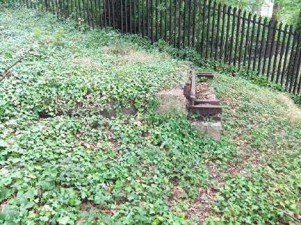
Gazetteer: June 2017 A2- Page 5 of 6Remains of iron railings from former
spectator enclosures/pathways
across Members’ Hill
Radley House Partnership - 2013
Remains of concrete footings and iron
framing from former pedestrian bridge
(timber) spanning the
Campbell Circuit
Radley House Partnership - 2013
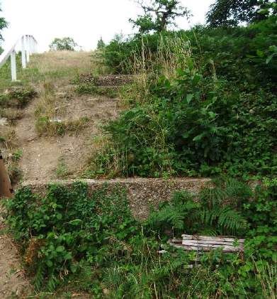
View of concrete footings (2 no.) from
former pedestrian bridge alongside
Test Hill, originally spanning
transverse path across Members’ Hill
Radley House Partnership - 2013
Revisions
Date Comments
Brooklands Heritage Partnership CONSULTATION COPY Radley House Partnership
Gazetteer: June 2017 A2- Page 6 of 6BROOKLANDS AERODROME & MOTOR RACING CIRCUIT
HERITAGE ASSETS GAZETTEER
Reference Aerodrome Road Status Scheduled Monument
Summary Location
Designation SM33961 – 08 & 10
Reference: Historic England
Date: 1911/12
Association: Aviation
Function: Originally provided a means of access between
the Motoring Village to the north of Brooklands
and the Flying Village to the southwest. The
extant sections are now used by pedestrians to
move around the site (where accessible)
Scheduled: 17 January 1975
Amended: 7 January 2002
History and Description
Aerodrome Road was constructed with ‘macadam’ laid over the top of natural clay or compacted
hardcore, without any form of kerb or edging, as a service road between the southwest corner of the
Paddock in the Motoring Village and the east side of the Flying Village, located inside the southwest
corner of the Byfleet Banking. Originally timber bridges were constructed over the oxbow lake and
bent?/bend in the River Wey. With the back-filling of the oxbow lake, only the southern bridge was
required and still remains, which in 1931 was replaced by Surrey County Council with a ferro-concrete
bridge – at the same time the road was completely repaired and re-tarred.
The road operated as a perimeter road for the aerodrome with part-built or dismantled aeroplanes moved
around the site (especially by Hawker Aircraft Ltd. in the 1930s), however it is not believed to have ever
been used as a taxiway for aircraft. The north end of the road also gave spectators access to car parking
which was located, on race days, between the river and the Finishing Straight.
By the early 1950s, with the growth of Vickers-Armstrongs works, the southern section of Aerodrome
Road was improved and widened to allow two-way vehicular traffic, so that it could be used by
emergency vehicles and other site traffic to move easily within the perimeter of the site.
Following the closure of the British Aerospace factory by 1989 and the subsequent redevelopment of
areas of Brooklands in the 1990s, sections of the road were removed. Most notably at its northern end,
adjacent to the Campbell Bridge, where a 280m (918’) length of road was removed as part of flood
protection measures associated with The Heights development in the early 2000s. More recently, in
2013, further building work was carried out to extend one of the office buildings up to the edge of
Aerodrome Road just near to the Museum boundary.
Significance/Value
As the only means of circulation between the Motoring Village and the Flying Village, for vehicles and
aircraft components, what now remains of the road is of considerable national significance and value to
the Brooklands Conservation Area as one of only a few surviving early remains of the aerodrome. This
national importance is recognised through its inclusion as a distinct element of the Brooklands Scheduled
Monument.
Brooklands Heritage Partnership CONSULTATION COPY Radley House Partnership
Gazetteer: June 2017 A3 - Page 1 of 3Risks and Recommendations
The isolated locations of the extant sections of Aerodrome Road put them to a higher degree of risk
through a potential lack of public understanding as to their value, relevance and importance to Brooklands
aviation history.
The impact of visitor footfall across its surface is minimal, compared to its original use by vehicles.
However, encroaching vegetation along its edges and surface (The Heights) puts the remaining sections
at significant risk of loss. This risk has been further compounded for the sections contained within The
Heights, where trees have been planted near to its eastern edge – as they mature and their root system
develops, they may begin to cause damage and lead to loss of the track edge and alignment.
Relevant CMP Recommendations: G2-G7, C1-C11, M1, M3-6 and EC2-3
Sources
Brooklands Museum Archives
‘Aerodrome Road’ at Brooklands, Surrey Timeline – Julian Temple, Brooklands Museum (13/12/2013)
Historic England Scheduled Monument Description
Illustrations
Oblique view of Brooklands from the
north in 1926, with Aerodrome Road
visible along the east side of the
riverbank – between the Motoring
Village and Byfleet Banking in the
distance.
© via Brooklands Museum
Oblique view of the BAe East Works in
the 1980s with Aerodrome Road
clearly visible along the east riverbank
and across the bridge over
River Wey to the south
© via Brooklands Museum
Brooklands Heritage Partnership CONSULTATION COPY Radley House Partnership
Gazetteer: June 2017 A3 - Page 2 of 3Extant section of Aerodrome Road,
within ‘The Heights’ development,
becoming obscured by
grass and vegetation.
Radley House Partnership - 2013
Extant section of Aerodrome Road,
within the Brooklands Community park,
inside the Byfleet Banking.
Radley House Partnership - 2013
Revisions
Date Comments
Brooklands Heritage Partnership CONSULTATION COPY Radley House Partnership
Gazetteer: June 2017 A3 - Page 3 of 3BROOKLANDS AERODROME & MOTOR RACING CIRCUIT
HERITAGE ASSETS GAZETTEER
Brooklands Motor Racing Circuit –
Reference Status Scheduled Monument
Campbell Circuit
Summary Location
Designation SM33961 – 01 & 02
Reference: Historic England
Date: 1937
Association: Motor Racing
Function: Originally a road racing circuit, now the eastern
section is used as access to Brooklands
Museum and the western section forms part of
the Mercedes-Benz World test track.
Scheduled: 17 January 1975
Amended: 7 January 2002
History and Description
Sir Malcolm Campbell designed this road circuit in 1936, in response to the declining popularity of
Brooklands as a motor racing venue; construction began in the same year – as with the Outer Circuit, it
was constructed in a series of regular concrete bays. Unlike the original Outer Circuit, the Campbell
Circuit was constructed with reinforced concrete, the total length of this circuit measured approximately
2¼ miles (4.4 kilometres) and was typically 32 feet (9.75 metres) wide, increasing to 40 feet (12.2 metres)
at the corners. Completed in 1937 and officially opened by Dame Ethel Locke King on 20th April, it linked
the Members’ Banking and Railway Straight of the Outer Circuit with a series of straights and bends laid
out across the north end of the aerodrome and the south side of Members’ Hill. The circuit was used for
motor car and motorcycle racing, as well as a ‘Soap Box Derby’ in July 1939 – a month before its last
race use before the outbreak of the war. During World War Two, the Campbell Circuit was camouflaged
and the Campbell Bridge was a vital link between the Vickers factory and the aerodrome – narrowly
escaping destruction when the Luftwaffe bombed Vickers on 4th September 1940. On the western
section, a hangar was built beside the Campbell Circuit for use by Communications aircraft and these and
Vickers aircraft were towed along the road for dispersed parking. Anti-aircraft defences were also hastily
built adjacent to the Campbell Circuit in 1940/41. Post-war, the Campbell Circuit had relatively little use
except by factory site transport vehicles particularly using the former Campbell Bridge which led to a new
tarmac and concrete link road across the centre of the aerodrome linking the much expanded
Vickers/BAC/Bae East and West Works. The northeast section became the main access route for the
new Brooklands Museum from c.1989 but has been used only as a staff and delivery entrance since
Mercedes-Benz World provided a new public entrance and car park in late 2006.
Sections of the track adjoining the Railway Straight were lost in 1951, following the construction of the
concrete runway and taxiway by Vickers-Armstrongs which ran north-south through Brooklands, while
eastern sections largely survived within the Vickers/BAC/Bae factory until 1989/90 when they were lost
through demolition and the redevelopment of the former British Aerospace East Works for The Heights
Business Park. The majority of the Campbell Circuit Pits also survived in use as stores until demolished
just hours before the Brooklands Conservation Area was designated in November 1989. Five sections of
Campbell’s original circuit however do survive, these are Test Hill Hairpin and Dunlop’s Delight (both
located on the Brooklands Museum site), the Banking Bend (located in the JTI UK site) and the Sahara
Straight and Howe’s Corner including the Campbell Bridge over the River Wey (in the Mercedes-Benz
World site). The Campbell Bridge was originally built c.1927 to enable Vickers aircraft to be taken over
the River Wey between the factory and aerodrome and was then modified in 1937 to accommodate the
Brooklands Heritage Partnership CONSULTATION COPY Radley House Partnership
Gazetteer: June 2017 A4 - Page 1 of 6Campbell Circuit too. As well as the track itself, many of the original associated features and details still survive alongside the sections within the Museum site. These include: sections of the in-situ cast concrete retaining walls around the north side of the Test Hill Hairpin and northeast side of Dunlop’s Delight – the latter having three openings with steps, beyond which was originally provided access to the spectator enclosures on Members’ Hill; sections of low-level in-situ cast concrete kerbing (including metal columns and formwork encased within) along the southwestern edge of the track surface; and the remains of a pre-cast drainage gully at the southern end of Dunlop’s Delight and the inner radius of the Banking Bend. Significance/Value Although this circuit had a relatively short period of intended use, compared to that of the Outer Circuit, it has considerable cultural and historic significance due to its connection with Sir Malcolm Campbell as well as it being the last stage of motor racing circuit development ever carried out at Brooklands, before the track’s closure in 1939 due to the outbreak of war. Making it both nationally and internationally important – hence its inclusion as part of the Brooklands Scheduled Monument. Risks and Recommendations The principal challenge in the conservation of the Campbell Circuit is the vulnerability of degrading surfaces, and the need to retain originality and patina of age – a key aspect of which is related to ongoing maintenance through weed/vegetation control and management. Significant damage to certain sections in recent decades has been caused by winter flooding and erosion of subsoil causing sections to subside. In addition, further damage is caused by heavy goods vehicles, buses and cranes which travel across these sections of track – all of which should be ideally discouraged from driving over the Scheduled Monument. Unauthorised works to the Scheduled Monument are an issue, with respect to the Campbell Circuit this relates to the Campbell Bridge where the east side of the structure which would have connected with the river bank was been removed (c. 2010) and is yet to be reinstated and properly repaired. Every effort should be made to address the reasons that lead to its removal and so allow the missing section to be properly reinstated. Historic England is currently in discussion with the relevant landowners about repairing this bridge and its abutments. All of the surviving sections of the Campbell Circuit are still used by vehicles, either as means of access/parking (JTI UK Ltd and Museum) or for driving courses (Mercedes-Benz World). Consequently, the surface is degrading to varying degrees – with sections of the Sahara Straight and Dunlops’ Delight having already been resurfaced with tarmac (pre-1980s and early 21st century respectively) and complete bays of the track have been replaced with new concrete (Sahara Straight). The risks of incremental concrete maintenance repairs, which have potential to diminish the asset being conserved, may only apply if not properly managed through the use of matching concrete mix designs and very skilful application. Whilst the preferred objective is to leave the surfaces ‘as found’, there may be a necessity for repair or making good (e.g. for safety reasons – with respect to this, Historic England has generally approved of tarmac being used for temporary essential repairs). In addition, the restrictions on public access to some of the sections add a degree of risk through a potential lack of public understanding as to their value, relevance and importance to Brooklands motor racing history. The low-lying elements, Sahara Straight and Howe’s Corner, also remain at risk from prolonged flooding, during extreme flood conditions. Relevant CMP Recommendations: G2-G7, C1-C11, M1 and M3-6 Sources Brooklands Museum Archives The Campbell Road Circuit (1937) Timeline – Julian Temple, Brooklands Museum (20/06/2013) Historic England Scheduled Monument Description Brooklands Heritage Partnership CONSULTATION COPY Radley House Partnership Gazetteer: June 2017 A4 - Page 2 of 6
Illustrations

                                                        Campbell Circuit being constructed
                                                       alongside the Outer Circuit Finishing
                                                                      Straight (circa 1936)

                                                                 © via Brooklands Museum

                                                        Construction of the south end of the
                                                      Campbell Circuit Finishing Straight as
                                                       it crosses the Outer Circuit Finishing
                                                                           Straight (c. 1936)

                                                                 © via Brooklands Museum

                                                       Construction of the Campbell Circuit
                                                               showing the c.1927 Vickers
                                                      constructed bridge that was modified
                                                          to accommodate the new circuit
                                                                                    (1936)

                                                                 © via Brooklands Museum

Brooklands Heritage Partnership   CONSULTATION COPY                 Radley House Partnership
Gazetteer: June 2017                                                         A4 - Page 3 of 6
Looking north along the Finishing
Straight, with the Test Hill Hairpin,
Dunlop’s Delight and the Banking
Bend all visible in front of Members’
Hill (date unknown)
© via Brooklands Museum
View from the Banking Bend along
Dunlop’s Delight to the south of
Members’ Hill at a BARC Meeting in
August 1939
© via Brooklands Museum
Wellington L4212 being pushed over
the Campbell Bridge
(date unknown)w
© Vickers-Armstrongs Ltd via
Brooklands Museum
Test Hill Hairpin, looking southwest,
with concrete retaining wall
alongside Members’ Hill
Radley House Partnership - 2013
Brooklands Heritage Partnership CONSULTATION COPY Radley House Partnership
Gazetteer: June 2017 A4 - Page 4 of 6Low-level in-situ cast concrete
kerbing to the southwestern
edge of Dunlop’s Delight
Radley House Partnership - 2013
The remains of the ‘Banking Bend’
which would have led round to the
Members’ Banking on the Outer
Circuit. Now used as car parking by
JTI UK staff
Radley House Partnership - 2013
View of the Sahara Straight,
looking north
Radley House Partnership - 2013
Brooklands Heritage Partnership CONSULTATION COPY Radley House Partnership
Gazetteer: June 2017 A4 - Page 5 of 6The Campbell Bridge, spanning across
the River Wey (viewed from
the southwest)
Radley House Partnership - 2013
Revisions
Date Comments
Brooklands Heritage Partnership CONSULTATION COPY Radley House Partnership
Gazetteer: June 2017 A4 - Page 6 of 6BROOKLANDS AERODROME & MOTOR RACING CIRCUIT
HERITAGE ASSETS GAZETTEER
Brooklands Motor Racing Circuit –
Reference Status Scheduled Monument
Campbell Circuit Pits
Summary Location
Designation SM33961 - 09
Reference: Historic England
Date: 1937
Association: Motor Racing
Function: Originally the pits garages associated with the
Campbell Circuit, now used for storage purposes
by The Heights grounds maintenance team.
Scheduled: 7 January 2002
(an amendment of the original 1975 scheduling)
History and Description
In conjunction with the creation of the Campbell Circuit in 1937 (see separate Gazetteer entry), the
Campbell Circuit Pits were constructed parallel to the circuit’s new Finishing Straight (which no longer
survives). Built with in-situ cast concrete panels and a painted rendered finish externally, they were
divided into a series of open-fronted garage bays with a concrete flat roof over.
During the second half of the twentieth century, under Vickers-Armstrongs ownership, the structure was
given the reference ‘T68’ & ‘T241’ where it was identified as ‘Track Pits’ and ‘Store’ respectively having
been adapted for storage use with rendered concrete blockwork used to infill former openings and
construct a central spine wall. The full length of the Pits survived until November 1989, when all but the
surviving 3½ bays were demolished, just hours before the Brooklands Conservation Area was
designated.
Following the redevelopment of the area now known as The Heights, the external ground levels have
been raised, while rendered concrete blockwork has been used to infill former openings and construct a
central spine wall to create a single storage space which runs the full length of the building. Externally,
plaques identifying the names of former drivers and course personnel have been added above the former
‘pit frontage’, along with a series of painted murals stylistically depicting 1930s motor racing.
Significance/Value
Although its context is now lost and the intended operation of the Campbell Circuit and the Pits was
relatively short compared to other motor racing assets at Brooklands, the surviving remains of this
structure still have considerable cultural and historic significance due to their connection with Sir Malcolm
Campbell as well as being the surviving feature from the last stages of motor racing at Brooklands,
before the Circuit’s closure in 1939 due to the outbreak of war. This structure is therefore both nationally
and internationally important – hence included as part of the Brooklands Scheduled Monument.
Brooklands Heritage Partnership CONSULTATION COPY Radley House Partnership
Gazetteer: June 2017 A5 - Page 1 of 3Risks and Recommendations
The surviving Campbell Pits now stand isolated within The Heights development, alongside the principal
vehicle access route into the site. Through loss of context, in combination with the inferred restrictions on
general public access around The Heights a degree of risk as a consequence of a potential lack of public
understanding as to the value, relevance and importance of the former Pits with the later stages of
Brooklands’ motor racing history – such confusion over the Pits’ historic value already exists due to the
use of later blockwork added during the Vickers-Armstrongs alteration works.
The current private use of the building reduces the risk of damage through general wear and tear and
visitor footfall – as may occur with other built heritage assets within Brooklands. However, the leadwork
copings to the end parapet walls are at risk from theft (evidence of attempted theft was noted during an
August 2013 site appraisal). Should this occur, the core of the historic structure will also be put at risk
from water penetration.
Relevant CMP Recommendations: G2-G5, C1-C11, M1 and M3-5
Sources
Brooklands Museum Archives
The Campbell Road Circuit (1937) Timeline – Julian Temple, Brooklands Museum (20/06/2013)
Historic England Scheduled Monument Description
Illustrations
Start of the JCC ‘200’ in front of the
Campbell Circuit Pits in 1938
© via Brooklands Museum
Campbell Circuit Pits during a
Sports Car Race in July 1939
© via Brooklands Museum
Brooklands Heritage Partnership CONSULTATION COPY Radley House Partnership
Gazetteer: June 2017 A5 - Page 2 of 3The remains of the Campbell Circuit
Pits, viewed from the south-east
Radley House Partnership - 2013
The remains of the
Campbell Circuit Pits,
viewed from the south-west
Radley House Partnership - 2013
Raised floor levels evident along
with remains of former pit divisions
and enclosures. ‘Modern’ in-fill
wall (left hand side) decorated with
motor racing mural.
Radley House Partnership - 2013
Revisions
Date Comments
Brooklands Heritage Partnership CONSULTATION COPY Radley House Partnership
Gazetteer: June 2017 A5 - Page 3 of 3BROOKLANDS AERODROME & MOTOR RACING CIRCUIT HERITAGE ASSETS GAZETTEER Reference ‘Vickers’ Bridge Status Scheduled Monument Summary Location Designation SM33961 - 03 Reference: Historic England Date: Late 1940 Association: Aviation & Military Function: Access bridge over the River Wey Scheduled: 17 January 1975 Amended: 7 January 2002 History and Description The bridge was built by Vickers-Armstrongs around late 1940, to enable their newly manufactured Wellington bombers (and subsequently other aircraft) to cross the River Wey and access the airfield from the Bellman hangar located on the Finishing Straight. They could then disperse to other airfields around the country, or be tested and prepared for collection. Constructed from panels of cast-iron riveted together, a concrete surface and kerbing is laid across its top to form the roadway. The exact date of the bridge’s construction is unknown, although most likely to be late 1940 when the related Bellman hangar was also completed. Photographic evidence suggests another ‘Bailey’ type bridge was originally built in this location circa 1937, to provide a secondary means of vehicular and pedestrian access to the sections of the Campbell Circuit on the west side of the River Wey. This is not to be confused with the earlier Campbell Bridge (located further south) which was Vickers’ primary access to the pre-war and war-time aerodrome from c.1927. This current bridge has only been named the ‘Vickers’ Bridge by Brooklands Museum staff from the early 21st century. The bridge now functions as a secondary means of vehicular access into the Museum site as well as allowing the transfer of historic aircraft to the grass runway beyond during aviation events. Significance/Value As a vital means of circulation around the site, for aircraft following their manufacture and preparation for dispersal, the bridge is of considerable national significance and value to the Brooklands Conservation Area as one of only a few surviving remains from its operation as a wartime aerodrome – and later post- war aircraft manufacture. This national importance is recognised through its inclusion as a distinct element of the Brooklands Scheduled Monument. Risks and Recommendations Readily accessible from Brooklands Drive (west side of River Wey) there is a risk of damage and increased wear to the concrete track surface from additional vehicle movements – including HGVs and buses which use the bridge as a turning point – this risk could be reduced with appropriate (discreet) signage and regular monitoring. Any repairs to the concrete surface should be carried out through liaison with Historic England to ensure the appropriate materials and methods of workmanship are applied. Brooklands Heritage Partnership CONSULTATION COPY Radley House Partnership Gazetteer: June 2017 A6 - Page 1 of 3
It’s somewhat isolated position across the River Wey, between the main complex of museum buildings
and the service entry points to Mercedes-Benz World, puts the structure to a degree of risk through a
potential lack of public understanding as to its value, relevance and importance to Brooklands.

Relevant CMP Recommendations: G2-G5, C1-C11, M1 and M3-5

Sources

CORLEY, DENIS & HUTCHINS, TONY: ‘Brooklands Aerodrome – The Years 1939 to 2006’
     Airfield Review
     April 2006
Historic England Scheduled Monument Description

Illustrations

                                                                   The ‘Vickers’ Bridge allowing aircraft to
                                                                    cross the River Wey and access the
                                                                      airfield from the Bellman hangar
                                                                    located on the Finishing Straight –
                                                                    photo taken in 1947 at the ‘launch’
                                                                          of the Stratosphere Chamber

                                                                                © via Brooklands Museum

                                                                   A ‘Bailey’ bridge seen in the location of
                                                                          the current Vickers bridge – date
                                                                              unknown (circa Spring 1937)

                                                                                © via Brooklands Museum

                                                                       View, of the Vickers Bridge looking
                                                                           south east from the west bank
                                                                                         of the River Wey

                                                                        Radley House Partnership - 2013

Brooklands Heritage Partnership            CONSULTATION COPY                       Radley House Partnership
Gazetteer: June 2017                                                                        A6 - Page 2 of 3
Looking across the bridge towards the
Museum, the original concrete surface
and kerbing remains although
degrading in some areas
Radley House Partnership - 2013
Revisions
Date Comments
Brooklands Heritage Partnership CONSULTATION COPY Radley House Partnership
Gazetteer: June 2017 A6 - Page 3 of 3BROOKLANDS AERODROME & MOTOR RACING CIRCUIT
HERITAGE ASSETS GAZETTEER
Reference Brooklands Memorial Status Scheduled Monument
Summary Location
Designation SM33961 – 04
Reference: Historic England
Date: 1957
Association: Motor Racing and Aviation
Function: Memorial
Scheduled: 17 January 1975
(an amendment of the original 1975 scheduling)
History and Description
Designed by architects Ley Colbeck & Partners, following a commission by Vickers-Armstrongs (Aircraft)
Ltd., the memorial was faced with blocks of ‘white spar cast stone’ over a masonry core. Measuring 9.5m
(31’) long, 1.5m (5’) wide and 4.2m (14’) high, the Memorial was originally located on the north western
side of the former airfield facing the London to Portsmouth railway line.
It was built to commemorate the 50th anniversary of the site and included the text ‘Brooklands 1907-1939’
in 2’ (0.6m) high bronze letters on both sides, as well as a large bronze plaque containing a sculptured
plan view of Brooklands and a panel of text, on its north western face. It is understood to have been built
by local contractors with the bronze details cast by a subsidiary of Vickers.
The Memorial text on the plaque reads as follows:
“On this site in 1907, H F Locke-King, Esq., built the Brooklands Motor Racing Circuit - the
first of its kind in the world.
Brooklands, from 1907 to 1939, was the scene of many famous car and motorcycle races
and three world's land speed records were established on the circuit. Numerous other
records of endurance and speed were also made at Brooklands by all classes of motor
cars and motorcycles.
The 340 acre area enclosed by the track was used as one of England's earliest
aerodromes and many of the great pioneers built and flew their aircraft here. The first
flying experiments at the track were those of A V Roe in 1907-8 and subsequently many of
the leading British aircraft companies were based at Brooklands.
Much aviation history was made from this place. The Vickers Vimy aircraft in which Alcock
and Brown made the first non-stop Atlantic flight in 1919 was built and tested here.
Brooklands was used for military and test flying from 1914 to 1918, and from then until
1939 it became the world's most renowned centre of motor racing and of sporting flying.
During the second world war aircraft built or assembled at Brooklands took part in every
major campaign.
Brooklands Heritage Partnership CONSULTATION COPY Radley House Partnership
Gazetteer: June 2017 A7 - Page 1 of 5In 1946 the motor racing track and aerodrome were taken over by Vickers-Armstrongs,
Limited and were devoted exclusively to the advancement of civil and military aviation.
This memorial was erected by Vickers-Armstrongs (Aircraft) Limited and was unveiled on
July 6th 1957, by Lord Brabazon of Tara, P.C., G.B.E., M.C., in the presence of many of
those who on the track or in the air had helped to create the fame and tradition of
Brooklands.”
Some of the dignitaries present at the unveiling included: Sir Alliot Verdon-Roe, Earl Howe, The Duke of
Richmond and Gordon, Major-General C A L Dunphie (Chairman of Vickers-Armstrongs (Aircraft) Ltd.),
Capt. Duncan Davis and George Edwards.
During the 1980s the large letters were replaced in plywood following the earlier theft of the original
bronze plaque and letters, before being replaced again in plastic in the 1990s. The only original bronze
element to survive is the sculptured plan view of Brooklands, which is now housed in the entrance foyer
to the BARC Clubhouse.
In 2003 the Memorial was carefully dismantled and relocated to its current location in the Museum site
with the same orientation as the original, following the redevelopment of the north western area of the
former airfield by Mercedes-Benz with their principal building ‘Mercedes-Benz World’ being built over the
site of the Memorial.
Significance/Value
Although the Memorial is no longer in its original location and only has modern replicas of the original
bronze detailing, it is still of considerable significance and value to Brooklands in terms of both the
motoring and aviation histories – through its design, content and its connection with those responsible for
the original commission. It has therefore been included as part of the Brooklands Scheduled Monument.
Risks and Recommendations
Having been relocated to the edge of the Museum site, the Memorial now benefits from the on-site
understanding and knowledge associated with Brooklands history. However, its somewhat isolated
location and loss of context from its original site put the structure to a degree of risk through a potential
lack of public understanding. Riverside tree growth and vegetation partially obscures the northwest
elevation from outside of the Museum site and the reconstituted stone is beginning to become stained
and fracture at the arrises, possibly as a result of water penetration and subsequent frost damage – this
will further reduce its visual impact and interest to the public, especially if seen from the west side of the
River Wey. Specialist input would be required to monitor and assess this damage so that appropriate and
sympathetic repairs can be specified.
Relevant CMP Recommendations: G2-G5, C1-C11, M1 and M3-5
Sources
The Brooklands Memorial (1957) Timeline – Julian Temple, Brooklands Museum (16/12/2013)
Historic England Scheduled Monument Description
Brooklands Heritage Partnership CONSULTATION COPY Radley House Partnership
Gazetteer: June 2017 A7 - Page 2 of 5You can also read