CALIFORNIA DEPARTMENT OF FISH AND WILDLIFE CENTRAL REGION'S WILDLIFE AREA MEETING 08/17/2021 - CA.gov
←
→
Page content transcription
If your browser does not render page correctly, please read the page content below
CALIFORNIA DEPARTMENT OF FISH AND
WILDLIFE CENTRAL REGION’S WILDLIFE AREA
               MEETING
              08/17/2021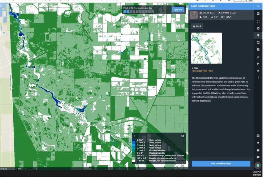
FISH AND GAME CODE

•   FISH AND GAME CODE
•   DIVISION 2. DEPARTMENT OF FISH AND GAME [700 - 1940]
•   CHAPTER 7.5. Native Species Conservation and Enhancement [1750 - 1772]
•   ARTICLE 2.5. Bird Habitat Conservation [1758- 1758.]

•   1758.
•   The department shall annually provide an opportunity for licensed hunters to comment and
    make recommendations on the public hunting programs, including anticipated habitat conditions
    in the hunting areas on Type A and Type B Wildlife Areas, as defined under the commission’s
    regulations, through public meetings or other public outreach. In complying with this section, the
    department may hold regional meetings on its hunting programs for several different wildlife
    areas.
•   (Added by Stats. 2013, Ch. 387, Sec. 2. Effective January 1, 2014.)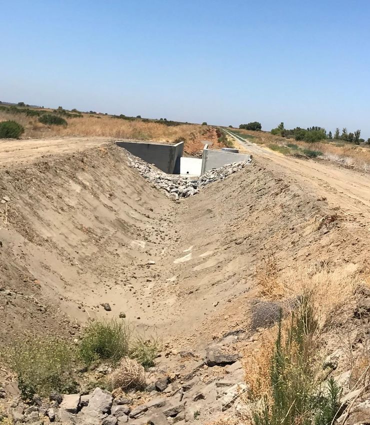
Mendota WA   2021 PUBLIC
             MEETING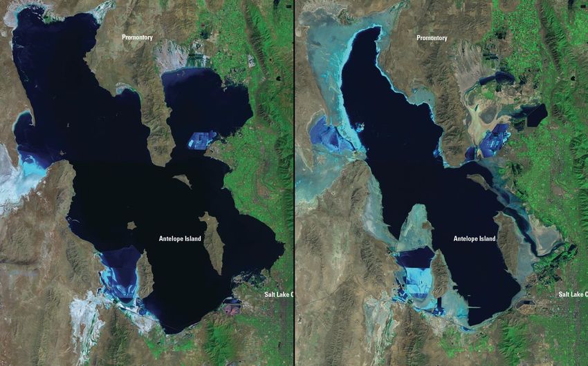
2021-2022
Proposed
Flood-up
Schedule
~70% Water supply leading to more staged or
late flooding.
Why? To save water and provide improved
conditions for waterfowl late into the winter.
Petrie et al 2016. Potential effects of drought
on waterfowl carrying capacity in the Central
Valley
FOLLOWING SLIDES FROM MARK PETRIE REPORT
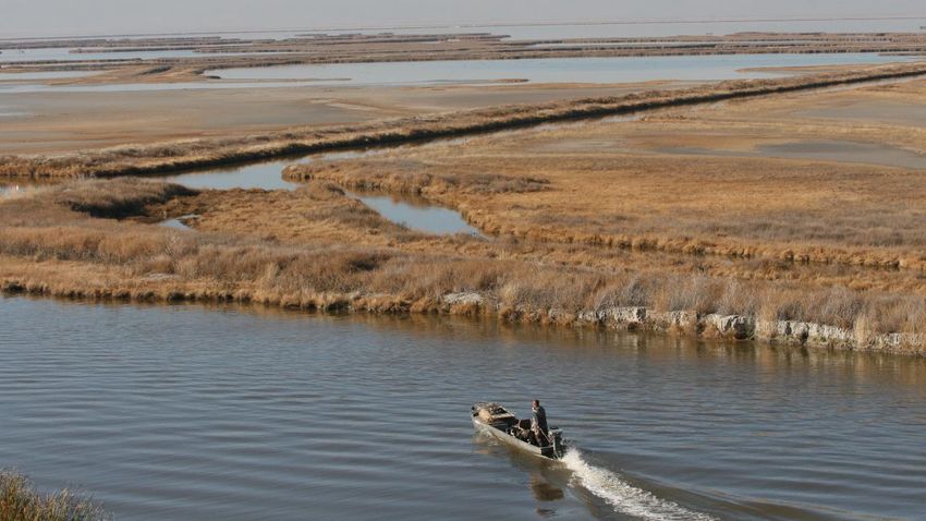
Table 6. TRUEMET model scenarios used to evaluate the potential impacts of drought on carrying capacity for ducks and geese in
the Central Valley of California. All foraging habitats expressed as hectares.
                  Duck             Managed         Planted       Winter-flooded        Unflooded        Deep-plowed          NMW         Harvested
Scenario       populationsa        wetlands          riceb            ricec              riced             ricee             ricef       grain corn

#1             NAWMP                83,721         225,647           142,158              62,619            20,873                0         25,240
#2             80% NAWMP            83,721         225,647           142,158              62,619            20,873                0         25,240
#3             NAWMP                62,791         171,728            20,235             113,620            37,873                0         14,225
#4             80% NAWMP            62,791         171,728            20,235             113,620            37,873                0         14,225
#5             NAWMP                62,791         171,728            30,353             106,031            35,344                0         14,225
#6             80% NAWMP            62,791         171,728            30,353             106,031            35,344                0         14,225
#7             80% NAWMP            62,791         171,728            20,235              75,746            75,746                0         14,225
#8             80% NAWMP            62,791         171,728            30,353              70,688            70,688                0         14,225
#9             80% NAWMP            62,791         171,728            20,235              98,443            32,814           20,235         14,225
#10            80% NAWMP            62,791         171,728            30,353              90,855            30,285           20,235         14,225
a
  NAWMP ¼ North American Waterfowl Management Plan; population objectives for ducks in the Central Valley when continental duck populations
                       als. See Table 2.
b
  Amount of rice planted in the Central Valley that is available for harvest, excluding rice planted in the San Joaquin drainag e basin.
c
  Rice fields that are intentionally flooded after harvest.
d
  Rice fields that are not intentionally flooded or deep plowed after harvest
e Rice fields that are deep plowed after harvest and that are assumed to provide no food resources.
f
  No-maintenance-water rice. Rice fields that are intentionally flooded after harvest but that receive no supplemental water to maintain flooding
  through winter and early spring. These rice fields are assumed to be dry by early December.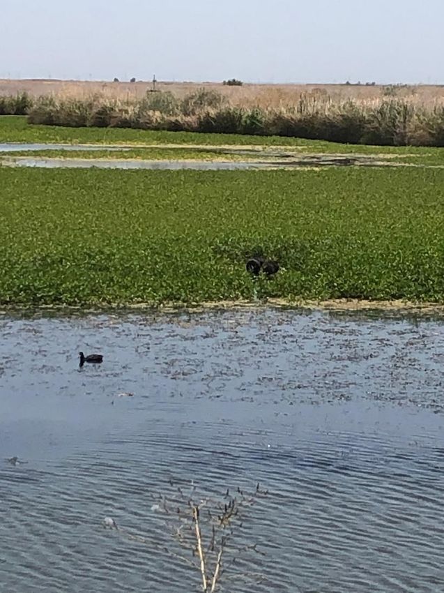
Waterfowl Food, Energy Demand
           vs. Supply
California Drought and Waterfowl           M.J. Petrie et al.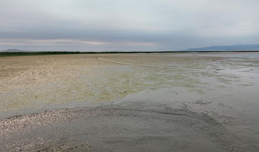
Waterfowl Food, Energy Demand
           vs. Supply

Figure 3. Food energy demand (solid line) vs. food energy supply (dashed lines) for ducks in the Central Valley when duck
populations are at 80% of North American Waterfowl Management Plan goals, and under habitat conditions described for Scenarios
2, 4, 6, 7, 8, 9, and 10 (Table 6).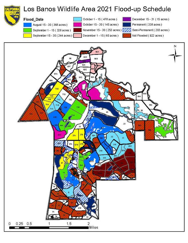
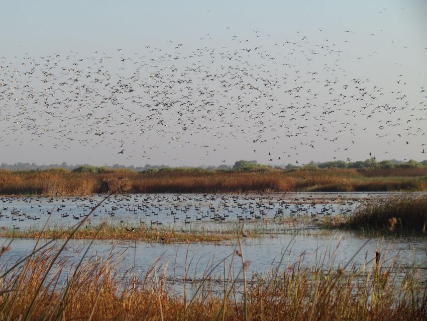
2021 Drought impacts will include drastic
changes to Salt Lake, Northern
California, and Sacramento Valley
Flooded Rice

Scenarios not accounted for in 2016 modeling
Lower Lake Levels
  will mean far
 fewer wetlands

Normal Year
Unmanaged Wetlands:
325,000 acres
Managed wetlands:
160,000

2021
Unmanaged Wetlands:
Most/all dry
Managed wetlands:
110,000
1986                 2021

2,300 Square Miles   950 Square Miles
Lower Klamath Refuge
                          Normal: 25,000 acres of wetlands
                           Today: 600 acres of wetlands

 Tule Lake Refuge
Normal: 15,000 acres of
      wetlands
 Today: 2,000 acres of
      wetlands
Winter-Flooded Rice: Normal Year vs 2021
Drought
Hunting Season
400000
350000
300000
250000
Acres 200000
150000
100000
50000
0
Normal 2021 DroughtAbove satellite imagery shows areas within the Fresno Slough/Mendota Pool in white (other than Tule Island) are predominately water hyacinth with a mix of additional aquatic plants.
Hyacinth has completely
impacted the ability to launch
boats from north of the MWA
bridge. Currently, discussions are
taking place on whether trailer
mounted boats will be allowed to
launch at Lots 4 &5.
Safflower planted in
typical areas. Received
less irrigation but did
make seed.
Additional info from 2021
public hunt meeting can
be found by visiting the
Los Banos WA page
GENERAL COMMENTS
Water supply is 60% to 70% of a normal year for State wildlife areas in the San Joaquin
Valley. These numbers reflect the 75% allocation of our Level 2 supply along with the
loss of a good portion of Level 4 water that would usually be made available
Appropriative water pumping rights were curtailed. We used our riparian rights for
summer irrigations instead so far. State Water Board may curtail Riparian rights in the
next few days.
Deep wells were used for some summer irrigations and will also be used to augment
some surface supplies for fall flood-up. This may allow the State to reallocate surface
supply to other areas. (Deep wells cannot generate enough water to fully flood and
maintain wetlands by themselves and water quality can also be an issue)
Last winter a combined 5,000 acre-feet of water from all State wildlife areas was
conserved from our 2020-21 water allotment. By anticipating the need to carry this water
over and pulling down ponds we knew needed rehabilitation, we were able to conserve
water to carry over to water year 2021-22. This water was vital to being able to do spring
irrigations.
DFW is working with other agencies and NGOs to ensure wetland habitat and water
supplies are distributed across the flyway to best benefit waterfowl and other birds.
A lack of foraging habitat for early migrating waterfowl and the depletion of late season
forage may be two significant effects of the current drought. Significant by products of
those conditions may lead to waterfowl disease: Avian Botulism (late summer) and Fowl
Cholera (mid winter).LOS BANOS
WILDLIFE AREA COMPLEX
Sean Allen
Manager, LBWAC
Los Banos Wildlife Area
Mud Slough Unit
Volta Wildlife Area
Little Panoche Reservoir Wildlife Area
Cottonwood Creek Wildlife Area
San Luis Reservoir Wildlife Area
O’Neill Forebay Wildlife AreaLOS BANOS WA HIGHLIGHTS
AND CHALLENGES 2021/2022
• We would like to thank all our hunters for your diligence last year during
the Covid-19 pandemic. You were very understanding and adaptable
during the season and we appreciated your patience! I would also like to
thank our staff for their willingness to run these areas at some risk to their
health and that of their families. We are fortunate to have people so
dedicated to public service.
• We have begun the process of trying to allow limited deer hunting on the
areas. Opportunities will likely be by special drawing through the WA and
occur after September 15 until the close of A Zone General season which
would be September 26 this year.
• 85 acres of safflower was planted, and mowing has begun for dove
season. A 100-hunter limited reservation hunt with a fill-in lottery draw
the night before will occur, similar to previous opening days.
• We will be planting another 200 pheasants for the Wednesday before
Thanksgiving, November 24th and for Saturday after November 27th
(100 for each day)LOS BANOS WA HUNTER QUOTAS
2021/2022
QUOTAS ARE OUR BEST ESTIMATE AND SUBJECT TO CHANGE
Date Acres 2021-22 2020-21
Flooded Hunter Quota Hunter Quota
Opening Day
1563 65 70
November 1
1816 65 70
December 1
1891 90 100
January 1
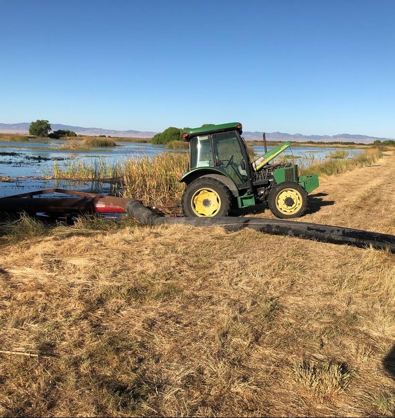
1910 120 120WATER CONSERVATION MEASURES
PUMPING IRRIGATION WATER
FROM 72B TO 73BWATER CONSERVATION MEASURES
PUMPING IRRIGATION WATER
FROM 17C TO 19AVOLTA WA HIGHLIGHTS AND
CHALLENGES 2021/2022
• Wetland acreage should be 85% of a normal year and flooded similar to the
previous year.
• Most of the thirties and teens were spot disced and mowed. Most of the other
ponds on the eastside were spot disced and mowed as needed.
• Field 10 was dry again, this time primarily due to the drought. In July we were
able to disc Field 10 east of the wasteway further to the north than in the past
few years. Last summer’s large amount of discing promoted a great deal of
moist soil growth in Field 10.
• Water was started in late last week on the east side and fall flooding will
continue throughout the next few months.
• Two new repogle flumes were installed this year to measure water lifted from
the wasteway into the east and west ditches. Be careful when heading out to
parking lot 4, the corner is wider than before.VOLTA WA HUNTER QUOTAS
2021/2022
QUOTAS ARE OUR BEST ESTIMATE AND SUBJECT TO CHANGE
Date Acres Flooded 2020-21 Hunter 2019-20 Hunter
Quota Quota
Opening Day
1691 90 100
November 1
1931 100 115
December 1
1931 115 125
January 1
2000 135 135REPOGLE FLUME WESTSIDE DITCH ON THE WAY TO LOT 4
REPOGLE FLUME
   EASTSIDE DITCH
BEHIND CHECK STATION
MUD SLOUGH UNIT
 LOS BANOS WA HIGHLIGHTS AND
    CHALLENGES 2021/2022
• Units 3B, 4B, 5A&B received spring irrigations.
• Some spot discing and mowing occurred in all
  fields.
• Area will not be available on opening day.
  Scheduled to open last Saturday in November
• The area should be completely flooded by early
  December and all blinds should be available.
NORTH GRASSLANDS
WILDLIFE AREA COMPLEX
Pat Cotta
Assistant Manager for
Steven Miyamoto
Manager, NGWAC
Salt Slough Unit
Gadwall Unit
China Island UnitSALT SLOUGH UNIT
NORTH GRASSLANDS WA
HIGHLIGHTS AND CHALLENGES
2021/2022
• Staff irrigated 550 acres of watergrass and 100 acres of swamp timothy.
• Waterfowl hunter quota for opening weekend is expected to be 40 hunters.
• Zone 13 - Blinds will be closed for the season due to the pond’s poor water retention and the
drought. If hydrology changes mid season, Zone 13 may be flooded on a limited basis.
• Staff re-seeded watergrass in ponds 27 and 28. These ponds may be difficult to wade in due
to the heavy disking.
• Most of our summer irrigations and brood water was lifted from Salt Slough utilizing our
Riparian Water rights and conserving our Level 2 surface water supply for fall and winter
flooding.
• 35 acres of safflower and 65 acres of winter wheat was planted and irrigated to maturity. Staff
is completing mowing.
• CWA came to the Grasslands and trapped and banded this summer (see next slide).CWA BANDING TOTALS Location Name Mallards Total Ducks Lone Tree 8 9 P 26 Los Banos WA 60 60 Westervelt South 25 29 Redwood 5 6 Salt Slough 14 27 32 Volta 39 15 18 Triangle 22 24 Gilroy 9 10 Sprig Haven Farms 0 1 TOTAL 171 189
SALT SLOUGH UNIT
          NORTH GRASSLANDS WA
          HUNTER QUOTAS 2021-22
  QUOTAS ARE OUR BEST ESTIMATE AND SUBJECT TO CHANGE

   Date       Acres Flooded   2021-22 Hunter   2020-21 Hunter
                                  Quota            Quota

Opening Day
                  678         40 + ADA Blind        40

November 1
                  858         40 + ADA Blind        40

December 1
                  858         50 + ADA Blind        55

 January 1
                  858         50 + ADA Blind        55
SALT SLOUGH FIELD 47
WATERGRASSSALT SLOUGH FIELD 41
WATERGRASSSALT SLOUGH FIELD 33 REHABILITATION
CHINA ISLAND UNIT
        NORTH GRASSLANDS WA
     HIGHLIGHTS AND CHALLENGES
              2021/2022
• 210 acres of watergrass and 130 acres of swamp timothy were irrigated.
• Waterfowl opening weekend hunter quota is expected to be 10 on the
  flood plain only. Managed wetlands will not be huntable until November.
  Quota will increase as more wetlands are flooded. Maximum quota will be
  up to 40 hunters.
• 35 acres of safflower was planted and irrigated to maturity. 25 acres of
  volunteer wheat was irrigated to maturity resulting in good seed
  production. An additional 40 acres of newly planted wheat was irrigated
  to maturity resulting in good seed production.
• Ponds 8 and 24, totaling 110 acres, were seeded to watergrass and
  irrigated.
• There continues to be issues with rank aquatic vegetation growing in the
  cement delivery canal. This allows for sediment build-up and reduces
  capacity of the canal. An excavator was leased last fall and a week was
  spent removing all the silt and submerge aquatic vegetation. This will
  likely be an annual job.
CHINA ISLAND UNIT
NORTH GRASSLANDS WA
HUNTER QUOTAS 2021/2022
QUOTAS ARE OUR BEST ESTIMATE AND SUBJECT TO CHANGE
Date Acres Flooded 2021-22 Hunter 2020-21 Hunter
Quota Quota
Opening Day Mud Slough
San Joaquin River 10 10
November 1
225 20 10
December 1
370 30 30
January 1
561 40 40CHINA ISLAND F8 RESEEDED WATERGRASS
CHINA ISLAND F24
RESEEDED WATERGRASS
GADWALL UNIT
          NORTH GRASSLANDS WA
       HIGHLIGHTS AND CHALLENGES
               2021/2022
• An existing 1000 feet of concrete delivery ditch was replaced with a 42”
  Sanitite HP pipeline. This project will be a tremendous water conservation
  measure.
• 280 acres of swamp timothy was irrigated in the hunt area.

• Due to the drought fall flooding will begin about September 1st. Due to
  losses experienced during delivery of our water in the Gadwall Canal it is
  best to flood along with other surrounding wetlands to conserve water
  supply for all.
• Opening day quota will be limited to 26 for the free roam area.
• In addition to last year’s blinds, a new standup style blind was installed in
  field 5 along the east edge of the pond. An additional (now 2) ADA blind
  was also installed in field 3 with access from Parking lot D.

• Gadwall Zone F will not open until December 1st.
GADWALL UNIT
NORTH GRASSLANDS WA
HUNTER QUOTAS 2021/2022
QUOTAS ARE OUR BEST ESTIMATE AND SUBJECT TO CHANGE
Date Acres Flooded 2021-22 Hunter 2020-21 Hunter
In Hunt Area Quota Quota
Opening Day
283 26 + 2 ADA Blinds 27
November 1
501 26 + 2 ADA Blinds 27
December 1
882 30 + 2 ADA Blinds 28
January 1
882 30 + 2 ADA Blinds 35BE OUR EYES
WHILE YOU ARE IN THE FIELD
▪ Report any dead or sick waterfowl in a group of 5 or more. Call our
office LBWA (209) 826-0463; Mendota (559) 655-4645 or report
your observations to check station staff as soon as possible.
▪ If you believe you have encountered a Nutria, please call the Nutria
Hotline (866) 440-9530 or email: invasives@wildlife.ca.govTHANKS • To the US Fish and Wildlife San Luis Complex for participating • Special thanks to Grassland Water District for their tireless efforts in securing water supplies for and advocating for the wetlands of the Central Valley and specifically the Grasslands Ecological Area. • To you, our Public for participating in this online information exchange
NORTHERN SAN JOAQUIN VALLEY WILDLIFE AREAS
              PUBLIC MEETING
       AUGUST 17, 2021 4:00-6:00 PM
         QUESTIONS AND ANSWERS
Sean, I'm not sure if I'm going to make the meeting or not. However, I'm concerned that we don't have a remake of last year at Mendota, where we couldn't launch boats from the established ramp due to the water hyacinth. Hopefully something has been done about this. I realize that we might have a bigger problem this year with lack of water. But, just was hoping that we could get the ramp up and running this year. Some of us 'older' guys have purchased boats for this purpose. Don't seem to be able to do the 'Mendota mud' like I did forty years ago. lol! Thanks for considering my question. Have a great week! ed Hi Ed, We have made no progress in hyacinth control in the slough. The attached sat image shows the hyacinth and other aquatic weeds in the slough indicated as white area (other than Tule Island). You can see that there is little to no open water on either the south or north sides of the island. Currently we are discussing whether or not we should allow trailer mounted boats to launch from the unimproved ramps at Lots 4 and 5 due to the concern of boats picking up the hyacinth between the boat and trailer when they load, and transporting it to other water bodies. This image was from 8/4/21. If young hyacinth pops off the bottom en-mass in early October, as occurred last year, the amount of hyacinth coverage is likely to increase by ~25%. Will let you know when a decision is made. Thanks sjb
You can also read