Candidates for landing sites for the Hayabusa2 mission - August 23, 2018 JAXA Hayabusa2 Project
←
→
Page content transcription
If your browser does not render page correctly, please read the page content below
Candidates for landing sites
 for the Hayabusa2 mission;;


        August 23, 2018

     JAXA Hayabusa2 Project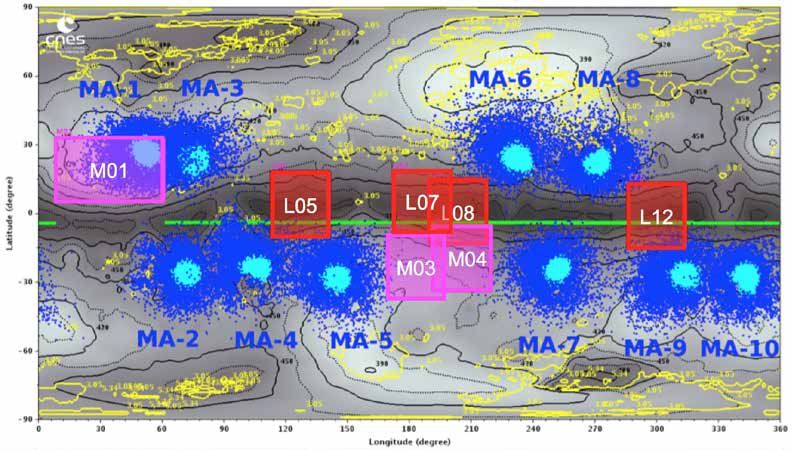
Topics

Regarding Hayabusa2:
    HCandidates for landing sites for touchdown, MASCOT,
     and MINERVA-II

Contents

0. Hayabusa2 & mission flow outline
1. Project status & overall schedule
2. Landing site candidates and expected dates
3. Selection of touchdown site candidates
4. Science discussions for touchdown site candidates
5. Selection of landing site candidates for MASCOT
6. Selection of landing site candidates for MINERVA-II
7. Strategy toward the successful touchdown
8. Future plans
Overview of Hayabusa2
Objective
We will explore and sample the C-type asteroid Ryugu, which is a more primitive
type than the S-type asteroid Itokawa that Hayabusa explored, and elucidate
interactions between minerals, water, and organic matter in the primitive solar
system. By doing so, we will learn about the origin and evolution of Earth, the
oceans, and life, and maintain and develop the technologies for deep-space return
exploration (as demonstrated with Hayabusa), a field in which Japan leads the
world.

Expected results and effects
HBy exploring a C-type asteroid, which is rich in water and organic materials, we
  will clarify interactions between the building blocks of Earth and the evolution of
  its oceans and life, thereby developing solar system science.
H Japan will further its worldwide lead in this field by taking on the new challenge of
  obtaining samples from a crater produced by an impacting device.
HWe will establish stable technologies for return exploration of solar-system bodies.

Features:
HWorld’s first sample return mission to a C-type asteroid.
HWorld’s first attempt at a rendezvous with an asteroid and performance of                                               (Illustration: Akihiro Ikeshita)
 observation before and after projectile impact from an impactor.
HComparison with results from Hayabusa will allow deeper understanding of the
 distribution, origins, and evolution of materials in the solar system.                   Hayabusa 2 primary specifications
                                                                                          Mass               Approx. 609 kg
                                                                                          Launch             3 Dec 2014
                                                                                          Mission            Asteroid return
International positioningL                                                                Arrival            27 June 2018
HJapan is a leader in the field of primitive body exploration, and visiting a type-C      Earth return       2020
  asteroid marks a new accomplishment.                                                    Stay at asteroid   Approx. 18 months
HThis mission builds on the originality and successes of the Hayabusa mission. In         Target body        Near-Earth asteroid Ryugu
  addition to developing planetary science and solar system exploration
  technologies in Japan, this mission develops new frontiers in exploration of            Primary instruments
  primitive heavenly bodies.                                                              Sampling mechanism, re-entry capsule, optical cameras, laser range-finder,
HNASA too is conducting an asteroid sample return mission, OSIRIS-REx (launch:            scientific observation equipment (near-infrared, thermal infrared), impactor,
  2016; asteroid arrival: 2018; Earth return: 2023). We will exchange samples and         miniature rovers.
  otherwise promote scientific exchange, and expect further scientific findings
  through comparison and investigation of the results from both missions.
Mission flow
                                                          Arrival at asteroid
 Launch                                                   une 27, 2018
3 Dec 2014                           B▲
                                     Earth swing-by
                                     3 Dec 2015

                                       Examine the asteroid by remote sensing
                                       observations. Next, release a small lander and
                                       rover and also obtain samples from the surface.

 Earth return                         Depart asteroid
 late 2020                            Nov–Dec 2019

                                                                        Create artificial
                                                                        crater                       Release
                                                                                                     impactor
                                         After confirming safety, touchdown           Use an impactor to create
         Sample analysis                 within the crater and obtain                 an artificial crater on the
                                         subsurface samples                           asteroid’s surface

(Illustrations: Akihiro Ikeshita)
1. Current project status
& schedule overview
Current statusL
– On August 5, we began operations for gravity measurement, approaching
Ryugu to an altitude minimum of 851m at around 08:10 JST on August 7.
The spacecraft then returned to the home position on August 10.
– Based on the data obtained to date, we investigated possible landing points.
– BOX-B operations began on August 18 (scheduled to return to BOX-A on
September 7).
Schedule overview:
2015 2016 2017 2018 2019 2020
12 3 10 12 4 6 7
&2231&(,
12 !* *0512
3:
0-5-&.
$
1630*:51&45*31-) &35,3*5630
Event
48-0+ ': 45*31-)2319-/-5:12*3&5-104
12*3&5-10
launch
Earth swing-by
Arrival at Ryugu
Departure from Ryugu
Capsule re-entry
*( *(
60* 17N*(
&5*
"I
%
J
5*4512*3&5-104 Southern hemisphere station
&: operations (CAN/MLG)
Optical navigation
Solar conjunction
(5
&:
&:
6. 17*(
&3
60
&3
&: 17 23
&0
60 # ## #
Ion engine operations ※
Points to note in this document
            Pay attention to the orientation of the asteroid!

   Public images so far have shown       In this document, like a typical map, north is
   the northern direction of the Solar   drawn pointing upwards. As Ryugu rotates
   System (direction of the Earth’s      backwards, Ryugu’s “north” is at the bottom of
   North Pole) pointing upwards.        the left-hand figure, but the top in this map (top
                                         and bottom are reversed).
                                         From now on, public images also show the
                                         northern direction of Ryugu pointing upwards.
                                                                                      north pole

                                    Earth
                                    North Pole

                       north pole
I©JAXACU. of Aizu et al.J
                                                                                    I©JAXAJ

  Ryugu has a reverse rotation (retrograde)               Example of a Ryugu “map”
2. Landing site candidates and
expected dates
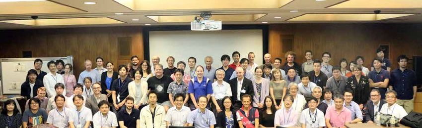
Landing Site SelectionILSS) conference:
BHHeld on August 17, 2018
BH109 attendees (including remote participants)
BH39 participants from overseas (14 from DLR, 2 from CNES and 2 from NASA)
BHDiscussion took place from 10 am to 7 pm.BBBBBB
↓
Determined candidate landing points for spacecraft touchdown, MASCOT & MINERVA-II
I©JAXAJ August 17, 2018: Group photo of LSS meeting 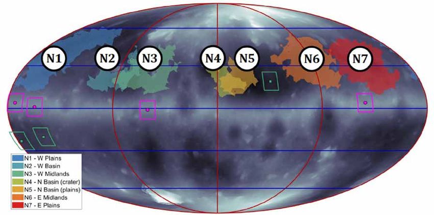
2. Landing site candidates and
expected dates
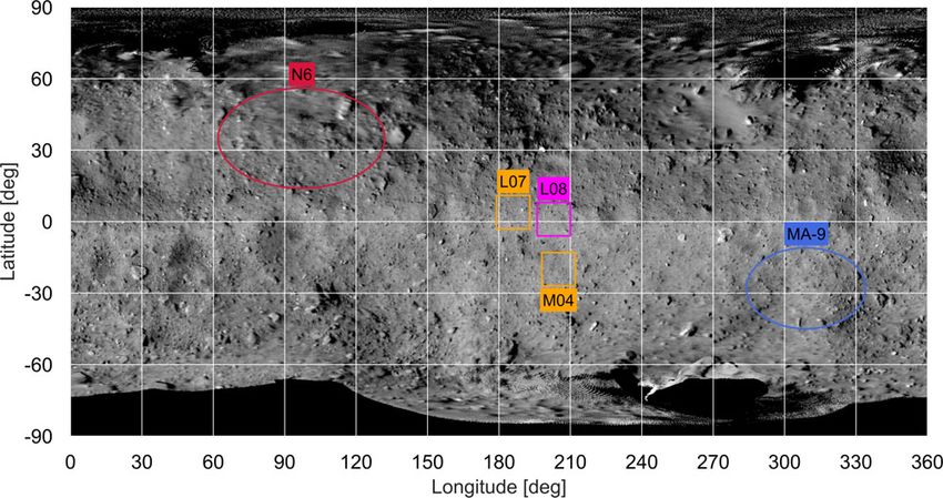
Determined landing site candidates
BBBTouchdown L L08IbackupLL07CM04J
BBBMASCOT L MA-9
BBBMINERVA-II-1 L N6
I©JAXA, University of Tokyo & collaboratorsJ 
2. Landing site candidates and
                         expected dates
       Determined landing site candidates
       BBBTouchdown          LL08IbackupLL07CM04J
       BBBMASCOT             L MA-9
       BBBMINERVA-II-1 L N6

      Touchdown                                MASCOT   MINERVA-II-K

I©JAXA, University of Tokyo & collaboratorsJ
2. Landing site candidates and
                 expected dates
Operation Schedule

BBBTouchdown 1 rehearsal 1:        September 11 ~ 12
BBBBBBBBBIArrival at lowest altitude : September 12J
BBBMINERVA-II-1 operation:     September 20 ~ 21
BBBBBBBBBIMINERVA-II-1 separationLSeptember 21J
BBBMASCOT operation:         October 2 ~ 4
BBBBBBBBBIMASCOT separationLOctober 3J
    Touchdown 1 rehearsal 2:                 mid-October
BBBTouchdown 1:                              late-October

Note: date of operations may be changed.
3. Selection of touchdown site candidates
Prerequisites for touchdown candidate points, part 1
Range on the celestial body where the spacecraft can land
The spacecraft can move along the line connecting the Earth and Ryugu.
BB↓
The region where the spacecraft can land is the area within about 200 m to the north and
south of Ryugu’s equator (range of about ±30° latitude)

                                     Within
  200m
  north
  and
  south
  of

                                     the
  equator
  (about
  ±30° latitude)         Sun

                                                                       Spacecraft
                                                                                          Earth

                                                                 Spacecraft
                                                                 movement
 rotation axis       I©JAXACU. of Aizu et al.)
3. Selection of touchdown site candidates
Prerequisites for touchdown candidate points, part 2
Surface conditions suitable for landing
(1) Average slope within 30°   <   ← Limit due to orientation of solar panels

(2) Flat region with 100m diameter ← Navigation guidance accuracy
(3) Boulder height less than 50cmB← Length of sampler horn
(4) Absolute temperature less than 370KI97=JB
                          ← Within operating temperature range of equipment
              < Mhis angle                                   Sun

                                       Spacecraft
                                                               Earth
             asteroid

                               Spacecraft movement
3. Selection of touchdown site candidates
Procedure of the selection of landing site candidates
B
Step 1:Safety score analyses
Choose safe landing site based on
p Rotation model attitude of probe, surface
p Shape model inclination, terrain conditions etc.
Box-A, Box-C, Mid-alt
Step 2:Visual evaluation
From the images from the Optical
p Optical images Navigation Cameras, investigate
the boulder coverage, presence of
obstacles, surface flatness etc
needed to chose the right place.
Step 3:Feasibility analyses
p Temperature map Confirm temperature and
operation conditions for the time
p Longitude accessibility
of landing. Precisely examine the
Box-A: alt. 20km p Boulder density distribution of boulders.
Box-CLalt. 6km
Medium altitudeL
alt. 5km
3. Selection of touchdown site candidates
Narrow down touchdown candidates: Step 1, from shape model

                                                                      I© U of Aizu, Kobe U., JAXAJ

I©JAXAJ
                                                    Shape model (right) based on data acquired
                                                    during the Medium Altitude Operation, and the
                                                    difference in surface elevation on Ryugu (left)

Safety score for each point is calculated by using the shape model.          The safety score
BItems consideredL
                                                                             value can aid
BBHSun angleIangle between +z axis of S/C and the sun)
BBHSlope angle                                                               selecting a safe
BBHRoughness                                                                location.
3. Selection of touchdown site candidates
Narrow down touchdown candidates: Step 1, from shape model

                                                              100m×100m area.
                                                              I14> x 14> in lat., long.J

                                                       Safety score distribution.
I©JAXAJ
                                                       A smaller value indicated
                                                       higher safety. Gray indicates
                                                       regions above a score of 30.

 Select candidates for landing sites from locations   11 low latitude (“L”) and 4
 with a high degree of safety (low safety value       middle latitudes (“M”) were
 score).                                             selected.
3. Selection of touchdown site candidates
Narrow down touchdown candidates: Step 2, from images
Choose candidate sites from images
                                                  Narrow down to four low
captured with the Optical
                                                  latitude (“L”) and three mid-
Navigation Cameras:
                                                  latitude (“M”) sites.
BFeatures to noteL
BBHBoulder coverage
3. Selection of touchdown site candidates
Narrow down touchdown candidates: Step 2, from images
Candidate sites: four low latitude (“L”) and three mid-latitude (“M”)
I©JAXACU. Tokyo et al.J
3. Selection of touchdown site candidates
Narrow down touchdown candidates: Step 3, feasibility
  Further narrowing down from 7 candidates (4 low latitude, 3 mid-latitude)

Surface temperature:           7 candidate points all OK
absolute temperature
of 370 K or less.

Longitude dependence of surface
approach: communication with
ground tracking stations uninterrupted

         7 candidate points all OK

 Boulder number density:
 less boulders are preferred

    Compare the 7 possible sites                 Surface temperature distribution map
                                                               I©JAXACAshikaga U et al. J
3. Selection of touchdown site candidates
Narrow down touchdown candidates: Step 3, feasibility
Further narrowing down from 7 candidates (4 low latitude, 3 mid-latitude)
Create boulder map and check boulder coverage
I©JAXACU. Tokyo et alJ
Example boulder map 3. Selection of touchdown site candidates
Narrow down touchdown candidates: Step 3, feasibility
Further narrowing down from 7 candidates (4 low latitude, 3 mid-latitude)
Creating boulder maps
L05 L07 L08 L12
M01 M03 M04 Distribution of boulders.
The size of boulders with a
diameter greater than 3m
is indicated by marker size
and color. Brown is for
boulders larger than 10m.
I©JAXAJ
3. Selection of touchdown site candidates
Narrow down touchdown candidates: Step 3, feasibility
 Further narrowing down from 7 candidates (4 low latitude, 3 mid-latitude)
 Determining boulder coverage

           Low latitude
                                Mid- latitude

                                                   At low latitudes, L08, L07 in
                                                   order. At mid-latitudes, M04

                                                            Lower latitudes are
                                                            preferable for ease of
                                                            landing

                                                  Touchdown candidate point is
                                                  L08 (backup: L07, M04)
4. Science discussions for touchdown
site candidates
Features of Ryugu
J Top shape with a very circular equatorial bulge
J Radius: mean 450 mB
BBBBBIequatorial 500 mCpolar 440 mJ
J Mass: 450 million tonIGM30 m3s-2 )<
J Rotation axis: (λ, β) = (180, -87)
J Obliquity: 8°
J Rotation periodLP = 7.63 hours
J Reflectance factor Iv-bandJL0.02
I©JAXACUniversity of
J Crater number density: as much as those on Itokawa and Eros Tokyo & collaboratorsJ
J Many boulders: the largest near the south pole is ~130 m across
J Optical spectra: flat spectra, bluer in equatorial bulge and poles
J NIR spectra: uniform flat (slightly redder) spectra with weak water absorption
J brightness temperatureLstrong roughness effect (flat diurnal Temperature
variation), higher thermal inertia in the equatorial bulge
I4. Science discussions for touchdown
site candidates
Scientific evaluation points of landing site candidates
■ Point 1: surface properties
HExamine surface temperature and thermophysical properties using the Thermal Infrared
Imager data.
HExamine composition differences using spectral data from the Near Infrared Spectrometer.
HExamine terrain, geology and space weathering from different wavelength images from the
Optical Navigation Camera.
BB↓
< Evaluate potential scientific merit.
■ Point 2: safety
HExamine size and spatial distribution of boulders (from images and laser altimeter data). BB
↓
< Evaluate safety by estimating the number of small boulders from the boulder size
distribution.
■ Point 3: sample yield
HEstimate surface grain sizes from observational data from the Thermal Infrared Imager.
BB↓
< From the particle size of surface regolith, evaluate where the maximum amount of sample
can be gathered. 4. Science discussions for touchdown
site candidates
The points for scientific evaluation of the landing site candidates:
one example from observation data.
ONC-T spectral slope map (Box-C)
I©JAXA, University of Tokyo & collaboratorsJ 4. Science discussions for touchdown
site candidates
Summary of the scientific evaluation of landing point candidates
Candidate Point 1 Point 2 Point 3 Total
site surface properties safety Sample yield
L5 22 29 12 63 Although no big
L7 22 31 12 65 difference in
L8 22 31 12 65 evaluation, L08 & L07
L12 22 31 11 64 are good for low
M1 21 33 13 67 latitude (L). M1 & M4
M3 21 30 13 64 are good if mid-latitude
M4 21 33 13 67 (M) is preferred.
Surface temperature, visible / near- Mid-latitudes (M) seem to have many smaller
infrared spectrum etc. There is no sized particles, which is expected to increase the
big differences across the surface, sample yield.
which is almost uniform. However,
there are minor differences. Safety is evaluated from information such as
Spectral characteristics indicate number density of boulders, estimated number of
that lower latitudes may contain smaller boulders and surface roughness.
more diverse particles.
4. Science discussions for touchdown
                     site candidates
Summary of the scientific evaluation of landing point candidates

Scientifically important points:
I1J Difference in mixing ratio of Ryugu surface material has a low
    dependence on location.
I2J A diversity of different materials are present mixed together on
    Ryugu’s surface.
I3J Regardless of where the sample is collected, there is a high
    possibility of gathering diversified materials that represent the
    whole of Ryugu.
5. Selection of landing site candidates
                      for MASCOT
MASCOT (Mobile Asteroid Surface Scout )
J Created by DLR (German Aerospace Center)
  and CNES (French National Centre for Space
  Studies)
J Small lander with mass approx. 10 kg
J Carries four scientific instruments
                                                                                  I©JAXAJ
J Can move only once, by jumping
Scientific instruments aboard MASCOT
Device                      Function

Wide-angle camera           Imaging at multiple wavelengths
(MASCAM)
Spectroscopic microscope    Investigation of mineral
(MicrOmega)                 composition and characteristics
Thermal radiometer (MARA)   Surface temperature measurements

Magnetometer (MASMAG)       Magnetic field measurements
                                                               Flight model (©
  DLR)

  MASCOT
5. Selection of landing site candidates
                     for MASCOT
Criteria for the selection of landing site candidates for MASCOT
 J Probability to land outside the candidates for touchdown > 95 %
 J Probability to have RF link during at least 40% of the asteroid period > 90 %
 J Probability to have a good daylight ratio (between 40% and 70%) > 90 %
 J Selection among remaining candidates to have one candidate per reachable
   and suitable zone, in northern as well as in southern hemisphere
 J No overlap with the landing site candidates for MINERVA-II

computed 10,000  100,000 Monte-Carlo trials
                                    Further conditions
                                    HTemperature (illumination, orientation, heating,
10 candidates                        prior separation, asteroid surface temperature,
                                      night temperature underneath MASCOT)
                                    HOperation
                                    HBoulders
6 candidates & prioritization       HObservation conditions for four instruments
5. Selection of landing site candidates
for MASCOT
Scientific Criteria for Landing Site
Instrument Criteria for Landing Site
MicrOmega Composition of C-rich and/or OH-rich content.
Low Temperature of landing site for high SNR (signal-to-noise ratio).
MASCAM Boulders in the field of view
Fine grained particles
Compositional heterogeneity (color!)
Fresh material (non-weathered)
MARA Thin to no regolith layer.
Landing or hopping close to boulders preferable.
Preferentially less thermally altered region.
MASMAG Low thermal inertia for fine grained fraction of the regolith
Homogeneous thermal inertia (link the MARA + TIR data)
Low rock abundance -> no inhomogeneities in the FoV (field of view)
Remote sensing instruments onboard HY2 give preliminary information on
Ryugu : no big variation over the surface à homogenous
5. Selection of landing site candidates
for MASCOT
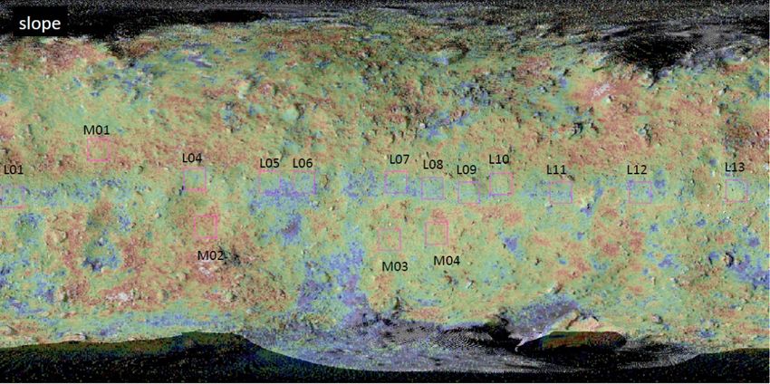
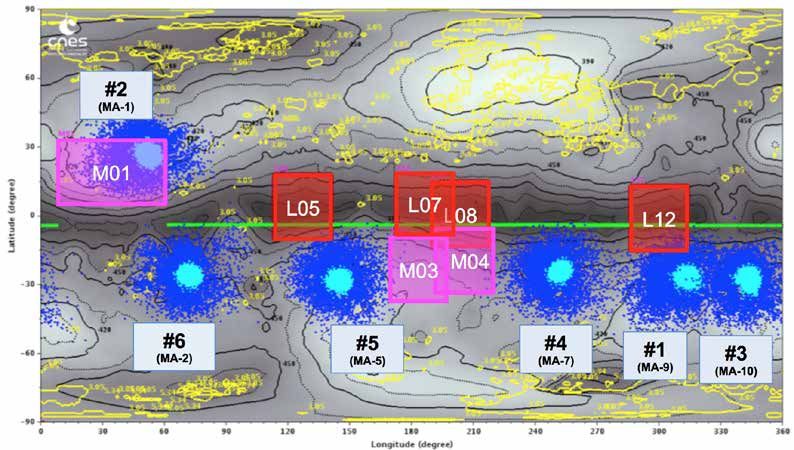
Landing site candidates for MASCOTLL selected 10
candidates (MA-1MA-10)
I©DLR,CNESJ
Light blue shows the first contact points and blue shows the first settlement
points. The candidates of touchdown sites are shown by red squares (low
latitude) and pink squares (mid- latitude). 5. Selection of landing site candidates
for MASCOT
MASCOT Ranking meeting (Toulouse Aug 14)
I© CNES/Rémi Benoît, 2018)
Fruitful meeting, useful rehearsal and training (thanks to JAXA)
=> complex process but all milestones/deliveries were reached
according to the schedule 5. Selection of landing site candidates
for MASCOT
Landing site candidates for MASCOTLLSelection from
10 candidates and the order of priority
I©DLR,CNESJ
Priority of landing siteLMA-9 > MA-1 > MA-10 > MA-7 > MA-5 > MA-2
5. Selection of landing site candidates
                        for MASCOT
                                           MASCOT landing site

©JAXA, University Tokyo, Kochi University, Rikkyo University, Nagoya University,
 Chiba Institute of Technology, Meiji University, University of Aizu, AIST, CNES, DLR
6. Selection of landing site candidates
for MINERVA-II
Release of MINERVA-II-1 A & BIMINERVA-II-2 will be released next yearJ
MINERVA-II-1A, 1B
Produced
at JAXA
MINERVA-II-1ACMINERVA-II-1B
MINERVA-II-2 Specification
HsizeLdiameter 17cmCheight 7cm
Created by the MINERVA-II
consortium (Tohoku HweightLabout Kkg each
University, Tokyo Denki HActuatorL2 DC motors
University, Osaka
University, Yamagata HMounted sensorLcamera, photodiode,
University, Tokyo accelerometerCthermometer, gyro.
University of Science)
HCommunication speedL32kbpsImaxJ
I©JAXAJ 6. Selection of landing site candidates
for MINERVA-II
Conditions for MINERVA-II landing site selectionL
H Landing site does not overlap with spacecraft touchdown candidates.
H Landing site does not overlap with MASCOT landing site candidates.
H The altitude of the spacecraft after separation must not be lower than 30m.
H Ensure communication with ground station.
H Not high temperature region, and fewer parts in shadow
HDue to the equatorial ridge, separation near the equator results in widely spaced
landing points to the north and south.
HSeparating in the southern hemisphere may result
in a spacecraft altitude below 30m. north
Landing
location
south Separation
position
HSeparate in northern hemisphere,
more than 100m north of the equator.
I©JAXAJ When separating near the equator, the
landing position spread north and south. 6. Selection of landing site candidates
for MINERVA-II
Landing site candidates for MINERVA-II: northern hemisphere
Possible overlap No communication
with mid-latitude with ground station
touchdown
Longitude 0°
I©JAXAJ
HTouchdownHconfirm no overlap with
MASCOT's landing site. Candidate locationsL
HAlso consider observability etc. using the N6 > N1 > N7
ONC-T camera. 7. Strategy toward the successful touchdown
Landing
site
candidates
A Initial plan selected
at
this
stage.
DCandidate site search?E DRefine
?E
DLanding
opera�on
?E
Iden�fy
mul�ple
technically
Select
2
-‐
3
sites
by
ranking
Perform
rehearsal
descent
&
landing
landable
areas areas
of
scien�fically
high
value for
high
priority
candidate
sites
DCandidate site search@E
DRefine
@E DLanding
opera�on
@E
HHH
Repeat for each landing
Further
examina�on
of
ANew plan landing
feasibility
necessary
at
this
stage.
DCandidate site searchE DRefineE
DGather informationE DLanding (trial) operationE
Iden�fy
mul�ple
By landing rehearsals & landing Landing attempt. Depending on
Select
1
–
3
sites
with
circumstances, stop half-way and
gear operations, collect low altitude
rela�vely
safe
areas
high
scien�fic
merit
and descent guidance information. use data to analyze landing area.
b
Landing Site Selection Operational
(LSS). Conducted at proficiency
conference. High resolution Landing gear Repeat
while
refining
Depending
on
situa�on,
landing
technique
and
reimplement
from
landing
surface images operational data
improving
this
sequence.
site
selec�on
based
on
opera�onal
knowledge 7. Strategy toward the successful touchdown
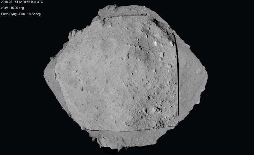
Important point
Detail of surface from low altitude
How far can the
navigation
guidance accuracy
be increased?
I©JAXACGFJ
Ryugu surface taken from an altitude of about 1km.
8. Future Plans
■Schedule for press briefings
J Sept. 5 IWedJ11:00N12:00
J Sept. 27 IThursJ14:30N15:30
■Outreach and events (in Japanese)
Ø Events for Children
J Why Hayabusa2? Any questions classroom
J Sept. 2 (Sunday) 2 – 4pm
J Sagamihara City Museum
J Online broadcast planned
(Time : JST)
You can also read