Northbrook Wanaka Retirement Village - Architectural Design Statement for Resource Consent Version 2, March 2021 - EPA NZ
←
→
Page content transcription
If your browser does not render page correctly, please read the page content below
Northbrook Wanaka Retirement Village
Architectural Design Statement for Resource Consent
Version 2, March 2021
Contents.

Project Overview. ����������������������������������������������������������������������������������������������������� 1
          Introduction. �������������������������������������������������������������������������������������������������������������������������������2
          Visualisation 1. ���������������������������������������������������������������������������������������������������������������������������3
          Visualisation 2. ���������������������������������������������������������������������������������������������������������������������������4
          Visualisation 3. ���������������������������������������������������������������������������������������������������������������������������5
          Visualisation 4. ���������������������������������������������������������������������������������������������������������������������������6

Context. ��������������������������������������������������������������������������������������������������������������������� 7
          Context: location & amenities. �������������������������������������������������������������������������������������������������8
          Context: existing & proposed local amenities. �������������������������������������������������������������������������9
          Context: existing & proposed site access & networks. ���������������������������������������������������������10
          Context: recent nearby development. �����������������������������������������������������������������������������������11
          Context: operative district plan. ���������������������������������������������������������������������������������������������12
          Context: proposed district plan. ���������������������������������������������������������������������������������������������13
          Context: Northlake Special Zone structure plan. �������������������������������������������������������������������14
Site. ���������������������������������������������������������������������������������������������������������������������������15
          Site: aerial views of site. ���������������������������������������������������������������������������������������������������������16
          Site: environmental analysis. �������������������������������������������������������������������������������������������������17
Concept. �������������������������������������������������������������������������������������������������������������������18
          Concept: project opportunities. �����������������������������������������������������������������������������������������������19
          Concept: massing narrative. ���������������������������������������������������������������������������������������������������20
          Concept: project response. �����������������������������������������������������������������������������������������������������21
          Concept: masterplan. �������������������������������������������������������������������������������������������������������������22
          Concept: masterplan. �������������������������������������������������������������������������������������������������������������23
          Concept: building typology plan. �������������������������������������������������������������������������������������������24
          Concept: care home, active recreation centre, & entrance building design narrative. �������25
          Concept: residential apartment unit design narrative. �����������������������������������������������������������26
          Concept: precedent imagery. �������������������������������������������������������������������������������������������������27
          Concept: CPTED. �������������������������������������������������������������������������������������������������������������������28
          Concept: material palette. �������������������������������������������������������������������������������������������������������29

Northbrook Wanaka Retirement Village Resource Consent Design Statement March 2021                                                                           ii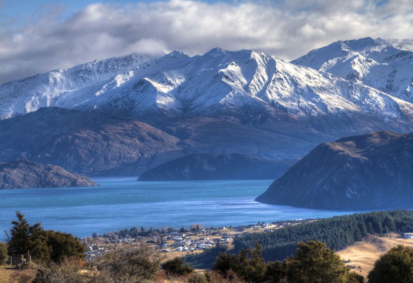
Project Overview.

                    1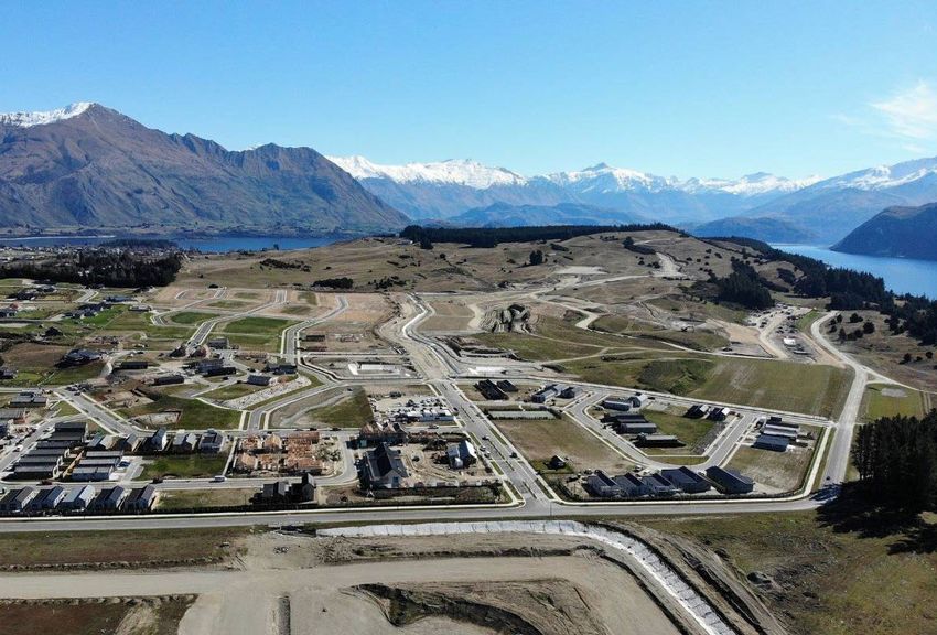
Introduction.

This design statement describes the proposed retirement village and care
facility development at Northlake, Wanaka for Northlake Investments Ltd. A
multidisciplinary team has prepared this application and where necessary
this document refers to other consultants’ documentation. This statement
should be read in conjunction with the architectural & landscape drawings
and other consultant reports.

Legal Description (overall site): Lot 2008, DP 545513
Planning Zone: Northlake Special Zones, Area C2, Area D1, Area E1

The proposal consists of 100 self-contained apartments with supporting
facilities including on site care unit with 36 specialist care units, communal
kitchen and dining, Main Entry Building with offices, staff room, kitchen,
goods delivery area and storage rooms, Amenity & Club House building
which includes a, lounge bar & kitchen, back of house areas, pool, spa, gym,
and yoga room.

                                                                                    Aerial view of Northlake subdivision looking west

                                                                                    The Clutha River to the north of the site.

Northbrook Wanaka Retirement Village Resource Consent Design Statement March 2021                                                       2
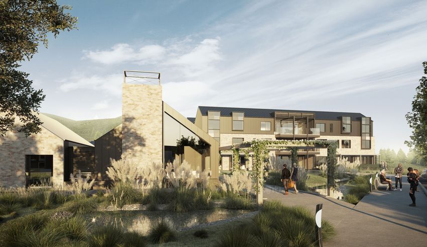
Visualisation 1.

Northbrook Wanaka Retirement Village Resource Consent Design Statement March 2021   3
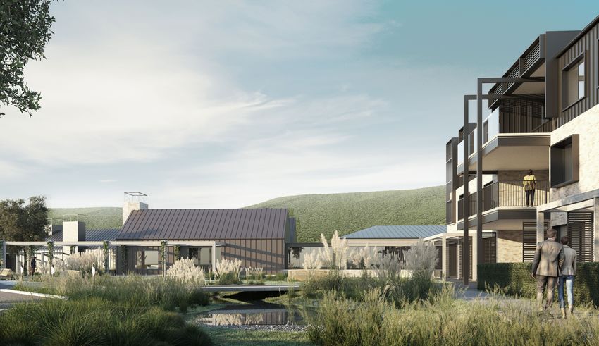
Visualisation 2.

Northbrook Wanaka Retirement Village Resource Consent Design Statement March 2021   4
Visualisation 3.

Northbrook Wanaka Retirement Village Resource Consent Design Statement March 2021   5
Visualisation 4.

Northbrook Wanaka Retirement Village Resource Consent Design Statement March 2021   6
Context.

           7
QLDC Web Map
Context: location & amenities.
To Hawea / West The site is located within the Northlake Special Zone, situated near the
Coast via Haast Pass southern bank of the Clutha River close to the Lake Wanaka outlet, and
between the Wanaka town centre to the south-west, and Albert Town to the
south-east.
Clutha River
Lake Wanaka
To Glendhu Bay / West
Wanaka / Treble Cone
Site
30 minute walk
15 minute cycle / 5 minute drive
To Airport / Cromwell / 1 Northlake hub (cafe)
Queenstown
2 Albert Town hub (store, cafe)
3 Three Parks hub (supermarket, recreation centre)
4 Wanaka township (supermarket, banks, retail, cafes, restaurants.)
To Cardrona / Crown Mount Iron
Range / Queenstown 5
Wanaka aerial imagery showing wider context.
Sourced from the LINZ Data Service and licensed for re-use under the Creative Commons Attribution 4.0 New Zealand licence
O
ovided on thisNorthbrook Wanaka
map is intended Retirement
to be Village Resource
general information Consent
only. While Design effort
considerable Statement March
has been made2021
to ensure that the information provided on this site is accurate, current and otherwise adequate in all respects, 8
District Council does not accept any responsibility for content and shall not be responsible for, and excludes all liability, with relation to any claims whatsoever arising from the use of this site and data held within.
0 2.5 5 km
Map date:
Scale @A3 paper size - 1:36,112 Map produced by Queenstown Lakes District Council's GIS viewer 30/06/2020Context: existing & proposed local amenities.
QLDC Web Map
The site is situated on the northern edge of the Northlake Special Zone, and
is adjacent to proposed walkways / cycleways through the subdivision, as
per the Northlake Special Zone Structure Plan. The Northlake community
and commercial hub, containing Monkey Farm restaurant along with
Pinnacles Early Learning Centre, is located a short distance from the site.
The site is located in close proximity to the Clutha River and associated
cycling and walking tracks. Existing cycle / walkways running beside the
Clutha and Lake Wanaka link the site to Luggate to the south-east, and to
the Wanaka town centre to the west.
To Albert Town / Hawea
Site
Outlet walking / cycling track (DOC)
Deans Bank / Dublin Bay walking / cycling track (DOC)
Walkway / cycleway (as per Northlake Special Zone Structure Plan)
Recreation Reserve
1 Mt Iron
To Wanaka
2 Clutha River
3 Monkey Farm Cafe / Restaurant
4 Pinnacles Early Learning Centre
Sourced from the LINZ Data Service and licensed for re-use under the Creative Commons Attribution 4.0 New Zealand licence
Northbrook Wanaka Retirement Village Resource Consent Design Statement March 2021 9
to be general information only. While considerable effort has been made to ensure that the information provided on this site is accurate, current and otherwise adequate in all respects,
ept any responsibility for content and shall not be responsible for, and excludes all liability, with relation to any claims whatsoever arising from the use of this site and data held within.
0 0.5 1 km
Map date:QLDC Web Map
Context: existing & proposed site access & networks.
The site area is defined by Outlet Road to the north-eastern side and a rising
landform to the south-west which boarders with Activity Area E1. The main
entry is proposed in the centre of the development from Outlet Road with an
exit only pathway running onto Lindis Road. This entry point guides visitors
correctly through the site and means that the development does not become
a vehicular thoroughfare with vehicles entering from Lindis Road. At a small
scale, the development site is close to the integrated walkways / cycleways
that run through the heart of the Structure Plan, allowing further connection
and sense of community.
To Albert Town / Hawea
Site
Outlet walking / cycling track (DOC)
Deans Bank / Dublin Bay walking / cycling track (DOC)
Walkway / cycleway (as per Northlake Special Zone Structure Plan)
Aubrey Road (classified as arterial)
Outlet Road
Northlake Drive
All other local roads with public access
To Wanaka Main access point to Northlake subdivision
1 Mt Iron
2 Clutha River
Sourced from the LINZ Data Service and licensed for re-use under the Creative Commons Attribution 4.0 New Zealand licence
Northbrook Wanaka Retirement Village Resource Consent Design Statement March 2021 10
to be general information only. While considerable effort has been made to ensure that the information provided on this site is accurate, current and otherwise adequate in all respects,
ept any responsibility for content and shall not be responsible for, and excludes all liability, with relation to any claims whatsoever arising from the use of this site and data held within.
0 0.5 1 km
Map date:Context: recent nearby development.
The Northlake development is predominantly residential with the exception
of the local community village hub.
The village hub is characterised by larger scale buildings. Existing buildings
feature simple gable forms and clad in natural and earth-toned materials.
These images capture the commercial and residential character developing
at Northlake.
Monkey Farm cafe / restaurant Proposed Northlake Hotel
Pinnacles Early Learning Centre Proposed Northlake residential development
Pinnacles Early Learning Centre Northlake commercial centre
Northbrook Wanaka Retirement Village Resource Consent Design Statement March 2021 11Context: operative district plan.
QLDC Map
QLDC Map
The site is located within the Northlake Special Zone, within Activity Areas
‘C2’, ‘D1’ and ‘E1’ of the Northlake Structure Plan.
Refer to the Resource Consent Application and Assessment of
Environmental Effects for further information.
QLDC Map
QLDC Map
Site
Northlake Special Zone
Rural Residential Zone
Rural General Zone
Designation (Local Purpose - Recreation)
Low Density Residential Zone
Building Restriction Area
Land Information New Zealand, Eagle Technology
Water body
O
derab le effort ha s been made to e nsu re tha t the in formation provide d o n this site is accu rate , cu rrent a nd oth erwise ade quate in a ll re spe cts.
not b e r esp onsible for, an d e xclude s all liability, with re lation to any clai ms wh atsoever arising from the use o f thi s si te and data held
Landwith in.
Information New Zealand, Eagle Technology
Road
0 0.45 0.9 km
The information provided on this map is in ten ded to be gen eral informati on only. While considerab le effort ha s been made to e nsu re thaMap t the indate:
O
formation provide d o n this site is accu rate , cu rrent a nd oth erwise ade quate in a ll re spe cts.
28 stown L akes District Council does not accept an y responsibility for co nte nt and shall not b e r esp onsible for, an d e xclude s all liability,
Queen 30/06/2020
with re lation to any clai ms wh atsoever arising from the use o f thi s si te and data held with in.
Map produc ed by Queenstown Lakes Distric t Council's G IS viewer
0 0.45 0.9 km Map date:
Scale @A4 paper size - 1:9,028 30/06/2020
Map produc ed by Queenstown Lakes Distric t Council's G IS viewer
Land Information New Zealand, E
The information provided on this map is in ten ded to be gen eral informati on only. While considerab le effort ha s been made to e nsu re tha t the in formation provide d o n thi
Queen stown L akes District Council does not accept an y responsibility for co nte nt and shall not b e r esp onsible for, an d e xclude s all liability, with re lation to any clai ms w
0 0.45
Northbrook Wanaka Retirement Village Resource Consent Design Statement March 2021 Scale @A4 paper size - 1:9,028 12
Map produc ed by Queenstown Lakes Distric t CoContext: proposed district plan.
QLDC Map
QLDC Map
The site is located within the Northlake Special Zone, inside the proposed
Wanaka Urban Growth Boundary.
Refer to the Resource Consent Application and Assessment of
Environmental Effects for further information.
QLDC Map
Site
Northlake Special Zone
Large Lot Residential A
QLDC Map Large Lot Residential B
Lower Density Residential Suburban
Rural Zone
Designation (Nature Conservation)
Moderate - High Landscape Sensitivity Area
Building Restriction Area
Water body
Urban Growth Boundary
Land Information New Zealand, Eagle Technology
Road
O
derab le effort ha s been made to e nsu re tha t the in formation provide d o n this site is accu rate , cu rrent a nd oth erwise ade quate in a ll re spe cts.
Land
not b e r esp onsible for, an d e xclude s all liability, with re lation to any clai ms wh atsoever arising from the use o f thi s si te and data held Information
with in. New Zealand, Eagle Technology ONF Outstanding Natural Feature (Clutha River)
0 0.45 0.9 km
The information provided on this map is in ten ded to be gen eral informati on only. While considerab le effort ha s been made to e nsu re thaMap t the indate:
O
formation provide d o n this site is accu rate , cu rrent a nd oth erwise ade quate in a ll re spe cts.
28 stown L akes District Council does not accept an y responsibility for co nte nt and shall not b e r esp onsible for, an d e xclude s all liability,
Queen with re lation to any clai ms wh atsoever arising from the use o f thi s si te and data held with in.
Outstanding Natural Landscape Boundary
Map produc ed by Queenstown Lakes Distric t Council's G IS viewer
30/06/2020
0 0.45 0.9 km Map date:
Scale @A4 paper size - 1:9,028 30/06/2020
Map produc ed by Queenstown Lakes Distric t Council's G IS viewer
Land Information New Zealand, E
The information provided on this map is in ten ded to be gen eral informati on only. While considerab le effort ha s been made to e nsu re tha t the in formation provide d o n th
Queen stown L akes District Council does not accept an y responsibility for co nte nt and shall not b e r esp onsible for, an d e xclude s all liability, with re lation to any clai ms w
0 0.45
Scale @A4 paper size - 1:9,028
Map produc ed by Queenstown Lakes Distric t Co
Northbrook Wanaka Retirement Village Resource Consent Design Statement March 2021 13NORTHLAKE SPECIAL ZONE - RULES 12
Context: Northlake Special Zone Structure Plan.
Northlake Structure Plan
The site is north-west of the primary development area, and lies within
activity areas ‘C2’,‘D1’ and ‘E1’ of the Northlake Structure Plan.
Refer to the Resource Consent Application and Assessment of
Environmental Effects for further information regarding the ODP and
Structure Plan.
Queenstown-Lakes District Council – DISTRICT PLAN (May 2019)
12 - 385
Site
Northbrook Wanaka Retirement Village Resource Consent Design Statement March 2021 14Site.
15Site: aerial views of site.
Activity Area C1
Activity Area B3
Activity Area E1
Activity Area C2
Activity Area C3
Out
let R
Activity Area D1
oad
Activity Area C2
Aerial view of Northlake subdivision looking north-west. Aerial view of site looking north-west.
The site area is defined by Outlet Road to the north-eastern side and a rising landform to
the south-west which encompasses Activity Area E1 (no-build zone, roading is permitted.)
Site
Activity area boundary
Northbrook Wanaka Retirement Village Resource Consent Design Statement March 2021 16Site: environmental analysis.
The site runs east-west with panoramic views of the Wanaka landscape
including Little Mount Iron & Mount Iron to the south-east, Grandview Range
to the east and Mount Burke to the north.
The prevailing wind is west-north-west off Lake Wanaka. The site is protect-
QLDC Web Map
ed by the existing landform to the west and south-west which will be further
enhanced with native vegetation.
Views to Mt. Burke
The views and solar orientation make this a fitting location for a new retire-
ment village and associated amenities.
Wi
nte
rs nrise
u
ols es
tice
olstic
sun r s
set nte
Wi
Pr
ed
om
ina
nt
we
st
-no
r’w
es
t
Views to Grandview
Sh Range
elt
er
fro
Equinox sunset m Equinox sunrise
lan
df
orm
Su
set mm
sun er
e sol
stic stic
sol es
er un
umm rise
S
Predom
Views to Mt. Roy Views to Little Mt. Iron
inant s
ou’eas
Views to Pisa Range Views to Mt. Iron
t
Site
Northbrook Wanaka Retirement Village Resource Consent Design Statement March 2021 17Concept.
18Concept: project opportunities.
The project presents several opportunities to enhance the visual and social
aspects of the surrounding area.
• Provide positive urban and architectural outcomes.
• Enhance established architectural character.
• Complement local material palette and design vernacular.
• Provide intergenerational interactions within the community.
• Provide views to natural outlook.
• Encourage cycle travel.
Nearby walking / cycle trail, the Clutha River Outlet Track
Established architectural character: Monkey Farm Restaurant
Northbrook Wanaka Retirement Village Resource Consent Design Statement March 2021 19Concept: massing narrative.
The bulk and location layouts illustrate the early studies in building
location and the development of opportunity within the site.
Fig 1.
Positive/
Residential scale fronting streets.
Negative/
Long distance for visitors to the village.
Hard to identify main entry.
Single Entry/Exit point.
Care pod dominant / shading.
Fig 2.
Positive/
Care pod moved to south side of development in a more scale
sensitive location.
Residential scale to street frontage extended.
Negative/
Long distance for visitors to the village.
Hard to identify main entry.
Single Entry/Exit point.
Care pod dominant / shading.
Fig 3.
Positive/
Care pod moved to south side of development in a more scale
sensitive location.
Residential scale to street frontage extended.
Entry point in a central location with exit only at eastern end added
to ease flow.
Secondary road for delivery/staff use.
A. Apartments
C/P. Care Pod
M. Main Entry
A. Amenity / Clubhouse
P. Parking
E. Entry
Northbrook Wanaka Retirement Village Resource Consent Design Statement March 2021 20Concept: project response. In response to the proposed development several key outcomes were deemed desirable. • Quality product on the edge of the Northlake development. • Residential & human scale. • In keeping with the regions’ and overall developments’ vernacular. The project response is based on an unobtrusive and sensitive integration into the developing neighbourhood of Northlake. The majority of the proposal is residential in use and scale becoming an extension of the developing neighbourhood and a continuation of the current language overall development. Building form and material choice are informed by the local vernacular from within Northlake and the surrounding areas of the region with inspiration drawn from rural woolsheds through to the existing buildings within Northlake such as the Childcare Centre. The buildings are located in such a way that the tallest (Care-pod Facility) is located at the rear of the main cluster which diminishes its scale and allows the residential units surrounding it to become the main focus from the periphery. Northbrook Wanaka Retirement Village Resource Consent Design Statement March 2021 21
Concept: high-level masterplan.

1      Village hub
2      Residential apartment units
3      Main entry
4      Exit only

                                        4                                              2          3     1

                                                                                    Outlet Road

                                                                                                      To Clutha River Outlet

    To Northlake Hub /
    Albert Town / Wanaka

Northbrook Wanaka Retirement Village Resource Consent Design Statement March 2021                                              22
Concept: masterplan.
1 Care Pod 5 Reception, offices & lounge 9 Gym / yoga 13 Main entry
2 Emergency vehicle bay 6 Clubhouse / lounge 10 Visitor parking 14 Landscape features
3 BOH & kitchen facilities 7 Pool 11 Staff parking 15 Water feature
4 Delivery bay 8 Plant room 12 Accessway 16 Residential apartment unit
3 4
5 2
6 11
8
7
9
1
Road C
16
16
dB
Roa
14 13
16
14
12 12
16
16
Road A
16 15
10
oad
Outlet R
13 16
Northbrook Wanaka Retirement Village Resource Consent Design Statement March 2021 23Concept: building typology plan.
Main entry / BOH Area Breakdown
Building Name No. of storeys No. of units / No. of beds Total no. of bldgs Total no. of units Total no. of beds Building Total bldg.
Care Pod apartments / apartments coverage (m²) coverage (m²)
Clubhouse / Amenity Block Activity Area C2
Care Pod 3 36 36 1 36 36 892.06 892.06
2 Bedroom Apartment Units Main Entry & BOH 1 - - 1 - - 782.66 782.66
Clubhouse & Amenity 1 - - 1 - - 739.53 739.53
3 Bedroom Apartment Units Apartment Type A 2 3 2 8 32 48 317.26 2538.08
1 3 24
Apartment Type A1 2 3 2 2 8 12 311.79 623.58
1 3 6
Apartment Type B 2 2 2 2 8 8 316.38 632.76
2 3 12
Apartment Type C 2 2 2 5 10 20 163.44 817.2
Apartment Type D 2 1 2 7 14 14 188.78 1321.46
1 3 21
Total (Activity Area C2) 27 108 201 8347.33
Activity Area D1
Apartment Type A 2 3 2 3 12 18 317.26 951.78
1 3 9
Apartment Type B 2 2 2 3 12 12 316.38 949.14
2 3 18
Apartment Type D 2 1 2 2 4 4 188.78 377.56
1 3 6
Total (Activity Area D1) 8 28 67 2278.48
Total (Entire Site) 35 136 268 10625.81
Site Coverage
Area (m²)
Activity Area C2
Total site area 30530.7
Total building coverage 8347.33
Site Coverage % (Activity 27.34
Area C2)
Activity Area D1
Total site area 7562.71
Total building coverage 2278.48
Site Coverage (Activity 30.13
Area D1)
Entire Site
Total site area 38093.41
Total building coverage 10625.81
Total (Entire Site) 27.89
Bed Split
No. of bedrooms per. apt. Total no. of apts.
2 68
3 32
100
Northbrook Wanaka Retirement Village Resource Consent Design Statement March 2021 24Concept: care home, active recreation centre, & entrance building design narrative.
The Care-pod facility has been designed in such a way to reduce its bulk
with the introduction of dormers and balcony spaces which also develop a
consistency in language within the proposed development and Northlake.
Parking for the development is located centrally within the northern end of
the development. This is flanked by densely planted areas and residential
units fronting Outlet Road which aid in concealing them from the perspective
of passers-by.
The Amenity, Clubhouse and Main Entry buildings are single level gable
forms with breaks in the ridge line to reduce overall length & massing, which
also helps to inform entry / exit points. These have been sited toward the
southern boundary which allows a large landscaped outdoor space to the
north and provides space for an access road behind for staff and deliveries.
Care home / Care pod
Main Entry building Amenity / Clubhouse building
Northbrook Wanaka Retirement Village Resource Consent Design Statement March 2021 25Concept: residential apartment unit design narrative.
Residential units have been developed to adhere to the local design
aesthetic and where possible the use of gable roof forms are used.
Separating gables into two separate forms allows for a reduction in building
height, develops a sense of scale consistent with the residential portion of
Northlake and helps to distinguish multiple tenancies.
Residential apartment typology A Residential apartment typology B
Residential apartment typology C Residential apartment typology D
Northbrook Wanaka Retirement Village Resource Consent Design Statement March 2021 26Concept: precedent imagery. Northbrook Wanaka Retirement Village Resource Consent Design Statement March 2021 27
Concept: CPTED.

Crime prevention through environmental design (CPTED) has been
considered during the design process for the proposed Retirement Village.
Key principles of CPTED and the project responses are:

Access - safe movement & connections
Access through the site predominantly runs east to west and is provided
in clearly identified zones for both vehicle and pedestrian movements. A
pedestrian route is provided to link housing lots to and from the retirement
village hub to the north of the site. Perimeter street lighting and pedestrian
routes are provided around the site.

Surveillance & sight lines - see & be seen
The retirement village enables activity and passive surveillance for the
surrounding streetscapes and public spaces. Landscape, walls and planting
are kept low with taller limbed trees to preserve views into and from the site.
(Refer to landscaping plan.) Low level lighting surrounding the village hub
area illuminates access routes and spaces where sight lines may be limited.
Within each accessway to residential units low level lighting demarcates
vehicle entries and vehicle splays aid in visibility for drivers.

Layout - clear & logical orientation
Residential buildings are orientated close to Outlet Road as a logical
continuation of the surrounding activity areas. The architecture has a simple       Quality, well maintained environments within proposed village grounds
language reflecting the overall Northlake development and wider region. The
main entry point is centred in the development and clearly defines access to
the main parking space via custom designed signage for first time visitors.

Activity mix - eyes on the street
The nature of the proposed residential typologies inherently provides passive
surveillance over the immediately adjacent areas and at multiple floor levels.
Importantly the accessways to each block of units will have one side of each
particular block with a balcony space that can oversee interactions below.
The Main Entry, Clubhouse & Amenity buildings of the site will become a hub
of arrival and departure providing variety of uses to the development and
adding a further layer of passive surveillance.

Sense of ownership - showing a space is cared for
As part of this development the operator is to undertake landscaping and
general maintenance, with residents where able can tend to the immediately
surrounding spaces taking ownership in conjunction with the operator.

Quality environments - well designed, managed and maintained
environments
The quality and maintenance of the retirement village buildings and grounds
including planting are important in running a successful enterprise. The
project seeks to provide a high level of, architecture and landscape design
through the use of quality, low maintenance, attractive design solutions.
                                                                                    Building use and internal layout, landscaping, and maintenance of sight lines
Physical protection – active security measures                                      allows for passive surveillance of surrounding public spaces
Alongside staff and guest active and passive surveillance, the retirement
village hub will likely have security measures including cameras, lockable
storage and 24/7 staff available. The use of these measures are seen
as typical of these facilities and will not detract from the quality of the
development or surrounding sites.

Northbrook Wanaka Retirement Village Resource Consent Design Statement March 2021                                                                                   28
Concept: material palette.
With a material palette based on the current surrounding development the
project relates to the surrounding natural and built environment and settles
into its local landscape.
Materials have been selected to provide:
• resilience and durability
• low maintenance
• contemporary classic aesthetic
• warmth of colour
• tactile finish
• human scale
The following materials form the building palette:
• Textured masonry featuring unpainted brick veneer with over mortared
trowel finish. Variation in brick selection as per image.
• Tray profile metal roofing in varying colour finish with reflectivity value of
less than 20% Textured masonry Stacked local schist landscaping elements Timber pergola
• Metal cladding with vertical seams to match roofing colour
• Sustainably sourced timber weatherboards and screen slatting with
variable natural oil finishes.
• Sustainably sourced timber pergola frames.
• Corten steel entry canopy.
Timber board & batten cladding Timber slatting
Timber weatherboard cladding
Tray profile roofing & cladding Tray profile cladding Corten steel
Northbrook Wanaka Retirement Village Resource Consent Design Statement March 2021 29You can also read