Engineering Services Report for Proposed Student Housing Development Westwood Hotel Site Dangan, Upper Newcastle Galway City
←
→
Page content transcription
If your browser does not render page correctly, please read the page content below
Engineering Services Report for
Proposed Student Housing Development

                  Westwood Hotel Site
            Dangan, Upper Newcastle
                              Galway City

                 Client: NTM ROI Seed Capital LP

                                   Job No. A079

                                      May 2018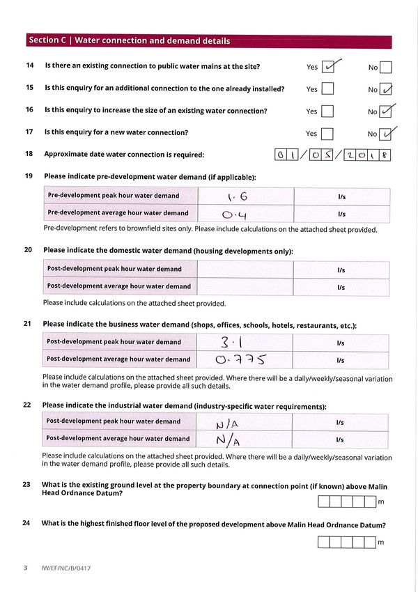
Engineering Services Report For
Proposed Student Housing Development
Westwood Hotel Site, Dangan, Upper Newcastle, Galway City
CONTENTS:
1.0 INTRODUCTION 1
2.0 SCOPE OF WORKS 3
3.0 SITE CONTEXT 3
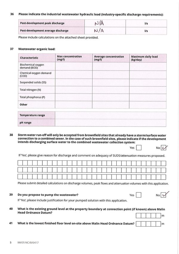
4.0 FOUL DRAINAGE 4
5.0 STORM DRAINAGE 6
6.0 FLOOD RISK ASSESSMENT 8
7.0 POTABLE WATER SUPPLY 13
Appendix A Existing Drainage Records from Galway City Council
Appendix B Pre-Development Enquiry to Irish Water
Appendix C Irish Water Response to Pre-Development Enquiry
Appendix D Attenuation Calculation
Appendix E OPW Floodmaps Report
This Report was prepared by CS Consulting Engineers for the benefit of its Client only. The contents of this
Report are shared with interested parties for information only and without any warranty or guarantee,
express or implied, as to the accuracy, reliability or completeness of its content. This Report cannot be
relied on by any party other than the party who commissioned it.
File Location: J:\A_JOBS\Job-A079\B_Documents\Reports\ESR
Job Ref: Author Reviewed By Authorised Issue Date Rev No.
A079 GL NB OS 17.05.18 A
Student Housing, Westwood Hotel Site, Galway City - Engineering Services Report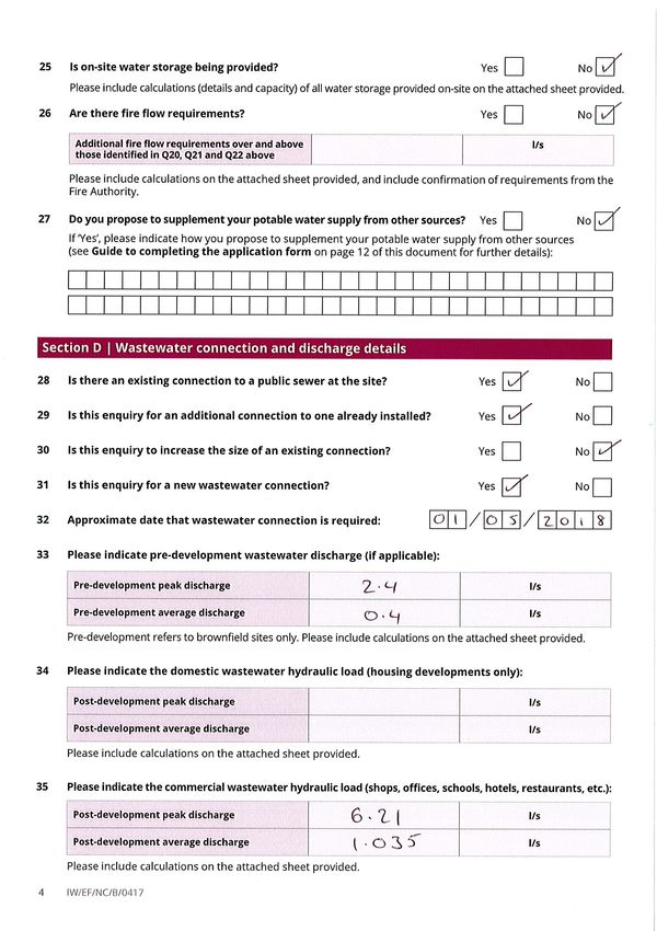
Engineering Services Report For
Proposed Student Housing Development
Westwood Hotel Site, Dangan, Upper Newcastle, Galway City
1.0 INTRODUCTION
Cronin & Sutton Consulting were commissioned by NTM ROI Seed Capital LP, in conjunction
with a multi-disciplinary design team, to develop an Engineering Services Report (ESR) to
accompany a planning application for the development will comprising of 63 apartments
with 394 number student bedrooms to be constructed on the site of the existing Westwood
House Hotel. It is proposed to demolish the existing hotel and construct the student
accommodation together with a reception area, social spaces, storage areas, all ancillary
facilities associated with student accommodation and a commercial retail/café space
with 24 number car spaces, (10 permanent and 14 temporary for summer use), an access
road, hard and soft landscaping areas etc. The purpose of this Engineering Services Report
is to review the potential services available to develop the proposed subject lands. This
report addresses drainage (both foul & storm), potable water and flood risk assessment
items for the site.
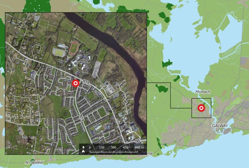
The development site is located within the curtilage of Galway City Council (GCC) and is
located to the west of the junction of the Upper Newcastle Road and the Thomas Hynes
Road (N59), see Figure 1 for site location map. The remainder of the site is bounded to the
Student Housing, Westwood Hotel Site, Galway City - Engineering Services Report 1
south and east by the Tudor Lawn and Dun Daingean residential estates respectively. The

total site area of the development is approximately 8,797 sqm (0.88 Ha) and is

predominately hardstanding in the form of the existing hotel structure and 97 car parking

spaces and access roads. Approximately 2,000m2 of a greenfield area exists on the site and

is predominately situated to the southern quarter of the site.

                      Figure 1 – Location of the Proposed Development Site
                                    (map data & imagery: Google)

A full description of the scheme is outlined in the Planning Report prepared by McCarthy

Keville O'Sullivan Ltd. and this report should be read in conjunction with all other documents

and drawings submitted with this planning application.

 Student Housing, Westwood Hotel Site, Galway City - Engineering Services Report            2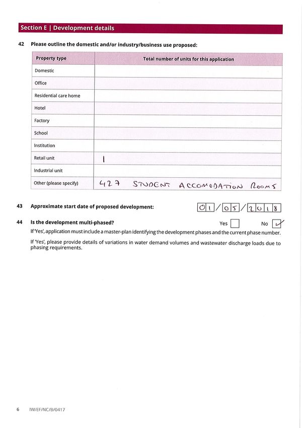
2.0   SCOPE OF WORKS

Cronin & Sutton Consulting were commissioned by NTM ROI Seed Capital LP to prepare the

following Engineering Services Report to accompany a planning application for the site at

the Westwood House Hotel, Galway City. In compiling this report CS Consulting liaised with

a number of third parties, namely:

       ●       Galway City Council,

       ●       Irish Water,

       ●       Clients representatives & Design Team.

In preparing this report the site was visited and assessed. No intrusive on site testing was

carried out and all conclusions indicated in this report were based solely on desk top

information.

 3.0   SITE CONTEXT

3.1 Site Description

The total site area of the development is approximately 8,797 sqm (0.88 Ha) The status of

the is existing site is predominately hardstanding in the form of the existing hotel structure

and car parking spaces and access roads, however approximately 2,000m2 is greenfield

situated to the southern quarter of the site. The topography of the existing site is relatively

flat with a small fall southward with ground levels along the northern boundary at 15.9m OD,

falling to 15.25m OD on the southern boundary (Note all levels to Malin Head Datum).

 Student Housing, Westwood Hotel Site, Galway City - Engineering Services Report             3
4.0   FOUL DRAINAGE

4.1 Existing Foul Drainage Infrastructure

Records obtained from Galway City Council (Appendix A) indicate an existing 225mm

public foul sewer running eastwards along the northern boundary of the development site,

on the Upper Newcastle Road. From a topographical survey taken of the site the existing

foul effluent of the hotel outfalls to this sewer.

4.2 Proposed Foul Drainage Infrastructure

The proposed development is to consist of 394 number student accommodation rooms, an

office, launderette (for the student use only) and a retail unit. Due to the proposed layout

of the new buildings, the existing foul outfall is deemed unfeasible to re-use and therefore

a new foul network and outfall will be constructed to cater for the foul effluent generated.

All foul effluent generated from the proposed development will be collected in pipes of

100mm, 150mm and 225mm in diameter and flow under gravity to the existing 225mm foul

sewers on the Upper Newcastle Road a new manhole. The drainage network for the

development will be in accordance with Part H of the Building Regulations and the

connection manhole to the requirements and specifications of Irish Water. The proposed

foul effluent generated by the subject lands will be completely separated from all surface

water flows, including post-attenuation storm flows so here will be a minimal impact on the

receiving drainage infrastructure.

 Student Housing, Westwood Hotel Site, Galway City - Engineering Services Report           4
A ‘pre-development enquiry’ was issued to Irish Water Ltd (Ref: 7204150673) in respect to

the proposed development and the response received from Irish Water confirmed that

there was adequate capacity in the public network to cater for the peak foul discharge of

6.21 l/s from proposed development.

A copy of the pre-development enquiry is included in Appendix B, with the respective

response letter in Appendix C and the proposed foul water drainage infrastructure and

routing plan is shown on drawings A079-001 included with this submission.

CS confirm, following the grant of permission, the development will be constructed in one

phase, with occupation of the development due in September 2020. Therefore, a

connection to the Irish Water sewer network on the Upper Newcastle will be required before

this date.

There are no existing Irish Water assets traversing the development site, so there is no

requirement for diversions or protection measures to be introduced. The existing 225mm foul

sewer on the Upper Newcastle Road is also deep enough to withstand construction traffic

loadings and we confirm no protection measures will be required.

 Student Housing, Westwood Hotel Site, Galway City - Engineering Services Report         5
5.0   STORMWATER DRAINAGE

5.1 Existing Stormwater Drainage Infrastructure

Records obtained from Galway City Council (Appendix A) indicate a 375mm diameter

public storm drain running eastwards along the northern boundary of the development site,

on the Upper Newcastle Road. From a topographical survey taken of the site the existing

surface water runoff of the hotel grounds outfall to this drain unattenuated.

5.2    Proposed Storm Water Infrastructure and SuDs

CS consulting had preliminary discussions with Mr. Joe McGuire of the drainage department

of Galway City Council and stated the existing development site discharged to the public

network unattenuated. Mr McGuire confirmed he would no objections to the development

if the existing discharge rate from the site could be reduced by 50%.

Analysis carried out based on the topographical survey of the site, indicates a flow of 30 l/s

currently discharging from the site for a 2-year return rainfall event. Based on the above, it

is proposed to limit the surface water flow from the proposed development to 15 l/s

(reducing the current flow by 50%). The total site area of the development site subject to

re-development is approximately 8,797 sqm (0.88 Ha) with an internal hardstanding area of

5,100 m2 for the external roads, footpaths and roof areas. Based on these parameters the

attenuation required for this development is 120 m3 of storage for the 1 in 100 year storm

event plus climate change (see Appendix D for calculations).

 Student Housing, Westwood Hotel Site, Galway City - Engineering Services Report            6
It is proposed to retain the storm water volumes in underground tanks (Aquacell Ltd or similar

approved), 14.0 x 6.0 x 1.45m deep (120m3) and to release the restricted storm water into

the public 375mm diameter surface water drainage system on the Upper Newcastle Road.

The last public manhole is to be constructed in accordance with Local Authority’s

requirements and the storm water flow will be restricted to 15.0 l/s by the use of a flow

control i.e. a hydrobrake or similar approved.

Additional SuDS features such as a swale to roadway, permeable paving to parking bays,

gravel drains to footpaths and waterbutts will be provided to reduce the volume of surface

water runoff entering the drainage network.

The drainage network for the development will be in accordance with Part H of the Building

Regulations and to best practices. The proposed surface water network will be completely

separated from all foul water flows, including post-attenuation so there will be a minimal

impact on the receiving drainage infrastructure.

The proposed surface water drainage infrastructure and routing plan is shown on drawing

A079-001 included with this submission.

 Student Housing, Westwood Hotel Site, Galway City - Engineering Services Report            7
6.0          FLOOD RISK ASSESSMENT

6.1    Level of Service

There is an existing inherent risk of any flood event occurring during any given year.

Typically, this likelihood of occurrence was traditionally expressed as a 1-in-100 chance of

a 100-year storm event happening in any given year. A less ambiguous expression of

probability is the Annual Exceedance Probability (AEP), which may be defined as the

probability of a flood event being exceeded in any given year. Therefore, a 1 in 100 year

storm event has a return period of 1% AEP flood event, similarly a 100% AEP can be

expressed as a 1-in-1-year event.

6.2    The Planning System and Flood Risk Management, Guidelines for Planning

Authorities set out the best practice standards for flood risk assessment in Ireland. These

standards are summarised in Table 1.0 (extract from Guidelines document). Under these

guidelines a proposed development site has first to be assessed to determine the flood zone

category it falls under.

             Flooding Source        Drainage          River         Tidal/Coastal

             Residential             1% AEP         0.1% AEP          0.1% AEP

             Commercial              1% AEP          1% AEP           0.5% AEP

             Water-compatible           -           >1% AEP          >0.5% AEP

             (docks, marinas)

                  Table 1.0 Summary of Level of Service – Flooding Source.

 Student Housing, Westwood Hotel Site, Galway City - Engineering Services Report              8
6.3 Climate Change
It is a requirement of Galway City Council and the Department of the Environment,
Community & Local Government (DoECLG) flooding guidelines (The Planning System and
Flood Risk Management, Guidelines for Planning Authorities) that the predicted effects of
climate change are incorporated into any proposed design, see Table 2.0.
Design Category Predicted Impact of Climate Change
Drainage 20% Increase in extreme rainfall depths
Fluvial (River flows) 20% Increase in flood flows
Mean Sea Level Rise +500mm
Table 2.0 The predicted climate change variations based on MRFS1 (OPW)
6.4 Flood Zones
The flooding guidelines categorise the risks associated with flooding into three areas, Zone
A, B & C. This categorisation is indicated as follows;
• Zone A – High Probability of Flooding. Where the average probability of flooding from
rivers and sea is highest (greater than 1% annually or 1 in 100 for river flooding or 0.5%
annually or 1 in 200 for coastal flooding).
• Zone B – Moderate Probability of Flooding. Where the average probability of flooding
from rivers and sea is moderate (risk between 0.1% annually or 1 in 1000 years and
1% annually or 1 in 100 years for river flooding, and between 0.1% or 1 in 1000 years
and 0.5% annually or 1 in 200 for coastal flooding).
1Mid-Range Future Scenario, OPW Assessment of Potential Future Scenarios, Flood Risk
Management Draft Guidance, 2009.
Student Housing, Westwood Hotel Site, Galway City - Engineering Services Report 9• Zone C – Low Probability of Flooding. Where the probability of flooding from rivers
and sea is moderate (risk is less than 0.1% annually or 1 in 1000 years for both rivers
and coastal flooding).
In accordance with DoECLG flooding guidelines (the Planning Systems and Flood Risk
Management Guidelines for Planning Authorities), residential dwellings are classified as
‘highly vulnerable developments’.
6.5 Flood Zone of Proposed Development
From a review of the OPW floodmaps website the proposed development is located within
the Zone C designation.
Figure.1.0 Source-pathway-receptor model from Flood Risk Management Guidelines.
6.6 Fluvial Flooding
The site is located approximately 550m from the Corrib River to the north east of the
development site and is deemed to be located in Zone C due to the local topography of
the development site to the river. A review of the Office of Public Works flood maps
database, www.floodmaps.ie, the area does not indicate any historical fluvial flooding
within close vicinity of the site. See Appendix E for the OPW Floodmaps Report.
Student Housing, Westwood Hotel Site, Galway City - Engineering Services Report 106.7 Tidal Flooding The sites location and elevation is such that it is not effected by tidal water bodies and as such tidal flooding is negligible. 6.8 Pluvial Flooding Pluvial flooding is flooding which has originated from overland flow resulting from high intensity rain fall. There are no records of flood events due to high rainfall events in the area but due the local topography we understand the risk of fluvial flooding to the site is negligible. See Appendix E for OPW Floodmaps Report, following a review of these maps the potential flooding the development site is deemed not to be at risk from pluvial flooding. The development itself will be designed to cater for a 100 year storm event in accordance with requirements of Galway City Council to minimise the risk of pluvial flooding. 6.9 Potential for Site to Contribute to Off-Site Flooding The existing site currently discharges surface water runoff to the public network unrestricted. The proposed development will reduce the runoff entering the public system by 50% provide attenuation sized for a 1 in 100 year storm event (120m3) including climate change By restricting the flow to a reduced rate, the likelihood of the proposed development adversely affecting the public drainage system or contributing to downstream flooding is mitigated. Student Housing, Westwood Hotel Site, Galway City - Engineering Services Report 11
6.10   Existing Off-Site Drainage

There is no evidence of hydraulic issues with the local drainage infrastructure.

Notwithstanding, the proposed entrances to the development will be slightly raised above

the adjoining highway to ensure the egress of flood water from the Upper Newcastle Road,

Thomas Hynes Road and Tudor Lawn does not occur.

6.11   Groundwater Flooding

No records of groundwater flooding have been found in proximity to the development site

and no basement construction is proposed, therefore groundwater flooding of the

development site is deemed negligible.

Student Housing, Westwood Hotel Site, Galway City - Engineering Services Report      12
7.0          POTABLE WATER SUPPLY

7.1    Existing Potable Water Supply

Records obtained from Galway City Council indicate a 100mm PVC public watermain

entering the development site from Tudor Lawn that currently supplies the existing hotel.

7.2    Proposed Potable Water Supply

It is proposed to re-use the existing water connection from the Tudor Lawn, to serve the new

development. The connection will be 110mm diameter PE pipework to Irish Water Ltd

standards and will be looped around the proposed development to supply each block as

well as for firefighting purposes.

24-hour water storage will be provided at roof level to each block via a pump system which

will in turn feed the student units below under gravity. Dual flush toilets and aeration taps to

sinks will also be provided to each unit to help reduce the demand of potable water.

A ‘pre-development enquiry’ was issued to Irish Water Ltd (Ref: 7204150673) in respect to

the proposed development and the response received from Irish Water confirmed that

there was adequate capacity in the public network to cater for the peak water demand

of 3.1 l/s from proposed development.

Student Housing, Westwood Hotel Site, Galway City - Engineering Services Report              13
However, it was confirmed in the ‘pre-development enquiry’ response that there is

insufficient pressure to serve the higher floors of the development with potable water for

fire-fighting purposes. To cater for fire-fighting it is proposed to provide additional breaker

tanks and booster pump sets adjacent to each hydrant to ensure sufficient flow to the

higher floors.

A copy of the pre-development enquiry is included in Appendix B, with the respective

response letter in Appendix C and the proposed watermain infrastructure and routing plan

is shown on drawing A079-002 included with this submission.

CS confirm, following the grant of permission, the development will be constructed in one

phase, with occupation of the development due in September 2020. Therefore, a

connection to the Irish Water sewer network on the Upper Newcastle will be required before

this date. There are no existing Irish Water assets traversing the development site, so there is

no requirement for diversions or protection measures to be introduced.

On behalf of Cronin & Sutton Consulting:

Gary Lindsay
Associate
BE, CEng, MIEI

Student Housing, Westwood Hotel Site, Galway City - Engineering Services Report              14
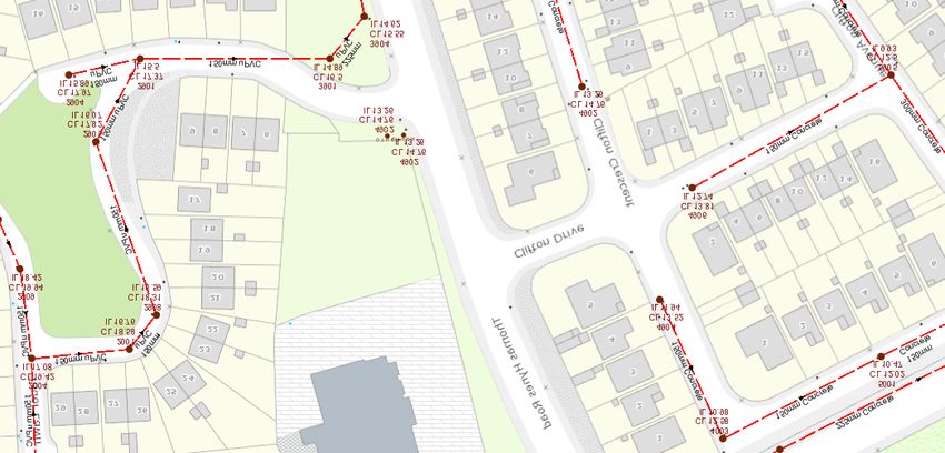
Appendix A

                Existing Drainage Records from Galway City Council

Student Accommodation, Westwood, Galway City - Engineering Services Report   15
Galway City Council Water Department
Septem ber 5, 2017 1:1,000
Flow Control Valves Part Closed Reservoir Potable Water 0 0.01 0.02 0.04 mi
Non-return Air Control Valves Potable Water Mains(Non Irish Water Own ed)
0 0.0175 0.035 0.07 km
Hydro Water Stop Valves Raw Water Untreated
Orifice Plate Non Bound ary Meter Pump Stations Potable Water
PRV Meter Water Network Structures Water Lateral Lines
PSV Group Scheme Abstraction Point Irish Water
Other Source Kisok Non IW
Boundary Valves Boundary Meter Water Fittings Water Abandoned Lines
Open District (Boundary Meter) Cap Water Casings
Closed Water Hydrants Other F itting
Part Closed Fire Hydrant Water Distribution Chambers
Non Bound ary Valves Fire Hydrant/Washout Pressure Monitoring Point
osi
Open Washout Water Mains(Irish Water Owned)
Closed Treatment Plant Untreated
For Non-SLA Local Authority staff use only.
"Copyright Ordnance Survey Ireland. All rights reserved.2017/14/CCMA/GalwayCityCouncil."Galway City Council Water Department
Septem ber 5, 2017 1:1,000
Gravity Main (Irish Water Owned) Other; Unknown 0 0.01 0.02 0.04 mi
Surface Storm Fittings 0 0.0175 0.035 0.07 km
Gravity Main (Non-Irish Water Owned) Vent/Col
Surface Other; Unknown
Storm Manholes Storm Discharge Points
Cascade Outfall
Catchpit Overflow
Hatchbox Soakaway
Lamphole Other; Unknown
Standard Storm Culverts
Other; Unknown Storm Clean Outs
osi
Storm Inlets Stormwater Pressure Mains
Gully Surface
Standard For Non-SLA Local Authority staff use only.
"Copyright Ordnance Survey Ireland. All rights reserved.2017/14/CCMA/GalwayCityCouncil."Galway City Council Water Department
Septem ber 5, 2017 1:1,000
Sewer Discharge Points Gully Foul 0 0.01 0.02 0.04 mi
Outfall Standard Overflow 0 0.0175 0.035 0.07 km
Overflow Other; Unknown Unknown
Soakaway Sewer Manholes Sewer Gravity Mains (Non-Irish Water owned)
Standard Outlet Cascade Combined
Other; Unknown Catchpit Foul
Sewer Clean Outs Hatchbox Overflow
Rodding Eye Lamphole Unknown
Flushing Structure Standard Sewer Pressurized Mains
Other; Unknown Other; Unknown Combined
Sewer Flow Control Valves Sewer Fittings Foul
osi
Treatment plant Vent/Col Overflow
Pump station Other; Unknown Unknown
Sewer Inlets Sewer Gravity Mains (Irish Water owned)
Catchpit Combined For Non-SLA Local Authority staff use only.
"Copyright Ordnance Survey Ireland. All rights reserved.2017/14/CCMA/GalwayCityCouncil."Appendix B
Pre-Development Enquiry to Irish Water
Student Accommodation, Westwood, Galway City - Engineering Services Report 16Appendix C
Irish Water Response to Pre-Development Enquiry
Student Accommodation, Westwood, Galway City - Engineering Services Report 17Letter Ref: CDSCOF1
Biggurat Westwood Ireland Lt
c/o Gary Lindsay
CS Group,
19-22 Dame Street
Dublin 2
3rd November 2017
Dear Sir/Madam,
Re: 7204150673 pre-connection enquiry - Subject to contract | Contract denied
Connections for 427 Room Student Accomodation Development at Westwood House Hotel, Dangan,
Upper Newcastle Road, Galway
Irish Water has reviewed your pre-connection enquiry in relation to
water and wastewater connections at Dangan, Upper Newcastle Road, Galway
Based upon the details you have provided with your pre-connection enquiry and on the capacity currently
available as assessed by Irish Water, we wish to advise you that, subject to a valid connection agreement being
put in place, your proposed connection to the Irish Water network can be facilitated.
The existing Westwood House Hotel has an existing connection to the Irish Water network and it is proposed to
utilise the existing connection point for the proposed development. The existing Irish Water water supply
network can facilitate the proposed additional demand asscociated with the proposed student accomodation
development. The confirmation of feasibility to connect to the Irish Water infrastructure does not extend to your
fire flow requirements. To guarantee a flow to meet the Fire Authority requirements you should provide
adequate fire storage capacity within your development.
The existing Westwood House Hotel has an existing connection to the Irish Water 225mm diameter wastewater
network which runs along the N59 Moycullen Road . The existing Irish Water wastewater network can facilitate
the proposed additional loading asscociated with the proposed student accomodation development. It is noted
that should a trade type effluent be proposed as part of the proposed development then a Trade Effluent to
Sewer Discharge Licence may require to be in place prior to a connection being made. The applicant is advised to
visit https://www.water.ie/for-business/trade-effluent/ in this regard.
The water and wastewater infrastructure should be designed and constructed in accordance with the IW Codes
of Practice and Standard Details.
You are advised that this correspondence does not constitute an offer in whole or in part to provide a connection
to any Irish Water infrastructure and is provided subject to a connection agreement being signed at a later date.A connection agreement can be applied for by completing the connection application form available at www.water.ie/connections. Irish Water’s current charges for water and wastewater connections are set out in the Water Charges Plan as approved by the Commission for Energy Regulation. If you have any further questions, please contact James O Malley from the design team at jomalley@water.ie. For further information, visit www.water.ie/connections Yours sincerely, Maria O’Dwyer Connections and Developer Services
Appendix D

                                Attenuation Calculation

Student Accommodation, Westwood, Galway City - Engineering Services Report   18
JOB NAME:Westwood Galway JOB NO: A079 Oct-17
TITLE: Preliminary Attenuation Calculations CALCS BY: CHECK'D:
GL RFM
RCD. 48 ISSUE. 1 REV. 1
Design Storm Return Period: 100 years
Nearest Rainfall Gauge: Sligo
Total Site Area: 0.80 ha
Roof Area: 0.00 ha ………….@ 100% Impervious
Hard Surface: 0.51 ha ………….@ 95% Impervious
Open Area: 0.29 ha ………….@ 5% Impervious
Effective Impermeable Area: 0.50 ha
Allowable Outflow Calculate
0.89
IH124: QBAR = 0.00108 x AREA x SAAR1.17 x SOIL2.17
SAAR: 919 mm
Soil Type: 3
SOIL: 0.37
QBAR/ha 3.95 l/s/ha
Specified Allowable Outflow 18.75 l/s/ha
Allowable Outflow 15.00 l/s
Duration Rainfall Intensity Discharge Proposed Contiguous Total Allowable Storage
100 Q Runoff Land Runoff Outflow Req'd
Year (= 2.71Ai) Runoff
(min) (mm) (mm/hr) (l/s) (m3) (m3) (m3) (m3) (m3)
2 5.8 174.9 237 28 0 28 2 27
5 11.6 138.6 187 56 0 56 5 52
10 17.1 102.3 138 83 0 83 9 74
15 22.0 88.0 119 107 0 107 14 94
30 29.2 58.3 79 142 0 142 27 115
60 35.8 35.8 48 174 0 174 54 120
120 44.0 22.0 30 214 0 214 108 106
240 55.0 13.8 19 268 0 268 216 52
360 62.7 10.5 14 305 0 305 324 -19
720 78.7 6.6 9 383 0 383 648 -265
1440 92.4 3.9 5 450 0 450 1296 -846
2880 112.2 2.3 3 546 0 546 2592 -2046
4320 123.2 1.7 2 600 0 600 3888 -3288
Storage required = 120 m3Appendix E
OPW Floodmaps Report
Student Accommodation, Westwood, Galway City - Engineering Services Report 19Summary Local Area Report
This Flood Report summarises all flood events within 2.5 kilometres of the map centre.
The map centre is in:
County: Galway
NGR: M 283 270
This Flood Report has been downloaded from the Web site www.floodmaps.ie. The users should take account of the
restrictions and limitations relating to the content and use of this Web site that are explained in the Disclaimer box when
entering the site. It is a condition of use of the Web site that you accept the User Declaration and the Disclaimer.
Map Legend
Flood Points
Multiple / Recurring
Flood Points
Areas Flooded
Hydrometric Stations
Rivers
Lakes
River Catchment Areas
Land Commission *
Drainage Districts *
Benefiting Lands *
* Important: These maps do
not indicate flood hazard or
Map Scale 1:5,229 flood extent. Thier purpose
and scope is explained in the
1 Result Glossary.
1. Quay Street Galway Jan 1995 Start Date: 17/Jan/1995
County: Galway Flood Quality Code: 3
Additional Information: Reports (1) More Mapped Information
Report Produced: 12-Jan-2018 17:29You can also read


