Carlisle Cycling and Walking Have your say - Cumbria County Council
←
→
Page content transcription
If your browser does not render page correctly, please read the page content below
Carlisle
                                    Cycling and
                                      Walking
 Have your say                      Consultation
   Public Consultation from:
    7 May to 28 May 2021
For more details and links to the
   questionnaire please visit:
      cumbria.gov.uk/
     cyclingandwalking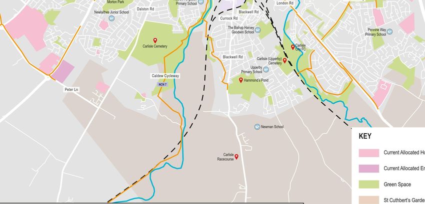
3% of people in the
 Carlisle area cycle to
  work, compared to
 the national average
         of 3%

    52% of people
 in the Carlisle area
  travel less than 5k
to work, compared to
the national average
       of 35%.

 25% of people in the
Carlisle area travel less
  than 2km to work,
   compared to the
   national average
        of 17%.

 20% of people in the
 Carlisle area walk to
work, compared to the
   national average
        of 11%.

  21% of children in
the Carlisle area walk
 to school compared
     to the County
   average of 27%.

2% of children in the
Carlisle area cycle to
school compared to
the County average
        of 3%.
Carlisle Cycling and Walking Consultation

  Summary
  We are holding a consultation on proposals to improve the cycling and walking
  network in Carlisle, in order to promote more active travel and to make everyone
  feel confident they can walk or cycle.
  Details of the proposed routes are included in this consultation document.
  We want you to provide feedback on these proposals so we can develop the best
  possible Local Cycling and Walking Infrastructure Plan for Carlisle. Please take the
  time to get involved, read this consultation document and provide your feedback.

Background
Cumbria County Council and Carlisle City Council are working together to deliver the
shared ambition to increase cycling and walking in the Carlisle area in line with the
Government's 'Gear Change: A Bold Vision for Cycling and Walking' (July 2020)
document. The Gear Change sets out a vision for travel revolution in England’s streets,
towns and communities:
  “Because the potential benefits are huge: Increasing cycling and walking can help
  tackle some of the most challenging issues we face as a society - improving air
  quality, combatting climate change, improving health and wellbeing, addressing
  inequalities and tackling congestion on our roads. Bold action will help to create
  places we want to live and work - with better connected, healthier and more
  sustainable communities. It will help deliver clean growth, by supporting local
  businesses, as well as helping ensure prosperity can spread across the country and
  level up our nation”.
A large proportion of residents within Carlisle live and work within the city. The compact
nature of the city and small travel to work area creates ideal conditions for cycling and
walking, with many trips to work occurring within the urban area to a small number of
major employers.
This shows there is significant potential in Carlisle for more journeys to be made by
walking and cycling if the right conditions are put in place. The implementation
of good quality cycling and walking infrastructure is key to getting more people to walk
and cycle.
Many of us recognise the challenges of climate change and the urgent need to act. We
know that being active is good for us and more of us have been walking and cycling
throughout the Covid-19 pandemic and we would like to encourage this to continue.
When asked what would make people maintain this, safe walking and cycling routes
were the number one priority.
As part of this partnership working we are developing a Local Cycling and Walking
Infrastructure Plan (LCWIP) for Carlisle. This will identify a cycling and walking network
and the improvements identified will make it easier for everyone, regardless of age or
ability to feel confident that they can walk or cycle.
The improvements identified in the LCWIP will be used to help to secure funding.
Delivery of the improvements is subject to funding being secured.

                                             3
Development and delivery of the Plan
The Carlisle LCWIP aims to support green growth through improving connectivity, both
within Carlisle City and to Longtown and Brampton. Suggested cycling and walking
routes have been identified and a draft priority network is presented as part of this
consultation. Some initial routes have been identified for phased delivery where
funding is available.
Delivery of the Carlisle LCWIP is planned in the following phases:
• Phase 1: Delivery of improvements identified as part of the Carlisle Southern Link
  Road will begin in the Spring of 2022. The project includes a segregated cycling and
  walking track on the northern side of the new road. It will include cycling and walking
  bridges at two of the major road crossings and a connection with the Caldew
  Cycleway which is part of National Cycle Network Route 7. The funding has been
  secured from the Housing Infrastructure Fund.
• Phase 2: Delivery of improvements to be identified as part of the development of
  St Cuthbert’s Garden Village. These will be delivered as the Garden Village is
  developed, and will include an east to west greenway across the site, connections to
  the Caldew Cycleway and routes into Carlisle City Centre.
• Phase 3: Delivery of improvements identified as part of the Carlisle Cycling and
  Walking Plan (Subject to securing funding).
Having a clear plan for cycling and walking in Carlisle will provide the best chance of
securing funding for future phases.

                                            4
Carlisle Cycling and Walking Consultation
Cycling
Existing Cycle Network Existing Cycling Network
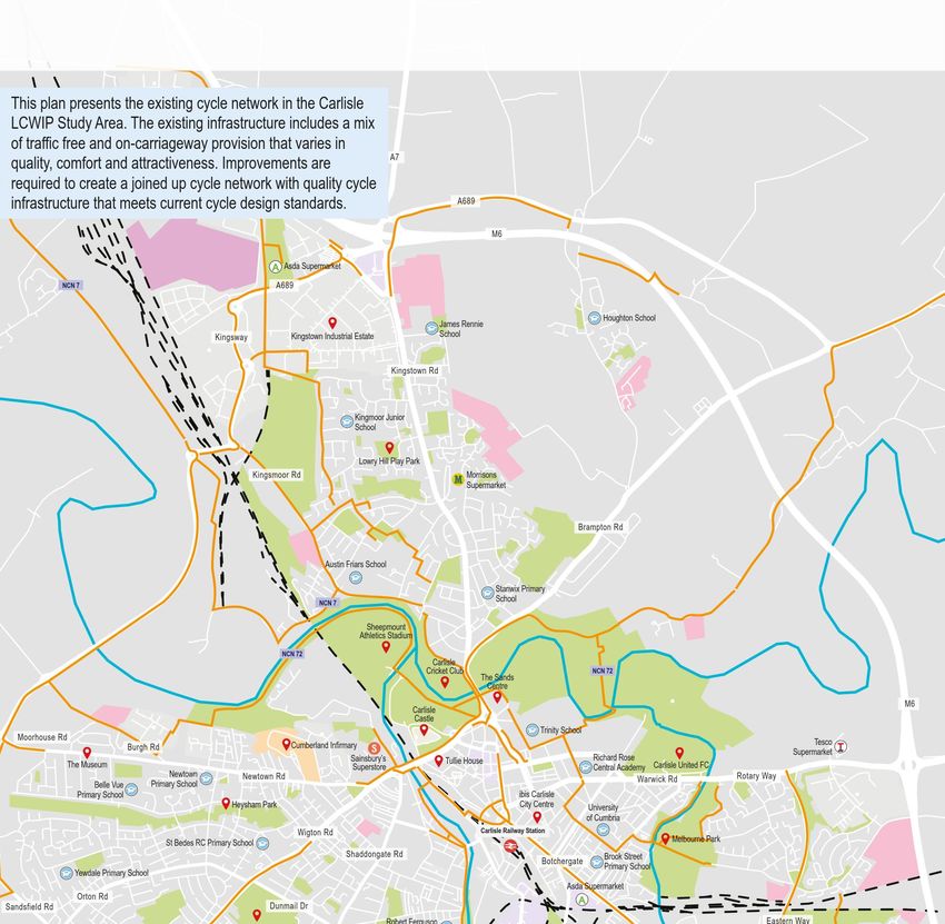
This plan presents the existing cycle network in the Carlisle
LCWIP Study Area. The existing infrastructure includes a mix
As part of developing the Plan for
of traffic free and on-carriageway provision that varies in
quality, comfort and attractiveness. Improvements are Please refer to A7
required to create a joined up cycle network with
M6
quality cycle
infrastructure that meets current cycle design standards. A689
M6
cycling in Carlisle the existing
NCN 7
‘Existing Cycling Network’ A Asda Supermarket
A689
network has been considered.
LOW CROSBY
CARGO Houghton School
James Rennie
full scale map at Although there is already some
Kingsway Kingstown Industrial Estate School
Kingstown Rd
back of document Kingmoor Junior
School
Lowry Hill Play Park
existing cycling network, this may
GRINSDALE
Kingsmoor Rd
BELAH
Morrisons
Supermarket
Brampton Rd
not meet the standards set out in
Austin Friars School
Stanwix Primary
the new government guidance.
NCN 7
School
Sheepmount
We have also looked at where
Athletics Stadium
NCN 72
Carlisle
Cricket Club NCN 72
The Sands
Centre
Moorhouse Rd
Burgh Rd Cumberland Infirmary
Sainsbury’s
Carlisle
Castle
Tullie House
Trinity School
Richard Rose
Tesco
Supermarket
T
M6
A69
people want to travel from and to.
This includes travel from residential
The Museum Superstore Central Academy Carlisle United FC
BELLE VUE Newtown Newtown Rd Rotary Way
Warwick Rd
Belle Vue Primary School
Primary School ibis Carlisle
Heysham Park City Centre University
of Cumbria DURRANHILL
areas to key destinations such as
Wigton Rd Carlisle Railway Station
St Bedes RC Primary School Melbourne Park
Shaddongate Rd Brook Street
Botchergate
Primary School
Yewdale Primary School
Asda Supermarket
employment centres, rail and bus
Orton Rd A
Sandsfield Rd Dunmail Dr
Robert Ferguson Eastern Way
Morton Park Primary School London Rd
MORTON
Dalston Rd
Newlaithes Junior School Blackwell Rd
stations, schools, key services,
Currock Rd
The Bishop Harvey
Pennine Way
Goodwin School
Primary School
CURROCK Carlisle GARLANDS
Carlisle Cemetery
supermarkets, green spaces and
City FC
Blackwell Rd Carlisle (Upperby)
Cemetery
Upperby
BLACKWELL Primary School
Caldew Cycleway
Peter Ln
NCN 7
Hammond’s Pond
M6
employment sites.
CARLETON
Newman School
KEY This plan shows key destinations
and the existing cycle network.
Carlisle Current Allocated Housing Site
Racecourse
Current Allocated Employment Site
Green Space
St Cuthbert’s Garden Village
From this we can see gaps and where
Examples of varying standards of existing provision in Carlisle
NCN
Schools / Colleges
National Cycle Network
improvements could be made.
Railway Station
Railway Line
River
Eden Bridge – cycle
NCN 7 lane London Road – poorly maintained Michaelson Road - no existing
with obstructions Infrastructure on signed route Existing Cycle Network
cycle infrastructure
Suggested Cycle Network Suggested Cycling Network
This plan shows the suggested cycle network Main Link
for the Carlisle Study Area. The network has Typical traffic volume: More than 5000
We have looked at where people
been developed following a data analysis
exercise to understand where people travel Please refer to A7
Typical speed: 40mph
Example infrastructure: Fully
segregated cycle infrastructure e.g.
now and where they will travel in the future. M6
A689
M6
fully kerbed cycle track.
in the city are currently traveling to
NCN 7
‘Suggested Cycling Network’ A Asda Supermarket
A689
Local Link
Typical traffic volume: 3000-5000
Typical speed: 30mph
Example infrastructure: Light
and from and have considered
future changes to the town,
LOW CROSBY
CARGO Houghton School
segregation e.g. planters.
James Rennie
full scale map at
Kingsway Kingstown Industrial Estate School
Leisure Link
including new housing sites.
Kingstown Rd
Typical traffic volume: 0 (off-carriageway)
back of document Kingmoor Junior
School
Typical speed: 0mph (off-carriageway)
Example infrastructure: Attractive
GRINSDALE
Kingsmoor Rd
Lowry Hill Play Park
BELAH
Morrisons
Supermarket
and traffic free links.
Information has come from National
Austin Friars School
Brampton Rd
Census data, school and workplace
NCN 7
Sheepmount
Stanwix Primary
School travel surveys and traffic counters.
Athletics Stadium
NCN 72
Carlisle
Cricket Club
Carlisle
Castle
The Sands
Centre
NCN 72
M6 This information was then used to
identify where most people want
Trinity School
Moorhouse Rd
Cumberland Infirmary Tesco A69
Burgh Rd T
Supermarket
Sainsbury’s Tullie House Richard Rose
The Museum Superstore Central Academy Carlisle United FC
BELLE VUE Newtown Newtown Rd Rotary Way
Warwick Rd
Belle Vue Primary School
Primary School ibis Carlisle
Heysham Park
St Bedes RC Primary School
Wigton Rd
Shaddongate Rd
City Centre
Carlisle Railway Station
Botchergate
University
of Cumbria
Brook Street
Melbourne Park
DURRANHILL
to travel to and where they are
coming from.
Primary School
Yewdale Primary School
Asda Supermarket
Orton Rd A
Sandsfield Rd Dunmail Dr
Robert Ferguson Eastern Way
Morton Park Primary School London Rd
MORTON
Dalston Rd
Newlaithes Junior School Blackwell Rd
By applying these journeys to the
Currock Rd
The Bishop Harvey
Pennine Way
Goodwin School
Primary School
CURROCK Carlisle GARLANDS
Carlisle Cemetery
Caldew Cycleway
NCN 7
BLACKWELL
Blackwell Rd Carlisle (Upperby)
Upperby
Primary School
Cemetery
City FC
existing network, a suggested
Peter Ln
Hammond’s Pond
M6
network has been mapped. This is
Newman School
CARLETON
shown on the plan.
Carlisle
Racecourse
St Cuthbert's Garden
Village Greenway
Newbiggin Road
NCN 7 extends
south of Dalston
KEY
DALSTON
Current Allocated Housing Site Green Space Schools / Colleges NCN National Cycle Network River Local Link
NCN 7
Current Allocated Employment Site Railway Station Railway Line St Cuthbert’s Garden Village Main Link Leisure Link
5
Albert
Row
e
Gat
er
Street
Ca
ost
rlyl
ys
Byron
ern Cast
th Square
Mar
es
Draft Priority Cycle Network
Pat le
Stre Chatswor
Co
Abb
St
et
urt
N
Stree
ewLane
ey
Hartin
Stre
et Lane
Draft Priority Cycle Network
t
Grapes
gton
Greenmarket
Lismo
St Albans
Walk
Place
re Place
Engl
ish
Currie
Stree Street
Cast Chiswick
How
t le Earls Lane
Stree
The Abbey
ard
t
Street
e
Plac
Street
Qu
The Maltings s Lan Lonsdale
een
e
bert
eet
Str
Warwick Rd
Cuth
Milbo
St
Str
eet Square
St Pauls
by
Street
urne
ion
Bru
Wa
Bank
Agl
nto
rwi
Stree
n
ck
We
Ave
Sq
st
nue
uar
t
Wa
e
et
lls
Wa
Stre
Lismo
rwi
Haw
Crosby Street
Rigg t
ck
rt
et
Street Riv
Sho
Stre
Cour
ick
er
Sq
eet
Earl
re Stree
This plan shows the draft priority network.
et
Stre
uar
Str Broad Friars
Stre
Bla
Stre
ing
guard et Tul
e
ral
We have held workshops with partners and
Street
ckf Har
Engl
lie
Irth
et
the s riar
red
Morto t Stre Stre
t
We n Stree
ish
Eld
Str et et
et
Street
t eet
Stree
Stre
de
This includes the Carlisle Southern Link
Arca
Viaduct Estate Road
ce
t
York
Milb
Duke t
Gra
ther
Street Low ril Stree
Sill
ourn
Bac Pette
oth
khou Bar
e
Street
w ton
Str
ses
Please refer to
Roa
Dixons
et
Road Scheme and the emerging cycle
Potter l Ro s
eet
Wal
Stre
Court Pla
d
s Place k Bus ade ce s Lane
Myd
York
fred
Eng h Cit Halfey
nt
Kenda Bro Jac
dlet
lish
sce
Wil
eet
l Stree w kso
Dam
Str
Cre
on
t n
side
eur
Stre
network proposed as part of St Cuthbert’s
nue Str
ey
A7
Milb
eet
eet
Vas
Orf
Ave
et
Bruns
Str
n Ce
ourn
ce
Fin Newc cil
ry
Pla
astle
stakeholders to help identify a draft priority
rge
e
Str
wick
Stree Boro
Cre
d
eet
et
Ma
tlan
t ugh
Stre
sce
Garden Village development.
Stree
Por
Stre Jes
John
ry
nt
et mo
Ma
Rob Court Square
t
nd
ert
Gard Str
eet
M6
et
ens No
Stre
rma
n
th
A689
Str
Sou
eet
et
Botchergate
Stre
Noo
ad
Charlotte Street
Hill k Stre
Ro
eet
rles
ton et
Rydal Street
Str
pe
eet
n Nook
Den
Cha
Rav
nho
ool
t Str
en
Sta
Sch
Tai
Bar Bow Stre
Rave
Milbou
rock man et
M6
network based on the suggested network ‘Carlisle Draft Priority Cycle Network’
et
Stre Stre
t
e
Stre
Stree
Fur
rac
et et
rne
ze
Ter
Shef
liam
Carlisle Railway Station
et
field Wate
Str
Stre
e
Street
all
r Stree
lros
Wil
Stree
eet
Fus
Rand
t
ry
t
Me
ehi
Hen
ll
Str
th
t eet Melb
Sou
duc ourn
Via e Road
A Asda Supermarket
a
tori Bow
Elm
James Street
Vic ma
Str n
nt
eet Edw Stre Marg
sce
Ros et aret
et
ard
t
ad
Cre
Stree
y Stre
Pugin Lorn e Creig
A689
Str
Ro
e Stree Cou
Stree hton
ne
eet
et
ale
t rt
Lor
How Gard
Stre
Gre
Place
t Sybi
aide
ard
e l Stree ens
We
se
Str
Adel
t
identified from the data.
et
Clo
ount
eet
Stre
Lancaster Street LOW CROSBY
Linto
eet
Kenm
Walk
Rob n Stree
e
Lim
Str
ert
Stre t
on
Lime
ws
et Wats
CARGO Houghton School
et
He
eet on
et
Stree
s Stre
Stre
Thoma Lam Str
James Rennie Flo t
s Street plug n's ces
London Road
d
wer
et
har
Bed h phe Prin
Stre
Collin Stre Str
full scale map at
Orc
School
ford gwood et Ste eet Dela
Kingsway Kingstown Industrial Estate
et
Roa St
h John
Stree Ga goa
River Caldew
Stre
et
d t rde
Stre
et Stre
n et
cowe
Stre Stre
Nelson Street
Sout
wn
Lindi
Empi Nelson Lord t et
Cro
sfarn
Blen
et
re Street n Stree e Cour
Road
Stre
Trafal Albio
gar t
der
Street
race
xan
Far
et
ce
Ter
nes
Stre
Ale
Kingstown Rd
Lang Terra ide
Street
e
North
view
n
ouff
Clo
mso
dale
eet
Metca South se
odr
Roa
eet
lfe
Tho
Str
d Street
Street
Clifton
Wo
Str
ald
se
Talbo
Yew Tree Court
Clo
e
Osw
farn
t Road
Court
Colville
ide
dis
Colvill
East Dav
Linton
Tra
nes
e Terrac
Lin
Nelso msi
This has enabled us to identify a draft priority back of document
id
orland
e
Far
n Street Stre de
et Wa
Close
y
y Street
eet
Westm
Str
St
rt's
Road
Nic
Kingmoor Junior
Morle
hbe
hol
Holstead
Teasdal
as
Cut
St Jame's
St Jame's Lewi Gat
Currock Rd
Close
School
Northu s Cour Jack Watt
St
Cumbe e
Avenu mberla t
e Place
rland
Street
e
Close
Court nd Street
Graha
m Stree
Rome
t
Westmorla
Norfolk
East Norfolk Street
nd Street
Lowry Hill Play Park
Goschen
Road
cycle network that either has funding secured or
Court
Colville
Kingsmoor Rd Morrisons
BELAH
Street
GRINSDALE Supermarket
Brampton Rd
is likely to secure funding in the future. Austin Friars School
Stanwix Primary
School
Sheepmount
The first phase will be the cycle and walking
Athletics Stadium
Carlisle
Cricket Club
The Sands
Centre
infrastructure that will accompany the Carlisle Moorhouse Rd
Burgh Rd Cumberland Infirmary
Sainsbury’s
Carlisle
Castle
Tullie House
Trinity School
Tesco
Supermarket
T
M6
A69
Southern Link Road and will provide connectivity
The Museum Superstore Carlisle United FC
BELLE VUE Newtown Newtown Rd Rotary Way
Warwick Rd
Belle Vue Primary School
Primary School ibis Carlisle
Heysham Park City Centre University
of Cumbria DURRANHILL
for cyclists along the length of the new classified
Wigton Rd Carlisle Railway Station
St Bedes RC Primary School Melbourne Park
Shaddongate Rd Brook Street
Botchergate
Primary School
Yewdale Primary School
Asda Supermarket
road. The scheme has also been designed to
Orton Rd A
Sandsfield Rd Dunmail Dr
Robert Ferguson Eastern Way
Morton Park Primary School London Rd
MORTON
Dalston Rd
Newlaithes Junior School Blackwell Rd
ensure connectivity to existing walking and
Currock Rd
The Bishop Harvey
Pennine Way
Goodwin School
Primary School
CURROCK Carlisle GARLANDS
Carlisle Cemetery
cycling routes in the vicinity of the scheme. The
City FC
NCN 7 Blackwell Rd Carlisle (Upperby)
Cemetery
Upperby
BLACKWELL Primary School
Caldew Cycleway
route will facilitate a number of links to adjoining Peter Ln
Hammond’s Pond
M6
roads and will improve connectivity with the Newman School
CARLETON
Caldew valley. The route will also facilitate a new Carlisle
Racecourse
connection with the Cumbria Way/National Cycle St Cuthbert's Garden
Village Greenway
Network Route 7 at a point to the north of the
road, in the Caldew valley. At the western end of Newbiggin Road
the shared-use path, a link will be provided to the KEY
Current AllocatedDALSTON
Housing Site Green Space Schools / Colleges NCN National Cycle Network Phase 1: Carlisle Southern Link Road Phase 2: St Cuthbert’s Garden Village
existing CNDR shared-use path. Current Allocated Employment Site Railway Station Railway Line River St Cuthbert’s Garden Village Phase 2: Quieter Alternative Route Phase 3: Future developments
The second phase will be links within the
St Cuthbert’s Garden Village and links to the city
and key destinations. Sustainable travel within
and to and from the Garden Village is a key
principle and has a key role in defining the
identity of the Garden Village in relation to place
making and movement, where clear and
attractive routes need to be provided.
The draft priority network provides connectivity
from residential areas in Carlisle to key destinations
such as workplaces, schools, community hubs,
railway stations and greenspaces.
The improvements would include segregated
cycleways into the city centre and improved
access to green spaces.
6
Carlisle Cycling and Walking Consultation

Cycling Improvements
The new cycling improvements will be following the updated guidance from the
Department for Transport on Cycle Infrastructure Design. This guidance emphasises the
requirement of inclusive cycling so that people of all ages and abilities are considered.
The new standards of design for cycling will be much higher than in the past and look
to include cycle provision that is physically protected from traffic and separation of
pedestrians from cyclists on main routes.
There are five fundamental design principles for all cycle infrastructure that will ensure
it is accessible to all. When people are travelling by cycle, they need networks and
routes that are:
•   Coherent - part of a wider strategic network that provide access to key destinations;
•   Direct - reach their destination as directly as possible;
•   Safe - of a high quality and designed to standards that meet safety requirements;
•   Comfortable - accessible and attractive for all abilities;
•   Attractive - contribute to good urban design by integrating with and complementing
    their surroundings.
Designs following these guidelines should provide infrastructure that is accessible to all
and should help ensure that designs deliver a network that is safe and encourages more
people to cycle.
Funding could come from a range of sources including the Department for Transport
funding for local walking and cycle infrastructure plans. It is key that any funding bid to
Government demonstrates local support.

                                             7
Walking
Walking forms part of most daily journeys in Carlisle and in developing a Plan, local
walking routes and improvements to encourage walking have been considered.
How much people may enjoy walking can vary significantly based on their ability,
confidence and circumstances, for example a missing dropped kerb can become a
serious barrier for those with a pushchair or those with mobility difficulties; likewise
uncontrolled crossings or a lack of tactile paving can prove a major barrier for the
visually impaired.
A plan has been produced to help gauge opinion on the existing walking routes and
any required improvements that people think are needed.
The plan features residential areas, employment sites, rail stations, bus stops,
supermarkets, local community hubs, local parks and green spaces, access to the coast
as well as key features such as controlled and uncontrolled crossing points.
We would like to understand what improvements are needed to encourage more
walking; features such as bridges, road crossings, pavements, dropped kerbs and places
to rest, as well as improvements to the environment of the route.
The responses from the public will help us to understand the range of very localised
issues across the study area which can become major barriers for people to travel by
foot for their daily journeys.
We will use the consultation to identify the issues and opportunities to remove barriers
that currently stop more people walking in Carlisle.
Walking in Carlisle
We would like to understand where pedestrian
infrastructure improvements are needed to make
M6
Please refer to A7
A689
journeys on foot safer, comfortable and more attractive.
Walking Infrastructure Improvements could include:
• Improved Crossing Facilities;
M6 • Footway widening and resurfacing;
‘Walking in Carlisle’
A Asda Supermarket
A689
• Lighting to improve safety; and
• Wayfinding and signage.
LOW CROSBY
CARGO Houghton School
James Rennie
full scale map at
Kingsway Kingstown Industrial Estate School
Kingstown Rd
back of document Kingmoor Junior
School
Lowry Hill Play Park
Kingsmoor Rd Morrisons
GRINSDALE BELAH Supermarket
Brampton Rd
Austin Friars School
Stanwix Primary
School
Sheepmount
Athletics Stadium
Carlisle
Cricket Club
The Sands
Centre
M6
Carlisle
Castle
Trinity School
Moorhouse Rd
Cumberland Infirmary Guildhal Tesco A69
Burgh Rd T
Museum Supermarket
Sainsbury’s Richard Rose Carlisle United FC
The Museum Superstore Central Academy
BELLE VUE Newtown Newtown Rd Rotary Way
Warwick Rd
Belle Vue Primary School
Primary School ibis Carlisle
Heysham Park City Centre University
of Cumbria DURRANHILL
Wigton Rd Carlisle Railway Station
St Bedes RC Primary School Melbourne Park
Shaddongate Rd Brook Street
Botchergate
Primary School
Yewdale Primary School
Asda Supermarket
Orton Rd A
Sandsfield Rd Dunmail Dr
Robert Ferguson Eastern Way
Morton Park Primary School London Rd
MORTON
Dalston Rd
Newlaithes Junior School Blackwell Rd
Currock Rd
The Bishop Harvey
Pennine Way
Goodwin School
Primary School
CURROCK Carlisle GARLANDS
Carlisle Cemetery
City FC
Blackwell Rd Carlisle (Upperby)
Cemetery
Upperby
BLACKWELL Primary School
Hammond’s Pond
Peter Ln
M6
CARLETON
Newman School
Carlisle
Racecourse
KEY
DALSTON
Local Plan Sites - Housing Green Space Schools / Colleges River Footpath Bridleway
Local Plan Sites - Employment Railway Station Railway Line St Cuthbert’s Garden Village Byway open to all traffic
8
Carlisle Cycling and Walking Consultation

                   9
Have your Say
We want your feedback on the proposals for cycling and walking in Carlisle. Please let
us know:
• Does the cycling network connect the places you want to go to?
• Where would you like to see improvements to walking routes?
• What would encourage you to cycle and walk more?
If possible please respond at: cumbria.gov.uk/cyclingandwalking
If you do not have internet access, please complete the following questionnaire and
return FREEPOST CUMBRIA COUNTY COUNCIL by 28 May 2021.
Paper copies of this consultation document are available, please see our webpage for
further details.

Information provided in response to this consultation, including personal information,
may be subject to publication or disclosure in accordance with the access to information
regimes. These are primarily the Freedom of Information Act 2000 (FOI), the Data
Protection Act 1998 and the Environmental Information Regulations 2004. Under the
FOI, there is a statutory Code of Practice with which public authorities must comply and
which deals with our confidentiality obligations among other things.

  Next Steps
  Feedback from the consultation will be shared on Cumbria County Council's
  Cycling and Walking web pages and used to inform the networks we take forward
  as part of developing the Local Cycling and Walking Infrastructure Plan for Carlisle.

                                           10
Carlisle
Cycling and
Walking
Questionnaire ConsultationThe suggested and draft priority cycling and walking plans demonstrate how the
networks can connect people with the places they travel to on everyday journeys
including employment, schools or leisure.
We would like to know if our plans have connected the right places and, if they have
not, give you the opportunity to tell us and share your ideas with us. We would like to
hear about your own cycling and walking trips and tell us about the barriers that you
face that may prevent you from cycling or walking, and how you would change the
places you live to remove these barriers. Your responses will help us to identify and
develop the cycling and walking schemes that will be included in the LCWIP.
Before completing this questionnaire, please read the consultation document and
look at the cycling and walking network plans. This will provide you with information
to answer the questions.
About you
1 Which of the following best describes the reason for your interest in this
consultation? (please tick all boxes applicable)
I live here I work here I study here I live nearby
I own a business here I do the school run here I commute here
I do my shopping here I’m here for leisure My children go to school here
I am a visitor here I cycle in this area for commuting/leisure Other
2 What is Your Postcode?
3 a) Do you currently make journeys by cycling and if so how often?
Yes every day Yes every week Yes occasionally No
b) Do you currently make journeys by walking and if so how often?
Yes every day Yes every week Yes occasionally No
c) For what purpose are the journeys you make by cycling and walking?
(Please describe the purpose and tick the way you travel)
Purpose Cycling Walking
12Carlisle Cycling and Walking Consultation
Your local cycling and walking network
4 Do the existing cycling routes connect you with the places you wish to go?
Yes Partially No
5 a) Do the routes shown in the draft priority cycling network plan, connect you
with the places that you wish to cycle?
Yes Partially No
b) If you have answered‘Partially’ or‘No’ to the above question, please
provide further feedback.
Location Comment
6 a) Do the existing walking routes connect you with the places you wish to go?
Yes Partially No
b) If you answered 'Partially' or 'No', please provide further feedback on where
and what improvements would you like to see.
Location Improvement
7 Would you like to see more money spent on cycling and walking in Carlisle?
Yes No Don’t know
13Barriers to cycling and walking
8 Do any of the following make it difficult for you to cycle?
(Please select your top 3)
Quality of routes
Busy roads
Feeling unsafe
Difficult junctions to cross
Lack of cycle parking
Quality of street scape and public space
Poor air quality
Lack of street lighting
Not enough information on possible routes / lack of wayfinding
No access to a bike
Confidence
Indirect Routes
Unsuitable terrain / geography
Other, please state
9 Do any of the following make it difficult for you to walk?
(Please select your top 3)
Quality of route
Busy roads
Feeling unsafe
Difficult junctions to cross
Quality of street scape and public space
Poor air quality
Lack of street lighting
Confidence
Indirect Routes
Unsuitable terrain / geography
Other, please state
Changing to cycling or walking
10 a) Do you make any journeys by car to places that are within walking or cycling
distance?
Yes Partially No
b) If yes, for what purpose do you make journeys by car to places that are within
cycling or walking distance?
To or from work
To or from school, college or adult education
To or from the shops
To transport children or other people
To or from a leisure/sports activity
For leisure
Other - please specify
14Carlisle Cycling and Walking Consultation
11 What would encourage you to cycle more?
(Please select your top 3)
Cycle routes separated from other modes of travel
Traffic free neighbourhoods - including road closures
Greater priority for cyclists at junctions and crossings
Direct cycle routes
Better wayfinding / signage
Cycle training, information and initiatives
More secure and convenient cycle parking facilities
The cycling routes proposed in this consultation document
Lower speed limits
Less traffic on the roads
Higher costs of motoring
Higher public transport fares
Better driver attitudes towards cyclists
Nothing would encourage me to cycle more
Better air quality
Other, please state
12 What would encourage you to walk more?
(Please select your top 3)
Better maintained pavements / footways
More road crossings
More CCTV cameras
Less traffic on the roads
Lower speed limits
Having more time available
Higher costs of motoring
Higher public transport fares
Better air quality
More direct walking routes
Nothing would encourage me to walk more
Other - please specify
13 Would improvements to cycling and walking routes encourage you to
walk and/or cycle more often?
(Please select all that apply)
Yes, I think I would cycle more often
Yes, I think I would start cycling
Yes, I think I would walk more often
Yes, I think I would start walking
No
15Delivery in Carlisle
We are trying to connect the places where people wish to get to and sometimes there
are different ways of doing this. This could be via more direct routes provided on or by
the local road network or quieter routes away from the local highway network through
residential areas and parks past local amenities and education facilities but will likely
be less direct.
14 Which of the following would you be more likely to use?
A direct route from Junction 42 of the M6 and along the A6 London Road and
Botchergate into the town centre
A less direct route, a quieter alternative from Junction 42 of the M6 along the River
Petteril linking into the town centre (red dotted line on Draft Priority Cycling
Network Plan)
15 Are there any other routes that you would like to see developed as quieter
alternatives to the draft priority network?
(If so please tell us what areas)
16Carlisle Cycling and Walking Consultation
16 Phase 2 of the Draft Priority Network Plan identifies proposed St Cuthbert's
Garden Village (SCGV) cycling and walking routes.
a) Which of these routes would you like to see prioritised?
b) Are there any routes currently not included in this?
(If so, please tell us where you would like to see these provided)
1717 Are there any SCGV cycling and walking routes that are currently not included in
the proposed phase 2 draft priority network plan?
18Carlisle Cycling and Walking Consultation
Consultation feedback
Did we provide enough information for you to properly respond?
Yes Partially No
Did the questionnaire allow you to express your opinions fully?
Yes Partially No
Thank you for engaging in the consultation
190300 303 2992
0300 303 2992
0300 303 2992
0300 303 2992
0300 303 2992
0300 303 2992
20You can also read


